Showing 23783 items
matching main
-
 Eltham District Historical Society Inc
Photograph, Peter Pidgeon, North bound traffic routed up Main Road during Bolton Street upgrade, Eltham, 13 November, 2017, 13/11/2017
Born Digitalbolton street upgrade, eltham, streets, main road, traffic -
 Eltham District Historical Society Inc
Photograph, Peter Pidgeon, Local History Centre, Main Road during Bolton Street upgrade, Eltham, 13 November, 2017, 13/11/2017
Born Digitalbolton street upgrade, eltham, streets, main road, local history centre -
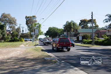
 Eltham District Historical Society Inc
Photograph, Peter Pidgeon, Main Road looking east towards Fitzsimons Lane roundabout during Bolton Street upograde, 13 November 2017, 13/11/2017
North bound lane closure. Born Digitalbolton street, bolton street upgrade, eltham, streets, main road, fitzsimons lane -
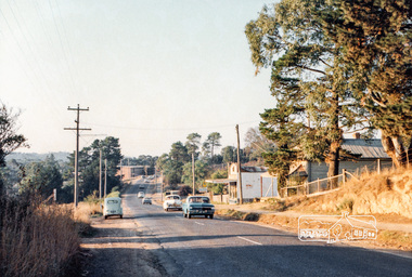
 Eltham District Historical Society Inc
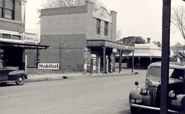
Photograph, Russell Yeoman, Intersection of Fitzsimons Lane with Main Road, Eltham, c.1969, 1969c
Digital file only; created from original colour positive slide transparencystreets, eltham, main road, fitzsimons lane, russell yeoman collection -
 Eltham District Historical Society Inc
Photograph, Michael Aitken, Main Road, Eltham, c.1967, 1967c
Looking north from near Bridge Street. York Street on right.Digital file only Photo scanned from the collection of Michael Aitken on loan to EDHS, 13 Feb 2018michael aitken collection, postcards, eltham, main road, shillinglaw cottage, shillinglaw trees, york street, bakery -
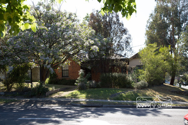
 Eltham District Historical Society Inc
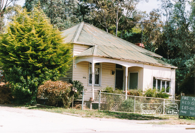
Photograph, Margaret Ball, Shillinglaw trees, site of former Shire of Eltham offices and prior to that the original site for Shillinglaw Cottage, 895 Main Road, Eltham, 1999, 1999
The adjoining block at no. 52 was not developed at the time. Since Feb 2014 (most recent Google Street View as of Jan 2018), both sites have been bulldozed and new developments built.The Margaret Ball (Pre 1960s Houses) Collection was a personal project initiated to mark the year 2000 and arose as a result of the disappearance of many pre-1960s parts of Eltham due to development. Approximately 200 pre-1960s style houses that were left in Eltham between Main Road and east to Bible Street, between Cecil Street to the north and south to Dalton Street were photographed in late 1999. Not all of the houses could be photographed; some because the garden or trees blocked the view of the house, others because of rubbish or cars were in the way, some because people were working on the house or in the gardens at the time.Colour photographic printeltham, houses, streets, margaret ball (pre 1960s houses) collection, shillinglaw trees, shillinglaw cottage, eltham shire office -
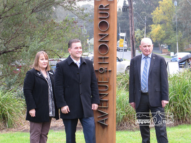 Eltham District Historical Society Inc
Photograph, Dedication of new Avenue of Honour Memorial, Main Road, Eltham, 2 June 2015
Cr Helen Coleman with Minister for Veterans, John Eren at the official opening of the Eltham Avenue of Honour markersBorn Digitalavenue of honour, war memorials, plaques, main road, eltham, helen coleman -
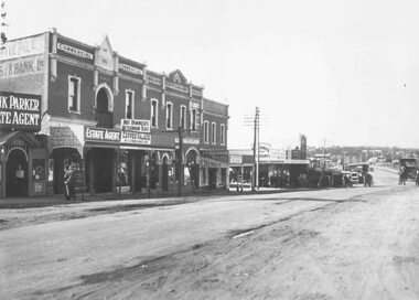
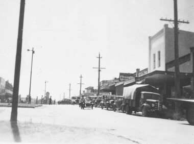
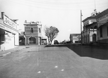 Stawell Historical Society Inc
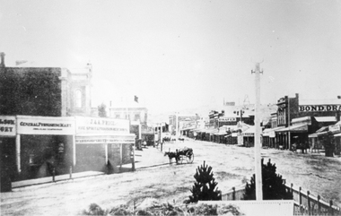
Photograph, Wimmera Street looking North from Florence Street across Main Street with Dalgety's on the Left 1947, Post Office and Post Office Hotel on right
Wimmera Street looking North from Florence Street across Main Street. 1947 Dalgety's. Two story Commercial Bank. N.W. Ledgars Boot maker. Post Office and Post Office Hotel. Post Office Hotel opened on March 31st 1875. The first licensee was granted to H.W. Richards who held it for 3 years. Some other long running licensees were Adam Holbing 1885-1892, Mrs S.B. Whitty to 1901, Elizabeth Kyhat to 1944, Harry Kuhl , 1955-1967. When Harry died, Roy West 1967-1970 when the license was surrendered. The building is now a shopping arcade. View looking North across Wimmera and Main Street Intersection. The Commercial Bank building on left and N.W. Ledgar, Bootmaker, Post Office and Post Office Hotel on the right. stawell businesses, hotel -
 Eltham District Historical Society Inc
Photograph, Main Road, Eltham South, near Eltham Park, flooded by the Diamond Creek, 30 Nov. 1934
Near Eltham Park (now known as Eltham Lower Park), floodwaters from the Diamond Creek cut off the Main road into Eltham at Bremner’s Flats (present day Wingrove Park). In the distance, left of centre, is Mr. Montieth's Ford Wagonette stranded in the floodwater near Wingrove Cottage. “On the Lower Eltham Reserve the water was nearly five feet deep across the reserve and over a mile along the road. All the week-end shops are surrounded. For over 40 years flood waters have not reached this unprecedented level.” - Advertiser, Friday November 30, 1934, p7 "Whilst we were at the shop a "tidal" wave occured . There used to be a Mr. Monteith who ran a Model T Ford bus from the Eltham Railway Station down the main street. The bus would hold seven, six seated in the back, 3 aside a seventh standing on the step on the middle of the back hanging on to two small hand rails. The bus was caught by the flood and was abandoned not far from our shop in the paddocks towards the Higher Elementary School. It was there for days and after the flood waters receded, Mr. Monteith, after removing all the mud and debris gave the engine one turn with the handle and it started first time! So the story goes! " (Doug Orford Reminiscences, 2004) The 1934 flood of the Diamond Creek and Yarra River is the highest recorded flooding in the district and set the standard for the current planning flood plain level.Black and white photograph showing the floodwater from Diamond Creek across Main Road in 1934. Left of centre shows Mr. Montieth's Ford Wagonette in the floodwater in the distancefloods, main road, eltham south, diamond creek (creek), wingrove cottage, wingrove park, bus services, bremner's flat, eltham park, ford wagonette, mr. montieth, floodwater, reminscences -
 Eltham District Historical Society Inc
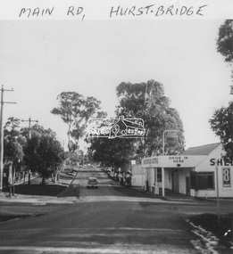
Photograph, 994 Main Road, Hurstbridge
Colour photograph of house at 994 Main Road Hurstbridgehouses, 994 main road, main road, heidelberg/kinglake road, hurstbridge -
 Stawell Historical Society Inc
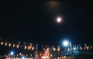
Photograph - Slide, Stawell Gift Main Street at night
Night Scene of Main Street showing flags and Lights -
 Stawell Historical Society Inc
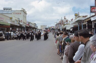
Photograph - Slide, Stawell Band Marching in Main Street
Band marching in Main Street with crowds lining the Street -
 Whitehorse Historical Society Inc.
Photograph - Strip and photocopy, Corner South Parade & Main Street, Blackburn, 1/08/1976 12:00:00 AM
strip photos of South Parade and Main Street Blackburnmain street, blackburn -
 Department of Health and Human Services
Photograph, Colanda Grounds - Main Kitchen
The Colac, Victoria-based Colanda Centre was one of the last Victorian institutions and offered disability accommodation from 1976, when it was established, until 2019, with its closure.Digitised colour photograph of the Colanda Centre main kitchen -
 Department of Health and Human Services
Photograph, Colanda grounds - main driveway gardens
The Colac, Victoria-based Colanda Centre was one of the last Victorian institutions and offered disability accommodation from 1976, when it was established, until 2019, with its closure.Digitised colour photograph of Colanda's main driveway gardens. colanda, colac, disability services, residential services, disability, digitised photograph -
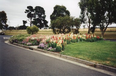
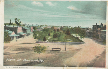 Lakes Entrance Historical Society
Postcard - Main Street gardens Bairnsdale Victoria, c1900
Colour postcard Main Street gardens Bairnsdale Victoriagardens, businesses -
 Ringwood and District Historical Society
Photograph, Maroondah Highway Central, Ringwood. Main Street shops looking east from near station entrance, c1921
Black and white photograph(2 copies- 1 large, 1 smaller)Written below photograph, "Main Street Shops". -
 Ringwood and District Historical Society
Photograph, Main Street shops looking east - Maroondah Hwy, Ringwood - 1935
Written on back of photograph, "Main Street, Ringwood". -
 Tatura Irrigation & Wartime Camps Museum
Photograph, The Goulburn-Waranga Main Channel, 1957
Taken by the photographer for Victoria State Rivers and Water Supply Commission.Sepia photograph - dry mounted on cream cardboard. Wide view of water-filled channel, trees lining each bank Large photographAbove photo - "The Goulburn Waranga Main Channel"irrigation, goulburn, waranga, victoria state rivers and water supply commission, channel -
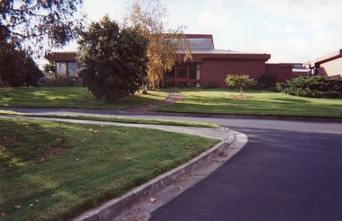
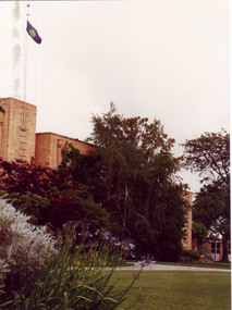 University of Melbourne, Burnley Campus Archives
Photograph - Colour print, Peter Esdale, Main Building VCAH Burnley 1991, 1991
Colour Photograph by taken by P. Esdale from the S.E. Part of the Administration Building with garden beds in front. VCAH flag flying from roof.On reverse, "Main building VCAH Burnley 1991."1991, administration building, garden view, main building, vcah flag -
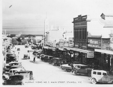 Stawell Historical Society Inc
Photograph, Murray Views, Main Street in Stawell c1950 -- Postcard, C 1950
Sister of Donor Visited Stawell in th e1950'2 When she Purchased thes Murray Views Cards. The Cards were produced for sale to touristsSet of 8 Murry Views Postcards No 1 to No 8 C. 1950Murray Views No.5 Main Street Stawell -
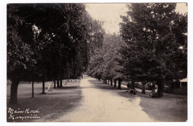 Marysville & District Historical Society
Postcard (item) - Black and white postcard, Main Road Marysville, Unknown
Postcard of early black and white photograph of the main street of Marysville in Victoria. This street is now known as Murchison Street.Postcard of early black and white photograph of the main street of Marysville in Victoria. This street is now known as Murchison Street.POST CARD PLACE/ POSTAGE/ STAMP/ HEREmarysville, victoria, murchison street, postcard, souvenir -
 Bacchus Marsh & District Historical Society
Photograph, Simon Brothers Motor Garage corner of Main Street and Grant Street c.1940s
This image shows one of the busiest intersections of Bacchus Marsh, the corner of Main and Grant Streets. The main building shown in the image is Simon Brothers Motor Service and Cycle Depot. In 1903 the Simon brothers, Herbert (Bert) and Walter began making Monarch bicycles and later Monarch motor cycles. In 1913 they moved into newly constructed premises shown in this image. The business operated as both a garage, service station and cycle depot. The business operated until 1948 when P. S. Carey brought the premises to expand his Grant Street car dealership business which was located next to the Simon Brothers garage. Black and white photograph showing Simon Brothers Motor garage Bacchus Marsh seen from the northern side of Main Street looking south west towards Grant Street. BMDHS Location: AR/R4/S2 Photo Album Jack Coe Collection, and digital image on BMDHS computer network.On reverse, "Jack Coe Collection"small businesses bacchus marsh, simon family bacchus marsh, simon brothers garage, petrol stations -
 Eltham District Historical Society Inc
Photograph, Marian Mitchell (nee Robinson), Main Road, Hurstbridge, 7 Aug 1971
Apparently the garage belonged to Peter Brock’s family for which it was locally known and referred to as “Brock’s Garage”."Main Road Hurstbridge" on front On reverse of image: Hurstbridge Main Road Aug 7 1971 Taken by Narian Mitchell (nee Robinson)"fc holden station sedan, hurstbridge, hurstbridge motors, main road, shell service station, peter brock, brock's garage -
 Stawell Historical Society Inc
Photograph, Main Street looking East from Coffee Palace area 1880
Main Street Looking East 1880 from weigh bridge area, taken from Coffee Palace verandah. Two story buildings with veranda's. Horse drawn vehicle center of image. Post office and Town Hall visible in background. Bond Drapery. J & A Price Wine Spirits. Bond Draper sign on right. Two Poppet Heads on Big Hill are the No2 North Waterloo and the Waterloo and Argyle Mines.Black and white photograph looking East along Main Street from Weighbridge area where two streets join. Horse drawn buggy in center of street with buggy. Big Hill in distance with two poppet heads just visible.stawell businesses streetscape -
 Mt Dandenong & District Historical Society Inc.
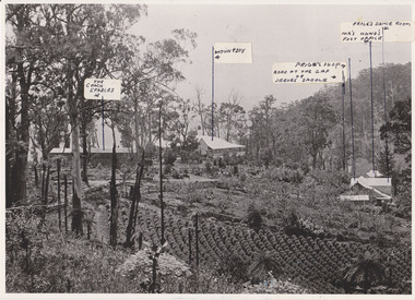
Photograph, 1908 View of the Kalorama Gap from Main Road With Labelling, 1908
Photograph with labels attached to front identifying buildings. View of the Kalorama Gap from main Road (now Ridge Road), looking across Walker's raspberry patch with Mountjoy coaching stables on the LHS and Mountjoy Guest House in centre. Price's house and shop on the RHS. This photograph has a detailed inscription on the back handwritten by John Lundy-Clarke in 1974.1908 View of the Kalorama Gap from main Road – now Ridge Road above Lot 2 of the Village Settlement. Looking across Walker’s raspberry patch with “Mountjoy” coaching stables on left. “Mountjoy” in centre. Prices house and shop on right with Hands “Beulah Tearooms” above Prices roof. On hillside beyond Hand’s is the slope now taken up by Kalorama Terrace. Walker’s well, then newly dug is in lower right hand corner below the tree fern head. Mt Kalorama is the hill top right. Track leaving Main Road left is Walker’s entrance drive.kalorama, kalorama gap, walker, beulah tea rooms, price, hand, mountjoy, mt kalorama -
 Eltham District Historical Society Inc
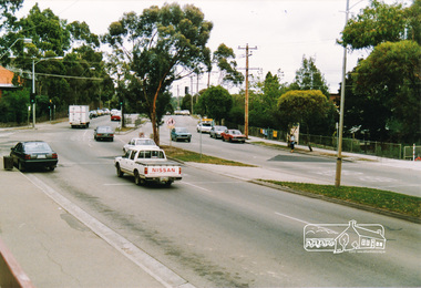
Photograph, Main Road, Eltham near Dudley Street
Three colour photographs of Main Road, Eltham at Dudley Streetmain road, dudley street, eltham -
 Eltham District Historical Society Inc
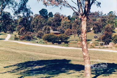
Photograph, Town Park, Main Road, Eltham
Colour photograph of Eltham Town Park near Main Roadmain road, eltham, twon park -
 Stawell Historical Society Inc
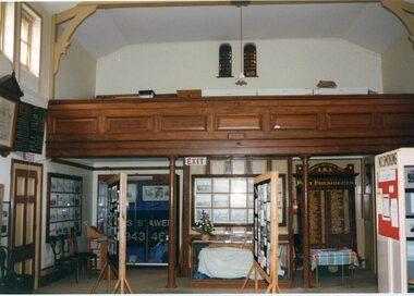
Photograph, Interior of the old courthouse (Main Room)
2 colour Photographs of the Interior of the old courthouse (Main Room)stawell historical society, old court house -
 Stawell Historical Society Inc
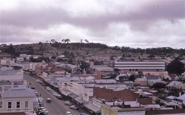
photograph - Slides, Ian McCann, Main Street Looking towards Bg Hill, 1976 - 1984
Colour Photograph of Main Street looking towards Big Hill