Showing 1681 items
matching main creek
-
 Eltham District Historical Society Inc
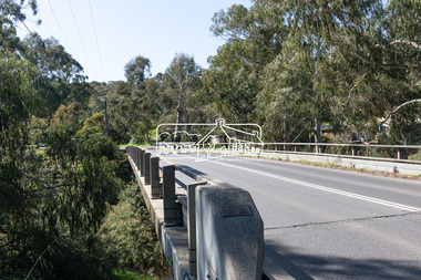
Photograph, Peter Pidgeon, Manna Gum, Main Road Bridge, Eltham South, 8 Sep. 2021
This significant tree located near the Main Road Bridge over the Diamond Creek at Eltham dates back to approximately 1870-1880. Though dead now, its trunk has been left as a wildlife habitat. The original timber bridge over the Diamond Creek was built around 1840. It was destroyed by floodwaters in October 1923. A temporary bridge was rigged up but further damaged in April 1924. A new concrete bridge was built and opened in October 1926. The bridge decking was widened along with Main Road to Dalton Street by the Road Construction Authority in 1984., The uygraded bridge was opened in October 1984, 78 years after its original opening.These trees are not only significant for the natural environment but also present a navigational beacon back in time as the environmental landscape is developed around them.Born Digitaleltham south, main road bridge, manna gum, significant tree -
 Eltham District Historical Society Inc
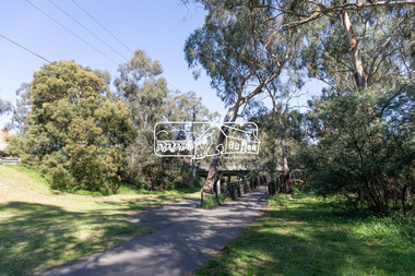
Photograph, Peter Pidgeon, Manna Gum, Main Road Bridge, Eltham South, 8 Sep. 2021
This significant tree located near the Main Road Bridge and Diamond Creek Trail footbridge over the Diamond Creek at Eltham dates back to the early 1900s. The original timber bridge over the Diamond Creek was built around 1840. It was destroyed by floodwaters in October 1923. A temporary bridge was rigged up but further damaged in April 1924. A new concrete bridge was built and opened in October 1926. The bridge decking was widened along with Main Road to Dalton Street by the Road Construction Authority in 1984., The uygraded bridge was opened in October 1984, 78 years after its original opening.These trees are not only significant for the natural environment but also present a navigational beacon back in time as the environmental landscape is developed around them.Born Digitaleltham south, main road bridge, manna gum, significant tree, diamond creek trail -
 Eltham District Historical Society Inc
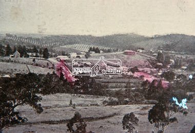
Slide, View overlooking Diamond Creek, 1907
View overlooking Diamond Creek to the northeast, most likely from near St John's Church, 190735 mm colour positive transparency of a newsprint image taken c.1970 Mount - Kodak Kodachrome Card13diamond creek township -
 Eltham District Historical Society Inc
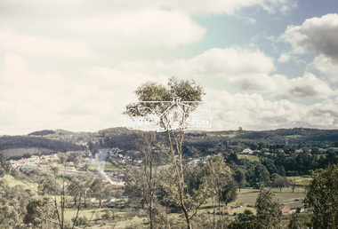
Slide, View overlooking Diamond Creek, 1970
View overlooking Diamond Creek to the northeast, most likely from near St John's Church, 197035 mm colour positive transparency of a newsprint image taken c.1970 Mount - Kodak Kodachrome Card27diamond creek township -
 Eltham District Historical Society Inc
Slide, Pills Cottage, Heidelberg-Kinglake Road, Cottles Bridge, Vic, c.1970
Pills Cottage about halfway from Cottles Bridge to St Andrews near 1575 Heidelberg-Kinglake Road, St Andrews. William John "Bill" Pill was born on 19th June 1894 at Diamond Creek He was brutally murdered on 21st December 1958 age 64, in his cottage. His father was John Henry Pill, born 24 November 1856, Lalone, Perranzabuloe, Cornwall, England, He died 21 December 1930 at Cottles Bridge, His mother was Jessie Ann Whatmough, born 6th June 1870. She died 21 August 1921. William John "Bill '' Pill, grew tomatoes on his rich two and a half acres. In 2024 his second cousin Steve Whatmough recalled visiting Bill in 1957 with his parents (Eric and Nancy Whatmough) and Bill showing them his tomatoes. He had a very large aeroplane propeller set up at one end on his tomato crop. He would run the propeller on frosty mornings to keep away the frost damage. His tomatoes would ripen early and would receive a premium price for them. The cottage consisted of two buildings. The one closest in the right side of the photo was the kitchen. The second building that also has a chimney was his bedroom and living room.35 mm colour positive transparency Mount - Agfacolor Service (Blue)heidelberg-kinglake road, pills cottage, st andrews, william john pill, bill pill, john henry pill, jessie ann pill (nee whatmough), market gardener, murder, cottles bridge (vic.), tomato farm, mount - agfacolor service (blue), scan - 35mm positive -
 Eltham District Historical Society Inc
Slide, Pills Cottage, Heidelberg-Kinglake Road, Cottles Bridge, Vic, c.1970
Pills Cottage about halfway from Cottles Bridge to St Andrews near 1575 Heidelberg-Kinglake Road, St Andrews. William John "Bill" Pill was born on 19th June 1894 at Diamond Creek He was brutally murdered on 21st December 1958 age 64, in his cottage. His father was John Henry Pill, born 24 November 1856, Lalone, Perranzabuloe, Cornwall, England, He died 21 December 1930 at Cottles Bridge, His mother was Jessie Ann Whatmough, born 6th June 1870. She died 21 August 1921. William John "Bill '' Pill, grew tomatoes on his rich two and a half acres. In 2024 his second cousin Steve Whatmough recalled visiting Bill in 1957 with his parents (Eric and Nancy Whatmough) and Bill showing them his tomatoes. He had a very large aeroplane propeller set up at one end on his tomato crop. He would run the propeller on frosty mornings to keep away the frost damage. His tomatoes would ripen early and would receive a premium price for them. The cottage consisted of two buildings. The one closest in the right side of the photo was the kitchen. The second building that also has a chimney was his bedroom and living room.35 mm colour positive transparency Mount - Agfacolor Service (Blue)bill pill, cottles bridge (vic.), heidelberg-kinglake road, jessie ann pill (nee whatmough), john henry pill, market gardener, mount - agfacolor service (blue), murder, pills cottage, scan - 35mm positive, st andrews, tomato farm, william john pill -
 Eltham District Historical Society Inc
Slide, Construction of Eltham Town Park, 22 Feb 1974
Construction of Eltham Town Park, later renamed Alistair Knox Park. In the foreground is where the Diamond Creek Trail runs along the creek and in the distance is the Bridge Street bridge.35 mm colour positive transparency Mount - Agfacolor Service (Blue)alistair knox park, eltham town park, bridge street bridge -
 Eltham District Historical Society Inc
Slide, Construction of Eltham Town Park, 22 Feb 1974
Construction of Eltham Town Park, later renamed Alistair Knox Park. View looking towards Bridge Street and shows the Diamond Creek and formation of the Diamond Creek Trail.35 mm colour positive transparency Mount - Agfacolor Service (Blue)alistair knox park, eltham town park, bridge street bridge, diamond creek -
 Eltham District Historical Society Inc
Slide, Maroondah Aqueduct, Research, Victoria, 22 Mar. 1981
An inspection tour of the Maroondah Aqueduct was undertaken by the Shire of Eltham Historical Society on Sunday, March 22nd, 1981, commening where the aqueduct crosses Main Rd., Research, just below Eltham College. The Maroondah Aqueduct was part of Melbourne’s water supply system. It carried water over the 66 km from the Maroondah Reservoir on the Watts River at Healesville to the Preston Reservoir. Of this length, 41 km were open channel, 10 km, tunnel through hills and 15 km in 14 inverted siphons across stream valleys. The route of the aqueduct is north of Tarrawarra and Yarra Glen, along the Yarra escarpment south of Christmas Hills and crossing Watsons Creek into the present Shire of Eltham near Henley Rd. The eastern part of the route lies entirely within the former boundaries of the shire. The aqueduct passes south of Kangaroo Ground to Research and crosses the Diamond Creek by siphon at Allendale Rd., Eltham North. It then extends to Reservoir via St. Helena, Greensborough North and Bundoora. Water first flowed through the aqueduct in February 1891 when it was fed by a diversion weir on the Watts River. Records of the building of the aqueduct indicate that it was a significant construction achievement. The present Maroondah Reservoir was completed in 1927 and the aqueduct was enlarged at that time to take increased flows. About 1971 the section of the aqueduct through and north of Research was replaced by a large pipe and that section of the channel is now unused. The channel has remained largely intact (unlike sections at Greensborough and Bundoora where long lengths of the disused aqueduct have been demolished or filled in). The M.M.B.W. relinquished control of the disused aqueduct reserve which is crown land and the Shire of Eltham took control of this section of the reserve as a linear park. The Maroondah Aqueduct is considered to be an important historic structure, not just to the local area but to the metropolitan area generally. It is considered important to preserve substantially intact long lengths of the disused aqueduct, together with its bridges and other associated structures. 35 mm colour positive transparency (1 of 5) Mount - Agfachrome Agfa CS System black 8 dotsactivities, heritage excursion, maroondah aqueduct, research (vic.), shire of eltham historical society -
 Eltham District Historical Society Inc
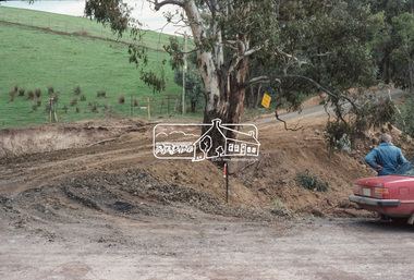
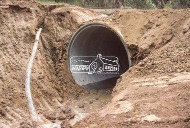
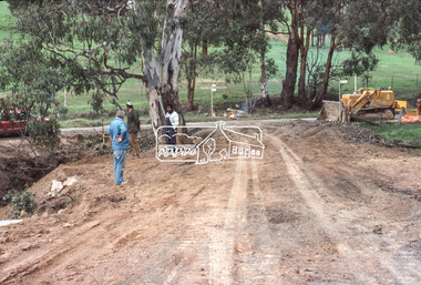
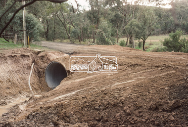
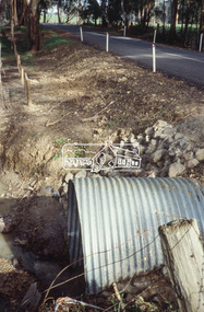
Slide, Culvert construction: Greens Road, Arthurs Creek, 19 Jun. 1981
Culvert construction / drainage operations undertaken throughout the Shire of Eltham - Greens Road near intersection of Cottlesbridge-Strathewen Road, Arthurs Creek35 mm colour positive transparency (1 of 4) Mount - Kodak Kodachrome Cardculvert, infrastructure, roadworks, arthurs creek, cottles bridge-strathewen road, greens road -
 Eltham District Historical Society Inc
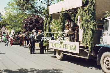
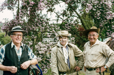
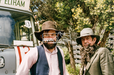
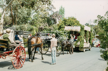
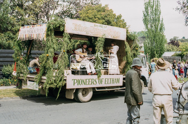
Slide, Grand Parade, Eltham Community Festival, 17 Oct. 1981
The 1981 Eltham Community Festival was held from 16th to 18th October, with the festival parade being held on Saturday 17th. In recent years the Society had participated in the parade and a display for the festival, winning prizes for the Society’s float in 1979, 1980 and again in 1981 with a prize for the best effort by a local group, donated by Bob Clarke's Menswear. Peter Quirke provided the use of his truck as a float. Peter had formerly operated his fruiterer's business at Research and Diamond Creek and in 1981 opened a shop in the Eltham Village Arcade. Joh Ebeli, with assistance from other members decorated the float. Members of the Victorian Folk Music Club accompanied the Society on the float and their music helped create the appropriate mood. A new feature of the Society’s 1981 parade entry was the inclusion of horse drawn vehicles owned and driven by the Hennel family of Hurstbridge, which added to a highly successful day. Society member and long-time Eltham resident, Jock Read also won an award for the “Best Eltham Theme.” Jock and his horse were a feature of Eltham parades for many years and he also established a local tradition in leading Anzac Day parades. 35 mm colour positive transparency (1 of 5) Mount - Agfachrome Agfa CS System black 8 dotseltham festival, parade, parade floats, pioneers of eltham, shire of eltham historical society, cecil street, victorian folk music club -
 Eltham District Historical Society Inc
Slide, Grand Parade, Eltham Community Festival, 17 Oct. 1981
The 1981 Eltham Community Festival was held from 16th to 18th October, with the festival parade being held on Saturday 17th. In recent years the Society had participated in the parade and a display for the festival, winning prizes for the Society’s float in 1979, 1980 and again in 1981 with a prize for the best effort by a local group, donated by Bob Clarke's Menswear. Peter Quirke provided the use of his truck as a float. Peter had formerly operated his fruiterer's business at Research and Diamond Creek and in 1981 opened a shop in the Eltham Village Arcade. Joh Ebeli, with assistance from other members decorated the float. Members of the Victorian Folk Music Club accompanied the Society on the float and their music helped create the appropriate mood. A new feature of the Society’s 1981 parade entry was the inclusion of horse drawn vehicles owned and driven by the Hennel family of Hurstbridge, which added to a highly successful day. Society member and long-time Eltham resident, Jock Read also won an award for the “Best Eltham Theme.” Jock and his horse were a feature of Eltham parades for many years and he also established a local tradition in leading Anzac Day parades. 35 mm colour positive transparency (1 of 5) Mount - Agfachrome Agfa CS System black 8 dotseltham festival, parade, parade floats, pioneers of eltham, shire of eltham historical society, cecil street, garnet burges, jack hodson, jock read -
 Eltham District Historical Society Inc
Slide, Grand Parade, Eltham Community Festival, 17 Oct. 1981
The 1981 Eltham Community Festival was held from 16th to 18th October, with the festival parade being held on Saturday 17th. In recent years the Society had participated in the parade and a display for the festival, winning prizes for the Society’s float in 1979, 1980 and again in 1981 with a prize for the best effort by a local group, donated by Bob Clarke's Menswear. Peter Quirke provided the use of his truck as a float. Peter had formerly operated his fruiterer's business at Research and Diamond Creek and in 1981 opened a shop in the Eltham Village Arcade. Joh Ebeli, with assistance from other members decorated the float. Members of the Victorian Folk Music Club accompanied the Society on the float and their music helped create the appropriate mood. A new feature of the Society’s 1981 parade entry was the inclusion of horse drawn vehicles owned and driven by the Hennel family of Hurstbridge, which added to a highly successful day. Society member and long-time Eltham resident, Jock Read also won an award for the “Best Eltham Theme.” Jock and his horse were a feature of Eltham parades for many years and he also established a local tradition in leading Anzac Day parades. 35 mm colour positive transparency (1 of 5) Mount - Agfachrome Agfa CS System black 8 dotseltham festival, parade, parade floats, pioneers of eltham, shire of eltham historical society, cecil street, russell yeoman, bruce ness -
 Eltham District Historical Society Inc
Slide, Grand Parade, Eltham Community Festival, 17 Oct. 1981
The 1981 Eltham Community Festival was held from 16th to 18th October, with the festival parade being held on Saturday 17th. In recent years the Society had participated in the parade and a display for the festival, winning prizes for the Society’s float in 1979, 1980 and again in 1981 with a prize for the best effort by a local group, donated by Bob Clarke's Menswear. Peter Quirke provided the use of his truck as a float. Peter had formerly operated his fruiterer's business at Research and Diamond Creek and in 1981 opened a shop in the Eltham Village Arcade. Joh Ebeli, with assistance from other members decorated the float. Members of the Victorian Folk Music Club accompanied the Society on the float and their music helped create the appropriate mood. A new feature of the Society’s 1981 parade entry was the inclusion of horse drawn vehicles owned and driven by the Hennel family of Hurstbridge, which added to a highly successful day. Society member and long-time Eltham resident, Jock Read also won an award for the “Best Eltham Theme.” Jock and his horse were a feature of Eltham parades for many years and he also established a local tradition in leading Anzac Day parades. 35 mm colour positive transparency (1 of 5) Mount - Agfachrome Agfa CS System black 8 dotseltham festival, parade, parade floats, pioneers of eltham, shire of eltham historical society, cecil street, victorian folk music club -
 Eltham District Historical Society Inc
Slide, Grand Parade, Eltham Community Festival, 17 Oct. 1981
The 1981 Eltham Community Festival was held from 16th to 18th October, with the festival parade being held on Saturday 17th. In recent years the Society had participated in the parade and a display for the festival, winning prizes for the Society’s float in 1979, 1980 and again in 1981 with a prize for the best effort by a local group, donated by Bob Clarke's Menswear. Peter Quirke provided the use of his truck as a float. Peter had formerly operated his fruiterer's business at Research and Diamond Creek and in 1981 opened a shop in the Eltham Village Arcade. Joh Ebeli, with assistance from other members decorated the float. Members of the Victorian Folk Music Club accompanied the Society on the float and their music helped create the appropriate mood. A new feature of the Society’s 1981 parade entry was the inclusion of horse drawn vehicles owned and driven by the Hennel family of Hurstbridge, which added to a highly successful day. Society member and long-time Eltham resident, Jock Read also won an award for the “Best Eltham Theme.” Jock and his horse were a feature of Eltham parades for many years and he also established a local tradition in leading Anzac Day parades. 35 mm colour positive transparency (1 of 5) Mount - Agfachrome Agfa CS System black 8 dotseltham festival, parade, parade floats, pioneers of eltham, shire of eltham historical society, cecil street, victorian folk music club -
 Eltham District Historical Society Inc
Photograph, Watson's Creek Antiques, Eltham-Yarra Glen Road, c.May 1988
35mm colour positive transparency (1 of 25) Mount - Kodak EktachromeProcess Date MAY 88Meltham-yarra glen road, watson's creek antiques -
 Eltham District Historical Society Inc
Slide - Photograph, Eltham Town Park, c.May 1988
In 1981 the Shire of Eltham Historical Society was asked by the Victorian Place Names Committee to comment on a proposal by the Shire of Eltham to assign names to parklands in Eltham as follows:- "Eltham Common" - the area between the municipal offices, Main Road, the Eltham railway -line, and Panther Place and containing Shillinglaw Cottage. The Shire has advised that this name has been used locally for the site since about 1975. "Alistair Knox Park" - the area bounded by the Eltham railway -line, Panther Place, Main Road, Bridge Street, and Susan Street, and through which flows the Diamond Creek. The area has been known locally as "Eltham Town Park" The proposed name "Alistair Knox Park" had created some local controversy with a number of reversals of the Council's decision and letters to the local paper both for and against the proposal. The society was reluctant to be drawn into this controversy particularly as there were known to be members with strong views both for and against the proposed name. The society appreciated the work done by Alistair Knox both in the formulation of the park concept and in its development but because of the controversy generated by the proposed naming and also because of the wide general use of the park by the public·, the name Eltham Town Park was felt more appropriate. The society noted that there was no outstanding historical associations with the land comprising the park which would warrant naming the park after any particular person, place or event. No objection was raised to the Eltham Common proposal as set-out above. The decision was made in the knowledge that Alistair Knox had been associated with the society over many years and was a prominent figure in the recent history of Eltham. He was regarded as a key figure in the environmental building movement and in particular was renowned for his use of mud bricks as a building material. He served as a councillor of the Shire of Eltham from 1971-1975, his final year as Shire President. It was during these years that the proposals to create the park in its present form were shaped and Alistair played a leading part in the decision to make it a landscaped passive recreational park rather than a sporting area. The parklands comprise a section of the Diamond Creek valley. The creek itself flows through the centre of the area which is overlooked by steep hills on each side. The parks form part of the land purchased from the Crown in 1851 by J.M. Holloway and then subdivided into allotments and called "Little Eltham". While most of the area was subdivided into residential lots the creek valley was subdivided into lots suitable for small farms. Some further subdivision took place over the years and the whole of the parks now comprises eight separate titles. A list of some of the former owners has been compiled but exhaustive research on all owners has not been carried out. The ownership of one parcel has been traced back to when it was purchased from Holloway by John Hicks Petty in 1874, long after it was subdivided. Other families owning land within the area over the years included Lyon, Rees, Clark, Waterfall, Carrucan, Graham, Hill and Morant. The character of the valley area has remained rural while development occurred on each side. Early photos show the area as orchard and grazing land. In 1901 the railway was constructed through the area resulting in the timber trestle bridge across the Diamond Creek. which is an important feature of the park landscape. A memorial obelisk to the Eltham servicemen killed in World War 1 was erected at the south eastern corner of the park. The site is now within the intersection of Main Road and Bridge Street and the memorial was shifted in the 1950s to the Eltham R.S.L. clubrooms. Following the financial failure of the local sub-branch, the memorial obelisk was again relocated to the Eltham War Memorial building precinct in 2011. During the early 1960's the Council started purchasing the land which now comprises the parks. In the late 1960's the area to the east of the Diamond Creek was used as a garbage tip and filled above the flood plain of the creek. When this area was filled the tip was transferred to the west side of the creek. From the early 1970's the area has been progressively developed as a park for passive recreation with ornamental lakes, extensive tree planting and landscaping. The character of the valley before the days of the tip has been recreated and this has earned a Landscape classification from the National Trust, an unusual honour for a man-made landscape. The parks are not only attractive in appearance. The large number of people using them, particularly at weekends and holidays is evidence of their popularity and the foresight and careful planning of local residents, Councillors and Council Staff. 35mm colour positive transparency (1 of 23) Mount - Kodak EktachromeProcess Date MAY 88Meltham, main road, alistair knox park, eltham town park -
 Eltham District Historical Society Inc
Slide - Photograph, Dalton Street Lane, Eltham, c. Feb. 1989
35mm colour positive transparency (1 of 8) Mount - Agfa CS System grey 8 dotsdalton street, diamond creek trail, eltham -
 Eltham District Historical Society Inc
Slide - Photograph, Dalton Street Lane, Eltham, c.Mar. 1989
35mm colour positive transparency (1 of 28) Mount - Kodak KodachromeProcess Date MAR 89Meltham, dalton street, diamond creek trail -
 Eltham District Historical Society Inc
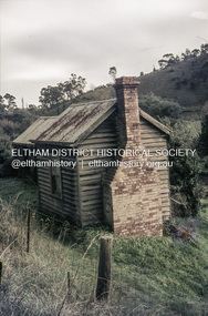
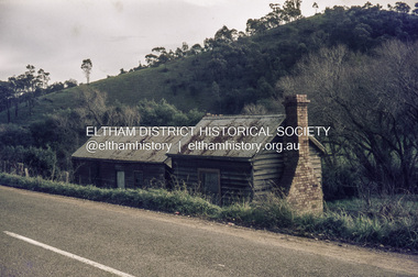
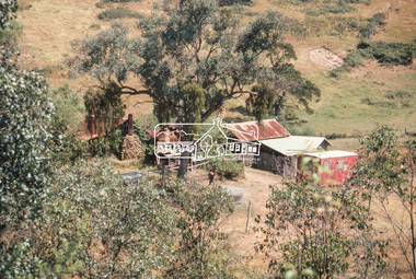
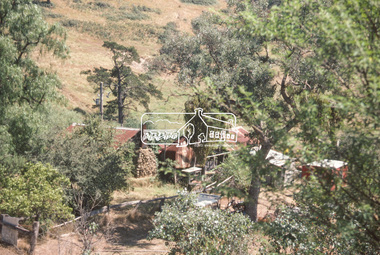
Slide - Photograph, Birch Cottage, Yarra Glen Road, Christmas Hills, c.Mar. 1989
Historical property that sits beside Watsons Creek. In 1903 a Miners Right of one acre in area was granted to Edwin Samuel Birch. In 1907 Birch applied to purchase this land but was unable to because it was part of the creek reserve. The house existed at that time. Birch died in 1932 and his daughter Honor Mary Birch was granted a permit to occupy the residence. The future of the cottage remains precarious because of its location on Crown land. In 2007 the Andrew Ross Museum began a campaign to ensure its preservation - NL18235mm colour positive transparency (1 of 28) Mount - Kodak KodachromeProcess Date MAR 89Mbirch cottage, christmas hills, smiths gully, watson's creek, yarra glen road -
 Eltham District Historical Society Inc
Slide - Photograph, Cottlesbridge-Strathewan Road, Arthurs Creek, c.June 1990
35mm colour positive transparency (1 of 36) Mount - Agfa CS System grey 8 dotsroads, strathewan road, greens road, arthurs creek -
 Eltham District Historical Society Inc
Slide - Photograph, Cottlesbridge-Strathewan Road, Arthurs Creek, c.June 1990
35mm colour positive transparency (1 of 36) Mount - Agfa CS System grey 8 dotsroads, strathewan road, greens road, arthurs creek -
 Eltham District Historical Society Inc
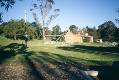
Slide - Photograph, Shillinglaw Cottage, Eltham Common, Panther Place, Eltham, 27 May 1990
Local Cemetery Excursion Sunday 27 May 1990 departed Eltham Shire Office at 9.30am and finish mid afternoon. Visits to Eltham , Kangaroo Ground, Queenstown (Smiths Gully), Nillumbik (Diamond Creek), St Katherines (St Helena) Hurst family graves at Hurstbridge and a little known early cemetery at Grteensborough. Attended by 20 members. In each case we were introduced to the cemetery with a brief talk. At Eltham, Frank Burgoyne gave us the benefit of his knowledge as a member of the cemetery trust and at Kangaroo Ground, Bruce Ness spoke in a similar capacity. The lunch stop was at Hurstbridge where we visited the Hurst family graves. The President of Nillumbik Historical Society, Jock Ryan, joined us at the Nillumbik (Diamond Creek) cemetery. He travelled on to St Katherines, St Helena, where he talked on the history of the church and cemetery.35mm colour positive transparency (1 of 25) Mount - Kodak EktachromeProcessing Date Code Jun 90Mshillinglaw cottage, eltham common, panther place, eltham, activities, shire of eltham historical society, cemetery excursion