Showing 3152 items matching "miles"
-
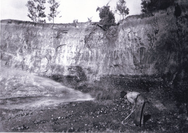
 The Beechworth Burke Museum
Photograph, 1920 - 1930
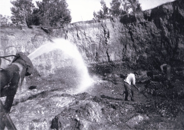
Taken between circa 1920 - 1930 this photograph depicts a Hydraulic water jet in the foreground and a man dressed in dark trousers, a white long sleeved shirt and broad-brimmed workers hat digging around in the Three Mile Mine at Barramutha. The mine was an important gold resource and was typically mined using a method known as hydraulic sluicing whereby high powered water jets are used to dislodge rock or move sediment. The remaining water sediment slurry is directed through sluice boxes to remove the gold. The Beechworth mining district was one of six mining districts established by the governor-in-council on 4th of January 1858 under the provisions of An Act for Amending the Laws Relating to the Goldfields (21 Vic no. 32).This photograph shows cultural and research value into the historical methods of hydraulic sluicing in the Beechworth mining disctrict. It also shows the evolution of the mining methods and has potential for understanding future engineering endeavors in the context of victorian mine goldfields.Black and White rectangular photograph printed on matte photographic paper. Reverse: Copied from original on loan from Webb (QLD)/ Donated Nov 2009/ Barnawatha Three Mile Mine c1920-1950/ Owned by Plain Bros then Parkinsons/ Managed by John Weir, Peter Jenson, Jack Cox/ Slicing. three mile creek, three mile goldfields, three mile beechworth, goldfields, #beechworth, hydraulic mining, hydraulic sluice, burke museum -
 Ringwood and District Historical Society
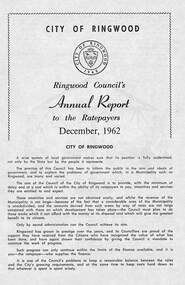
Pamphlet, F.P. Dwerryhouse, Town Clerk and Treasurer, Ringwood Council's Annual Report To The Ratepayers (December 1962), 1962
City of Ringwood community information report issued December 1962, including financial summary and sections covering Valuations, Private Street Construction, Other New Works, Sewerage, Planning Scheme, Annual Special Clearance of Refuse, Elderly Citizens' Village, Elderly Citizens' Clubrooms, Fire Hazards, and list of Council Representatives.Vale - ex-Cr. A.T. Miles, Mr. A.F.B. Long, Mr. F.R. Lucas.rinx -
 Ringwood and District Historical Society
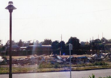
Photograph, Ringwood Bowls Club- Demolition of old Club and greens, 1997
Coloured photographPhotograph shows piled up rubbish of demolished building of old Club in Miles Avenue. -
 Ringwood and District Historical Society
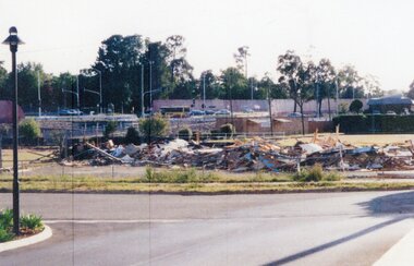
Photograph, Ringwood Bowls Club- Demolition of old Club and greens, 1993
Coloured photographPhotograph shows piled up rubbish of demolished building of old Club in Miles Avenue. -
 Clunes Museum
Photograph - PHOTOGRAPHS
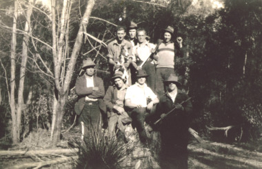
Two laminated black and white photographs of groups of men in front of what appears to be at mine site..1 on Reverse; McClean great grandfather was Bates .2 Location "Mile Creek" sawmillbates, afghan -
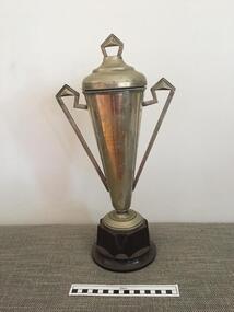 Geelong Cycling Club
Trophy, 1940
Road races have always been very popular with cyclists from the 1920s onwards.This trophy highlights the significance of this Road Race to the Club.Silver plated trophy with a lid and decorative arms on brown bakelite pedestal. The trophy is in Art Deco style.Deans Marsh/2-3-40/2 Miles Race/Won by/O. Phipps/deans marsh; 2-3-40; 2 miles race; won by; o. phipps; -
Tatura Irrigation & Wartime Camps Museum
Folder, Quobba Station
Folder put together for Tatura Historical Society and Museum.Folder describing the beaching of survivors of the Kormoran at Quobba Station near Carnarvon WA and relevant history. Photos included.17 miles well and shore. Quobba Station north north west of Carnarvon WA -
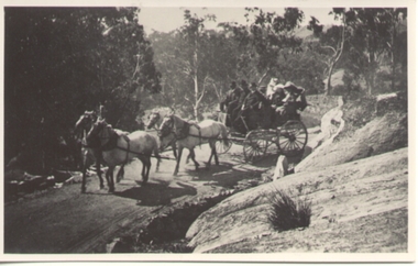 Ballarat Tramway Museum
Photograph - Black & White Photograph/s, c1900
Black and white photograph of a horse drawn coach with four horses and 6 people on Bright to Mount Buffalo road. Early 1900's?On rear in red ink "Bright to Mt Buffalo and return, 22 miles each way"trams, tramways, horse drawn vehicle -
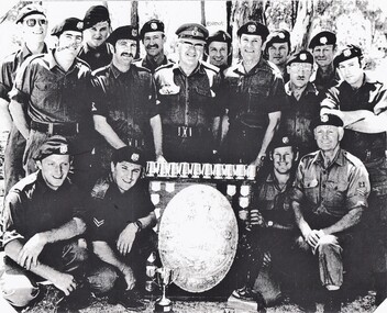 8th/13th Victorian Mounted Rifles Regimental Collection
Photograph
8/13 Victorian Mounted Rifles also won trophy in 1977. The 8th/13th Victorian Mounted Rifles was raised as a regiment of the Royal Australian Armoured Corps on 1 May 1948 with Headquarters in Melbourne and squadrons in Sale, Benalla/Wangaratta and Albury. In 1955 Regimental Headquarters moved to Wangaratta and a second squadron was located at Albury. The Sale squadron transferred to 4th/19th Prince of Wales’s Light Horse. In 1977 8/13 VMR Regiment was reduced to an independent squadron A Squadron 8th/13th Victorian Mounted Rifles and in 1991 was linked with 4th/19th Prince of Wales’s Light Horse forming the VMR Squadron of that regiment. Photocopy of black and white photo of Shooting Team of 8/13 Victorian Mounted Rifles with the 3rd Division Shield and other trophies, circa 1976. Some members are identified by notation of photograph." Cameron, Ealch, Jackle (sic), Peacock, Ter Haar, Hicks, McDonald, Miles, Armond. " -
 The Beechworth Burke Museum
Photograph, Circa 1920 - 1950
Taken between circa 1920 - 1950 this photograph depicts a man dressed in dark trousers, a white long sleeved shirt and broad-brimmed workers hat digging around in the Three Mile Mine at Barramutha. The mine was an important gold resource and was typically mined using a method known as hydraulic sluicing whereby high powered water jets are used to dislodge rock or move sediment. The remaining water sediment slurry is directed through sluice boxes to remove the gold. The Beechworth mining district was one of six mining districts established by the governor-in-council on 4th of January 1858 under the provisions of An Act for Amending the Laws Relating to the Goldfields (21 Vic no. 32). This photograph shows historic and research value into the historical methods of hydraulic sluicing in the Beechworth mining disctrict. It also shows the evolution of the mining methods and has potential for understanding future engineering endeavors in the context of victorian mine goldfields. Black and white rectangular photograph printed on matte photographic paper.Reverse: 7597.3/ Copied from original on loan from Webb (QLD)/ Donated Nov 2009/ Barnawatha Three Mile Mine 1920-1950/ Owned by Plain Bros then Parkinsons/ Managed by John Weir, Peter Jenson, Jack Cox/ Slicing. three mile creek, three mile goldfields, three mile beechworth, goldfields, #beechworth, hydraulic mining, hydraulic sluice, burke museum -
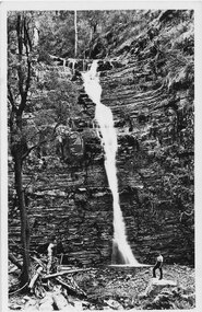 Halls Gap & Grampians Historical Society
Postcard - Sepia, C 1930s
One postcard has an unsigned message on the back; not addressed and not postmarked: "These falls we did on the round trip of 16 miles on the Tuesday. They are very pretty and have more water flowing than what is seen in the picture. They can be seen clearly from the road." * all three postcards held are originals.Post Card shows Silverband Falls with male standing on rock in foregroundFront bottom: "The Rose Series P.619, Silverband Falls, The Grampians Vic". Hand Written message on back: "These falls we did on the round trip of 16 miles on the Tuesday They are very pretty and have more water flowing than what is seen in the picture. They can be seen clearly from the road.". Back: "Post Card, the "Rose Series De Luxe. A Real Photograph Produced in Australia".scenery, silverband falls -
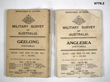 Bendigo Military Museum
Map - MAPS, GEELONG & ANGLESEA, 1928 - 1929
J.W. Swatton, Refer to Cat 6719.2P1. Military Survey map of Australia - Geelong, Vic. One inch to One mile - the map is in colour print. The two outer covers are cardboard, the map then opens up in a multifold manner. Date June 1928 2. Military Survey map of Australia - Anglesea, Vic. One inch to one mile - the map is in colour print. The two outer covers are cardboard. The map then opens up in a multi fold manner. Date March 1929.anglesea, military survey maps, geelong, victoria, passchendaele barracks trust -
Ringwood and District Historical Society
Newspaper - Newspaper Cuttings, Ringwood Memorial Clock Tower, 1928-1929
Several newspaper cuttings concerning the Ringwood Memorial Clock Tower: 3 pages of A4 with approx 8 cuttings copied. +Additional Keywords: Miles (Cr);McCaskill (Cr); MacKindlay (Cr) -
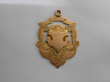 Bendigo Historical Society Inc.
Medal - CHARLES EDWIN HUNT COLLECTION: MEDAL, 1895-1896
Rose gold coloured Medal won by C E Hunt of Ramblers C.C. for 25 and 50 mile Interclub Championship 1895-96. Presented by Louis Herman1897-8. Has Hallmark. -
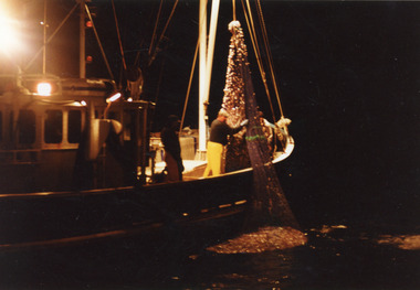 Lakes Entrance Historical Society
Photograph - Southern Hunter, 1991 c
Photo taken from Minawie|At this time Southern Hunter owned by Ted Jones, Skipper Darren Jones.|Minawie owned by Wayne SmithColour photograph of fishing net containing four tons of school whiting being hauled aboard a fishing boat, the Southern Hunter off Three Mile Beach, Wilson Promontory Victoriafishing industry, ships and shipping, ocean -
 Lakes Entrance Historical Society
Photograph - The 4 Mile Camp Old Buchan Road, Buchan Victoria, 1935-36
Black and white photograph of eight bush workers Charles Pettman with a dog posed in a bush setting at the Four Mile Old Buchan Road East Gippsland Victoria. Names on second photoworkmen, engineering, government services -
 Ringwood and District Historical Society
Photograph, Laying foundation stone, Ringwood Town Hall - 1927, 1936
Black and white photographs (3 copies- 2 large mounted on heavy cardboard, 1 smaller)Written on back of one copy: " Mayor A.T. Miles & VIP's at laying of Foundation Stone of Town Hall, 1927. Original Councillors on platform- A.T. Miles, J.B. McAlpin, W. McKinlay, A. Blood, J.K. McCaskill, R. Wilkins." Written on back of small copy: Laying foundation stone, Ringwood Town Hall, by Cr. A.T. Miles, Mayor." -
Ringwood and District Historical Society
Booklet - Souvenir, Mail' Print, Souvenir booklet - Laying of Foundation Stone of Ringwood Town Hall, Whitehorse Road, Ringwood - 1927, 1927
Book produced on the occasion of laying the foundation stone of the new Ringwood town hall 1927.Booklet - Souvenir of the Laying of the Foundation Stone of the New Municipal Chambers, Whitehorse Road, Ringwood, on Saturday 19th February, 1927, by the mayor (Cr. A. Temple Miles, J.P.).; Cost of Town Hall 6,000 Pounds. +Additional Keywords: Miles, A. Temple / Leith, A C Architect / Roberts, J / McAlpin J B / MacKindlay, W / Blood, A / Wilkins, R G / Long, A F B / Lucas, F R / Jenkin, W T / Langley, A T -
Ringwood and District Historical Society
Book, Red Cross members, Book containing details of Red Cross training during the 1940s. The book contains a newspaper clipping re 'Red Cross Work at Ringwood', 1940s
The book contains details of training received by individuals during the war years. The training includes First Aid, Home Nursing, Cookery, Catering, Anti Gas,Transport, Life Saving, Drill, Sewing, Blood Transfusions.Book containing details of Red Cross training during the 1940s. The book contains a newspaper clipping re 'Red Cross Work at Ringwood'. +Additional Keywords: Miles, AT / McAllister / Palmer / Parker / Hewitt -
 Victorian Aboriginal Corporation for Languages
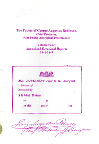
Book, Ian D Clark, The papers of George Augustus Robinson, Chief Protector, Port Phillip Aboriginal Protectorate : volume four : annual and occasional reports : 1841-1849, 2001
This is a collection of Official Reports from the Chief Protector of Aborigines. It includes expedition reports to the Western Interior, 1841, a journey of 1,100 miles to the tribes of the North West and Western Interior, 1845 and Annual Reports.document reproductionsport phillip protectorate, george augustus robinson, western district, noorat, lake boloke, lake bolac, lake corangemite, portland, koroit, koonong wootong, burrumbeep, tarecurrumbeet, wimmera, lake hindmarsh, rivoli bay, mount gambier, murray river, swan hill, goulburn, loddon, mount rouse -
Whitehorse Historical Society Inc.
Map, Ringwood, c1922
Victoria Ringwood Survey map 1 inch to 1 mile.Victoria Ringwood Survey map 1 inch to 1 mile. Covers Eastern suburbs of Melbourne from Richmond to Macclesfield, Heidelberg / Lilydale to Dandenong. Prepared by Commonwealth Section, Imperial General Staff.Victoria Ringwood Survey map 1 inch to 1 mile. eastern suburbs, melbourne, maps -
 8th/13th Victorian Mounted Rifles Regimental Collection
Photograph - Reserve Forces Day march
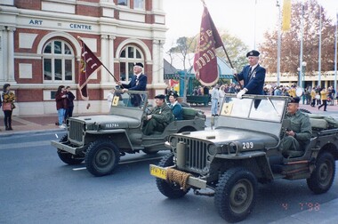
Staff - Sergeant Maurie Miles and WO 2 Lou Madjeric standing in Jeeps carrying guidons of 8th and 13th Light Horse, Reserve Forces Day Parade, Albury, 4 July 1998.reserve forces, parade, albury, guidon, military -
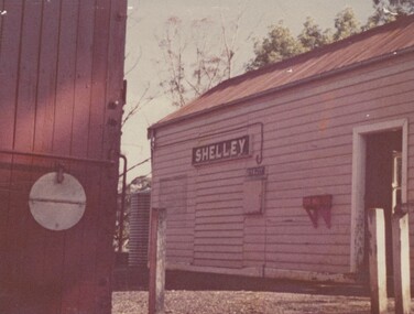 Wodonga & District Historical Society Inc
Photograph - Fred Rochow Railways Collection - Shelley Station
The Fred Rochow Railways Collection incorporates photos related to the operation of the Wodonga Railway Station including different types of trains and railways staff C. 1930 – 1990. It was donated to the Wodonga Historical Society by Fred Rochow, a railwayman who spent many years based in Wodonga. He joined the Victorian Railways on 17th June l947 and retired in 1988. For some time, he was a member of the Australian Federated Union of Locomotive Enginemen and served a term as a member of the Trades Hall Council. He had an extensive knowledge of the struggles that took place to achieve better conditions for railway workers. Fred worked for many years as a fireman and then worked his way up the ranks to driver, experiencing many changes from the days of steam locomotives through to diesel trains, locomotives and even the modern XPT train. He worked throughout Victoria at different stages of his career, with his final working years focused on the northeast of Victoria and the Albury to Melbourne line. After his retirement, Fred continued to share his love of steam miniature trains with the community. Shelley Railway Station - Shelley was once Victoria's highest railway station, located 781 metres above sea level. The Shelley Railway Station was opened in 1916 and closed in 1979. The railway was used early in its life to transport farmer’s livestock from the Upper Murray to Wodonga. From the 1950s the railway was used heavily to transport equipment and machinery from Wodonga to the Upper Murray to help build the Snowy Mountains Hydro Electric Scheme. The Snowy Hydro Scheme was completed in 1974 and after several years of low level use, the railway was closed. Some remnants of the Shelley Station passenger platform can still be seen today, along with some information boards. The Shelley Railway Station now forms part of the High Country Rail Trail.This collection has local and statewide significance as it captures images of trains, locomotives and personnel who operated the railway services in Wodonga and throughout Northeast Victoria. The railways played a critical role in opening up Victoria and connecting Australia for trade, business, social communication and transport.Shelley Railway Station. This image shows the tank where the hand brakes were lifted. They were applied again at the "up" side of Koetong for about another 10 miles then lifted near Bullioh.railways wodonga, fred rochow, shelley station, high country rail trail -
 Melbourne Tram Museum
Document - Memorandum, Ministry of Munitions, Sunday School Union Procession, 1943
Memorandum and note for tram scheduling for an exhibition of armaments and munitions through Melbourne on Friday 29 October 1943. 17 pages "Miles of Munitions 1943" List of Sub-Assembly Areas. 12 pagestrams, tramways, instructions, events, world war 2 -
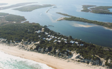 Lakes Entrance Historical Society
Photograph - Gippsland Lakes, 2005 c
Colour aerial photograph of Ocean Grange on the Gippsland Lakes ocean beach ninety mile beach in foreground Cresent Island channel through to Lake King Raymond Island in distance Paynsville Victoriaaerial photograph, settlement, gippsland lakes -
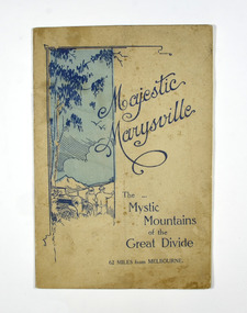 Marysville & District Historical Society
Booklet, Marysville Tourist Association, Magestic Marysville-The Mystic Mountains of the Great Divide, 1920's
An information guide of day trips to attractions in and around Marysville in Victoria. This booklet was produced by the Marysville Tourist Association.Paperback. Cover is beige with a drawing of two people standing next to a car looking at the view. The title is in dark blue across the front.non-fictionAn information guide of day trips to attractions in and around Marysville in Victoria. This booklet was produced by the Marysville Tourist Association.marysville, victoria, marysville tourise association, steavenson falls, keppel falls, cameron cascades, cumberland, mt cathedral, eildon, snob's creek falls, wolfram mine, mt strickland, keppel's lookout, mt kitchener, mt edgar, mt gordon, nichol's lookout, michael dene, beauty spot, gilbert's gully, taggerty river, wood's point -
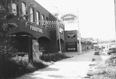 Ringwood and District Historical Society
Photograph, Maroondah Highway West, Ringwood- 1978. 15 mile peg at Guest's Furniture Store
Black and white photographPhotograph shows Guest's Furniture Forum store, and also the original 15 mile cement marker. -
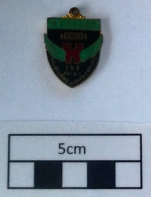 Geelong Cycling Club
Medallion, 1951
Awarded to participant L Stephenson of GWCC in 1951 on completion of the Melbourne to Warrnambool Road Race.L Stephenson is recorded from the late 1920s to 1951 and beyond as a successful racing cyclist with the GACC and GWCC. Awards of such medallions reflects the recognition given to the competitors of the Melbourne-Warrnambool road race over 163 Miles.Small enamelled medallion. It has a black background with green wings coming from a red centre figure. There are inscriptions on the black background and on a green header at the top of the badge. There are also inscriptions on the reverse side of the badge."Healing 1951 Melbourne-Warrnambool 163 Miles" "Jubilee Year 10/KC Luke Melbourne"geelong west cycling club; l stephenson; melbourne warrnambool road race; medallion; 1951; -
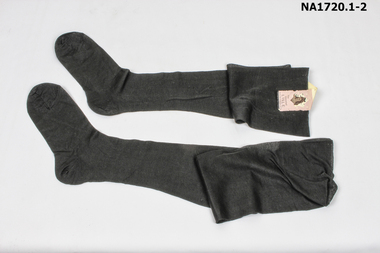 Whitehorse Historical Society Inc.
Clothing - Stockings
Pair of black lisle stockings with sticker joining the two together. (unused)The Faithful Sheer That gives Miles of Wear Fine Mercerised Lisle Nylon Reinforced Heel and Toe.costume, female footwear -
 Wodonga & District Historical Society Inc
Album - Hume Reservoir Australia Album - Plans and Progress Photos - River Murray Water Scheme, Department of Public Works, N.S.W, 1927
This set of photos is from a leather bound album bearing the inscription "HUME RESERVOIR AUSTRALIA" plus 'The Rt. Hon. L. C. M. S. Amery, P. C., M .P.' all inscribed in gold. It was presented to The Rt. Hon. L. C. M. S. Amery, P. C., M. P, Secretary of State for Dominion Affairs on the occasion of his visit to the Hume Reservoir on 2nd November 1927. This album is of local and national significance as it documents the planning and development of the Hume Reservoir up to 1927. It was the largest water reservoir in the British Empire. The album records the pioneering engineering work that went into its construction.1. Locality Plan and Plan of Dam. The dam is about ten miles by road upstream from Albury and about three-quarters of a mile below the confluence of the Mitta Mitta River and the Murray River. Its main features consist of a concrete portion across the bed of the river with earth embankment at both ends. The foundations throughout are on hard granite, found at an average depth of about 40 feet below the surface, the centre line being located to take advantage of the most favourable rock levels.Heading on page "WORKS UNDER RIVER MURRAY WATERS AGREEMENT/HUME RESERVOIR" Beneath top diagram "FIG. 1. ELEVATION" Beneath second diagram "FIG. 2. PLAN" On map "LOCALITY PLAN"hume reservoir australia, river murray waters scheme, hume weir diagrams, hume weir location