Showing 22477 items matching "parks"
-
 Whitehorse Historical Society Inc.
Document - Parks and Reserves Reports, July 2003
A list of Whitehorse Parks & Reserves dated July 2003, 2nd Edition. The Reports on them are held in the Local History Collections if the Nunawading Library,Parks and Reserves in Whitehorse July 2003.Blue cover page dated July 2003, 2nd Edition listing the Parks and Reserves in Whitehorse.parks and reserves, nunawading library -
 Rutherglen Historical Society
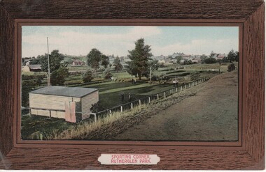
Image, Sporting Corner, Rutherglen Park, 1910 to 1912
Rutherglen Park is located in Murray Street. The grounds shown are now the bowling club. Photo taken from the top of the weir of Lake King.Coloured photograph on a post card, with brown border, showing a view of a one end of the Rutherglen Parksports grounds, rutherglen bowling club, rutherglen park, murray street -
 Kew Historical Society Inc
Photograph - 'Raheen', Studley Park Road (Kew), c.1965
"The first section of Raheen was commenced in 1870 with an extension added in 1884. It was designed by William Salway and built for Edward Latham of the Carlton Brewery. Sir Henry Wrixon, prominent Melbourne barrister and solicitor, later owned and resided at the property. In 1917 Raheen was purchased by the Catholic Church and became the official residence of Archbishop Mannix, as well as four other Catholic archbishops of Melbourne. In 1981 the Church sold the property and it again reverted to a private residence." (Victorian Heritage Database, 2023)This work forms part of the collection assembled by the historian Dorothy Rogers (1905-1973), donated to the Kew Historical Society by her son in 2015. The manuscripts, photographs, maps, and documents were sourced by her from both family and local collections or produced as references for her print publications. Many were directly used by Rogers in writing ‘Lovely Old Homes of Kew’ (1961) and 'A History of Kew' (1973), or the numerous articles on local history that she produced for suburban newspapers. Most of the photographs in the collection include detailed annotations in her hand. The Rogers Collection provides a comprehensive insight into the working habits of a historian from the 1960s to the 1970s. Original, monochrome print copy of a photograph of Raheen in Studley Park Road (Kew). The unrendered red brick house with tower has a toe story section at right with a double colonnade and a single story section at left. The photographs predates the restoration of the gardens and house by te. Pratt family. Annotation verso: "Raheen. R. C. Archbishops Palace, Studley Park Road, Kew".reheen, mansions -- kew (vic.), studley park road -
 Friends of Ballarat Botanical Gardens History Group
Work on paper - Victoria Park Precinct, City of Ballarat, Notes on the Parkland in the Nineteenth Century, Unknown
This page gives information about Victoria Park essentially from 1884-1894.Some idea is given here of Victoria Park back in history and plans for the planting of trees.1 page headed Victoria Park with a rough sketch of the Parkland area. There is an unfinished sentence at the bottom of the page and no page to follow.Nonejohn garner, doctor john garner, weston bates, george longley, curator, ballarat botanical gardens, night soil, ballarat council parks and gardens committee, gum trees, pines, victoria park, history friends of ballarat botanical gardens, john garner collection, gardens, ballarat -
 Kew Historical Society Inc
Photograph - Civic event in Stradbroke Park, 1976
Stradbroke Park. Extent: Kilby Road to Harp Road at Burke Road. Historical Documentation: 1851 - Portion 91 purchased by Edward Glynn; 1888 - The Harp of Erin Estate (which included Section 91) offered for sale; 1896 - The area now known as Stradbroke Park was bisected by a creek that flowed from the Yarra via Hay's Paddock (q.v.) and extended through to Burke Road; 1943 - W.D. Birrell, Town Clerk of Kew, proposed that the creek be filled and a reserve created; 1954 - Entire area designated as 'open space' and named 'Stradbroke Park'. The line of the creek that ran through the Park created a further reserve on the north side of High Street, now known as 'Harrison Reserve'. Existing Condition: The park is largely of mown grass that has mature trees set into it It is possible that a number of these are remnant of the original vegetation, while there are also a number of exotic trees introduced, particularly at the northern end of the park. The southern end is dominated by playing fields. (Source: Sanderson, P 1988. Kew Conservation Study)Colour photographic positive (with colour degradation) of sporting teams at a civic event in Stradbroke Park in Kew East in May 1976. The event was officiated by the Mayor of Kew, Cr Alan Hutchinson. Sporting teams in uniform included: footballers, athletes, cricketers, hockey players. Stradbroke Park is situated on the western boundary of Kew at Burke and Harp Roads.stradbroke park, cr alan hutchinson, team sports -- kew (vic.) -
 Stawell Historical Society Inc
Photograph, Mr George Jennings -- Studio Portrait
Portrait of George Jennings "Mayo Park" Lubeck. George Jennings was elected to Old Roads Board in 1863. Except for the years 1882 - 84. He served on the Council until 1891 - 1874 Shire President. From County Galway in Ireland. Jennings arrived in Pleasant Creek in 1858. For many years he owned "The Western Turf Hotel at Quartz Reefs. Selected land on the Ashens Run - settled there in 1870.Black and white photograph of a male in a oval setting with decoration in corners making a rectangle. Photograph in brown folder. The male is dressed in a suit, tie at neck of shirt, short hair and with a beard. Also an enlargement of studio photograph.George Jennings Mayo Park Lubeck written in biro.lubeck stawell shire president -
 Federation University Historical Collection
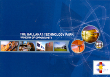
Booklet, The Ballarat Technology Park: Window of Opportunity, c2001
The Ballarat Technology Park is located on a 29 hectare site on the Mt Helen campus of Federation University Australia, and was officially launched in February 1995. The first tenant was IBM Global Services which employed 200 staff. The Greenhill Enterprise Centre is an IT incubator which, by the end of 2000, housed 20 businesses. 8 page colour booklet outlining the Ballarat Technology Park.ballarat technology park, greenhill enterprise centre, ibm global services, kerry cox, robert hook, southern region data centre, oztrak, ross haby -
 Kew Historical Society Inc
Photograph, J F C Farquhar, A View in Studley Park Road, 1891
At the beginning of the 1890s, the Kew businessman and Town Councillor, Henry Kellett, commissioned J.F.C. Farquhar to photograph scenes of Kew. These scenes included panoramas as well as pastoral scenes. The resulting set of twelve photographs was assembled in an album, Kew Where We Live, from which customers could select images for purchase.The preamble to the album describes that the photographs used the ‘argentic bromide’ process, now more commonly known as the gelatine silver process. This form of dry plate photography allowed for the negatives to be kept for weeks before processing, hence its value in landscape photography. The resulting images were considered to be finely grained and everlasting. Evidence of the success of Henry Kellett’s venture can be seen today, in that some of the photographs are held in national collections.It is believed that the Kew Historical Society’s copy of the Kellett album is unique and that the photographs in the book were the first copies taken from the original plates. It is the first and most important series of images produced about Kew. The individual images have proved essential in identifying buildings and places of heritage value in the district.This is the earliest known photograph of the exterior of Byram (later Tara Hall). It shows the original red brick fence, its asymmetrical gate and gateposts, with a large terra cotta gargoyle surmounting the higher of the two. The architect, Edward Kilburn designed Byram in the Arts & Crafts style for the industrialist George Ramsden. Construction began in 1888 and was reputed to have lasted three years. The mansion had frontages to Studley Park Road and Stevenson Street, including gardens laid out with great taste, including pleasure grounds, tennis lawn, fruit and flower garden, and paddock. The size of many of the trees in the garden indicate that many survived from the garden of Clifton Villa, the previous single-storeyed house built on the site by the Stevenson brothers. Byram had views to Melbourne and Port Phillip Bay. The house was demolished in 1960, despite opposition from the National Trust (Victoria), and its gardens subdivided into residential allotments.A View in Studley Park Roadkew illustrated, kew where we live, photographic books, henry kellett, byram, tara hall, goathlands -
 Clunes Museum
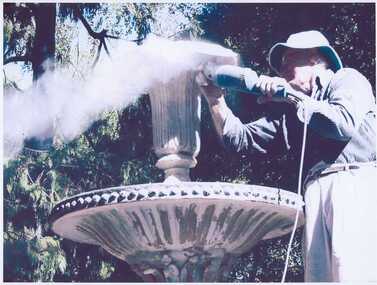
Photograph
QUEENS PARK RESTORATION CEREMONY 13TH JULY 2008EIGHT COLOURED PHOTOGRAPHS, TOGETHER WITH A LAMINATED REPORT RECOGNISING THE VOLUNTARY RESTORATION WORK OF THE QUEENS PARK FOUNTAIN BY DAVID COLEMAN AND LESLIE CAREY.local history, photography, photographs, queens park -
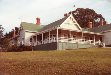
 Whitehorse Historical Society Inc.
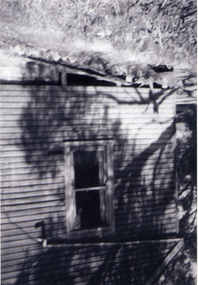
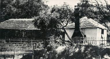
Photograph, Antonio Park - The Shack - East side, C1960
The photo is part of a set provided by Robin Harris of his early life (1953-1962) in 'The Shack' at Antonio Park. See ND5241 for his story 'When Antonio Park was home'.)Black & white photograph of the Shack in Antonio Park (1953-1962) showing the eastern side which faced Deep Creek Road. See ND5241 for history.antonio park mitcham, the shack, whitehorse road, mitcham, no.627, harris. robin, bushfire - 1962 -
 Phillip Island and District Historical Society Inc.
Photograph
One of a collection of over 400 photographs in an album commenced in 1960 and presented to the Phillip Island & Westernport Historical Society by the Shire of Phillip Island. This is the current Cowes Foreshore Tourist Park. 2020Photograph of the old TeaTree Tea House in the public Camping Park, Church Street, Cowes. phillip island, local history, photography, photographs, the old ti-tree tea house, black & white photograph, tea house, cowes, public camping park, john jenner, bryant west, camping -
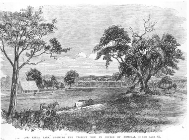 St Kilda Historical Society
Photograph - Photograph of artwork, St Kilda Park, showing the viaduct now in course of removal, 25/06/1867
St Kilda Park, now Albert Park Reserve, showing cows, eucalyptus trees, oval and a railway viaduct in background. The viaduct was part of the Windsor to St Kilda loop line which operated between 1857 and 1867. The loop line ran from the St Kilda railway station on a combination of wooden viaducts and earth embankments fifteen feet high, crossing over St Kilda and Punt Roads by way of bridges and then gradually decreasing to a level crossing at Union Street and then on to Windsor station. Black and white photograph of a lithograph published in a book (unidentified)ST KILDA PARK, SHOWING THE VIADUCT NOW IN COURSE OF REMOVAL - SEE PAGE 85st kilda railway station, albert park, windsor to st kilda rail loop -
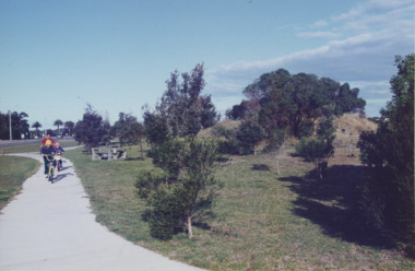 Lakes Entrance Historical Society
Photograph - Esplanade Lakes Entrance Victoria, Lakes Entrance Tidy Town, 1995 c
... Parks ...Colour photograph showing two children and an adult riding bicycles on pathway between south end of North Arm bridge and Bullock Island road. Middle distance left turn into Marine Parade foreground now site of skate park. In distance palm trees at entry to Esplanade Lakes Entrance Victoriarecreation, topography, roads and streets, parks -
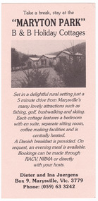 Marysville & District Historical Society
Flyer (item) - Information flyer, "MARYTON PARK" B & B Holiday Cottages, Unknown
An information flyer regarding Maryton Park B & B Holiday Cottages and the Danish Coffee Garden near Marysville.An information flyer regarding Maryton Park B & B Holiday Cottages and the Danish Coffee Garden near Marysville.marysville, victoria, australia, maryton park, danish coffee garden, accommodation, information flyer -
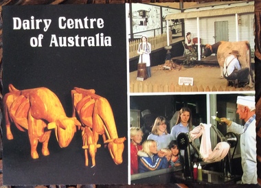 Phillip Island and District Historical Society Inc.
Postcard, Scancolor Australia et al, Dairy Centre and Rhylstone Park, Phillip Island, C. 1980s
Two coloured postcards. One of displays at the Dairy Centre, Newhaven. The second of Rhylston Park homestead, Cowes and it’s display of antiques and clocks.Dairy Museum, Phillip Island Road, Newhaven. Victoria 3925. Phone (059)567583 All Hours Rhylston Park Homestead Thompson Ave Cowes 3922 Phone (059)59522856. Rhylston Park(1886) features a display of over 380 antique clocks and watches. This unique collection is enhanced by the original homestead with beautiful lead light, ornate metal ceilings and marble fireplaces.the dairy centre, newhaven, homes, postcards -
 Surrey Hills Historical Society Collection
Photograph, Entrance to Wattle Park from Riversdale Road, 1912-1914
Information provided by Stan Smith: Riversdale Road looking east 1912-1914. Wattle Park, then a farm is on the right. The near row of trees across the picture, indicates the driveway in Wattle Park. Wattle Park was then Fenwick's farm - or - Fennies to the local boys. Note: Riversdale Road becomes not much more than a track after passing the farm entrance.A dirt road in the lower left corner of the photograph is bounded by a post and rail fence. Two cyclists are on the road. "Wattle Park" is written to the right side of the road.wattle park, 1912, farms, 1914, fenwicks farm, fennies, fences, trees, roads and streets, riversdale road, pine trees, gum trees, cyclists -
 Lakes Entrance Historical Society
Photograph - Nyerimilang, Fish Marie, 1982
Also two other photographs of derelict farm buildings at Nyerimilang Park, Kalimna West, Victoria.Colour photograph of homestead taken at Nyerimilang Park soon after purchase by Victorian State Government. Kalimna West Victoriahouses, local history -
 St Kilda Historical Society
Photograph, Esplanade St Kilda
view from Luna Park tower black and white photograph, unmounted, good conditionMelbourne Suburbs St Kilda View of Esplanade St Kilda from Luna Park Tower, stamped National Library of Australia -
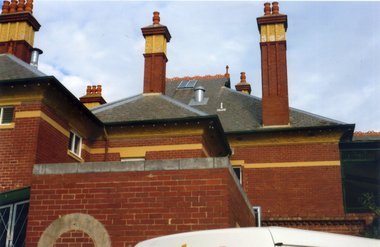 Whitehorse Historical Society Inc.
Photograph, Bundoora Park Homestead
In 1900, Mr J. V. Smith, the owner of Bundoora Park, organised a public competition for a design, in the Queen Ann style, for a mansion to be situated on the property. Australian Tesselated Tile Co. of Mitcham supplied many of the tiles and decorations for the building.Coloured photograph showing the detail on the roof and chimneys at Bundoora Park Homestead, Bundoorabundoora park homestead, australian tesselated tile co. pty ltd, tiles -
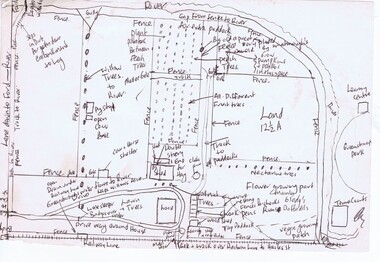 Greensborough Historical Society
Map, Gary Partington, Alwyn at Whatmough Park, 1960s
The property "Alwyn" was owned by the Partington family and was compulsorily acquired by the Shire of Diamond Valley to become Whatmough Park. This plan was drawn from memory by Gary Partington and illustrates land use when his father, Alan Partington, owned the property.This plan illustrates the rural nature of land around Greensborough prior to the 1960s.Drawing of land use in 1960s at "Alwyn", a property currently occupied by Whatmough Park alwyn, partington family, whatmough park -
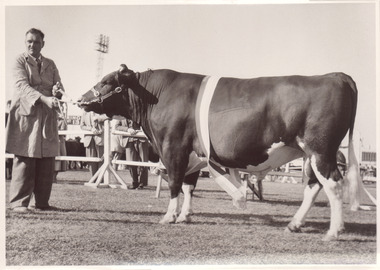 Melbourne Royal
Photograph, Frank Johnson, 1954
Black and white photograph of a Champion Friesian Bull Champion Friesian Bull. Glenhope Keystone Burkeyje. FJ Fox "Kingstone Park" Merricks NorthThis item is a part of a larger collection of 4,500 Frank Johnson photographs and negatives donated to Melbourne Royal by Frank Johnson’s daughter, Francis Beatty Wallace in 2016. This collection spanning from the 1930s to the 1980s holds important social and historical significance in preserving and sharing Victoria’s agricultural history and community. The photographs capture the local, regional, and state’s shared relationships developed through agriculture and the importance of farming and husbandry to the population and development of Australia. A large proportion of these photographs depict events from the Royal Melbourne Show, including livestock competitions, exhibitions and awards ceremonies. Dating back to 1848 when the society first began, the Royal Melbourne Show has held a special place in the hearts and minds of Victorians, allowing for extensive showcasing and celebration of agricultural excellence, bridging the divide between metropolitan and rural Victoria.A black and white photograph, landscape, printed on gloss paper with a white borderChampion Friesian Bull. Glenhope Keystone Burkeyje. FJ Fox "Kingstone Park" Merricks Northroyal melbourne show, friesian, bull, agricultural shows, blue ribbon competitions, winners, glenhope, kingstone, fj fox, fox -
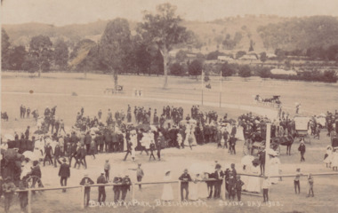 The Beechworth Burke Museum
Postcard, 1908
Printed in 1908, the postcard depicts a public gathering at Baarmutha Park, Beechworth on Boxing Day the same year. There are many men, women and children dressed in formal attire including suits and hats. A large number of women are holding parasols. Multiple horse-drawn carts are visible throughout the image.The record is historically significant due to its production in the very early twentieth century. This significance is enhanced by its contextual information, as the record provides insight into the social and leisure activities enjoyed by people at Baarmutha Park during this time.Sepia rectangular postcard printed on card.Obverse: BAARMUTHA PARK, BEECHWORTH. BOXING DAY, 1908. / Reverse: Parks & Gardens. / POST CARD. / KODAK / CORRESPONDENCE. / ADDRESS ONLY. / AUSTRAL / AUSTRAL / KODAK / (?) Craig / Stanley / 3747 / 9/ - Boxing Day / Sports Baarmutha / Park Beechworth / 84-148-1 / GARDENS / 97.2335 / 79.21.9 /entertainment album, baarmutha park, beechworth, 1900s, social, leisure, gathering, horses -
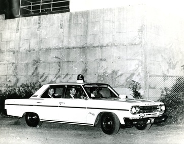 Victoria Police Museum
Photograph (police car)
A Wireless Patrol crew parked outside Pentridge prison at the time of the hanging of Ronald Ryan.A Rambler Classic, registration number JNK-705, parked outside Pentridge with Ken Bryant and Doug Hilton in the car. Circa 1967police vehicles; motor transport branch; motor transport section; wireless patrol; rambler classic car; bryant, ken; hilton, doug; pentridge prison -
Whitehorse Historical Society Inc.
Article, Famed senior dies, 114, 2002
Whitehorse's most famous senior citizen,Whitehorse's most famous senior citizen, Christina Cock died at the Victorian Deaf Society's Lake Park Nursing Home in Blackburn.Whitehorse's most famous senior citizen, cock, christina, obituaries -
Whitehorse Historical Society Inc.
Article, Taking his best shot, 2004
Article about John Collings and his work as an architectural photographer.Article about John Collings and his work as an architectural photographer. Includes his first commission for Merchant Builders at Winter Park in Vermont.Article about John Collings and his work as an architectural photographer.collings, john, merchant builders, yencken, david, ridge, john, gollings, sam, photography, winter park, vermont -
 Vision Australia
Photograph - Image, Braille and Talking Book Library garden
Adjacent to the Braille and Talking Book Library was a small garden area. In this image, the park bench to the far left sits behind the fence facing Commercial Road.Lawn area with medium sized tree in the centre and two parks benches some distance either sidebraille & talking book library, robert de graauw -
 Bendigo Historical Society Inc.
Document - LYDIA CHANCELLOR COLLECTION: BUSHRANGERS
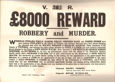
2 wanted posters, white with large black writing. 8000 pound REWARD. ROBBERY AND MURDER. Reward will be paid for information. The posters are announcing a reward for the apprehension of Edward Kelly, Daniel Kelly, Stephen Hart and Joseph Byrne. Signed Henry Parkes Colonial Secretary, N.S.W., Bryan O'Loghlen, Attorney General, VictoriaSigned Henry Parkes Colonial Secretary, N.S.W., Bryan O'Loghlen, Attorney General, Victoriahistory, australian, bushrangers, lydia chancellor, collection, australian history, history, bushrangers, victorian history, australia -
 Stawell Historical Society Inc
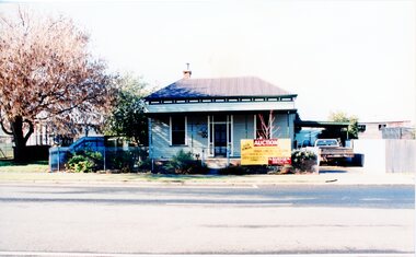
Photograph, House Removal. Victoria Street Rob Holloway, July 1996
7103 - House with auction removal sign. -1 The view across the road to central park -2 View from the side showing seedling house and Stawell Bowling club -3 Showing the house on the truck looking towards the cab of the truck. -4 Looking back towards the house on the truck -5 The house on the truck just before turning a corner6 colour photographs showing the parks and gardens superintendents house streetscape -
 Buninyong & District Historical Society
Photograph - Original B/W Photograph, De Soza park, Warrenheip St., Buninyong, with poppet head, rotunda and Chilean Wheel sculpture
De Soza park was developed as a public amenity from the early 1980s. The poppet head and Chilean wheel sculpture are representative of the gold mining origins of the town.The park, located centrally in Buninyong is of social and historic significance.Original B/W photograph of streetscape of De Soza park frontage to Warrenheip St., Buninyong, with poppet head, rotunda and Chilean Wheel sculpture, former post office in background. Large eucalypt tree present behind rotunda, large cypress tree to north of park.buninyong, de soza, park, rotunda, poppet head, sculpture, chilean wheel, post office, warrenheip st, streetscape -
 Stawell Historical Society Inc
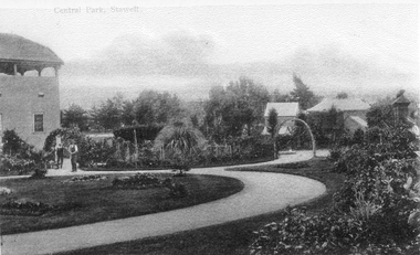
Photograph, Central Park Gardens
Central Park Gardens. Archway looking West, two workmen visible beside No1 Grandstand. Print of photograph of Central Park Gardens view looking west. Two workman under archway in the left of the photo with grandstand behind.stawell