Showing 16883 items matching "plenty-river"
-
 Eltham District Historical Society Inc
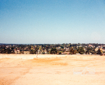
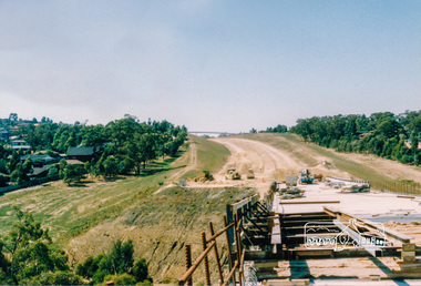
Photograph, Looking slightly east of south towards Greensborough Plaza from near the Plenty River; Greensborough Bypass construction, c.1986, 1986c
Colour photograph originally located in a magnetic style album titled 'Greensborough Bypass 1990s 5' suffering significant degradation. No information contained in album or on reverse of photos except where noted. Relocated to archival photosafe storage.greensborough bypass, road construction, greensborough -
 Eltham District Historical Society Inc
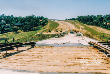
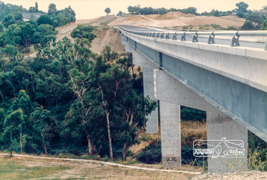
Photograph, Looking west across the new bridge construction across the Plenty River from the eastern side; Greensborough Bypass construction, c.1986, 1986c
Colour photograph originally located in a magnetic style album titled 'Greensborough Bypass 1990s 5' suffering significant degradation. No information contained in album or on reverse of photos except where noted. Relocated to archival photosafe storage.greensborough bypass, road construction, greensborough, bridge construction -
 Eltham District Historical Society Inc
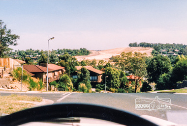
Photograph, Looking slightly east of south towards Greensborough Plaza from near the Plenty River; Greensborough Bypass construction, c.1986, 1986c
Colour photograph originally located in a magnetic style album titled 'Greensborough Bypass 1990s 5' suffering significant degradation. No information contained in album or on reverse of photos except where noted. Relocated to archival photosafe storage.greensborough bypass, road construction, greensborough, greensborough plaza -
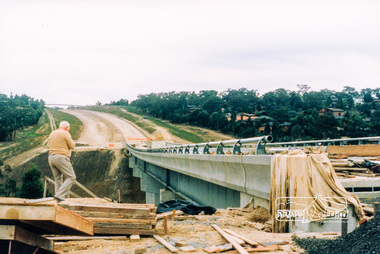
 Eltham District Historical Society Inc
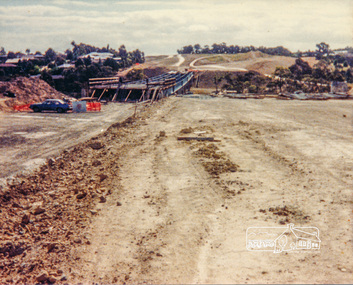
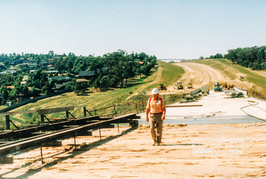
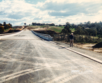
Photograph, Looking east across the new bridge construction across the Plenty River from the western side up to the new roundabout at Civic Drive; Greensborough Bypass construction, c.1986, 1986c
Colour photograph originally located in a magnetic style album titled 'Greensborough Bypass 1990s 5' suffering significant degradation. No information contained in album or on reverse of photos except where noted. Relocated to archival photosafe storage.greensborough bypass, road construction, greensborough, bridge construction -
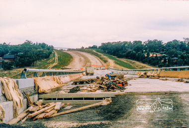
 Eltham District Historical Society Inc
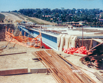
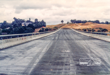
Photograph, Looking east across the new 5-span bridge construction across the Plenty River; Greensborough Bypass construction, c.1986, 1986c
Colour photograph originally located in a magnetic style album titled 'Greensborough Bypass 1990s 5' suffering significant degradation. No information contained in album or on reverse of photos except where noted. Relocated to archival photosafe storage.greensborough bypass, road construction, greensborough, bridge construction -
 Eltham District Historical Society Inc
Photograph, Looking slightly east of south towards Greensborough Plaza from near the Plenty River; Greensborough Bypass construction, c.1986, 1986c
Colour photograph originally located in a magnetic style album titled 'Greensborough Bypass 1990s 5' suffering significant degradation. No information contained in album or on reverse of photos except where noted. Relocated to archival photosafe storage.greensborough bypass, road construction, greensborough, greensborough plaza -
 Eltham District Historical Society Inc
Photograph, Looking east across the new 5-span bridge construction across the Plenty River; Greensborough Bypass construction, c.1986, 1986c
Colour photograph originally located in a magnetic style album titled 'Greensborough Bypass 1990s 5' suffering significant degradation. No information contained in album or on reverse of photos except where noted. Relocated to archival photosafe storage.greensborough bypass, road construction, greensborough, bridge construction -
 Eltham District Historical Society Inc
Photograph, Looking east across the new 5-span bridge construction across the Plenty River; Greensborough Bypass construction, c.1986, 1986c
Colour photograph originally located in a magnetic style album titled 'Greensborough Bypass 1990s 5' suffering significant degradation. No information contained in album or on reverse of photos except where noted. Relocated to archival photosafe storage.greensborough bypass, road construction, greensborough, bridge construction -
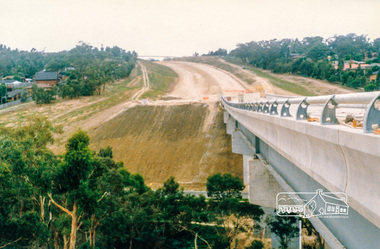
 Eltham District Historical Society Inc
Photograph, Looking northeast across the new 5-span bridge construction across the Plenty River; Greensborough Bypass construction, c.1986, 1986c
Colour photograph originally located in a magnetic style album titled 'Greensborough Bypass 1990s 5' suffering significant degradation. No information contained in album or on reverse of photos except where noted. Relocated to archival photosafe storage.greensborough bypass, road construction, greensborough, northern ring road -
 Eltham District Historical Society Inc
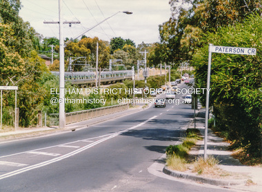
Photograph, Looking west along Plenty River Drive near intersection with Goonyah Court, Greensborough, c.1986, 1986c
Colour photograph originally located in a magnetic style album titled 'Greensborough Bypass 1990s 5' suffering significant degradation. No information contained in album or on reverse of photos except where noted. Relocated to archival photosafe storage.greensborough bypass, road construction, greensborough, plenty river drive, goonyah court -
 Eltham District Historical Society Inc
Photograph, Looking east across the new 5-span bridge construction across the Plenty River; Greensborough Bypass construction, c.1986, 1986c
Colour photograph originally located in a magnetic style album titled 'Greensborough Bypass 1990s 5' suffering significant degradation. No information contained in album or on reverse of photos except where noted. Relocated to archival photosafe storage.greensborough bypass, road construction, greensborough, bridge construction -
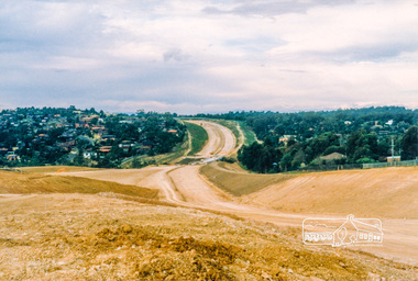
 Eltham District Historical Society Inc
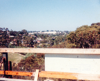
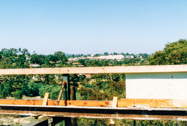
Photograph, Looking west across the new bridge construction across the Plenty River from the eastern side; Greensborough Bypass construction, c.1986, 1986c
Shows the service access road on the hill side which would later be cut away to provide the connection to the Northern Ring Road which was opened in April 1994.Colour photograph originally located in a magnetic style album titled 'Greensborough Bypass 1990s 5' suffering significant degradation. No information contained in album or on reverse of photos except where noted. Relocated to archival photosafe storage.greensborough bypass, road construction, greensborough, northern ring road -
 Eltham District Historical Society Inc
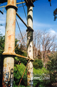
Photograph, The Maroondah Aqueduct System Old Pipe Bridge, Plenty River Walk, Greensborough, c.1989, 1989c
Colour photograph originally located in a magnetic style album titled 'Greensborough Bypass 1990s 5' suffering significant degradation. No information contained in album or on reverse of photos except where noted. Relocated to archival photosafe storage.greensborough, plenty river walk, maroondah aqueduct -
 Eltham District Historical Society Inc
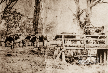
Photograph, Steam engine being hauled by bullock team, possibly over the Plenty River Bridge, Main Street, Greensborough, c.1870, 1870c
Photograph copy originally located in a magnetic style album titled 'Greensborough Bypass 1990s 5' suffering significant degradation. No information contained in album or on reverse of photos except where noted. Relocated to archival photosafe storage.greensborough, main street, plenty river bridge, steam engine, bullock team -
 Eltham District Historical Society Inc
Photograph, Doug Orford, Bridge across Plenty River, Para Road, Briar Hill, 1991, 1991
From a collection of 35 photos taken by Doug Orford at 35 specific locations along the exact boundary of the then Shire of Eltham.Colour photographbridges, plenty river, para road, briar hill -
 Eltham District Historical Society Inc
Photograph, Para Road Bridge over the Plenty River at Briar Hill, Jan 1986, January 1986
Boundary of Eltham and Diamond Valley Shires looking northRoll of 35mm colour negative film, 3 stripsKodak CL 200 5093bridge, para road, briar hill -
 Eltham District Historical Society Inc
Photograph, Para Road, Montmorency, industrial area looking south from Plenty River Bridge on boundary of Shire of Eltham
Colour photograph02076, montmorency (france) photo album, montmorency, para road, plenty river, industry -
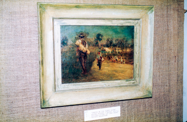 Eltham District Historical Society Inc
Photograph, Peter Bassett-Smith, Sketch on the Plenty River, Walter Withers (c.1895), 1988
Bicentennial/Heritage Week Display, "The Eltham Tradition", Eltham Shire Office, 17-22 April 1988 Colour photographactivities, eltham shire office, heritage display, heritage week, walter withers -
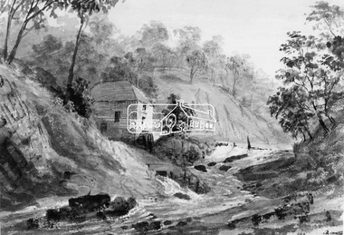 Eltham District Historical Society Inc
Photograph, Old Mill on Plenty River
This photo forms part of a collection of photographs gathered by the Shire of Eltham for their centenary project book,"Pioneers and Painters: 100 years of the Shire of Eltham" by Alan Marshall (1971). The collection of over 500 images is held in partnership between Eltham District Historical Society and Yarra Plenty Regional Library (Eltham Library) and is now formally known as the 'The Shire of Eltham Pioneers Photograph Collection.' It is significant in being the first community sourced collection representing the places and people of the Shire's first one hundred years.Digital imageshire of eltham pioneers photograph collection, old mill, other areas, plenty river, bundoora, water mill -
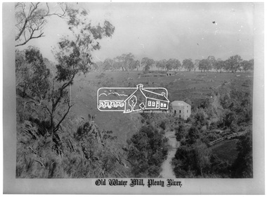
 Eltham District Historical Society Inc
Photograph, George Alexander Gilbert 1815-1877, Anderson's Mill on the River Plenty, 1849
This photo forms part of a collection of photographs gathered by the Shire of Eltham for their centenary project book,"Pioneers and Painters: 100 years of the Shire of Eltham" by Alan Marshall (1971). The collection of over 500 images is held in partnership between Eltham District Historical Society and Yarra Plenty Regional Library (Eltham Library) and is now formally known as the 'The Shire of Eltham Pioneers Photograph Collection.' It is significant in being the first community sourced collection representing the places and people of the Shire's first one hundred years.Digital imageshire of eltham pioneers photograph collection, other areas, plenty river, anderson's mill -
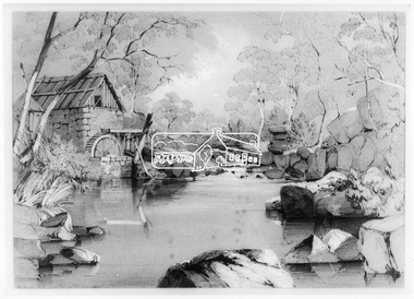
 Eltham District Historical Society Inc
Photograph, Fred Kruger, Old Water Mill, Plenty River, 1880
This photo forms part of a collection of photographs gathered by the Shire of Eltham for their centenary project book,"Pioneers and Painters: 100 years of the Shire of Eltham" by Alan Marshall (1971). The collection of over 500 images is held in partnership between Eltham District Historical Society and Yarra Plenty Regional Library (Eltham Library) and is now formally known as the 'The Shire of Eltham Pioneers Photograph Collection.' It is significant in being the first community sourced collection representing the places and people of the Shire's first one hundred years.Digital image and 35 mm B&W negativesepp, shire of eltham pioneers photograph collection, other areas, plenty river, water mill, bundoora -
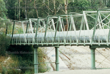 Nillumbik Historical Society Incorporated
Photograph - Colour photograph, Aqueduct Pipeline crossing the Plenty River
Colour Photograph -
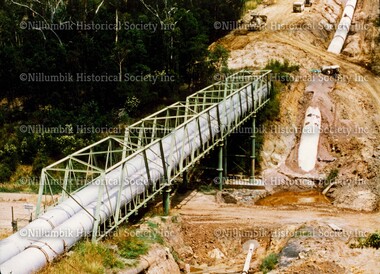
 Nillumbik Historical Society Incorporated
Photograph - Colour photograph, Steel Pipeline over Plenty River
Colour photographdiamond creek state school, diamond creek, nillumbik school -
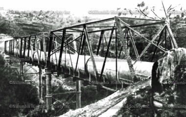 Nillumbik Historical Society Incorporated
Photograph - Black & white photograph, Pipeline crossing Plenty River
Black & white photographdiamond creek state school, diamond creek, nillumbik school -
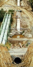
 Nillumbik Historical Society Incorporated
Photograph - Colour photograph, Aqueduct Excavations and Pipeline over Plenty River
Colour photographdiamond creek state school, diamond creek, nillumbik school -
 Nillumbik Historical Society Incorporated
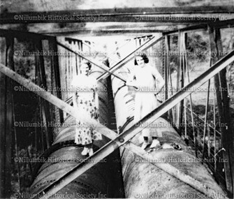
Photograph - Black & white photograph, Two ladies standing on pipeline over Plenty River
Black & white photographdiamond creek state school, diamond creek, nillumbik school