Showing 11154 items
matching re-survey
-
 Port Melbourne Historical & Preservation Society
Letter - Department of Lands and Survey re proclaimation for site of Sandridge municipal common, Department of Lands and Survey, 10 Oct 1863
Handwritten letter on blue foolscap laid paper, from Dept of Lands and Survey 10.10.1863, directing attention to proclamation in Government Gazette re site for Sandridge municipal common. Paper, watermarked TH Saunders 1862local government - borough of sandridge, port melbourne town hall -
University of Melbourne, Burnley Campus Archives
Document, Re-organization of field staff, 1950
Memorandum on re-organization of field staffmemorandum, staff -
 Queenscliffe Maritime Museum
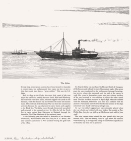
Newspaper - Newspaper clippings about SS EDINA, Cuttings & photos re SS ADINA, c1977
Lighthouse keepersLighthouse keeper's life & timesNewspaper clippings re SS ADINANilhistory -
 Bendigo Military Museum
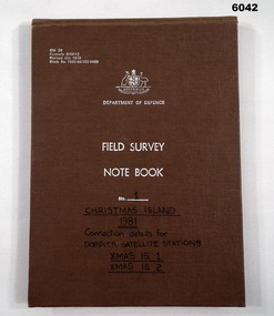
Journal - Field Survey Notebook No1 Christmas Island 1981, SSGT JD Mobbs and CPL NF Kelly, Department of Defence, Field survey Notebook No1 Christmas Island 1981, 09.02.1981
Notebook compiled by J.D. Mobbs, SSGT and N.F. Kelly, CPLCloth covered Cardboard, 100 Pages, Field Survey Notebook"Connection Details for Doppler Satellite Stations." "Xmas Is 1", "Xmas Is 2"royal australian survey corps, rasvy, fortuna, army survey regiment, army svy regt, asr -
 Ringwood and District Historical Society
Map, Commonwealth Department of Defence, Military Survey map of Ringwood, 1916, Jun-16
Map prepared by Commonwealth Section Imperial General Staff given to Ringwood Historical SocietyMilitary Survey map of Ringwood +Additional Keywords: Hutchins,LL.Hutchins, 16 King's Rd. Marysville 3779. Received by postpak -
Whitehorse Historical Society Inc.
Document, Report to the people of Nunawading on the outcome on the survey of amalgamations, 1994
Nunawading Gazette insert reporting results of council amalgamation survey.Nunawading Gazette insert reporting results of council amalgamation survey.Nunawading Gazette insert reporting results of council amalgamation survey.local government, amalgamations, city of box hill, city of nunawading, city of doncaster and templestowe, city of waverley, city of ringwood -
Whitehorse Historical Society Inc.
Book, Blackburn Lake Pollution Survey, 1/04/1973 12:00:00 AM
Blackburn Lake pollution survey [undertaken for the Nunawading City Council]Blackburn Lake pollution survey [undertaken for the Nunawading City Council]Blackburn Lake pollution survey [undertaken for the Nunawading City Council]city of nunawading, blackburn lake sanctuary, pollution -
 Ballarat Heritage Services
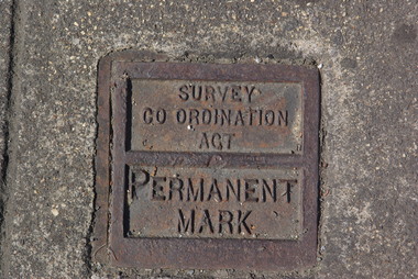
Photograph - Colour, Clare Gervasoni, Permanent Survey Mark on the Corner of Sturt Street and Doveton Street, Ballarat, 2011, 29/12/2011
Colour photograph of a metal survey mark in Sturt Street, Ballarat. sturt street ballarat, survey mark -
Linton Mechanics Institute and Free Library Collection
Book - Novel, Craik, Dinah Maria Mulock, A noble life. 'By the author of 'John Halifax, Gentleman', 'Christian's Mistake', etc. etc.' (Known to be Dinah Maria Mulock Craik), [n.d.] [First published 1866, date of this edition c.1895]
314 p. Brown and red cover - leather overlaid by cloth. Title 'A Noble Life' and 'Smythesdale Mech. Institute' embossed in gold on spine.fictionfiction, dinah maria mulock craik -
 Otway Districts Historical Society
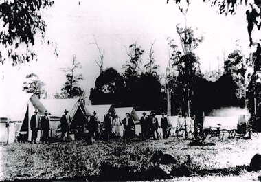
Photograph, Knox Collection, Survey camp for Colac-Beech Forest railway, 1901, 1901
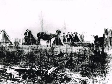
Plans for a rail connection between Colac and Beech Forest had been drawn up in 1884 and 1889 but proofed inconclusive because of the enormous cost involved in building a railway in such difficult terrain. Because of the financial depression in the early 1890s such expenditure went of hold. Towards the end of the decade planners recognised that a narrow gauge could be a viable alternative and it was taken up by the community, Parliamentary representatives and the government, although Victorian Railways administration was against the idea. This was overridden. The 1898 Parliament approved a 2 foot 6 inch gauge from Colac to Beech Forest although strict financial limits were set. The route was to be the most direct and the infrastructure the most basic. Construction began in 1900 entailing very steep grades and myriad curves until it finished in 1902. Surveyors and their assistants came before and during the track laying for the whole distance.B/W. Survey camp for the Colac-Beech Forest railway in 1901, showing nine tents, ten men including a cook, survey instruments, and three bicycles. Note the cooking fire on the right.colac: beech forest; railways; survey; -
 National Vietnam Veterans Museum (NVVM)
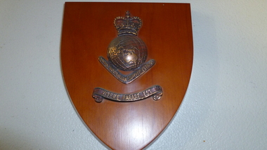
Plaque, Royal Australian Survey Corps
Wooden plaque with bronze decal of a crown atop a globe of the world on a boomerangVidere Parare Est Royal Australian Survey Corpsplaque, royal australian survey corps -
Federation University Historical Collection
Photograph, Re-opening of the Ballarat School of Mines Museum 1999, 1999
Re-opening of the Ballarat School of Mines Museumballarat school of mines museum, museum, david caro, david james, carole seymour, val d'angri, graham beanland, jack barker, e.j. barker, michael ronaldson -
University of Melbourne, Burnley Campus Archives
Document, Re CRTS Trainees P. Hopkins & J. Campbell, 1947
Memo to Mr. Kneen re disciplinary actiont.h. kneen, crts, students, p. hopkins, j. campbell, disciplinary action -
 Bendigo Military Museum
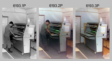
Photograph - Print Technician operating a Plan Printer at the Army Survey Regiment, Fortuna Villa Bendigo, 1990
These three photographs were most likely taken in the 1990s in Lithographic Squadron at the Army Survey Regiment, Fortuna, Bendigo. In photos .1P to .2P the Print Technician is using the Admal Plan Printer to process the exposed contone (black & white) copy of a map sheet. This is a set of three photographs of a print technician operating a Plan Printer at the Army Survey Regiment, Bendigo c1990s. The photographs were on 35mm negative film and were scanned at 96 dpi. They are part of the Army Survey Regiment’s Collection. .1) - Photo, black & white, c1990s, CPL Roy Hicks operating Admal Plan Printer. .2) - Photo, colour, c1990s, CPL Roy Hicks operating Admal Plan Printer. .3) - Photo, colour, c1990s, Admal Plan Printer. .1P to .3P – there are no annotations.royal australian survey corps, rasvy, army survey regiment, army svy regt, fortuna, asr, litho -
Federation University Historical Collection
Book, Ballarat Performing Arts: A Facilities Usage Survey, 1986
A usage survey for Ballarat performing arts published by the Victorian Ministry for the Arts.victorian ministry for the arts, performing arts, courthouse theatre, her majestys, theatres, memorial theatre, founder hall, mt clear technical school, civic hall, victorian theatre sovereign hill -
Whitehorse Historical Society Inc.
Document, Wandinong Floristic survey, 1993
A survey and management prescriptions for the enhancement of indigenous vegetation and the control of weed species.A survey and management prescriptions for the enhancement of indigenous vegetation and the control of weed species.A survey and management prescriptions for the enhancement of indigenous vegetation and the control of weed species.wandinong sanctuary, native plants, weeds -
 Otway Districts Historical Society
Photograph, Railway survey camp, c.1901, c.1901
Six surveyors and a horse posing outside five tents somewhere on the Beech Forest line in approximately 1901.Photograph, B/W. Railway survey camp, Beech Forest line.survey camp; beech forest; railways; -
 Melbourne Tram Museum
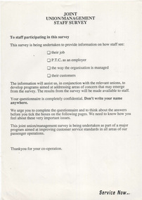
Document - Notice, The Met, Public Transport Corporation, "Joint Union/Management Staff Survey", "Summary of Surveys undertaken in the PTC", early 1990's
.1 - Notice - A4 sheet - titled "Joint Union/Management Staff Survey", not dated, detailing the scope of a survey to be undertaken by the PTC asking information about the feeling for important issues. Has the term "Service Now" in the bottom right hand corner. .2 - A4 Sheet titled "Summary of Surveys undertaken in the PTC", detailing 5 surveys between 1985 and 1990, giving purpose, purpose and benefits - included staff attitudes, equal employment opportunity, consultation, clerical and smoking.trams, tramways, surveys, smoking, ptc, staff, unions, employment -
 Federation University Historical Collection
Plan - Contour tracings, Ballarat University College residence carparks and detail survey of Mt Helen campus, 1991/1992
3 ink on tracing paper survey maps .1) Detail survey Mt Helen campus 1992 .2) Top residence car park 1991 .3) BUC residences' car park 1991ink on tracing paper, b.u.c surveys, transpotr, ballarat college of advanced education, mount helen campus, carpark, student residences -
 St Kilda Historical Society
Photograph - Photo map, Department of Crown Lands and Survey (1857-1983), 22/01/1970
One of a series of photo-maps produced for the Department of Crown Lands and Survey (1857-1983). For correlation with a current map, and access to other historical photo maps of Victoria, see the Historic Photo-Maps Index published by the Department of Environment, Land, Water and Planning at https://services.land.vic.gov.au/DELWPmaps/historical-photomaps/Black and white aerial photographVic 2358 Department of Crown Lands and Survey Victoria,.© Melbourne 1970 Project Run 41E 22.1.70 5,100 ASL 62caulfield, caulfield north, st kilda east, armadale, 1970 -
 St Kilda Historical Society
Photograph - Photo map, Department of Crown Lands and Survey (1857-1983), 22/01/1970
One of a series of photo-maps produced for the Department of Crown Lands and Survey (1857-1983). For correlation with a current map, and access to other historical photo maps of Victoria, see the Historic Photo-Maps Index published by the Department of Environment, Land, Water and Planning at https://services.land.vic.gov.au/DELWPmaps/historical-photomaps/Black and white aerial photographVic 2358 Department of Crown Lands and Survey Victoria,.© Melbourne 1970 Project Run 42E 22.1.70 5,100 ASL 77st kilda, st kilda east, st kilda marina, elwood, elwood canal, elsternwick park, point ormond, balaclava, mc moran reserve, ripponlea, st kilda botanical gardens, peanut farm, 1970 -
 St Kilda Historical Society
Photograph - Photo map, Department of Crown Lands and Survey, 22/01/1970
One of a series of photo-maps produced for the Department of Crown Lands and Survey (1857-1983). For correlation with a current map, and access to other historical photo maps of Victoria, see the Historic Photo-Maps Index published by the Department of Environment, Land, Water and Planning at https://services.land.vic.gov.au/DELWPmaps/historical-photomaps/Black and white aerial photographVic 2358 Department of Crown Lands and Survey Victoria,.© Melbourne 1970 Project Run 43E 22.1.70 5,100 ASL 208elwood, elwood beach, point ormond, elwood park, elwood canal, mc moran reserve, 1970 -
 St Kilda Historical Society
Photograph - Photo map, Department of Crown Lands and Survey, 22/01/1970
One of a series of photo-maps produced for the Department of Crown Lands and Survey (1857-1983). For correlation with a current map, and access to other historical photo maps of Victoria, see the Historic Photo-Maps Index published by the Department of Environment, Land, Water and Planning at https://services.land.vic.gov.au/DELWPmaps/historical-photomaps/Black and white aerial photographVic 2358 Department of Crown Lands and Survey Victoria,.© Melbourne 1970 Project Run 42E 22.1.70 5,100 ASL 75st kilda, st kilda beach, st kilda marina, point ormond, st kilda pier, 1970 -
 St Kilda Historical Society
Photograph - Photo map, Department of Crown Lands and Survey, 22/01/1970
One of a series of photo-maps produced for the Department of Crown Lands and Survey (1857-1983). For correlation with a current map, and access to other historical photo maps of Victoria, see the Historic Photo-Maps Index published by the Department of Environment, Land, Water and Planning at https://services.land.vic.gov.au/DELWPmaps/historical-photomaps/Black and white aerial photographVic 2358 Department of Crown Lands and Survey Victoria,.© Melbourne 1970 Project Run 41E 22.1.70 5,100 ASL 64st kilda, st kilda cemetery, balaclava, st kilda east, windsor, caulfield north, alma park, 1970 -
 St Kilda Historical Society
Photograph - Photo map, Department of Crown Lands and Survey, 08/01/1970
One of a series of photo-maps produced for the Department of Crown Lands and Survey (1857-1983). For correlation with a current map, and access to other historical photo maps of Victoria, see the Historic Photo-Maps Index published by the Department of Environment, Land, Water and Planning at https://services.land.vic.gov.au/DELWPmaps/historical-photomaps/Black and white arial photographVic 2345 Department of Crown Lands and Survey Victoria,.© Melbourne 1970 Project Run 40 8.1.70 5,100 ASL 77albert park, fawkner park, south yarra, middle park, prahran, windsor, st kilda, st kilda west, 1970 -
 St Kilda Historical Society
Photograph - Photo map, 22/01/1970
One of a series of photo-maps produced for the Department of Crown Lands and Survey (1857-1983). For correlation with a current map, and access to other historical photo maps of Victoria, see the Historic Photo-Maps Index published by the Department of Environment, Land, Water and Planning at https://services.land.vic.gov.au/DELWPmaps/historical-photomaps/Black and white aerial photographVic 2358 Department of Crown Lands and Survey Victoria,.© Melbourne 1970 Project Run 43E 22.1.70 5,100 ASL 206elwood, elsternwick, elsternwick park, 1970 -
 Ringwood and District Historical Society
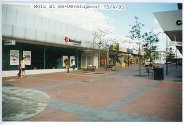
photograph, Eastlink Ringwood Bypass Construction-Melb St Re-Development 15/4/95
Colour photographWritten on back of photo: "Melbourne St Re-Development 15/4/95 -
 Stawell Historical Society Inc
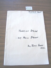
Book - Local History, John Hart, Inquiries Re Hoskins Store 1934 to 195 - 107 Main Street, 1990
Recollection's of People who worked in Hoskins Store before being taken over by G.J. ColesManila Folder with Black Text.Handwritten: Inquires Re Hoskins Store - 107 Main Street. By John Hartstawell business -
 Federation University Historical Collection
Map, Ballaarat Gold Field, 1861, 1861
A party of surveyors camped by Yuille's Swamp (later Lake Wendouree) and surveyed the countryside for a map to be produced by the Geological Survey of Victoria. In November 2004 the Central Highlands Regional Library presented a special edition of 200 copies of the 1861 map reproduced from a copy in their collection. Original 1861 map of Ballarat showing streets and leads. Blue dots indicate gold leads, and red lines indicate auriferous quartz reef and outcrops of quartz veins."Compiled & Drawn from the Survey of Mining Surveyors Davidson, Fitzpatrick and Cowan & the Plans in the Surveyor General's Office by J. Brahe, 21st October 1861. R. Brough Smyth, Secretary for Mines. The Honourable J.B. Humffray, M.L.A. Commr of Mines.”ballarat, map, ballarat east, lake wendouree, survey, mines, robert davidson, ballarat gold field 1861, yuille's swamp, wendouree swamp, little bendigo diggings, gold leads, old post office hill, specimen hill, bakery hill, black hill, dead horse creek, brown hill, pennyweight hill, clayton hill, soldiers hill, golden point, gum tree flat, white flat, poverty hill, chinese village, robert brough smyth, ballarat map 1861, ballaarat vineyard, dead horse gully, deadhorse creek, invermay, black hill flat, gaelic church, police reserve, magpie range, dalton's flat, caadian lead, rifle butts, powder magazine, bathing house, government camp, gold office, chinese, llanberrris, victoria theatre, charlie napier hotel, united states hotel, grape's hoel, clayton's hill, cattleyard hill, free trade hotel, esmond lead, bakery hill, black hill lead, juvenile reformatory, ballarat orphanage, lady barkly lead, triffet's slaughter yard, little bendigo, melbourne road, t. cowan, thomas cowan -
 Federation University Historical Collection
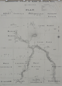
Plan, Underground Survey of Mines at Spring Hill, 1886
Plan printed by the Government Printing Office Melbourne, of underground survey at Spring Hill underground survey, spring hill, robert allen, c.w. langtree, steam litho government printing office