Showing 694 items
matching reef mining
-
 Bendigo Historical Society Inc.
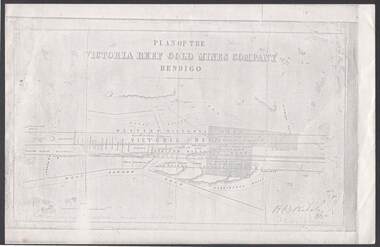
Document - VICTORIA REEF GOLD MINES COMPANY BENDIGO PLAN
Photocopy of a Plan of the Victoria Reef Gold Mines Company, Bendigo. Shaded area is the Victoria Reef Gold Mines Company Lease No. 2 and Lease No. 3. The gullies are named Happy Valley, Long, Derwent, Providence and Ironbark Gullies. The reefs are: Western Victoria, Victoria, Eastern Victoria and Prince Albert Reef. Between the Eastern Victoria Reef and the Prince Albert Reef is the White Lead. Mount Korong Road is at the bottom of the plan. Other Leaseholders are: Burrows, Wybrant, Ballerstedt, Jackson,Roberts & Co, Ashley, Grant, ?rpe, ?eau, Woodward, Coath, Taylor, Cranshaw, Roberts, Gould & Co, Midway, Witscheibe, Endeavour Co, Albert Co, Ballerstedt & Son, Late Iron Bark Quartz Mining Co, McDougall, Specimen Hill Co, Hygrect?, Wheadon, Evans and Bannerman. Signed by H. B. Nicholas. Location of Ballerstedt, Luffsman, Midway Co, Witscheibe and Rae & Co engine locations. Hills are shown as hatch shading. Written at the bottom left ocrner is: Accompanying prospectus issued in Nov. 1859. Signed H.B. Nicholas.plan, bendigo, victoria reef gold mines company, victoria reef gold mines company bendigo - plan, h b nicholas, burrows, wybrant, ballerstedt, jackson, roberts & co, ashley, grant, ?rpe, ?eau, woodward, coath, taylor, cra-shaw, roberts, gou-d & co, midway, witscheibe, endeavour co, albert co, ballerstedt & son, late iron bark quartz mining co, mcdougall, specimen hill co, hyo?, wheadon, evans, bannerman. -
 Bendigo Historical Society Inc.
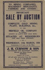
Document - IAN DYETT COLLECTION: AUCTION CATALOGUE - MIDFIELD OIL COMPANY (KNOWN AS LANE'S REEF GOLD MINE)
Grey covered auction catalogue with dark blue printing for a sale of the Complete Gold Mining Plant, Buildings, &c. of the Midfield Oil Company No Liability (Known as Lane's Reef Gold Mine), situated one mile from the Township of Wedderburn. Sale was held on the 11th March, 1936 under instructions from the Liquidator, Mr. D. R. S. McGregor (McGregor & Court). J. H. Curnow & Son were the auctioneers and the catalogue was printed by Boltons Print, Bendigo.business, auctioneers, j h curnow & son pty ltd, ian dyett collection - auction catalogue - midfield oil company no liability (known as lane's reef gold mine), j h curnow & son, mr d r s mcgregor, mcgregor & court, boltons's print bendigo -
 Bendigo Historical Society Inc.
Document - Fortuna Bendigo, letter of re classification by the National Trust and History Brochure, 20/10/2008
The Fortuna Villa is an expansive Victorian mansion built entirely on the profits of Bendigo's lucrative gold reefs. Established by the wealthy Ballerstedt family in the 1860s, it was purchased and expanded in the 1870s by George Lansell, who was to become one of Australia's wealthiest men. Fortuna villa and gardens were once occupied and cared for by the Australia Army Survey Regiments since 1942 for over thirty years.Classification Report and Notes on the history of Fortuna from the National Trust to the Bendigo Council 20th October 2008; tourist brochure for Fortuna; it includes photographs and detailed history of George Lansell's involvement in the property and his mining history.history, national trust bendigo collection, bendigo, fortuna, george lansell, mining -
 Bendigo Historical Society Inc.
Financial record - St. Mungo Gold Mining Company
Book of shares receipts. The receipts are numbered from 1751 to 2000 only the first four are detached, all are blank. The words on the receipt are: extended St. Mungo Gold Mining Company No-Liability St. Mungo's Reef, Eaglehawk. Registered under the mining companies' act, 1871. Capital: pounds 7,500 in 30,000 shares of five shillings each.st.mungo mine, gold mine, shares receipts -
 Bendigo Historical Society Inc.
Financial record - St. Mungo Gold Mining Company
Book of shares receipts. The receipts are numbered from 1701 to 1750 only the first seven are detached, all are blank. The words on the receipt are: extended St. Mungo Gold Mining Company No-Liability St. Mungo's Reef, Eaglehawk. Registered under the mining companies' act, 1871. Capital: pounds 7,500 in 30,000 shares of five shillings each.st.mungo mine, gold mine, shares receipts -
 Bendigo Historical Society Inc.
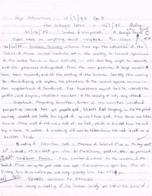
Document - PETER ELLIS COLLECTION: NOTES FROM BENDIGO ADVERTISER
Notes, some taken from the Bendigo Advertiser 10/71895, 12/7/1895, and 23/12/1885. Items mentioned are: Snakes of the Whipstick, Science Society, Elliott's Reef Company, Sandhurst Museum, Snakes common to Bendigo, Snake Bite, The Whipstick Water Supply - Bendigo Advertiser 23/12/1885, Are Slides guides to Mining, Mr Wilson Froggatt's return from New Guinea, Death and a short obituary of Dr MacGillivray, Some of the work of watercolour and pencil artist, Mr R H Nancarrow, of Neilborough, and a description of Dr Mac's new residence on the lower corner of Rowan and Forest Streets.bendigo, history, early bendigo, peter ellis collection, bendigo advertiser 10/7/95 pg 3 & 12/7/95, snakes of the whipstick, school of mines, r brough smyth, science society, dr macgillivray, eaglehawk prospecting committee, elliott's reef company, sandhurst museum, prof halford, mr r bloomfield rees, professor mccoy, mr vahland, mr robshaw, the whipstick water supply, bendigo advertiser 23/12/1885, mr nancarrow, mr wilson froggatt, sir edmund strickland, geographical society, paul howard, isabella shields, sandhurst mining board, mr r h nancarrow - artist - watercolour & pencil, arnott's patent ventilators -
 Bendigo Historical Society Inc.
Document - MCCOLL, RANKIN AND STANISTREET COLLECTION: SUNDRY REPORTS, 1930's
Manilla Folder containing reports from various mines in Bendigo and surrounding areas. 1. 4 page typewritten report on the Balaclava Hill Mine at Rushworth and some newspaper clippings about the mine with a plan of the underground workings; 2. Page from the Árgus' dated 2nd August 1900 featuring an article on the survey of the Garden line of Reefs; 3. 5 page report with maps on the Tooleen Gold Field; 4. Single page report about an unnamed mining area claimed to be on the southern end of the Deborah line of reef. (this could be the 'Three Jays' mine in Sedgwick. P. Wilkin); 5. Hand written report on the Coronation Mine, 2 miles east of Walhalla.; 6. Hand written report dated 1935, of the Queen Mary mine, St. Arnaud.; 7. 1932 report on the North Neangar lease.; 8 4 page report on the Kings Prize Gold Mining Syndicate.; 9. Description of the plant of the Marong Alluvial Company? Also a guide for marking out leases.; 10. Crushing details (1 page) from the 'Enterprise' Mine South of and adjacent to Perseverence.; 11. 1 page crushing details from Rowe Brothers, Mosquito Mine, Fryerstown.; 12 hand written report mentions Arthur Hatfield, Scarsdale.; 13. Map with lines of reef showing the position of the New Moon Consolidated and the New Moon United shafts.; 14, Large scale map from Harrison/Victoria street to Havilah Road showing the positions of the Carlisle, North Garden and Unity Shafts.gold mining, miners' safety cage, sundry reports, mining. bendigo, rushworth, balaclava hill, garden line of reef, toolleen, coronation mine, walhalla, queen mary mine, st. arnaud. north neangar, kings prize gold mining syndicate, marong, enterprise mine, perseverence, rowe brothers, mosquito mine, fryerstown, arthur hatfield, scarsdale, new moon consolidate, new moon united, carlisle, north garden, unity. -
 Bendigo Historical Society Inc.
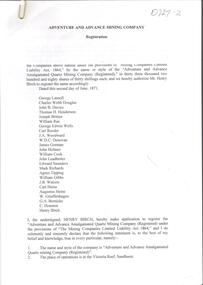
Document - Phyllis Toy Collection: 'Adventure and Advance Mining Company'
This company was registered in May 1871. It amalgamated the Adventure, Advance and Try-me-well mines to mine below the 300 foot levels of these mines.Collection of Government Gazette and newspaper articles relating to the 'Adventure and Advance Amalgamated Quartz Mining Company' on the Victoria Reef, Sandhurst. . Papers include the registration notice of the Mine in 1871, detailing the shareholders. Half yearly meeting reports 1872 - 1880 are attached. Slip of paper attached to each item describes the content, for example 'Half yearly meeting reports of the Adventure and Advance Company as published in the Bendigo Advertiser from 30.1.1872 - 31.8.1880. Missing February 1873, February 1877. Also included, Victoria Consols Company Reports 31.8.1880.adventure gold mine, sandhurst, goldmining, adventure and advance amalgamated quartz mining company -
 Bendigo Historical Society Inc.
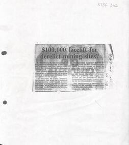
Newspaper - Kangaroo Flat Gold Mine Collection: Article, Facelift for Derelict Mining Sites, 6th November 1985
Newspaper article, (photocopied onto A4 paper) Bendigo Advertiser November 6th, 1985, headed '£100,000 facelift for derelict mining sites?' Article describes how the Bendigo Council were seeking a loan from the Goldfields Revolving Fund for the restoration of the Victoria Hill area and for the restoration of the relics and poppet legs of the Central Nell Gwynne, the Nell Gwynne Reef Mine, the North Deborah and the Big Deborah Mine sites.Written in black pen on right hand side: B'go Adv. Nov. 6th. '85gold mining, nell gwynne mine, north deborah mine, big deborah mine, poppet legs, bendigo, restoration -
![View of the Township of Mt. Blackwood / [by] Nicholas Caire, circa 1876](/media/collectors/550653872162f11fb04854aa/items/57830cfbd0cdd1176c424e00/item-media/57830d7ad0cdd1176c428423/item-fit-380x285.jpg) Kew Historical Society Inc
Kew Historical Society IncPhotograph, Anglo-Australasian Photographic Company, View of the Township of Mt. Blackwood, c. 1876
Nicholas Caire was born on Guernsey in the Channel Islands in 1837. He arrived in Adelaide with his parents in about 1860. In 1867, following photographic journeys in Gippsland, he opened a studio in Adelaide. From 1870 to 1876 he lived and worked in Talbot in Central Victoria. In 1876 he purchased T. F. Chuck's studios in the Royal Arcade Melbourne. In 1885, following the introduction of dry plate photography, he began a series of landscape series, which were commercially successful. As a photographer, he travelled extensively through Victoria, photographing places few of his contemporaries had previously seen. He died in 1918. Reference: Jack Cato, 'Caire, Nicholas John (1837–1918)', Australian Dictionary of Biography.An original, rare photograph from the series 'Views of Victoria: General Series' by the photographer, Nicholas Caire (1837-1918). The series of 60 photographs that comprise the series was issued c. 1876 and reinforced a neo-Romantic view of the Australian landscape to which a growing nationalist movement would respond. Nicholas Caire was active as a photographer in Australia from 1858 until his death in 1918. His vision of the Australian bush and pioneer life had a counterpart in the works of Henry Lawson and other nationalist poets, authors and painters.‘View of the Township of Mt. Blackwood’ : Views of Victoria (General Series) No.42 : Albumen silver photograph | Photo on card with Title and Description on reverse | Mounted 24 x 30 cm; Photo 12 x 17 cm.On Reverse: ‘The locality which this illustration represents was formerly known as the Blackwood Forest, and has been the scene of considerable mining activity. The shallow alluvial diggings of the early days have given place to the deep sinking in search of reefs. This scene is characteristic of the wild appearance which many of the inland townships of Victoria represent.’nicholas caire (1837-1918), blackwood (vic), mount blackwood, landscape photography - victoria -
![View of the township of Golden Square / [by] Nicholas Caire, circa 1876](/media/collectors/550653872162f11fb04854aa/items/578340aed0cdd1176c6899f4/item-media/5783411dd0cdd1176c68c568/item-fit-380x285.jpg) Kew Historical Society Inc
Kew Historical Society IncPhotograph, Anglo-Australasian Photographic Company, View of the township of Golden Square, c. 1876
Nicholas Caire was born on Guernsey in the Channel Islands in 1837. He arrived in Adelaide with his parents in about 1860. In 1867, following photographic journeys in Gippsland, he opened a studio in Adelaide. From 1870 to 1876 he lived and worked in Talbot in Central Victoria. In 1876 he purchased T. F. Chuck's studios in the Royal Arcade Melbourne. In 1885, following the introduction of dry plate photography, he began a series of landscape series, which were commercially successful. As a photographer, he travelled extensively through Victoria, photographing places few of his contemporaries had previously seen. He died in 1918. Reference: Jack Cato, 'Caire, Nicholas John (1837–1918)', Australian Dictionary of Biography.An original, rare photograph from the series 'Views of Victoria: General Series' by the photographer, Nicholas Caire (1837-1918). The 60 photographs that comprise the series were issued c. 1876 and reinforced a neo-Romantic view of the Australian landscape to which a growing nationalist movement would respond. Nicholas Caire was active as a photographer in Australia from 1858 until his death in 1918. His vision of the Australian bush and pioneer life had a counterpart in the works of Henry Lawson and other nationalist poets, authors and painters.‘View of the township of Golden Square’ : Views of Victoria (General Series) No.57 : Albumen silver photograph | Photo on card with Title and Description on reverse | Mounted 24 x 30 cm; Photo 12 x 17 cm.On Reverse: ‘This Township is situated in the Bendigo district, on the road to Castlemaine, and although it is of little importance as a business town, is nevertheless of large importance in consequence of the great number of Quartz Reefs it contains. Almost every house is undermined, and large fortunes have been made by the proprietors. The Church in the distance is that of the Wesleyan body. It was in this township that gold was first discovered in the district of Bendigo.’nicholas caire (1837-1918), golden square (vic), bendigo (vic), gold mining, landscape photography - victoria -
Stawell Historical Society Inc
Archive, Crown Cross Reef Gold Mine Co & Extended Crown Cross, Share Register, 1868
Listing NamesHand Writtenstawell, mining -
 Stawell Historical Society Inc
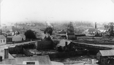
Photograph, Panorama Of Stawell from Big Hill looking North West 1878 Mines Visible
... Reef Poppet Heads. stawell mining Victorian Views. C. Herbert ...On very left behind the winding engine shed in the foreground is the South Cross Mines No8 & No9. The next mine to the right not counting the Whims is the Crown Cross United Mine with curved tramway. Tyne Reefing Company is barely visible at centre of image in front of left end of settling dam. The Great Northern is centre right of image, Extended Cross Reef Mine, then Oriental Mine, the Grant Lamont Battery and two Pleasant Creek Cross Reef Poppet Heads.Scotchmans United Quarts Mining Company 1878Victorian Views. C. Herbert, Photo. Stawell 1878stawell mining -
 Stawell Historical Society Inc
Photograph, Oriental Gold Mining Company c1880's. Mining Scene looking North probably from Fire Station Tower
Mining Scene looking North probably from Fire Station. Grant and Lamont's Battery in corner left side, in background of photograph. In Centre right is No1 North Cross Reef Mine. On left behind the tree is No2 North Cross Reef Mine. On right is Oriental Mine.Houses and yard in foreground. Poppet heads to right of centre and right Crushing Battery on left of image.stawell mining -
 Stawell Historical Society Inc
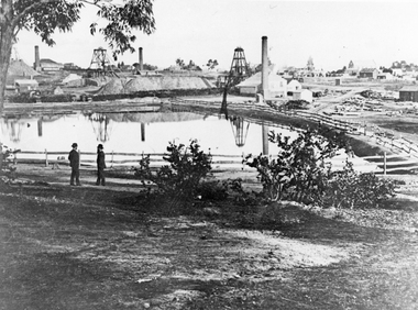
Photograph, The Pleasant Creek Cross Reef No1 Shaft Panorama of a Mining Scene in the Duke Sands area c1875
Mining Scene Duke Sands area c1875 Behind the tree on left is Extended Cross Mine and on the right is the Oriental Mine. In the centre is the North Cross Mine No1 shaft. In the foreground is one of the Moonlight dams. St Peters Lutheran Church in Scallan Street can be seen on the right horizon. Two mines and workings on other side of Moonies settling dam. Two Gentlemen lower left cornerstawell mining -
 Stawell Historical Society Inc
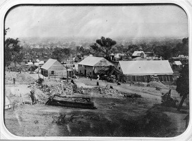
Photograph, The Reef Hotel Pleasant Creek 1858 - 1861 -- note, no Bullock team as in Rees painting
The Reefs Hotel Pleasant Creek. 1858 - 1861 (note, no Bullock team as in Rees painting) Three windlasses over mineshafts can be seen, two on the left and one in front of the assembly hall. Some horse driven Whims can be seen in the background above the Assembly Hall.One of earliest known photographs of Pleasant CreekSeveral buildings in mining area with trees in background, one building labelled The Reefs Hotel. Spoil heaps in foreground with other mining activities . Number of people visible in street.stawell -
 Stawell Historical Society Inc
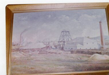
Photograph, Famous North Cross Reef Gold Mine painting by Mr Will Rees
North Cross Reef Gold Mine painted by Will Rees Colour Photo of Framed Paintingstawell mining -
Stawell Historical Society Inc
Archive, et al, Flying Doe Reefing Coy 1868 - 1871. Front Section holds details of S. Isaacson Store Daily Sales, 1868 - 1871
Pages 1-117 (Back Section) Have been photocopied and are stored in the "Flying Doe" Mines File Rm2Green Cover Red Bound Bookstawell, mining, business -
 Stawell Historical Society Inc
Photograph, Double story building on left is Lamont Crushing Battery & on the right is the Oriental Mine looking from the top of the Fire Station c1880's
Photograph taken from the top of the Fire Station 1880's Double story building on left is Lamont Crushing Battery. Behind tree North Cross Reef Mine. Centre No 1 North Cross Reef Mine. On right Oriental Mine.stawell mining -
 Stawell Historical Society Inc
Photograph, Extended Cross Reef Mine 1870’s-1980's
... Mining - Extended Cross Reef Mine 1870’s-1980's... grampians Mining - Extended Cross Reef Mine 1870’s-1980's Stawell ...Mining - Extended Cross Reef Mine 1870’s-1980'sstawell -
Stawell Historical Society Inc
Archive, South Cross Reef Quartz Mine Co Ltd – Mining Memorabilia etc, 1881 - 1888
Large Share Register BookSouth Cross Reef Q.M. Co. Limited Stawellstawell -
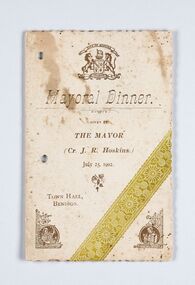 City of Greater Bendigo - Civic Collection
Memorabilia - Event Program, City of Bendigo, Mayor Dinner, 1902
John Robert Hoskins was a Councillor with the City of Bendigo from1888 - 1902 and Mayor from 1901 - 1902. Hoskins' interests in the region included the mining company Hoskins & Co, which distinguished itself on the late Derwent Reef United Company's leased ground in 1868 by achieving a yield of over an ounce to the ton. In the late 1870s John R. Hoskins formed a estate agency in partnership with Frederick Illingworth. He was also manager of the New Nil Desperandum, formed to work the shaft of the old Raywood mine, from 1906 to 1908. Event program for the Mayoral Dinner July 25, 1902. Gold, green and brown ink on cream card. Half fold with menu printed inside and Toast List on back cover. Scalloped edges.Front cover: (Picture) Bendigo Coat of Arms / Mayoral Dinner / Given by / The Mayor / (Cr .J. R. Hoskins) / July 25, 1902 / Town Hall / Bendigo bendigo town hall, making a nation exhibition, c roberts caterer, mayor j. r. hoskins, councillor j. r hoskins, mayoral ball, city of greater bendigo events, city of greater bendigo ceremonial item -
Tarnagulla History Archive
Set of Maps (Mining & Local Area), various
David Gordon Collection. A set of mining documents, maps and plans: 1. Dunolly Deep Leads - showing location and names of deep lead gold deposits in region around Dunolly including at Tarnagulla and Newbridge. Geological Survey of Victoria, Department of Minerals and Energy. Bulletin No. 62, Map No. 4 Dunolly (770 x 485 mm). 2. Poseidon Lead (Facsimile) 3. Nick O Time Lead (Facsimile) 4. Happy Go Lucky Mine prospectus and plan (colour copy) 5. Jones Creek GM Co. (Raven & Gourlay's) Waanyarra - Prospectus (colour copy) 6. Poseidon Area Plan (colour copy) and Poseidon Area map (B&W copy). 7. Cross-section diagram of Spread Eagle Reef 8. New Birthday Gold Mine - area map (colour copy) and mine cross-section ( (colour copy). 9. Cross section of Poverty Reef, by Department of Mines (B&W copy, 2 parts on A2 paper) 10. Time-Lease Graph for Watts Reef, Specimen Reef, Stony Reef, Poverty Reef (second page in detail), created by Eric WIlkinson for Ref Mining NL, 1995 11. 1859 Plan of the Gold Workings & Township of Sandy Creek, Shewing the Mining Leases, Extended Claims & Machinery by R.J. McMillan, Mining Surveyor (B&W copy) 12. Longitundinal and Transverse Vertical Sections of Poverty Reef, Sandy Creek 1859, by R.J. McMillan, Mining Surveyor (B&W copy) 13. Tarnagulla Locality Plan (B&W copy) 14. Universal Grid Reference Map (Topographic) for Laanecoorie North (2 copies) 15. Universal Grid Reference Map (Topographic) for Inglewood South 16. Poverty Reef, Plan showing shafts and early tenements, created by Eric WIlkinson for Ref Mining NL, 1995 17. Locality Map of mining leases in Tarnagulla 18. Plan and Elevation of part of Poverty Reef, Sandy Creek, showing the claims and positions of the shaft. by R.J. McMillan, Mining Surveyor (Facsimile, composed of taped together components) 19.Plan and Elevation of part of Poverty Reef, Sandy Creek, showing the claims and positions of the shaft. by R.J. McMillan, Mining Surveyor (Facsimile, composed of taped together components) -
Tarnagulla History Archive
Photograph: Headframe on rehabilitated Poverty Reef Shaft, Tarnagulla, 1999
Shaft originally sunk in 1859. David Gordon Collection. Colour photograph depicting the headframe on the former Poverty Reef Shaft, Tarnagulla in 1999 after the shaft was rehabilitated by Western Mining Corp for use as a ventilation and safety shaft. mining -
Tarnagulla History Archive
Photograph: Winder gear on rehabilitated Victoria Shaft, Poverty Reef, Tarnagulla, 1999
Shaft originally sunk in 1863. David Gordon Collection. Colour photograph depicting winder gear for the Victoria Shaft on Poverty Reef, Tarnagulla in 1999 after the shaft was rehabilitated by Western Mining Corp. mining -
Tarnagulla History Archive
Photograph: Support timbers from Poverty Reef, Tarnagulla, 1999
The timbers date from 1898 when the shaft was re-lined by the Bendigo Consols Company. David Gordon Collection. Colour photograph depicting a stack of support timbers after they were removed from the Poverty Reef shaft, Tarnagulla in 1999 by Western Mining Corp. mining -
Tarnagulla History Archive
Research file: New Chum Claim, Poverty Reef, August 1995
David Gordon Collection. Research file: New Chum Claim, Poverty Reef by Eric WIlkinson.mining -
Tarnagulla History Archive
Photograph - Photograph: Workers at Bendigo Consols Company N.L. on Poverty Reef, c.1898
Williams Family Collection. Photographer J.P. Lind also made an image at Shelbourne which is now in Museums Victoria collection: https://collections.museumsvictoria.com.au/items/767776 Monochrome photograph of workers at Bendigo Consols Company N.L. on Poverty Reef. An original photograph, mounted on card. Photographer's mark on reverse: "J.P. Lind Photographer Melbourne"tarnagulla, people, mining