Showing 6784 items matching "river"
-
 Lakes Entrance Historical Society
Book, Rob Christie, Cargo Crooked River 1984 edition, 2000
This updated edition gives a broader picture of life on the Dargo Crooked River goldfields, Illustrated with photographs and maps.mines and mining, township -
Lakes Entrance Historical Society
Book, Davidson, Rachael, The Nicholson River Railway Bridge, 2004
Research, interpretation and management recommendations for the Nicholson River Railway Bridge, East Gippsland, Victoria, by a Forestec student.bridges, transport -
Lakes Entrance Historical Society
Book, Van der Heyden Becky, Calulu Mitchell River Bridge, 2004
Research interpretation and management recommendations for the Calulu Mitchell River Bridge, near Bairnsdale, Victoria by a Forestec Studentbridges, waterways, settlers -
 Lakes Entrance Historical Society
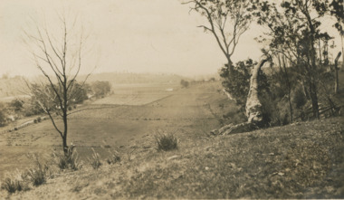
Photograph - river flats at Tambo Upper near Bruthen Victoria, 1925
Sepia toned photograph of river flats at Tambo Upper with maize crops in distance, glimpse of Bruthen VictoriaJanuary 1925 Honeymoon trip on backagriculture -
 Lakes Entrance Historical Society
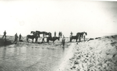
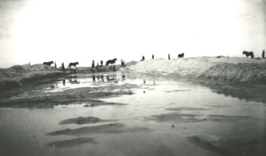
Photograph - Snowy River Marlo Victoria, 1940 c
No 4 in series of fiveBlack and white photograph of workmen with horses and scoops opening an entrance at mouth of the Snowy River Marlo Victoriaenvironment, waterways, public works, rivers -
 Orbost & District Historical Society
newspaper clippings, 1928 - 1975
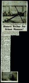
These newspaper articles were collated by Mary Gilbert. Mary Isabelle Gilbert was born in 1905 in Orbost, Australia. She was born to John Gilbert and Annie Cameron Gilbert, and had seven sisters and one brother. Four siblings died at a young age. She was a teacher historian loved and respected by her family and the wider community.These articles are contemporary records of events in the history of Orbost and as such are useful reference tools.A manila folder containing black / white newspaper cuttings of articles relating to the local history of Orbost. They are from the Snowy River Mail. 746.1 is titled, "Historic anchor for Orbost Museum". 746.2, August 9, 1967, is titled, ""Orbost Historical Museum". 746.3 is titled, "When The Snowy Was Angry". On the back is "Resident's Sudden Death - Mrs Ada Bowtell (67)". 746.4 from 1934 is titled, "The Duke's Visit - Welcome at Cann River'. 746.5, Wednesday November 24, 1954 is titled, "Naming of Orbost District Landmarks". 746.6, Wednesday November 24, is titled, " Convict First White Settler in Orbost District?". 746.7, Wednesday, July 25, 1928 is titled, " Dedication of St James' Memorial Church, Orbost". 746.8 and 746.9, Wednesday September 24, 1975 are titled, "Piece of History Returns".orbost- museum anchor-orbost street-names-orbost st-james'-orbost -
 Orbost & District Historical Society
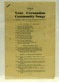
booklet, Your Coronation Community Songs, 1953
This booklet was printed by the Snowy River Mail newspaper to be used at a community event celebrating the Coronation of Her Majesty Queen Elizabeth II in the Abbey Church of St. Peter, Westminster, on Tuesday, the second day of June, 1953. The coronation of Queen Elizabeth 11 was a significant event in 1953. This booklet is representative of a community event.A booklet containing word of songs for a community celebration of the coronation of Queen Elizabeth 11. It is titled "Your Coronation Community Songs". For Tuesday June 2 1953 at 7.45pm.coronation booklet-songs souvenir -
 Eltham District Historical Society Inc
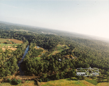
Photograph, Yarra River, Sweeneys flats, 1994c
Colour photogrpah of oblique aerial view looking east over Yarra River and Sweeneys flats c.1994sweeneys lane, yarra river, culla hill, thomas sweeney, aerial photographs -
 Wangaratta Art Gallery
Painting, Robert Horne, Overlooking the Howqua River, 1975
Rural City of Wangaratta Collection, Wangaratta Art Prize 1976.An aerial landscape depicting the Howqua River painted in synthetic polymer in shades of green, yellow, blue, brown, and white.Obverse: R HORNE 75/ (bottom right corner)wangaratta art gallery, robert horne, landscape, painting, howqua river -
 Peterborough History Group
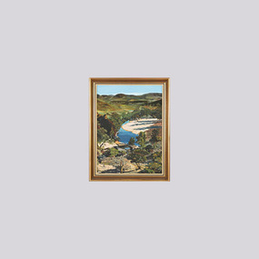
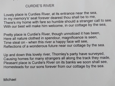
Document, James Meek et al, Curdies River, a poem
James Meek was one of the original settlers in the area. This poem is attributed to him.Poem showing James Meek's attachment to this area and in particular for the Curdies River estuary. Print out of an email from Michael Moore to Maree O'Connor with a poem called Curdies River by James Meekpeterborough, curdies river, james meek, curdies river estuary -
 Lakes Entrance Historical Society
Photograph - Snowy River Marlo Victoria, 1940 c
No 5 in series of fiveBlack and white photograph showing men with horses and scoops opening an entrance to mouth of Snowy River Marlo Victoria public works, vegetation, rivers -
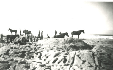 Lakes Entrance Historical Society
Photograph - Snowy River Marlo Victoria
No 2 in series of fiveBlack and white photograph showing men and horses with scoop opening an entrance to the mouth of the Snowy River Marlo Victoriaboats and boating, jetties, rivers -
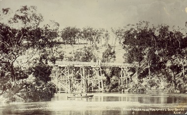 Kew Historical Society Inc
Postcard, J.W.K. & Co, River Yarra near Macauleys' Boathouse Kew, c.1910
The Zig-Zag Bridge which was constructed in the 1870s to link the Yarra Bend Asylum and Kew Asylum. Initially it transported bluestone from the west side of the Yarra to the east during the construction of the Kew Asylum.Real photo postcard of the Zig-Zag Bridge at Kew. In the middle ground there is a rowboat.Obverse: "River Yarra near Macauleys' Boathouse Kew". Reverse: "Gift from L Bennett"bridges -- river yarra, bridges - kew (vic.), zig-zag bridge -
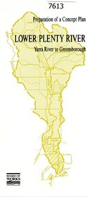 Greensborough Historical Society
Pamphlet, Melbourne & Metropolitan Board of Works, Lower Plenty River: Yarra River to Greensborough: preparation of a concept plan, 1990
This pamphlet outlines a proposed concept plan for the lower Plenty River, Greensborough to Heidelberg. The plan would focus on preserving and enhancing the aesthetic, recreational and conservation potential of the waterway.2 p., illus., tri-fold pamphlet. 2 copiesplenty river, melbourne water corporation, board of works -
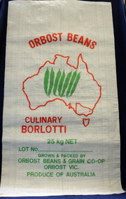 Orbost & District Historical Society
seed bag, mid 20th century
Orbost Beans & Grains Co-Op was an extension of Snowy River Sweet Corn Co-Op which also sold fresh produce such as corn, squash, zucchini and cucumbers. This bag is unused and would have been packed with borlotti beans.Snowy River Seeds started life as a farmers' co-operative (Snowy River Co-op) in 1967. This item is significant because it was specially made for the seed bean industry which was a major industry in the Orbost district for over a century. A white woven synthetic bag used for packing borlotti beans. Inside a red outline of Australia are seven green beans. Victoria is outlined and Orbost is indicated with a red d t. Print is red and green. On front : Grown & Packed By Orbost Beans & Grain Co-Op 25 kg Orbost Victoria Produce of Australia seed-bag snowy-river-co-op agriculture farming orbost-beans -
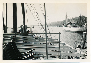 Mission to Seafarers Victoria
Photograph - Photograph, Black and white, Allan Charles Quinn, Passing ship on Elbe River, 4 June 1950
This series of photographs captures life at sea and the conditions on the ship M/S "Mongabarra" Goteborg in 1950.This photograph is part of the Allan Quinn collection, which is a pictorial autobiography, and it represents one of many moments of his time abroad as a seafarer.Black and white photograph of the Elbe River in Germany. In the foreground is a lounge area with chairs and railing. Behind this are masts, rigging and rope near what appears to be a jetty with partial roofing. In the middle ground is the Elbe River running from the bottom right to middle left of the photograph. In the background is a passing ship and a mountain.germany, 1950, ship, deck, mast, chairs, mongabarra, allan quinn collection, allan quinn, tailing, elbe river, mointain -
Clunes Museum
Artwork, other - LITHOGRAPH, Adelaide, From the River Torrens
Dark sepia scene, on linen surface paper. Depicting Torrens River, with bridge and city buildings in background. Tree lined banks, 2 figures on left bank and 3 rowing boats on river. 4 figures on right bank. Picture is mounted on 10mm thick chipboard which is coloured black.Scheil - A Irwin Sclithograph, torrens river -
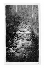 Marysville & District Historical Society
Photograph (item) - Black and white photograph, Mabel Russell Sutherland, December 1935
A black and white photograph of the Taggerty River near Marysville in Victoria.A black and white photograph of the Taggerty River near Marysville in Victoria.SUTHERLAND/ STUDIO/ HEALESVILLE Taggerty River/ Dec. 1935 19taggerty river, marysville, victoria, photograph, mabel russell sutherland, sutherland studio -
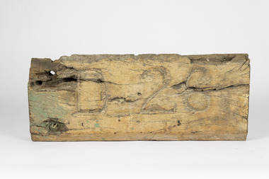 Port of Echuca
Plaque - Timber sign, Murray River Sawmills, 1926
This large wooden sign was originally attached to the barge D26 which was one of the 4 barges used to carry logs behind the PS Adelaide. The D indicated that it was the fourth barge to be built in 1926 by Murray River Sawmills. The number represented the year it was built.This original timber piece, salvaged from the D26 barge is an important relic from an original outrigger logging barge from the early 20th century, one of the last logging barges built as the Murray River timber trade was declining. The barge was restored by the Port's chief shipwright Kevin Hutchinson with assistance from Laurie Rendle and Alan Battsch. and the PS Adelaide is also a significant feature in the Port's collection. Large red gum timber signD 26d26, barge, logging industry, murray river sawmills, ps adelaide -
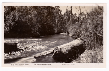 Marysville & District Historical Society
Postcard (item) - Black and white postcard, Rose Stereograph Company, The Stevenson River, Marysville, Vic, 1913-1967
A postcard in a series produced by the Rose Stereograph Company in Victoria, Australia as a souvenir of Marysville.A black and white photograph of the Stevenson (Steavenson) River that runs through Marysville in Victoria. The Steavenson River is named after the Victorian Assistant Commissioner of Roads and Bridges, John Steavenson who arrived here in the early 1860s.POST CARD The "Rose" Series/ De Luxe A Real Photograph/ Produced in Australia Published by the Rose Stereograph Co.,/ Armadale, Victoriastevenson river, steavenson river, marysville, victoria, p. 4945, rose series postcard, postcard, souvenir, john steavenson -
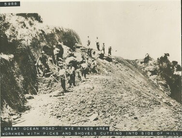 Lorne Historical Society
Photograph, Workmen with hand tools Great Ocean Road near Wye River
Photograph of G,O,R. construction area at Wye River, showing construction worker cutting into the side of the hill with picks.g.o.r.; wye-river; construction-workers; -
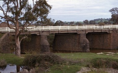 City of Whittlesea
Photograph - Photographs - Bridges, Moses Thomas bridge over the Plenty River 1970, 1970
Bluestone bridge across the Plenty River, Mernda. Commissioned by Moses Thomas, Secretary Morang District Road Board 1867bridges, moses thomas, mernda, bridge inn road -
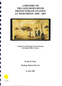 Victorian Aboriginal Corporation for Languages
Book, Ian D Clark, A history of the Goulburn River Protectorate Station at Murchison, 1840-1853 : a report to the Heritage Services Branch, Aboriginal Affairs Victoria, 1999
Contains histories of the Aboriginal Protectors in the Goulburn River area and their work with the people in this region using journal entries and historical records.maps, b&w photograph, colour illustrations, tables -
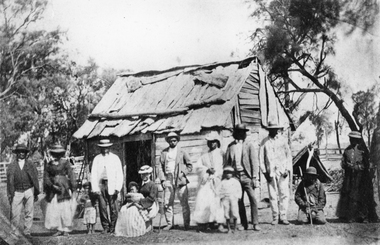 Stawell Historical Society Inc
Photograph, Indigenous or First Nations People at Carrs Plains 1874 Richardson River Tribe
Photo taken at Carrs Plains in 1874 of Indigenous or First Nation People outside a wood and bark hut. In 1861, William Dennis of Carrs Plains Station, a staunch Methodist became Honorary, Aboriginal Protector for the area. One of his main tasks to give Government supplied food and clothing to the Aboriginals. Many district, remaining Aborigines became based at Carrs Plains, and their dead were buried in a cemetery on the station. The cemetery is show on survey map of Wirchilleva Borough, in corner of camping & water reserve near surveyed Bismarck township. In a Protector's report 1869, Dennis wrote that only one male worked regularly on the property, a Bullock driver.Black and white photograph of a wood and bark hut with a group of men, women and children out the front. Richardson River Tribe.Anthony & Lubra, Donald & Affie my ? Herbal? Black Billie Great Rider, Kitty Supulants? Lubra Jonny Callaghan Jr., Four? Supulant? Harry, Blind Tommy & Lubra, 1874 Reproduction rights reserved Copied by State Library of Victoriastawell aboriginal portrait -
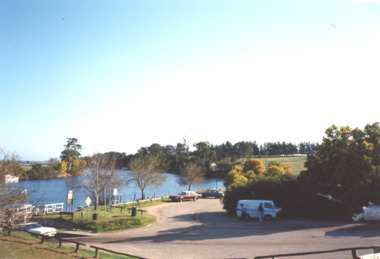 Lakes Entrance Historical Society
Photograph, M Holding, Jetty and boat ramp Tambo River Johnsonville 1999, 1999
Colour photograph of Johnsonville jetty boat ramp and parking area before installation of new jetty on Tambo River Johnsonvillehouses -
 Bendigo Military Museum
Photograph - 4th Field Survey Squadron – Operation NERVOSE 85 Field Phase, Northern Territory, 1985
This is a set of 16 photographs taken in 1985* during 4th Field Survey Squadron’s deployment on Operation NERVOSE 85 in the Northern Territory. Operation NERVOSE 85 was mounted by 4 Fd Svy Sqn in the EAST ARNHEM, VICTORIA RIVER DOWNS AND DALY WATERS areas from 26 May to 18 Sep 85. The aim of Operation NERVOSE 85 was to finalise the horizontal and vertical control for mapping at a scale of 1:50,000, to field check 40x 1:50,000 preliminary maps and to obtain mapping photography in support of the RAAF TINDAL redevelopment project. *Note –These photos were most likely taken in 1985, contrary to the ‘1987’ date annotated on the negative sleeves. The Op NERVOSE 85 Project Report available on RASVY’s web site lists a nominal roll of personnel. Photos of 4 Fd Svy Sqn taken in 1985 and 1987 provide names of posted personnel. Several personnel identified in these photos were posted to 4 Fd Svy Sqn in 1985, not in 1987. See items 6504.13P, 6505.28P and 6507.20P for more photos taken prior to and during Operation NERVOSE 1985. This is a set of 16 photographs taken in 1985 during 4th Field Survey Squadron’s deployment on Operation Nervose in the Northern Territory. The black & white photographs are on 35mm negative film and are part of the Army Survey Regiment’s Collection. The photographs were scanned at 96 dpi. ..1) & .2) - Photo, black & white, 1985. Q-store and OPS Room. .3) & .4) - Photo, black & white, 1985. Base Camp at unknown location. .5) - Photo, black & white, 1985. Personnel spectate during a social cricket match. L to R on left: CPL Andy Lucas, unidentified (x3). L to R on right: unidentified (x4), LTCOL Kevin Murphy – SO1 Svy HQ FF Comd, unidentified, SSGT Barry Lutwyche OAM (closest to camera). .6) - Photo, black & white, 1985. Personnel spectate during a social cricket match. L to R on left: unidentified (x2). L to R on right: unidentified (x3), LCPL Chris ‘Charlie’ Brown (standing up), SSGT Barry Lutwyche OAM (closest to camera), LTCOL Kevin Murphy – SO1 Svy HQ FF Comd. .7) - Photo, black & white, 1985. CPL Andy Lucas plans an exit strategy from the latrine. .8) to .10) - Photo, black & white, 1985. Social cricket match action. .11) to .14) - Photo, black & white, 1985. LCPL Chris ‘Charlie’ Brown operates a second-generation Transit Doppler satellite Magnavox MX-1502 Satellite Surveyor Geoceiver. .15) to .16) - Photo, black & white, 1985. LCPL Steve McGuiness sets up a Geoceiver antenna..1P to .16P – There are no personnel identified. ‘1987 OP NERVOSE VICTORIA RIVER DOWNS AND DALY WATERS.’ annotated on negative sleeve.royal australian survey corps, rasvy, 4 fd svy sqn, op nervose 85 -
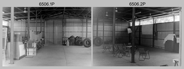
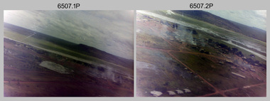 Bendigo Military Museum
Photograph - 4th Field Survey Squadron – Operation NERVOSE 85 Field Phase Oblique Photos, NT, 1985
This is a set of 20 oblique aerial photographs taken during the field phase of 4th Field Survey Squadron’s Operation NERVOSE 85 project in the Northern Territory in 1985. Operation NERVOSE 85 was mounted by 4 Fd Svy Sqn in the EAST ARNHEM, VICTORIA RIVER DOWNS AND DALY WATERS areas of the Northern Territory from 26 May to 18 Sep 85. The aim of Operation NERVOSE 85 was to finalise the horizontal and vertical control for mapping at a scale of 1:50,000, to field check 40x 1:50,000 preliminary maps and to obtain mapping photography in support of the RAAF TINDAL redevelopment project. *Note –These photos were most likely taken in 1985, contrary to the ‘1987’ date annotated on the negative sleeves. The Op NERVOSE 85 Project Report available on RASVY’s web site lists a nominal roll of personnel. Photos of 4 Fd Svy Sqn taken in 1985 and 1987 provide names of posted personnel. Several personnel identified in these photos were posted to 4 Fd Svy Sqn in 1985, not in 1987. See items 6504.13P, 6505.28P and 6506.16P for more photos taken prior to and during Operation NERVOSE 1985. This is a set of 20 oblique aerial photographs taken during the field phase of 4th Field Survey Squadron’s Operation NERVOSE 85 project in the Northern Territory in 1985. The colour photographs on 35mm negative film and are part of the Army Survey Regiment’s Collection. The photographs were scanned at 96 dpi. .1) to .20) - Photo, colour, 1985. Unknown locations..1P to .20P – There are no personnel identified. ‘1987 OP NERVOSE VICTORIA RIVER DOWNS AND DALY WATERS.’ annotated on negative sleeve.royal australian survey corps, rasvy, 4 fd svy sqn, op nervose 85 -
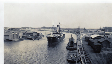 Port Fairy Historical Society Museum and Archives
Photograph
Possibly the S.S.Casino entering the riverBlack and white photograph of ship coming up rivership, boat, sea, river -
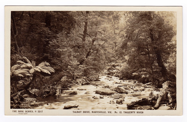 Marysville & District Historical Society
Postcard (item) - Black and white postcard, Rose Stereograph Company, Talbot Drive, Marysville, Vic. No. 12. Taggerty River, 1913-1967
A postcard in a series produced by the Rose Stereograph Company in Victoria, Australia as a souvenir of Marysville.A black and white photograph taken along Lady Talbot Drive, Marysville, Victoria, of the Taggerty River. Lady Talbot Drive is a 24 kilometer scenic rainforest car journey which passes a number of walks and waterfalls in the Yarra Ranges National Park. Lady Talbot Drive is named after Lady Sarah Elizabeth, the wife of Sir Reginald Talbot, who was the Governor of Victoria from 25th April, 1904 to 6th July 1908.REAL PHOTO POST CARD THE "ROSE" SERIES DE LUXE PRODUCED IN AUSTRALIA PUBLISHED BY "THE ROSE STEREOGRAPHS"/ Armadale, Victoria.marysville, victoria, taggerty river, p. 2317, rose series postcard, postcard, souvenir, sir reginald talbot, sarah elizabeth talbot, lady talbot drive -
 Marysville & District Historical Society
Postcard (item) - Black and white postcard, Rose Stereograph Company, Talbot Drive, Marysville, Vic. No. 12. Taggerty River, 1913-1967
A postcard in a series produced by the Rose Stereograph Company in Victoria, Australia as a souvenir of Marysville.A black and white photograph taken along Lady Talbot Drive, Marysville, Victoria, of the Taggerty River. Lady Talbot Drive a 24 kilometer scenic rainforest car journey which passes a number of walks and waterfalls in the Yarra Ranges National Park. Lady Talbot Drive is named after Lady Sarah Elizabeth, the wife of Sir Reginald Talbot, who was the Governor of Victoria from 25th April, 1904 to 6th July 1908.POST CARD The "Rose" Series/ De Luxe A Real Photograph/ Produced in Australia Published by the Rose Stereograph Co.,/ Armadale, Victoria.marysville, victoria, taggerty river, p. 2317, rose series postcard, postcard, souvenir, lady talbot drive, sir reginald talbot, sarah elizabeth talbot