Showing 2478 items
matching river street
-
 Warrnambool and District Historical Society Inc.
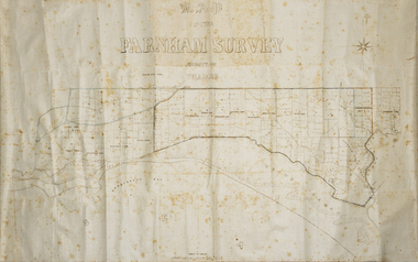
Map - Farnham Survey, 1850s
This is a map of the Farnham Special Survey. In 1843 William Rutledge purchased this Special Survey of 5,120 acres and named it Farnham. This Survey extended from Tower Hill to the Merri River at Dennington. The map appears to date from the 1850s This early map is of considerable significance as it shows details of the Farnham Special Survey. William Rutledge and his survey are important influences in the development of Warrnambool and district with the establishment of settlements at Killarney, Yangery and Tower Hill.A hand drawn map on waxed paper in brown, black and blue ink. It shows Armstrong's Bay, sea, Crown Land , the names of properties and some roads. It includes a compass direction diagram.farnham special survey -
 Eltham District Historical Society Inc
Photograph, Fay Bridge, Old footbridge, 195 Laughing Waters Road, Eltham, n.d
This old footbidge is situated close to the shack that Gordon Ford built on the Yarra at Laughing Waters Road. Bernie Bragg also used to live there for a period of time. Gordon Ford and photographer Sue Winslow were married in 1965. They set up home in an old log cabin on the property Gordon had purchased in 1954 on Laughing Waters Road. Situated between the Yarra River and Overbank Road, Gordon had built a small mud-brick shack on the river and a pontoon. Over the decades the shack has been locally referred to as “the love shack”, the “rooting shack” or simply “Gordon’s shack”. Gordon and Sue commissioned local builder Graeme Rose to do a wattle and daub renovation and extension to the old log cabin on the north side of Laughing Waters Road. The work had only just been completed in 1965 when a bushfire swept through the area and destroyed the cabin. Gordon and Sue relocated to his property, Fulling, in Pitt Street, Eltham. In 1970 work started on a new house at the Laughing Waters property. Originally known as the Banana House, it is now known as Boomerang. Designed by Alistair Knox, the mud-brick house includes iron window grilles made by Matcham Skipper that puncture the curved mud walls. The grilles were made from ‘off-pressings’ from the Sidchrome tool works in Heidelberg. Gordon, Sue and family moved into the house in 1972. Their marriage fell apart and Sue moved to Sydney with the children around the same time Gordon commenced building Birrarung just below Boomerang on the Laughing Waters Road block. After the Fords moved out, Boomerang it was rented out to various share households of students, musicians, artists and environmentalists for twenty-four years. Gordon Ford sold Birrarung and Boomerang to Melbourne Water in 1999. The Laughing Waters Artist in Residence Program was developed as a partnership between Parks Victoria and Nillumbik Shire Council. Boomerang was deemed unfit for habitation so was used as a day studio only. By 2001 Boomerang was in a poor state of repair and by 2002 the last artist in residence was to use the house as a studio. Nillumbik Shire Council had been granted funds from the Melbourne Community Fund to restore both Boomerang and Birrarung but it was apparent in early 2003 that the funds would be insufficient to restore both houses. Boomerang was infested with termites which presented a risk to any occupants and so the decision was made to close Boomerang and concentrate funding on Birrarung. Boomerang was fenced off for safety and to prevent intrusion and remains ‘caged’ today (2023). However, it is readily apparent the property has been occupied by squatters over the years. By 2023 it was clear that the squatters had abandoned the property and sections of the roof structure have given away in some areas and collapsed internally. For a more in-depth description and history of the property and that of Gordon and Sue Ford, see Jane Woollard's book, "Laughing Waters Road; Art, Landscape & Memory in Eltham" published 2016.fay bridge collection, bernie's hut, birrarung, footbridge, gordon ford, gordon's shack, laughing waters road, love shack, yarra river -
 Eltham District Historical Society Inc
Photograph - Aerial Photograph, Landata, Lower Plenty, Feb. 1956
... bounded by Pitt Street to north, Yarra River to south, Main Road... bounded by Pitt Street to north, Yarra River to south, Main Road ...Centred on present day 217 Old Eltham Road, Lower Plenty bounded by Pitt Street to north, Yarra River to south, Main Road to east and Bonds Road to west. Historic Aerial Imagery Source: Landata.vic.gov.au Aerial Photo Details: Project No :250 Project : MELBOURNE OUTER SUBURBS PROJECT Run : 17 Frame : 116 Date : 02/1956 Film Type : B/W Camera : EAG9 Flying Height : 10000 Scale : 12000 Film Number : 1176 GDA2020 : 37°43'58"S, 145°07'49"E MGA2020 : 335237, 5822186 (55) Melways : 21 E10 (ed. 42)aerial photo, 1956-02, neil webster collection, eltham, main road, bonds road, elham, lower plenty, melway 21e10, pitt street, yarra river -
 Eltham District Historical Society Inc
Photograph - Aerial Photograph, Landata, Lower Plenty, Vic, Apr. 1963
... , Lower Plenty bounded by Cromwell Street to north, Yarra River..., Lower Plenty bounded by Cromwell Street to north, Yarra River ...Centred on present day Old Eltham Road near Araluen Centre, Lower Plenty bounded by Cromwell Street to north, Yarra River to south, Main Road at Mount Pleasant Road to east and Panorama Avenue to west. Historic Aerial Imagery Source: Landata.vic.gov.au Aerial Photo Details: Project No :486 Project : MELBOURNE (1963) PROJECT Run : 7 Frame : 231 Date : 04/1963 Film Type : B/W Camera : RC8 Flying Height : 5100 Scale : 9600 Film Number : 1805 GDA2020 : 37°44'03"S, 145°07'56"E MGA2020 : 335420, 5822027 (55) Melways : 21 F10 (ed. 42)aerial photo, neil webster collection, 1963-04, araluen, cromwell street, eltham, lower plenty, main road, melway 21f10, mount pleasant road, old eltham road, panorama avenue, yarra river -
 Eltham District Historical Society Inc
Photograph - Aerial Photograph, Landata, Eltham, Vic, Apr. 1963
... by Brougham Street to north, Yarra River and Fitzsimons Lane Bridge... by Brougham Street to north, Yarra River and Fitzsimons Lane Bridge ...Centred on present day Eltham Lower Park bounded by Brougham Street to north, Yarra River and Fitzsimons Lane Bridge to south, Main Road at Kent Hughes Road to east and Bolton Street to west. Historic Aerial Imagery Source: Landata.vic.gov.au Aerial Photo Details: Project No :486 Project : MELBOURNE (1963) PROJECT Run : 7 Frame : 232 Date : 04/1963 Film Type : B/W Camera : RC8 Flying Height : 5100 Scale : 9600 Film Number : 1805 GDA2020 : 37°44'03"S, 145°08'33"E MGA2020 : 336329, 5822040 (55) Melways : 21 H10 (ed. 42)aerial photo, neil webster collection, 1963-04, bolton steet, brougham steet, eltham, eltham lower park, fitzsimons lane bridge, kent hughes road, melway 21h10, yarra river -
 Eltham District Historical Society Inc
Photograph - Aerial Photograph, Landata, Eltham, Vic, Apr. 1963
Centred on present day Griffith Park Road, Eltham bounded by Mount Pleasant Road to north, Yarra River and Templestowe to south, Main Road at Reynolds Road to east and Falkiner Street to west. Historic Aerial Imagery Source: Landata.vic.gov.au Aerial Photo Details: Project No :486 Project : MELBOURNE (1963) PROJECT Run : 7 Frame : 233 Date : 04/1963 Film Type : B/W Camera : RC8 Flying Height : 5100 Scale : 9600 Film Number : 1805 GDA2020 : 37°44'04"S, 145°09'10"E MGA2020 : 337237, 5822053 (55) Melways : 22 A10 (ed. 42)aerial photo, neil webster collection, 1963-04, eltham, falkiner street, griffith park road, melway 22a10, mount pleasant road, reynolds road, templestowe, yarra river -
 Eltham District Historical Society Inc
Photograph - Aerial Photograph, Landata, Eltham, Vic, Apr. 1972
... , Eltham bounded by Arthur Street to north, Yarra River and Kent... Road, Eltham bounded by Arthur Street to north, Yarra River ...Centred on present day Dalton Street at Mount Pleasant Road, Eltham bounded by Arthur Street to north, Yarra River and Kent Hughes Road to south, Eucalyptus Road to east and Susan Street to west. Historic Aerial Imagery Source: Landata.vic.gov.au Aerial Photo Details: Project No :985 Project : MELBOURNE 1972 Run : 28 Frame : 208 Date : 04/1972 Film Type : B/W Camera : RC10 Flying Height : 5700 Scale : 9600 Film Number : 2635 GDA2020 : 37°43'29"S, 145°08'54"E MGA2020 : 336816, 5823118 (55) Melways : 21 J8 (ed. 42)aerial photo, neil webster collection, 1972-04, eltham, arthur street, dalton street, eucalyptus road, kent hughes road, melway 21j8, mount pleasant road, susan street, yarra river -
 Eltham District Historical Society Inc
Photograph - Aerial Photograph, Landata, Eltham, Vic, Apr. 1972
Centred on present day Mays Road at Stringybark Road, Eltham bounded by Nyora Road to north, Yarra River to south, Reynolds Road to east and Bible Street to west. Historic Aerial Imagery Source: Landata.vic.gov.au Aerial Photo Details: Project No :985 Project : MELBOURNE 1972 Run : 28 Frame : 209 Date : 04/1972 Film Type : B/W Camera : RC10 Flying Height : 5700 Scale : 9600 Film Number : 2635 GDA2020 : 37°43'33"S, 145°09'28"E MGA2020 : 337647, 5823013 (55) Melways : 22 B8 (ed. 42)aerial photo, neil webster collection, 1972-04, eltham, bible street, mays road, melway 22b8, nyora road, reynolds road, stringybark road, yarra river -
 Eltham District Historical Society Inc
Document - Folder, Eltham Banner Project, 1986
Newspaper articles about the As We Are Eltham Banner Project undertaken within the Shire of Eltham 1. Eltham banner to celebrate environment, Diamond Valley News, Tuesday, September 16, 1986, p16 2. Group paints for peace, Diamond Valley News, Tuesday, September 30, 1986, p2 3. Banners show people of Eltham as they are, Diamond Valley News, Tuesday, October 14, 1986, pp12-13 4. Banners fly high at lastt, Diamond Valley News, Tuesday, October 21, 1986, p17 Also various advertisements from businesses within the shire Newspaper clippingsas we are, banner project, eltham banners, meruka house, sarah houseman, advertising, eagle screens & blinds, 1986, alistair knox park, bob manuell, don brown, dooncal air coinditioning and central heating, eltham festival, eltham outdoor art show, eltham peace banner, eltham town park, grand parade, pauline therese toner, peter wilson, research shops, river of life banner, shire of eltham acquisitive award, valley carpets, 16 sherbourne road briar hill, 22 were street montmorency, 1177-1181 main road eltham, barry reading goumet butchers, eltham hardware & plumbing supplies pty ltd, hutchinsons garden supplies, 38 bridge street eltham, artists, costless clearance centre, cr bob manuell, jud duigan, margaret cherry, tracey naughton, woolworths arcade, anthea morrison, beyond the end of the line, diamond valley musical society, eltham college, eltham community festival, eltham high school, eltham service club, geraldine veerman, ian robertson, 19 were street montmorency, arnold thomas, arnolds recycling centre, kevin mcnamara, luck street eltham, mcewans, montmorency hardware, peel street eltham, tim payze, 1022 main road eltham, as we are banner exhibition, jud degan, marg cherry, the cut ahead, arthur street, eltham mall, flexiteller, national australia bank -
 Eltham District Historical Society Inc
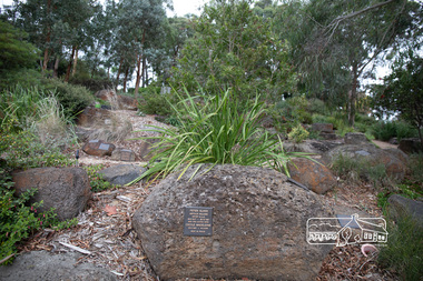
Negative - Photograph, Harry Gilham, Grave of Harriet Agrita Falkiner (1849-1923) , Eltham Cemetery, Victoria, Sep 2009
Harriet Falkiner was the daughter of Frederick Edward and Fanny Falkiner. Frederick was Eltham's first postmaster and settled in the district on the Diamond Creek and Yarra River around 1848 where he established an orchard and grazed cattle. The original family home was a pioneer settler's cottage built by Frederick Falkiner in Ely street.Roll of 35mm colour negative film, 6 stripsKodak GC 400-9alexander richard falkiner, eltham cemetery, evelyn falkiner, frederick edward falkiner, gravestones, harriet agrita falkiner -
 Eltham District Historical Society Inc
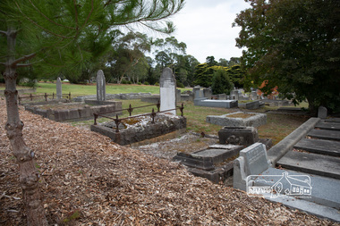
Negative - Photograph, Harry Gilham, Orford family graves, Eltham Cemetery, Victoria, Sep 2009
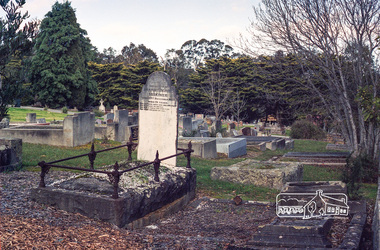
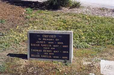
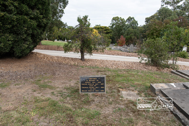
One of Eltham's earliest settlers was James Orford. Born 1804 in Bedfordshire, the son of George, a carpenter and Lydia Barret, he and wife Sarah Amelia nee Moull (1807) arrived as Assisted Immigrants aboard the ship, ‘Orestes’, November 28, 1839 accompanied by their children, George (14), Mary Ann (11), and James (2). Originally settling in New South Wales, daughter Sarah Amelia was born at Braidwood in 1843 and son, Thomas Henry at Pambula in 1847. James was a carpenter who is known to have built the original gates to Eltham Cemetery. He died in 1869. Around 1890, his son Thomas Henry Orford was living in Pitt Street. Following the death of his wife Helen in 1899, Thomas was appointed by Joseph Panton to look after ‘Panton Park’, a 429-acre bushland property at the fork of Reynolds and Laughing Waters Roads, extending down to the Yarra River. His work entailed ringbarking the manna gums on the property to clear the land for pasture. Thomas lived in a slab hut with his son Ernie, who helped with the work. When Gordon Lyon purchased Panton Park in 1908, Thomas then worked for Lyon at both Panton Park and at ‘Banyule’, Lyon's stud farm at Heidelberg. In 1915 Lyon gave Thomas six acres of land in Reynolds Road with a two-roomed cottage. Thomas died in 1944 and is buried in Eltham Cemetery with his wife and his parents. Another of James Orford's sons was James Matthias Orford. He tried to grow food on land at the end of Laughing Waters Road, but without success. Reputedly the Wurundjeri taught him to swim. He was once imprisoned; when his friend Constable Lawlor invited him to inspect the new bluestone lock-up, Lawlor locked him in and wouldn't release him until he was promised two gallons of beer! ORFORD In Memory Of James 1804 -1869 Sarah Amelia 1807 - 1897 Their son Thomas Henry 1847 - 1944 His wife Helen Amelia 1854 - 1899Roll of 35mm colour negative film, 6 stripsKodak GC 400-9eltham cemetery, gravestones, helen amelia orford, james orford, sarah amelia orford, thomas henry orford, cemetery gates -
 Eltham District Historical Society Inc
Photograph, Peter Pidgeon, Orford family graves, Eltham Cemetery, Victoria, 5 April 2021
One of Eltham's earliest settlers was James Orford. Born 1804 in Bedfordshire, the son of George, a carpenter and Lydia Barret, he and wife Sarah Amelia nee Moull (1807) arrived as Assisted Immigrants aboard the ship, ‘Orestes’, November 28, 1839 accompanied by their children, George (14), Mary Ann (11), and James (2). Originally settling in New South Wales, daughter Sarah Amelia was born at Braidwood in 1843 and son, Thomas Henry at Pambula in 1847. James was a carpenter who is known to have built the original gates to Eltham Cemetery. He died in 1869. Around 1890, his son Thomas Henry Orford was living in Pitt Street. Following the death of his wife Helen in 1899, Thomas was appointed by Joseph Panton to look after ‘Panton Park’, a 429-acre bushland property at the fork of Reynolds and Laughing Waters Roads, extending down to the Yarra River. His work entailed ringbarking the manna gums on the property to clear the land for pasture. Thomas lived in a slab hut with his son Ernie, who helped with the work. When Gordon Lyon purchased Panton Park in 1908, Thomas then worked for Lyon at both Panton Park and at ‘Banyule’, Lyon's stud farm at Heidelberg. In 1915 Lyon gave Thomas six acres of land in Reynolds Road with a two-roomed cottage. Thomas died in 1944 and is buried in Eltham Cemetery with his wife and his parents. Another of James Orford's sons was James Matthias Orford. He tried to grow food on land at the end of Laughing Waters Road, but without success. Reputedly the Wurundjeri taught him to swim. He was once imprisoned; when his friend Constable Lawlor invited him to inspect the new bluestone lock-up, Lawlor locked him in and wouldn't release him until he was promised two gallons of beer! ORFORD In Memory Of James 1804 -1869 Sarah Amelia 1807 - 1897 Their son Thomas Henry 1847 - 1944 His wife Helen Amelia 1854 - 1899Born Digitaleltham cemetery, gravestones, helen amelia orford, james orford, sarah amelia orford, thomas henry orford -
 Eltham District Historical Society Inc
Photograph, Peter Pidgeon, Memorial to Peter Glass and Cecile Glass, Eltham Cemetery, Victoria, 5 April 2021
In 1938, Arthur William Glass (known as Peter Glass) was studying painting under Max Meldrum. Much of their inspiration came from the Eltham bush and the nearby Yarra River. With his friends jazz musicians Graeme and Roger Bell, Peter bought land at the top of John Street: enchanted by Montsalvat, he had the objective of building a mud-brick house. War intervened, but then in 1948 he began working for Alistair Knox as a carpenter and mud-brick builder. By then, Peter had married, necessitating a larger house, which he built with help from Alistair Knox. As a trained architectural draftsman, Peter later progressed to working for Alistair in that role, eventually running the drafting office during the 1960s. He was deeply involved in the foundation of the Australian Institute of Landscape Architects, and went on to design many gardens, some in partnership with Alistair Knox and Gordon Ford. He died in 1997 and is buried in Eltham Cemetery with his wife Cecile. Peter Glass (Arthur William) Artist A.I.L.A. 28.8.1917 - 28.12.1997 and his loving wife Cecile Madeleine 23.2.1927 - 6.2.2006 Rest In PeaceBorn Digitaleltham cemetery, gravestones, heritage excursion, cecile madeleine glass, peter glass -
 Eltham District Historical Society Inc
Photograph, Peter Pidgeon, Grave of Harriet Agrita Falkiner (1849-1923) , Eltham Cemetery, Victoria, 5 April 2021
Harriet Falkiner was the daughter of Frederick Edward and Fanny Falkiner. Frederick was Eltham's first postmaster and settled in the district on the Diamond Creek and Yarra River around 1848 where he established an orchard and grazed cattle. The original family home was a pioneer settler's cottage built by Frederick Falkiner in Ely street.Born Digitaleltham cemetery, gravestones, heritage excursion, alexander richard falkiner, evelyn falkiner, frederick edward falkiner, harriet agrita falkiner -
 Eltham District Historical Society Inc
Photograph - Digital Photograph, Jim Connor, Boomerang House, 195 Laughing Waters Road, Eltham, 7 September 2013
Laughing Waters Walk, 7 Sep 2013 This Society excursion was a follow up to the Laughing Waters Story told to us by Jane Woollard at our Annual General Meeting in March 2013. It involved a walk commencing from the corner of Laughing Waters and Overbank Roads along Laughing Waters Road to its eastern end and returning partly over the same route - a total distance of about 2.5km. On the way we visited the two artist in residence properties, River Bend and Birrarung, to view the houses on them that are associated with Alistair Knox, Gordon Ford and others in the local mud brick and artistic community. We also able to walk around the derelict ruin which was once home to Gordon and Sue Ford, Boomerang House. An unexpected afternoon tea was offered to us by the artists in residence at Birrarung House and we had a brief opportunity to view inside the house. Gordon Ford and photographer Sue Winslow were married in 1965. They set up home in an old log cabin on the property Gordon had purchased in 1954 on Laughing Waters Road. Situated between the Yarra River and Overbank Road, Gordon had built a small mud-brick shack on the river and a pontoon. Over the decades the shack has been locally referred to as “the love shack”, the “rooting shack” or simply “Gordon’s shack”. Gordon and Sue commissioned local builder Graeme Rose to do a wattle and daub renovation and extension to the old log cabin on the north side of Laughing Waters Road. The work had only just been completed in 1965 when a bushfire swept through the area and destroyed the cabin. Gordon and Sue relocated to his property, Fulling, in Pitt Street, Eltham. In 1970 work started on a new house at the Laughing Waters property. Originally known as the Banana House, it is now known as Boomerang. Designed by Alistair Knox, the mud-brick house includes iron window grilles made by Matcham Skipper that puncture the curved mud walls. The grilles were made from ‘off-pressings’ from the Sidchrome tool works in Heidelberg. Gordon, Sue and family moved into the house in 1972. Their marriage fell apart and Sue moved to Sydney with the children around the same time Gordon commenced building Birrarung just below Boomerang on the Laughing Waters Road block. After the Fords moved out, Boomerang it was rented out to various share households of students, musicians, artists and environmentalists for twenty-four years. Gordon Ford sold Birrarung and Boomerang to Melbourne Water in 1999. The Laughing Waters Artist in Residence Program was developed as a partnership between Parks Victoria and Nillumbik Shire Council. Boomerang was deemed unfit for habitation so was used as a day studio only. By 2001 Boomerang was in a poor state of repair and by 2002 the last artist in residence was to use the house as a studio. Nillumbik Shire Council had been granted funds from the Melbourne Community Fund to restore both Boomerang and Birrarung but it was apparent in early 2003 that the funds would be insufficient to restore both houses. Boomerang was infested with termites which presented a risk to any occupants and so the decision was made to close Boomerang and concentrate funding on Birrarung. Boomerang was fenced off for safety and to prevent intrusion and remains ‘caged’ today (2023). However, it is readily apparent the property has been occupied by squatters over the years. By 2023 it was clear that the squatters had abandoned the property and sections of the roof structure have given away in some areas and collapsed internally. For a more in-depth description and history of the property and that of Gordon and Sue Ford, see Jane Woollard's book, "Laughing Waters Road; Art, Landscape & Memory in Eltham" published 2016.2013-09-07, activities, eltham district historical society, heritage excursion, jim connor collection, laughing waters road, boomerang house, gordon ford -
 Eltham District Historical Society Inc
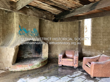
Photograph - Digital Photograph, Jim Connor, Fireplace, Boomerang House, 195 Laughing Waters Road, Eltham, 31 August 2021
Gordon Ford and photographer Sue Winslow were married in 1965. They set up home in an old log cabin on the property Gordon had purchased in 1954 on Laughing Waters Road. Situated between the Yarra River and Overbank Road, Gordon had built a small mud-brick shack on the river and a pontoon. Over the decades the shack has been locally referred to as “the love shack”, the “rooting shack” or simply “Gordon’s shack”. Gordon and Sue commissioned local builder Graeme Rose to do a wattle and daub renovation and extension to the old log cabin on the north side of Laughing Waters Road. The work had only just been completed in 1965 when a bushfire swept through the area and destroyed the cabin. Gordon and Sue relocated to his property, Fulling, in Pitt Street, Eltham. In 1970 work started on a new house at the Laughing Waters property. Originally known as the Banana House, it is now known as Boomerang. Designed by Alistair Knox, the mud-brick house includes iron window grilles made by Matcham Skipper that puncture the curved mud walls. The grilles were made from ‘off-pressings’ from the Sidchrome tool works in Heidelberg. Gordon, Sue and family moved into the house in 1972. Their marriage fell apart and Sue moved to Sydney with the children around the same time Gordon commenced building Birrarung just below Boomerang on the Laughing Waters Road block. After the Fords moved out, Boomerang it was rented out to various share households of students, musicians, artists and environmentalists for twenty-four years. Gordon Ford sold Birrarung and Boomerang to Melbourne Water in 1999. The Laughing Waters Artist in Residence Program was developed as a partnership between Parks Victoria and Nillumbik Shire Council. Boomerang was deemed unfit for habitation so was used as a day studio only. By 2001 Boomerang was in a poor state of repair and by 2002 the last artist in residence was to use the house as a studio. Nillumbik Shire Council had been granted funds from the Melbourne Community Fund to restore both Boomerang and Birrarung but it was apparent in early 2003 that the funds would be insufficient to restore both houses. Boomerang was infested with termites which presented a risk to any occupants and so the decision was made to close Boomerang and concentrate funding on Birrarung. Boomerang was fenced off for safety and to prevent intrusion and remains ‘caged’ today (2023). However, it is readily apparent the property has been occupied by squatters over the years. By 2023 it was clear that the squatters had abandoned the property and sections of the roof structure have given away in some areas and collapsed internally. For a more in-depth description and history of the property and that of Gordon and Sue Ford, see Jane Woollard's book, "Laughing Waters Road; Art, Landscape & Memory in Eltham" published 2016.jim connor collection, laughing waters road, boomerang house, gordon ford -
 Eltham District Historical Society Inc
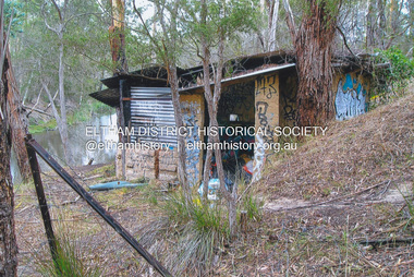
Photograph - Digital Photograph, Jim Connor, The Love Shack, 195 Laughing Waters Road, Eltham, 7 September 2013
Laughing Waters Walk, 7 Sep 2013 This Society excursion was a follow up to the Laughing Waters Story told to us by Jane Woollard at our Annual General Meeting in March 2013. It involved a walk commencing from the corner of Laughing Waters and Overbank Roads along Laughing Waters Road to its eastern end and returning partly over the same route - a total distance of about 2.5km. On the way we visited the two artist in residence properties, River Bend and Birrarung, to view the houses on them that are associated with Alistair Knox, Gordon Ford and others in the local mud brick and artistic community. We also able to walk around the derelict ruin which was once home to Gordon and Sue Ford, Boomerang House. An unexpected afternoon tea was offered to us by the artists in residence at Birrarung House and we had a brief opportunity to view inside the house. Gordon Ford and photographer Sue Winslow were married in 1965. They set up home in an old log cabin on the property Gordon had purchased in 1954 on Laughing Waters Road. Situated between the Yarra River and Overbank Road, Gordon had built a small mud-brick shack on the river and a pontoon. Over the decades the shack has been locally referred to as “the love shack”, the “rooting shack” or simply “Gordon’s shack”. Gordon and Sue commissioned local builder Graeme Rose to do a wattle and daub renovation and extension to the old log cabin on the north side of Laughing Waters Road. The work had only just been completed in 1965 when a bushfire swept through the area and destroyed the cabin. Gordon and Sue relocated to his property, Fulling, in Pitt Street, Eltham. In 1970 work started on a new house at the Laughing Waters property. Originally known as the Banana House, it is now known as Boomerang. Designed by Alistair Knox, the mud-brick house includes iron window grilles made by Matcham Skipper that puncture the curved mud walls. The grilles were made from ‘off-pressings’ from the Sidchrome tool works in Heidelberg. Gordon, Sue and family moved into the house in 1972. Their marriage fell apart and Sue moved to Sydney with the children around the same time Gordon commenced building Birrarung just below Boomerang on the Laughing Waters Road block. After the Fords moved out, Boomerang it was rented out to various share households of students, musicians, artists and environmentalists for twenty-four years. Gordon Ford sold Birrarung and Boomerang to Melbourne Water in 1999. The Laughing Waters Artist in Residence Program was developed as a partnership between Parks Victoria and Nillumbik Shire Council. Boomerang was deemed unfit for habitation so was used as a day studio only. By 2001 Boomerang was in a poor state of repair and by 2002 the last artist in residence was to use the house as a studio. Nillumbik Shire Council had been granted funds from the Melbourne Community Fund to restore both Boomerang and Birrarung but it was apparent in early 2003 that the funds would be insufficient to restore both houses. Boomerang was infested with termites which presented a risk to any occupants and so the decision was made to close Boomerang and concentrate funding on Birrarung. Boomerang was fenced off for safety and to prevent intrusion and remains ‘caged’ today (2023). However, it is readily apparent the property has been occupied by squatters over the years. By 2023 it was clear that the squatters had abandoned the property and sections of the roof structure have given away in some areas and collapsed internally. For a more in-depth description and history of the property and that of Gordon and Sue Ford, see Jane Woollard's book, "Laughing Waters Road; Art, Landscape & Memory in Eltham" published 2016.2013-09-07, activities, eltham district historical society, heritage excursion, jim connor collection, laughing waters road, boomerang house, gordon ford, gordon's shack, love shack -
 Eltham District Historical Society Inc
Document - Folder, Medhurst family
Alan Partington's research into his mother's family the Medhursts and the Rustons, who were early settlers in the Greensborough district. Contents Newspaper article: "How early families linked up" Diamond Valley News, 28 February 1984, Describes Alan Partington's research into his mother's family the Medhursts and the Rustons. Newspaper clippings, A4 photocopies, etcalan partington, annie-may medhurst, william partington, david medhurst, peter ruston, plenty river flour mill, greensborough hotel, panton hill victoria, henry hurst, martha medhurst (nee ruston), gruyere victoria, main street greensborough, heidelberg news, jack medhurst, james medhurst -
 Eltham District Historical Society Inc
Photograph, Fay Bridge, The Love Shack, 195 Laughing Waters Road, Eltham, April 2016
Gordon Ford built this shack on the Yarra at Laughing Waters Road. Bernie Bragg used to live there for a period of time. Gordon Ford and photographer Sue Winslow were married in 1965. They set up home in an old log cabin on the property Gordon had purchased in 1954 on Laughing Waters Road. Situated between the Yarra River and Overbank Road, Gordon had built a small mud-brick shack on the river and a pontoon. Over the decades the shack has been locally referred to as “the love shack”, the “rooting shack” or simply “Gordon’s shack”. Gordon and Sue commissioned local builder Graeme Rose to do a wattle and daub renovation and extension to the old log cabin on the north side of Laughing Waters Road. The work had only just been completed in 1965 when a bushfire swept through the area and destroyed the cabin. Gordon and Sue relocated to his property, Fulling, in Pitt Street, Eltham. In 1970 work started on a new house at the Laughing Waters property. Originally known as the Banana House, it is now known as Boomerang. Designed by Alistair Knox, the mud-brick house includes iron window grilles made by Matcham Skipper that puncture the curved mud walls. The grilles were made from ‘off-pressings’ from the Sidchrome tool works in Heidelberg. Gordon, Sue and family moved into the house in 1972. Their marriage fell apart and Sue moved to Sydney with the children around the same time Gordon commenced building Birrarung just below Boomerang on the Laughing Waters Road block. After the Fords moved out, Boomerang it was rented out to various share households of students, musicians, artists and environmentalists for twenty-four years. Gordon Ford sold Birrarung and Boomerang to Melbourne Water in 1999. The Laughing Waters Artist in Residence Program was developed as a partnership between Parks Victoria and Nillumbik Shire Council. Boomerang was deemed unfit for habitation so was used as a day studio only. By 2001 Boomerang was in a poor state of repair and by 2002 the last artist in residence was to use the house as a studio. Nillumbik Shire Council had been granted funds from the Melbourne Community Fund to restore both Boomerang and Birrarung but it was apparent in early 2003 that the funds would be insufficient to restore both houses. Boomerang was infested with termites which presented a risk to any occupants and so the decision was made to close Boomerang and concentrate funding on Birrarung. Boomerang was fenced off for safety and to prevent intrusion and remains ‘caged’ today (2023). However, it is readily apparent the property has been occupied by squatters over the years. By 2023 it was clear that the squatters had abandoned the property and sections of the roof structure have given away in some areas and collapsed internally. For a more in-depth description and history of the property and that of Gordon and Sue Ford, see Jane Woollard's book, "Laughing Waters Road; Art, Landscape & Memory in Eltham" published 2016.fay bridge collection, 2016-04, bernie's hut, birrarung, gordon ford, gordon's shack, laughing waters road, love shack, yarra river -
 Eltham District Historical Society Inc
Photograph, Fay Bridge, The Love Shack, 195 Laughing Waters Road, Eltham, 22 July 2016
Gordon Ford built this shack on the Yarra at Laughing Waters Road. Bernie Bragg used to live there for a period of time. Gordon Ford and photographer Sue Winslow were married in 1965. They set up home in an old log cabin on the property Gordon had purchased in 1954 on Laughing Waters Road. Situated between the Yarra River and Overbank Road, Gordon had built a small mud-brick shack on the river and a pontoon. Over the decades the shack has been locally referred to as “the love shack”, the “rooting shack” or simply “Gordon’s shack”. Gordon and Sue commissioned local builder Graeme Rose to do a wattle and daub renovation and extension to the old log cabin on the north side of Laughing Waters Road. The work had only just been completed in 1965 when a bushfire swept through the area and destroyed the cabin. Gordon and Sue relocated to his property, Fulling, in Pitt Street, Eltham. In 1970 work started on a new house at the Laughing Waters property. Originally known as the Banana House, it is now known as Boomerang. Designed by Alistair Knox, the mud-brick house includes iron window grilles made by Matcham Skipper that puncture the curved mud walls. The grilles were made from ‘off-pressings’ from the Sidchrome tool works in Heidelberg. Gordon, Sue and family moved into the house in 1972. Their marriage fell apart and Sue moved to Sydney with the children around the same time Gordon commenced building Birrarung just below Boomerang on the Laughing Waters Road block. After the Fords moved out, Boomerang it was rented out to various share households of students, musicians, artists and environmentalists for twenty-four years. Gordon Ford sold Birrarung and Boomerang to Melbourne Water in 1999. The Laughing Waters Artist in Residence Program was developed as a partnership between Parks Victoria and Nillumbik Shire Council. Boomerang was deemed unfit for habitation so was used as a day studio only. By 2001 Boomerang was in a poor state of repair and by 2002 the last artist in residence was to use the house as a studio. Nillumbik Shire Council had been granted funds from the Melbourne Community Fund to restore both Boomerang and Birrarung but it was apparent in early 2003 that the funds would be insufficient to restore both houses. Boomerang was infested with termites which presented a risk to any occupants and so the decision was made to close Boomerang and concentrate funding on Birrarung. Boomerang was fenced off for safety and to prevent intrusion and remains ‘caged’ today (2023). However, it is readily apparent the property has been occupied by squatters over the years. By 2023 it was clear that the squatters had abandoned the property and sections of the roof structure have given away in some areas and collapsed internally. For a more in-depth description and history of the property and that of Gordon and Sue Ford, see Jane Woollard's book, "Laughing Waters Road; Art, Landscape & Memory in Eltham" published 2016.fay bridge collection, 2016-07-22, bernie's hut, birrarung, gordon ford, gordon's shack, laughing waters, laughing waters road, love shack, yarra river -
 Eltham District Historical Society Inc
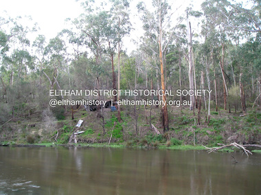
Postcard - Photograph postcard, The Rapids, Devils' Bank, Eltham, 1907
Devils' Bank was situated some two miles from Eltham. It is probably the section along the Yarra River where there are a series of rapids stretching past Petty's Orchard to Griffiths Park and the confluence with the Diamond Creek. Only three properties existed in this area in 1945 aerial maps, Worlingworth and the adjoining property on the bank of the Diamond Creek in Banoon Road and No. 2 Kent Hughes Road. Devils' Bank. The death of Ann Edwards, 77 years, an old resident of the district was reported who lived in an old hut at Devil's Bank who had been found dead in her bed on 13 May 1897 FOUND DEAD IN BED. (1897, May 28). Evelyn Observer, and South and East Bourke Record (Vic. : 1882 - 1902), p. 2 (MORNING.). Retrieved September 3, 2022, from http://nla.gov.au/nla.news-article60696388 A very similar view was published in the Leader paper in January 1908 - Devil's Bank Falls, Eltham VIEWS ON THE UPPER YARRA. (1908, January 11). Leader (Melbourne, Vic. : 1862 - 1918, 1935), p. 28. Retrieved September 3, 2022, from http://nla.gov.au/nla.news-article198106006 On the reverse of the postcard it appears to be postmarked Eltham, Dec 27, 1907 addressed to Mrs Christie Millmoss of Bull Street, Bendigo "Arrived here 10.45 am - ? ? raining cause of ? - ? till evenings it is lovely - but quite fresh after the (rain - crossed out) great ? - I may assume it all go well"Digital file only Postcards scanned from the collection of Michael Aitken on loan to EDHS, 2 Sep. 2022michael aitken collection, devils bank, eltham, postcards, rapids, yarra river -
 Eltham District Historical Society Inc
Document - Property Binder, 1045 Main Road, Eltham
Businesses, Eltham, Eltham Physiotherapy & Sports Injuries, Main Roadmain road, eltham, property, shops, businesses, russell yeoman, jim connor, eltham district historical society, plenty river, old eltham road, kangaroo ground, nillumbik council, barry rochford, main road eltham, luck street eltham, aladdin antiques montmorency, main road eltham roundabout, steven white, geoff glynn, michael murray, harold herd, enver camdal, helen bodycomb, rhonda noble, jeph neale, chris marks, john brumby, andrew haermeyer, sherryl garbutt, eltham shopping centre, eltham chamber of commerce and industry, norman williams, pat power, john graves, wattletree road eltham, bolton street eltham -
 Eltham District Historical Society Inc
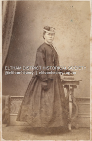
Photograph, Davies & Co, Believed to be Sarah Shillinglaw, c.1869
Sarah Shillinglaw was born at River Plenty on November 9, 1854. She married Charles Aldous on June 9, 1880 and died in Prahran, Victoria on August 3, 1925. Davies & Co (William Davies) operated from: 7 Bourke Street East 1867-1869 55 Bourke Street East 1874-1877 55 Bourke Street East as Central Photogrphic Studio (E. Sands Mgr) 1878-1884 73 Bourke Street East 1877 91 Bourke Street East 1864-1868 94 Bourke Street East 1864-1877 98 Bourke Street East 1860-1861 19 Collins Street East 1865-1868 5 Collins Street West 1866-1870 CARTE-DE-VISITE (cdv) 1857-1890 Cartes-de-visite (cdv's) are the most common form of photograph from the nineteenth century, generally measuring two and a half inches by four and an eighth inches (6.3 x 10.5 cm) when mounted, sepia toned, mounted on a card which was generally printed with the photographer's name and address on the back or beneath the portrait. - Frost, Lenore; Dating Family Photos 1850-1920; Valiant Press Pty. Ltd., Berwick, Victoria 1991marg ball collection, 1867-1869, 1869, davies & co post office photographic studio 7 bourke st east melbourne, paletot jacket, post office photographic studio, sarah aldous (nee shillinglaw 1854-1925), shillinglaw family photo album 2, unknown -
 Eltham District Historical Society Inc
Album - Photograph Album, J.A. McDonald, Bridge and Road Reconstruction Works, Shire of Eltham, 1952-1962
J.A. McDonald produced this record in the course of his responsibilities as Shire Engineer for Eltham Shire Council.Record of various Shire of Eltham infrastructure works undertaken during the period of 1952-1962 involving bridge and road reconstruction projects, sometimes with Eltham Shire Council Project Reference numbers quoted. It was during this period that a number of significant improvements were made to roads and new bridges constructed within the shire that remain in place as of present day (2022). In many situations, the photos provide a tangible visible record of infrastructure that existed throughout the early days of the Shire. The album was put together by or under the direction of the Shire Engineer, J.A. McDonald.a. gillies, alistair knox park, benchmark studies, bend of islands, blease road, box hill state school, box hill teachers college, box hill tip, bridge construction, bridge street bridge, bridge, brisbane street, brougham steet, bulldozer, cecil street, charis pelling, cherry tree road, city of preston, cr. a. brinkkotter, cr. charis pelling, cranes, cromwell street, diamond creek (creek), diamond street, dixons creek bridge, dixon's creek road, drott, eltham leisure centre, eltham north, eltham police station, eltham, eltham-yarra glen road, f. wood, fitzsimons lane bridge, flat rock road, flood damage, floods, floodwater, footpaths and gutters, ford service garage, g. blair, garden hill, glen park bridge, glenauburn road, grand hotel, haldane road, healesville, healesville-yarra glen road, heidelberg-kinglake road, henley road bridge, henley road, hill property, hurstbridge water scheme, hurstbridge, hurstbridge-arthurs creek road, infrastructure, j. jolly, kangaroo ground, kangaroo ground-queenstown road, kangaroo ground-st andrews road, lilydale shire office, long gully bridge, long gully creek, long gully road, long gully, lower plenty bridge, lower plenty footbridge, lower plenty oval, lower plenty road, lower plenty, main road, methodist church, montmorency, mount pleasant road, new holland, old healesville road, opening ceremony, oxley bridge, para road, paul creek bridge, paul creek road, paul krafeznk, pinnacle lane, plaques, plenty river trail, plenty river, presbyterian church, prof donald thomson, pryor street, railway crossing, railway parade, rattray road, reconstruction works, reichelt avenue, research (vic.), research oval, road construction, rymers corner, shire of eltham, shire of whittlesea, silvan road bridge, silver street bridge, silver street, sir dallas brooks, smedley property, st andrews, steels creek, susan street, tarrawarra, tony carberry, uniting church, upper yarra dam, upper yarra reservoir, w.e. wolf, waterfall property, watsons creek, wattletree road bridge, wattletree road, wattletree road bridge, worlingworth, yarra glen, york street, yow yow creek -
 Eltham District Historical Society Inc
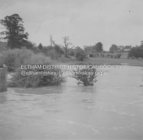
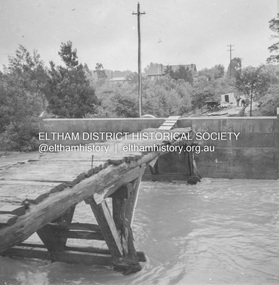
Album - Photograph, J.A. McDonald, Eltham-Greensborough Road, 18 Oct. 1956
Bridge Street Bridge Flooding on Hill’s property 18th October 1956 This view is looking west north west from the Bridge Street Bridge across the present day Eltham Skatepark. The shed visibile in the distance is directly opposite Brisbane Street where it used to run into Susan Street but now turns the corner. To the right of the shes is the site for present-dayHarris Plumbing which was formerly occupied by Sibbel Builders; to the left the site now occupied by Bunnings. At the skyline to the right of centreeline is a gap in the trees where the railway line runs. The Silver Street bridge over the railway is visible. Beware!.. our rivers are rising (1956, October 19). The Argus (Melbourne, Vic. : 1848 - 1957), p. 1. Retrieved August 24, 2022, from http://nla.gov.au/nla.news-article84392304Record of various Shire of Eltham infrastructure works undertaken during the period of 1952-1962 involving bridge and road reconstruction projects, sometimes with Eltham Shire Council Project Reference numbers quoted. It was during this period that a number of significant improvements were made to roads and new bridges constructed within the shire that remain in place as of present day (2022). In many situations, the photos provide a tangible visible record of infrastructure that existed throughout the early days of the Shire. The album was put together by or under the direction of the Shire Engineer, J.A. McDonald.infrastructure, road construction, shire of eltham, bridge construction, bridge street bridge, eltham, eltham-greensborough road, 1956-10-18, diamond creek (creek), floods, floodwater, hill property, silver street bridge -
 Eltham District Historical Society Inc
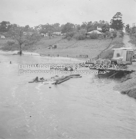
Album - Photograph, J.A. McDonald, Eltham-Greensborough Road, 18 Oct. 1956
Bridge Street Bridge Flood level on Greensborough pier 18th October 1956 View looking west across the Diamond Creek and tempoary walking access bridge towards intersection of Susan Street. The building visible on centreeline is the present-day SES facility. Beware!.. our rivers are rising (1956, October 19). The Argus (Melbourne, Vic. : 1848 - 1957), p. 1. Retrieved August 24, 2022, from http://nla.gov.au/nla.news-article84392304Record of various Shire of Eltham infrastructure works undertaken during the period of 1952-1962 involving bridge and road reconstruction projects, sometimes with Eltham Shire Council Project Reference numbers quoted. It was during this period that a number of significant improvements were made to roads and new bridges constructed within the shire that remain in place as of present day (2022). In many situations, the photos provide a tangible visible record of infrastructure that existed throughout the early days of the Shire. The album was put together by or under the direction of the Shire Engineer, J.A. McDonald.infrastructure, road construction, shire of eltham, bridge construction, bridge street bridge, eltham, eltham-greensborough road, 1956-10-18, diamond creek (creek), floods, floodwater, silver street bridge -
 Eltham District Historical Society Inc
Album - Photograph, J.A. McDonald, Eltham-Greensborough Road, 18 Oct. 1956
Bridge Street Bridge Flooding on Waterfall’s Estate 18th October 1956 Looking east up to Main Road over what is now present-day Alistair Knox Park Beware!.. our rivers are rising (1956, October 19). The Argus (Melbourne, Vic. : 1848 - 1957), p. 1. Retrieved August 24, 2022, from http://nla.gov.au/nla.news-article84392304Record of various Shire of Eltham infrastructure works undertaken during the period of 1952-1962 involving bridge and road reconstruction projects, sometimes with Eltham Shire Council Project Reference numbers quoted. It was during this period that a number of significant improvements were made to roads and new bridges constructed within the shire that remain in place as of present day (2022). In many situations, the photos provide a tangible visible record of infrastructure that existed throughout the early days of the Shire. The album was put together by or under the direction of the Shire Engineer, J.A. McDonald.infrastructure, road construction, shire of eltham, bridge construction, bridge street bridge, eltham, eltham-greensborough road, 1956-10-18, diamond creek (creek), floods, floodwater, silver street bridge, alistair knox park, waterfall property -
 Eltham District Historical Society Inc
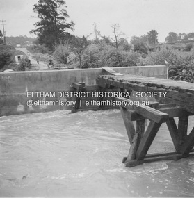
Album - Photograph, J.A. McDonald, Eltham-Greensborough Road, 18 Oct. 1956
... Street intersection Beware!.. our rivers are rising (1956... Street intersection Beware!.. our rivers are rising (1956 ...Bridge Street Bridge Flood level on Eltham pier 18th October 1956 Looking west across the Diamond Creek to Susan Street intersection Beware!.. our rivers are rising (1956, October 19). The Argus (Melbourne, Vic. : 1848 - 1957), p. 1. Retrieved August 24, 2022, from http://nla.gov.au/nla.news-article84392304Record of various Shire of Eltham infrastructure works undertaken during the period of 1952-1962 involving bridge and road reconstruction projects, sometimes with Eltham Shire Council Project Reference numbers quoted. It was during this period that a number of significant improvements were made to roads and new bridges constructed within the shire that remain in place as of present day (2022). In many situations, the photos provide a tangible visible record of infrastructure that existed throughout the early days of the Shire. The album was put together by or under the direction of the Shire Engineer, J.A. McDonald.infrastructure, road construction, shire of eltham, bridge construction, bridge street bridge, eltham, eltham-greensborough road, 1956-10-18, diamond creek (creek), floods, floodwater, silver street bridge -
 Eltham District Historical Society Inc
Document - Folder, McLean, 1984-1999
References to McLean family, Hector John McLean and Louisa Frances (nee Green) and six daughters who lived in Eltham during the period 1930 to 1934 inclusive. Lived in the former Evelyn Hotel at the time it was destroyed by fire and being part of the Centenary Parade in 1934 where the family won the Group Section for their entry “Pioneers of Eltham” Reminiscences provided by Edith Jones (nee M1934 flood, ballroom, baptism, barber shop, bittern, boy scouts, bremner's flat, burgoyne's shop, cable tram, cemetery road, centenary celebrations, centenary parade, christening, coach house, collis grocery, dalton street, depression, dole, dorothy jean mclean, edith jones (nee mclean), eltham fire brigade, eltham high school, eltham higher elementary school, eltham lower park, eltham railway station, eltham state school no. 209, evelyn hotel, fire damage - buildings, flinders naval depot, fordham, gladys evelyn mclean, gold mining, gwenneth mae mclean, gwladys evelyn mclean, headmistress, hector john mclean, isherwood house and shop, louisa frances mclean (nee green), metery road, methodist church, miss finnin, miss grant cottage, motor bike races, mrs barrett, mrs bremner, mrs hurley, olive isabel mclean, parade, phoebe lillian mclean, picnic, pioneers of eltham, pitt street, research fire brigade, rev. r.g. arthur, shed, shops, st margarets church hall, st margaret's church, stables, state savings bank of victoria, susso books, todaro, vinnie willet, warrandyte bridge, warrandyte, wingrove park, yarra river -
 Eltham District Historical Society Inc
Book, D. Pendavingh, Yarra River Trail Plan 1989: Banksia Street to Warrandyte, 1989
Also contains a loose A3 mylar plan inserted - Depart of Planning and Urban Growth, Heidelberg; Main Yarra Trail; Warringal Parklands and Banyule Flats, Detail Plan and Locality Plan