Showing 110289 items matching "roads"
-
 Phillip Island and District Historical Society Inc.
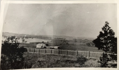
Photograph - Post Card, 1919
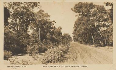
Donated by Stan McFee from the Keith McIlwraith Collection.Black & White Postcard of an unmade road to the Back Beach, Cowes. Road edged with trees and bushes."The Rose Series, P. 662" "Road to the Back Beach, Cowes, Phillip Is., Victoria". On Back: "This road 1 mile from Cowes" Letter: "Dear Marie, Wishing you many happy returns and the best of good wishes with much love. From all at "Heath Hill".road to back beach, cowes, phillip island, stan mcfee, keith mcilwraith collection -
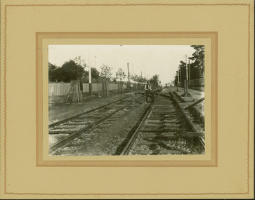
 Kew Historical Society Inc
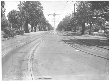
Photograph - Construction of the electric tram line in Riversdale Road, Camberwell, E.J. Dower, 1916
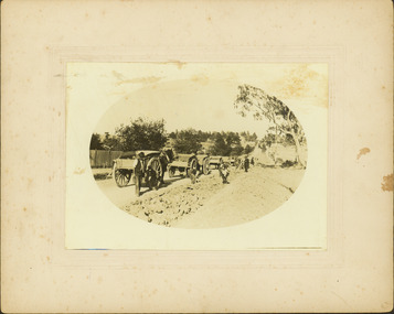
One of a series of photographs, taken by Edgar James Dower in the second decade of the twentieth century. Born and raised in Olinda, his family later moved to Surrey Hills. He worked as an adult as a clerk in the city office of the Metropolitan Gas Company, and in his role as a 'collector', he was able to photograph scenes including the construction of tramlines and associated buildings in Kew, Hawthorn, Camberwell and Surrey Hills. Later he established a real estate agency with his brother - the E.J. Dower Real Estate Agency, Dandenong Office.The image is an historically significant record of the development of transport infrastructure which was used to connect Victorians in the first two decades of the twentieth century. This development resulted from increases in population and the consequent extension of Melbourne's suburbs. The photographs, both individually and collectively, richly detail the labour of workers and the tools and machinery used to create and extend Melbourne's tram network in the years preceding and during World War 1.Digital copy of an original oval mounted photograph depicting preparation for laying the tracks for the new electric tramline in Riversdale Road, Camberwell. Annotated verso: "Riversdale Road / Preparing for electric tram line / Taken from near corner of Coolangatta Road"theme --- travelling by tram, theme -- connecting victorians by transport and communications, riversdale road -- camberwell, trams -- camberwell -
 Phillip Island and District Historical Society Inc.
Photograph, Unknown
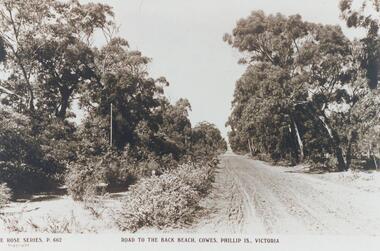
One of 16 photographs and postcards donated by Mary KarneyBlack & White postcard of a road to the Back Beach, Cowes."The Rose Series, P 662." "Road to the Back Beach, Cowes, Phillip Is., Victoria"dirt road, road to back beach cowes, phillip island, mary karney -
 Glenelg Shire Council Cultural Collection
Photograph - Photograph - grader at work, n.d
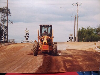
... roads ...Glenelg Shire Council records.Grader working on new road.construction, roads, civil engineering, grader, equipment -
 Kew Historical Society Inc
Photograph, Kilby Road, North Kew, 1916
Kilby Road, North Kew 1916. Annotation Reverse: "Kilby Road about 1916. Courtesy Mrs E. Bennett, Kew East."north kew, farming (kew), wade's farm (kew) -
 Kew Historical Society Inc
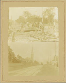
Photograph - Electric tram line construction in Cotham Road, Kew, E.J. Dower, 1913
One of a series of photographs, taken by Edgar James Dower in the second decade of the twentieth century. Born and raised in Olinda, his family later moved to Surrey Hills. He worked as an adult as a clerk in the city office of the Metropolitan Gas Company, and in his role as a 'collector', he was able to photograph scenes including the construction of tramlines and associated buildings in Kew, Hawthorn, Camberwell and Surrey Hills. Later he established a real estate agency with his brother - the E.J. Dower Real Estate Agency, Dandenong Office.The image is an historically significant record of the development of transport infrastructure which was used to connect Victorians in the first two decades of the twentieth century. This development resulted from increases in population and the consequent extension of Melbourne's suburbs. The photographs, both individually and collectively, richly detail the labour of workers and the tools and machinery used to create and extend Melbourne's tram network in the years preceding and during World War 1.Digital copy of two original mounted photographs depicting construction of a new electric tramline in Cotham Road, Kew. The upper photo shows workers standing among the newly laid tracks. The lower photo shows the vista of Cotham Road looking east towards the Kew Presbyterian Church on the corner of Highbury Road. Annotated verso: "Cotham Road Kew / Taken by E.J. Dower 1913"theme --- travelling by tram, theme -- connecting victorians by transport and communications, cotham road -- kew (vic.), trams -- kew (vic.) -
 City of Kingston
Photograph - Black and white, 1957
... Roads ...This image shows the increasing urbanisation of the formerly rural area of Moorabbin.Black and white photograph of the intersection of South Road and Chesterville Road, Moorabbin. A service station is visible on the left hand side, a truck is travelling along the road and shops are under construction on the right hand side.Handwritten in blue ink on reverse: 57-523B Handwritten in red ink on reverse: 100%moorabbin, shopping strip, paddocks, roads, cars -
 Ringwood and District Historical Society
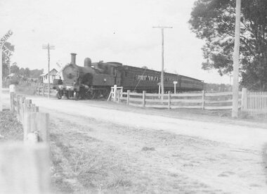
Photograph, Railway crossing, Bedford Road, Ringwood - c1925 2 copies, 1925
Steam train at Bedford Road railway crossing, Ringwood. Ferntree Gully line.Written above photograph, "Bedford Road railway crossing - c1925". -
 Ringwood and District Historical Society
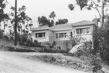
Photograph, No 12 Glenvale Road, North Ringwood. 1964, 1964
House in Glenvale Road (2 views). See also #2936-2939 for views of Glenvale Road taken at the same time.Written on back of photographs, "1964 - 12 Glenvale Road. Original supplied by Garrett Gundry." (2 views) -
 Kew Historical Society Inc
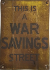
Sign, Commonwealth of Australia, This is a War Savings Street, 1939-1945
Elizabeth Nelson on eMelbourne has written that: "War Savings Streets were street-based savings groups that participated in the national war savings campaign during World War II. In May 1940 the Australian Government launched its Savings Certificates scheme which encouraged civilians to invest in the national war effort. Organisers of the savings campaign targeted Melbourne's suburbs individually with the aim of enlisting street savings groups. Each street group had a volunteer secretary who regularly sold war savings certificates to, and collected money from, other residents. The large number of war savings streets operating successfully in Melbourne made a significant contribution to the war effort."War Savings Street Street sign, presented to residents of Argyle Road, Kew (Vic) in 1942.Handwritten on reverse "Argyle Road Kew [Vic] 1942"second world war 1939-1945 - kew (vic), second world war 1939-1945 - fundraising, war savings street signs, ww2 -- savings certificates scheme -
 Kew Historical Society Inc
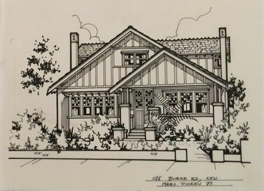
Drawing - Property Illustration, Margaret Picken, 1185 Burke Road, Kew, 1997
After training as a Cartographic Draftsman within the mining industry, I worked as a property illustrator for real estate firms in the eastern suburbs of Melbourne for 23 years from 1983. I initially photographed houses with a Polaroid camera and made a 'thumbnail' sketch while there. The photos were used to scale off a sketch in pencil and then that sketch was overlaid with drafting film and the 'pen and ink' completed. The pens I used were the Rotring ‘Rapidigraph’ drafting pens. The ink was also made by Rotring (German).The film was ‘Rapidraw’, polyester drafting film, double matte. It takes a very fine line and doesn’t bleed. As well as house sketches, there were often floor plans and site plans ordered. Aerial sketches were ordered when the property needed an overall view. (Margaret Picken, 2020)This drawing is one of a series created by Margaret Picken for a range of real estate agents in Melbourne between c.1983 and c.2005. Each work is signed and dated by the artist.Gift of Margaret Picken, 2020Pen and ink architectural drawing on drafting film of 1185 Burke Road, Kew by Margaret Picken.1185 BURKE ROAD., KEW / MARG PICKEN '97artist -- margaret picken 1950-, architectural drawings -- houses -- kew (vic.), 1185 burke road -- kew (vic.) -
 Hawthorn Historical Society
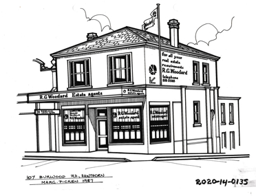
Drawing - Property Illustration, 107 Burwood Road, Hawthorn
'After training as a Cartographic Draftsman within the mining industry, I worked as a property illustrator for real estate firms in the eastern suburbs of Melbourne for 23 years from 1983. I initially photographed houses with a Polaroid camera and made a 'thumbnail' sketch while there. The photos were used to scale off a sketch in pencil and then that sketch was overlaid with drafting film and the 'pen and ink' completed. The pens I used were the Rotring ‘Rapidigraph’ drafting pens. The ink was also made by Rotring (German).The film was ‘Rapidraw’, polyester drafting film, double matte. It takes a very fine line and doesn’t bleed. As well as house sketches, there were often floor plans and site plans ordered. Aerial sketches were ordered when the property needed an overall view.' (Margaret Picken, 2020)This property illustration is one of a series created by Margaret Picken for a range of real estate agents in Melbourne between c. 1983 and c. 2006. Each work is signed and dated by the artist.Gift of Margaret Picken, 2020Pen and ink property illustration on drafting film of 107 Burwood Road, Hawthorn by Margaret Picken.107 Burwood Road, Hawthorn, Marg Picken '87. artist - margaret picken 1950- -
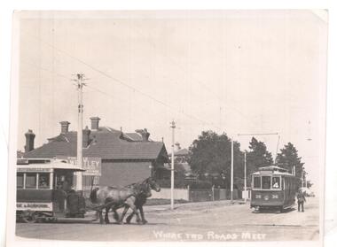 Ballarat Tramway Museum
Photograph - Black & White Photograph/s
Black & white photo ex Postcard? titled 'Where two roads meet', showing a horse tram ( Hawthorn Bridge to Auburn Road (Riversdale Road) and Prahran and Malvern No. 36 on Glenferrie Road with Deepdene destination, at the intersection of Riversdale & Glenferrie Roads, Hawthorn. Corner block (SE) behind photo has a 'For Sale' sign on it, with houses in background. Now a block of shops. Tram No. 36 is an F class car, later renumbered - see p14 of Destination City, 4th edition. See also inscriptions. Questions: How horse tram number determined and date of photograph??`` Reimaged 17/7/2017 both front and back.'T101, No. 26 horse tram of Hawthorn Tramway Trust in Riversdale Road. No. 36 toastrack (enclosed cross seat) of the Prahran & Malvern Trams in Glenferrie Road, Hawthorn 1917. Horse trams ran from Auburn Road to Hawthorn Bridge and connected with the Richmond cable trams. W.Jack.'trams, tramways, pmtt, horse trams, riversdale road, glenferrie rd , tram f 36 -
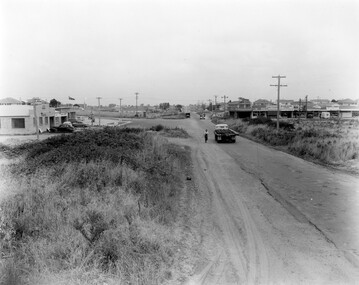
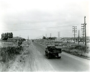 City of Kingston
Photograph - Black and white, c. 1957
... Roads ...This image shows the urbanisation of a formerly rural area of Moorabbin.Black and white photograph looking west along South Road. There is a truck in the foreground, travelling along the sealed South Road. A car is waiting to exit from Rowan Road. People are walking along the left hand side of the road, and a young person a bike is riding along the right side. They are all going in the same direction as the traffic. The left hand side of the image shows paddocks in the foreground, which houses further back. The right hand side of the image shows suburban houses with electricity poles running the length of the road. Handwritten in blue ink on reverse: 57-523A Handwritten in red ink on reverse: 85% Handwritten in black ink or grey lead: Ch. 6moorabbin, cars, roads, housing -
 Whitehorse Historical Society Inc.
Document, Motor Cycle Climb and mud bash|A Walk down memory lane|An early glimpse of Royton Street, 1994
Hartwell Motor Cycle Club.Hartwell Motor Cycle Club. The East Burwood section of its run comprised Holland road, Burwood Road and Ely Road. It was very steep and muddy. Description of a walk along Burwood Road to Middleborough Road in 1929 - 30. History of Royton Street, East Burwood and its neighbourhood from the 1930's to the present.Hartwell Motor Cycle Club. motor cycles, hartwell motor cycle club, holland road, burwood east, eley road, burwood east, burwood east state school no 454, royton street, burwood east, walford family, orchards, cooinda court, burwood east, market gardens, east burwood methodist church, french, joseph a, black, roy, rescheck family, french, harry w, crow, ernie, mclean, leckie, newbigin family, royton street, burwood east, no 30, hele family, french family, carrol family, tally ho post office, walford family -
Whitehorse Historical Society Inc.
Map, City of Nunawading, 1973
Map showing streets, plot numbers, schools, open space and land usage.Map showing streets, plot numbers, schools, open space and land usage. A project by A Gray, student at Vermont High School. Area covered from Canterbury Road to Burwood Road and Terrara Road to Morack Road. Scale: 800 ft: 1 inchMap showing streets, plot numbers, schools, open space and land usage.vermont south, vermont, vermont high school, parks and reserves -
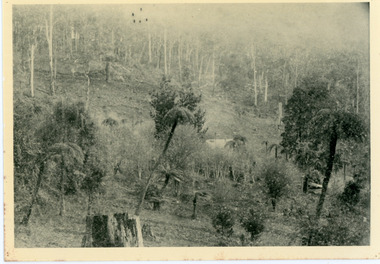 Mt Dandenong & District Historical Society Inc.
Photograph, Home of George Dodd at Olinda 1895, 1895
1895 picture of the home of George Dodd built c1880. Shows the Selector's Road made in the 1880s from Pig Lane in The Basin to the road in front of the Mt dandenong Hotel.The descriptive text on the reverse of this photograph was hand written by John Lundy-Clarke.1895 picture of the home of George Dodd built about 1880 showing the road the selectors made in the 1880s from Pig Lane to the main road in front of the present Mt Dandenong Hotel near the present end of the Basin-Olinda Road. It was never gazetted as a road as the Bruces objected to it and landslides in 1891 closed it temporarily and later landslides closed it permanently.george dodd, dodd, mt dandenong hotel, selector's road, road, pig lane -
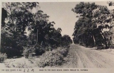 Phillip Island and District Historical Society Inc.
Photograph, Road to Back Beach, Cowes
Part of a collection of 'Rose & Valentine' series of Post Cards. Copied by John Jansson 1984Black & White Postcard. Road to the Back Beach, Phillip IslandThe Rose Series P662. Road to the Back Beach, Cowes, Phillip Island, Victorialocal history, photography, photographs, postcards, phillip island, black & white postcard copy., back beach -
 City of Kingston
Photograph - Black and white, c. 1963
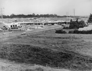
... Roads ...This image depicts the intersection of increasing urbanisation and the rural landscape that once made up the area now known as City of Kingston.Black and white photograph of the intersection of Warrigal Road and Centre Road, South Oakleigh, viewed from the reservoir. In the foreground are paddocks and in the background is a shopping strip, including a petrol station.Handwritten in blue ink on reverse: 2196 Handwritten in red ink on reverse: 100%oakleigh, roads, shopping strip, paddocks -
 Ringwood and District Historical Society
Newspaper, Scrapbook Clipping, Library Collection, Ringwood, Victoria
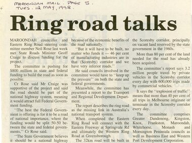
Newspaper Clipping from the ""Mail", 12 May 1998 P5. "Ring road talks"Maroondah councillor and Eastern Ring Road steering committee member Neil Rose last week met State Roads Minister Geoff Craige to discuss funding for the project. The committee is pushing for $800 million in state and federal funding to build the road as soon as possible. -
 Mt Dandenong & District Historical Society Inc.
Photograph, Devine family, Olinda, 1911
Mr Devine, Mrs Devine (nee Stewart) with children Vera and Stewart at their home 'Hillcrest' on Mernda Road (now Coonara road), Olinda 1911. The descriptive text on the reverse of this photograph was hand written by John Lundy-Clarke.Devine, Mrs Devine (nee Stewart) Vera Stewart 1911 on verandah of “Hillcrest” Mernda Road now Coonara Road. Mrs Dodd’s collection. Copied by J.L.C. 1974. vera devine, stewart devine, hillcrest, mernda road, coonara road, olinda, devine -
 Glen Eira Historical Society
Album - Album page, Glen Huntly Road, Circa 1972
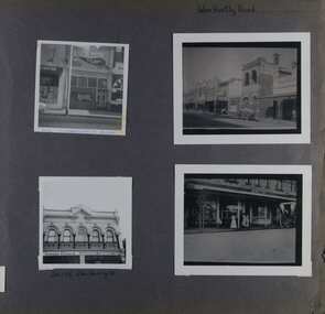
This photograph is part of the Caulfield Historical Album 1972. This album was created in approximately 1972 as part of a project by the Caulfield Historical Society to assist in identifying buildings worthy of preservation. The album is related to a Survey the Caulfield Historical Society developed in collaboration with the National Trust of Australia (Victoria) and Caulfield City Council to identify historic buildings within the City of Caulfield that warranted the protection of a National Trust Classification. Principal photographer thought to be Trevor Hart, member of Caulfield Historical Society. Most photographs were taken between 1966-1972 with a small number of photographs being older and from unknown sources. All photographs are black and white except where stated, with 386 photographs over 198 pages. 376 Glen Huntly Road is a contributory building to HO72 - Elsternwick Estate and Environs, City of Glen Eira.Page 64 of Photograph Album with four photographs of different properties on Glen Huntly Road - 2 in portrait mode and 2 in portrait photographs of photographs.Hand written: Glen Huntly Road [top right] / 376 GLENHUNTLY ROAD [written in blue pen on the bottom edge of the top left photo] / 216-218 Glen Huntly Rd [under bottom left photo] / 64 [bottom right] trevor hart, glen huntly road, elsternwick, shops, streetscapes, vintage cars, carriages and coaches, glenhuntly road -
 City of Kingston
Photograph - Black and white, c. 1950
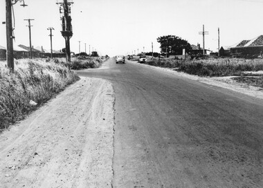
A car travelling along South Road Moorabbin, with the Tucker Road intersection on the left hand side. Houses are on either side of the road which also has wide shoulders and nature strips.A car travelling along a sealed road with wide shoulders and houses on either side of the road.Handwritten in red ink on reverse: 72% Handwritten in blue ink on reverse: 2192 [circle around all text, including red ink]transport, moorabbin, cars, houses -
 Melbourne Tram Museum
Photograph - Dandenong and Glenferrie Roads, c1950
Photo looking west shows the curve from Dandenong Road into Glenferrie Road. In the background is a shelter at the stop for the junction with Hawthorn Road. Shows the centre poles, the closest one being fitted with a section insulator with associated wiring and the trees along the central reservation. Photo c1950.Yields information about Dandenong Road at Glenferrie Road.Black and White photograph with note on the rear.In pencil "Dandenong & Glenferrie Roads"tramways, dandenong road, central poles, shelters -
 Melbourne Tram Museum
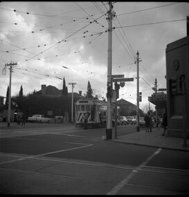
Photograph - Track cleaner No. 7 - Glenferrie Road and Malvern Road, Warren Doubleday, 31-7-1969
Photo shows Track cleaner No. 7 - Glenferrie Road and Malvern Road. On the right hand side is the Malvern Hotel.Yields information about the use of the track cleaner.Black and white photograph of Track cleaner No. 7 - Glenferrie Road and Malvern RoadHas details on rear in red ink.tramways, trams, track cleaner, tram 7, glenferrie road, malvern road -
 Ringwood and District Historical Society
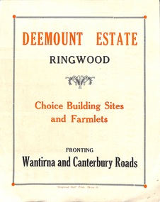
Flyer, Subdivisional Land Sale advertisement - Deemount Estate, Ringwood, Vic. - c.1950
Double sided folded page with black and orange advertisement and blueprint for Deemount Estate fronting Canterbury and Wantirna Roads, Ringwood, with handwritten price list and terms of sale. Additional undated hand-drawn map on light cardboard - 4 allotments on western side of Maidstone Street .Subdivision includes Canterbury Road, Wantirna Road and Maidstone Street. -
 St Kilda Historical Society
Photograph, 11 Eildon Road, St Kilda, 1990-2000?
oringinal colour photograph, TV aerial, cars parked in roadcolour photograph, unmounted good condition11 Eildon Road -
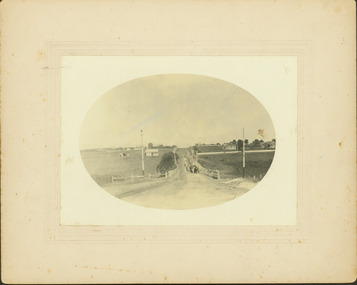 Kew Historical Society Inc
Photograph - Riversdale Road, Surrey Hills, E.J. Dower, c.1915
Contextual or historic information One of a series of photographs, taken by Edgar James Dower in the second decade of the twentieth century. Born and raised in Olinda, his family later moved to Surrey Hills. He worked as an adult as a clerk in the city office of the Metropolitan Gas Company, and in his role as a 'collector', he was able to photograph scenes including the construction of tramlines and associated buildings in Kew, Hawthorn, Camberwell and Surrey Hills. Later he established a real estate agency with his brother - the E.J. Dower Real Estate Agency, Dandenong Office.The image is an historically significant record of the development of transport infrastructure which was used to connect Victorians in the first two decades of the twentieth century. This development resulted from increases in population and the consequent extension of Melbourne's suburbs. The photographs, both individually and collectively, richly detail the labour of workers and the tools and machinery used to create and extend Melbourne's tram network in the years preceding and during World War 1.Digital copy of an original oval mounted photograph depicting Riversdale Road, Surrey Hills, before the construction of the proposed electric tramline.Annotated verso: "Riversdale Road Surrey Hills / Preparing for electric tram line / Note Essex Road on right with picket fencing."theme --- travelling by tram, theme -- connecting victorians by transport and communications, riversdale road -- surrey hills, tramlines -- surrey hills -
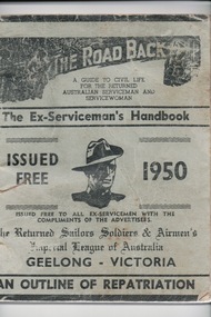 Lara RSL Sub Branch
Handbook, W.A.Cooney, The Road Back, 1947/1950
The handbook was distributed to all ex-servicemen on return from WW2 in the Geelong area and was a guide to civil life.This booklet for returned service personnel from World War 2 living in the Geelong Region is og local district significance as a part of the history of Geelong.The Road Back -two of The Ex-Serviceman's Handbooks,1947/ 1950 Geelong Issued Free.One is Light green in colour with black writingThe Road Back The Ex-Serviceman's Handbook Geelong.the road back, the ex-serviceman's handbook, world war 2, ww2, australian aif, australian serviceman, australian servicewoman, rss&aila, army, navy, air force, returned sailor's, soldier's and airmen's imperial league of australia, rsl -
 Kew Historical Society Inc
Photograph - Electric tram line construction in Cotham Road, Kew, E.J. Dower, 1913
One of a series of photographs, taken by Edgar James Dower in the second decade of the twentieth century. Born and raised in Olinda, his family later moved to Surrey Hills. He worked as an adult as a clerk in the city office of the Metropolitan Gas Company, and in his role as a 'collector', he was able to photograph scenes including the construction of tramlines and associated buildings in Kew, Hawthorn, Camberwell and Surrey Hills. Later he established a real estate agency with his brother - the E.J. Dower Real Estate Agency, Dandenong Office.The image is an historically significant record of the development of transport infrastructure which was used to connect Victorians in the first two decades of the twentieth century. This development resulted from increases in population and the consequent extension of Melbourne's suburbs. The photographs, both individually and collectively, richly detail the labour of workers and the tools and machinery used to create and extend Melbourne's tram network in the years preceding and during World War 1.Digital copy of an original mounted photograph depicting construction of a new electric tramline in Cotham Road, Kew. The photo shows a worker standing on the tracks at the then terminus.Annotated verso: "Preparing for electric trams / Cotham Road Kew / Taken from corner of Burke Road / 1913"theme --- travelling by tram, theme -- connecting victorians by transport and communications, cotham road -- kew (vic.), trams -- kew (vic.)