Showing 207225 items matching "royal-melbourne-institute-of-technology"
-
 Federation University Historical Collection
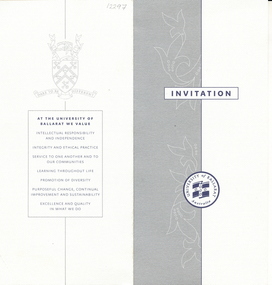
Document - Invitation, Occasional Address by Geoffrey Blainey to mark the University of Ballarat TAFE 140th anniversary and the 150th anniversary of the Ballarat Mechanics' Institute, 2010 (exact)
... University of Ballarat TAFE 140th anniversary and the 150th...University of Ballarat ...Geoffrey Blainey was the inaugural Chancellor of the University of Ballarat (later Federation University)White card invitation with the University of Ballarat logo on the front. The ivitation was to an occasional address by Geoffrey Blainey to mark the University of Ballarat TAFE 140th anniverary and the 150th anniversary of the Ballarat Mechanics' Institute. The address was held in the Humffray Room at the Ballarat Mechanics' Instituteuniversity of ballarat, david battersby, ballarat mechanics institute, geoffrey blainey, ballaarat mechanics' institute, 140th anniversary, anniversary -
 Slovenian Association Melbourne
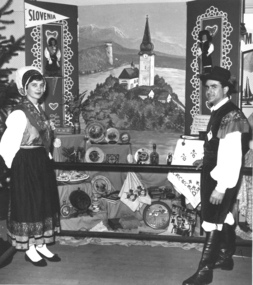
Slovenians at Royal Melbourne Show 1959, Slovenians in national costumes at the Royal melbourne Show in 1959, 1959
The Slovenians enjoyed participation at the Royal Melbourne Show 1959 where they could showcase the Slovenian traditions, arts and crafts, and at times,culinary goodies as well.Traditional Slovenian crafts, national costume and the tourism jewel Lake BledSlovenian couple dressed in Slovenian national costume of Gorenjska region at the Royal Melbourne Show in 1959. The painting shows the tourist attraction Lake Bled and many traditional items of craft were placed in the exhibition as well. The man in the photo is Leopold Jalk.Couple dressed in Slovenian national costume, painting of Lake Bled and Slovenian traditional craftsslovenian national costume, slovenian crafts, lake bled, royal melbourne show -
 Federation University Historical Collection
Photograph, Launch of the State Revenue Office on the Ballarat Technology Park
... Launch of the State Revenue Office on the Ballarat ...Launch of the State Revenue Office at the Ballarat Technology Park.state revenue office, ballarat technology park, irrr, begonia festival -
 National Wool Museum
Textile - Australian Open Sportwool Top, CSIRO Division of Textile and Fibre Technology, c. 2000s
... CSIRO Division of Textile and Fibre Technology ...Sportwool® was developed to combine the physical performance attributes of synthetics with the comfort and breathability of a natural fibre. It is a lightweight, composite fabric consisting of a layer of machine-washable superfine Merino wool next to the skin and a layer of tough, easy-care polyester on the outside. As a result of this construction: - the wearer feels cooler more quickly and formation of liquid sweat is delayed - liquid sweat is carried away from the skin to the outside of the fabric, leaving - the inside dry and resulting in less ‘clammy’ garment cling - the wearer stays cooler when exercising - ‘post-exercise chill’ is reduced. In addition, Sportwool® is elastic, provides UV protection and does not retain odours. Sportwool® is constructed in weights ranging from ultra-light for jogging, to thicker, heavy-duty fabric for football jerseys. It is easily printed in bright colours and designs, including information about sponsors and players. Sportwool® can also be dyed in solid colours. The development of Sportwool® was funded by The Woolmark Company (now Australian Wool Innovation Limited). Source: https://csiropedia.csiro.au/sportwool/9095.1 - Long sleeve blue sports top with with orange and navy striped detail. 9095.2 - Clothing label tag featuring a black silhouette of a tennis player, with organe and white text and orange and blue graphics on a black background. 9095.3 - Four page fold out clothing label tag, front features printed text, silhouette sports graphics and a background of an orange and blue landscape.9095.1 Australian Open / Sportwool / Sportwool 9095.2 - front: [printed] Australian Open / OFFICIAL / LICENSED / PRODUCT 9095.3 - front: [printed] SPORTWOOL / Vapour Management Technology / www.sportwool.comsportswool, australian open, athletes, clothing, the woolmark company, csiro division of textile and fibre technology, uniforms -
University of Melbourne, Burnley Campus Archives
Card - Bookmark, Study Horticulture, 2005
... Found in the Cottage, former residence of Poultry Curator ...open days, burnley campus, mcmillan campus -
 Federation University Historical Collection
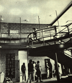
Photograph, The Knuckle at Gippsland Institute of Advanced Education, c1976
... The Knuckle at Gippsland Institute of Advanced Education ...The Gippsland Institute of Advanced Education was established by an Order-in-Council in September 1968. The Council of the Institute included members of the Gippsland community who are prominent in local government, industry, commerce, education and the professions, the Director of the Institute, and representatives of the academic staff, students, and graduates. On its establishment, the institute assumed responsibility for the diploma courses previously offered by the Yallourn Technical College which had commenced diploma teaching in 1929. Initially, all the Institute's teaching was conducted in the diploma building of the Yallourn Technical College. In 1972 the Institute transferred part of its operations to the first of its permanent buildings on a large campus in rural surrounds near the township of Churchill, ten kilometres south of MOrwell and one hundred and sixty kilometres east of Melbourne. The Gippsland Institute of Advanced Education was opened on 20 November 1976 by the Honourable Lindsay Thompson, Deputy Premier of Victoria and Minister of Education; and Senator J.L. Carrick, Minister for Education in the Commonwealth Government. Image of an area in the Gippsland Institute of Advanced Education known as The Knuckle.gippsland institute of advanced education, gippsland campus collection, the knuckle, churchill -
 Ballarat Heritage Services
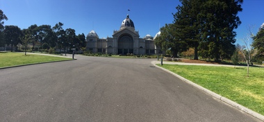
Photograph - Photograph - Colour, Clare Gervasoni, Royal Exhibition Building Melbourne, 2018, 10/2018
Panoramic photograph of the Royal Exhibition Building in Melbourne. royal exhibition building, architecture, carlton gardens -
 Federation University Historical Collection
Promotional Card, University of Ballarat School of Information Technology & Mathematical Sciences, 2005, 2005
... University of Ballarat School of Information Technology ...Federation University Australia was established on 1 January 2014. Formerly known as the University of Ballarat, its enabling legislation was the University of Ballarat Amendment (Federation University Australia) Act 2013. Although formally created as a University in 1994, the University of Ballarat has a lineage back to 1870 with the establishment of the School of Mines Ballarat, making it the third institution of higher learning to be established in Australia and the first to be established in regional Australia. On 1 January 1994, Ballarat University College became the University of Ballarat and in 1998 the University merged with three TAFE Institutes to become a dual sector institution with multiple campuses. On 1 January 2014, the University of Ballarat amalgamated with the Monash University Gippsland Campus to form Federation University Australia. The Gippsland Campus also had a long lineage dating back to 1928 with the establishment of the Yallourn Technical School which became a predecessor institution to the Gippsland College of Advanced Education formed in 1968. In 1990, it was renamed the Monash University College and in 1993 became the Gippsland Campus of Monash University. In 2016, Federation University Australia announced plans to take possession, over a two-year period, of Monash’s Berwick Campus in the south-east corridor of Melbourne. Federation University Australia, or FedUni, is headquartered in Ballarat and offers programs in Higher Education and Vocational Education and Training to regional Victoria and beyond. The University’s commitment to educational and social equity, teaching excellence, research distinction, environmental sustainability and regional capacity building has enabled it to develop in a way that draws on its proud heritage to inform its future. Its regional character sets a framework for the University’s priorities but does not constrain it from serving wider community interests, nationally and internationally. The name Federation University Australia was chosen to convey the scope and capacity of an expanded regional university with a federated network of campuses.A double sided card with four folds, making it around the size of a business card. The card gives information on Information Technology and Mathematical Sciences Content and images.university of ballarat, school of information technology and mathematical sciences, itms, promotional, marketing, computer games, earn as you learn, business systems, mathematics, information technology -
 Robin Boyd Foundation
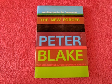
Book, Peter Blake, The New Forces, 1970
... Royal Australian Institute of Architects (Victoria) ...SoftcoverNewspaper article from Bulletin Review about Robin Boyd and the series "Melbourne Architectural Papers", of which this is one as well as Number 1918 and 1019pop architecture, 1970s' architecture, walsh st library -
 Federation University Historical Collection
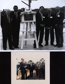
Photograph - colour, Turning the sod at the University of Ballarat Technology Park, 1989, 03/08/1989
... Turning the sod at the University of Ballarat Technology ...University of Ballarat is a predecessor institution of Federation University Australia. A number of people watch David White, Minister for Industry, Technology and Resources turn the first sod of Ballarat's Technology Park. Left to right: David White; John Sharpham (Director, Ballarat University College); John Beaumont (Director, Ballarat Technology Park); Stephen Elder M.L.A.; John Mildren M.H.R.ballarat technology park, southern region data centre, university of ballarat technology park, federation university technology park, david white, john sharpham, john beaumont, stephen elder, john mildren, turn the sod -
Vision Australia
Text, Australian Institute of Management - Victoria Certificate of Company Membership, 29 April 1994
... Australian Institute of Management - Victoria Certificate ...The certificate certifies that the Royal Victorian Institute for the Blind LTD has been admitted as a Company member of the Australian Institute of Management. Signed by the AIM Executive Director and President (illegible).1 x A3 paperSeal of the Australian Institute of Management attached to the bottom left hand cornerroyal victorian institute for the blind -
University of Melbourne, Burnley Campus Archives
Booklet (Item), The University of Melbourne, Burnley College Graduation Ceremony and Presentation of Awards, 1998 - 2004
... Burnley College Graduation Ceremony and Presentation of...The University of Melbourne ...Some marked Dr. Greg Moore or Dr. Peter Mayburnley college, institute of land and food resources, university of melbourne, greg moore, peter may, graduation ceremony -
 Victorian Aboriginal Corporation for Languages
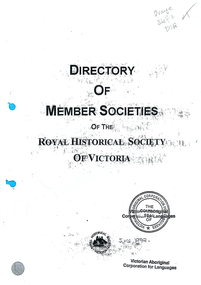
Book, Royal Historical Society of Victoria, Directory of Member Societies of the Royal Historical Society of Victoria, 1997
... Directory of Member Societies of the Royal Historical...Royal Historical Society of Victoria ...Listing of all Historical Societies in Victoria with data for each.royal historical society of victoria, historical directories -
Federation University Historical Collection
Booklet, School of Botany, University of Melbourne, The Families and Genera of Victorian Plants, February 1992
... The Families and Genera of Victorian Plants...School of Botany, University of Melbourne...School of Botany, University of Melbourne, Melbourne ...Spiral bound booklet with green card covers.botany, victorian flora, families, genera, taxonomy, plants, school of botany, university of melbourne, identification, plant identification, flora -
 Kew Historical Society Inc
Plan, Melbourne & Metropolitan Board of Works : Borough of Kew : Detail Plan No.1582, 1904
... Melbourne & Metropolitan Board of Works : Borough of Kew...Melbourne and Metropolitan Board of Works ...The Melbourne and Metropolitan Board of Works (MMBW) plans were produced from the 1890s to the 1950s. They were crucial to the design and development of Melbourne's sewerage and drainage system. The plans, at a scale of 40 feet to 1 inch (1:480), provide a detailed historical record of Melbourne streetscapes and environmental features. Each plan covers one or two street blocks (roughly six streets), showing details of buildings, including garden layouts and ownership boundaries, and features such as laneways, drains, bridges, parks, municipal boundaries and other prominent landmarks as they existed at the time each plan was produced. (Source: State Library of Victoria)This plan forms part of a large group of MMBW plans and maps that was donated to the Society by the Mr Poulter, City Engineer of the City of Kew in 1989. Within this collection, thirty-five hand-coloured plans, backed with linen, are of statewide significance as they include annotations that provide details of construction materials used in buildings in the first decade of the 20th century as well as additional information about land ownership and usage. The copies in the Public Record Office Victoria and the State Library of Victoria are monochrome versions which do not denote building materials so that the maps in this collection are invaluable and unique tools for researchers and heritage consultants. A number of the plans are not held in the collection of the State Library of Victoria so they have the additional attribute of rarity.Original survey plan, issued by the MMBW to a contractor with responsibility for constructing sewers in the area identified on the plan within the Borough of Kew. The plan was at some stage hand-coloured, possibly by the contractor, but more likely by officers working in the Engineering Department of the Borough and later Town, then City of Kew. The hand-coloured sections of buildings on the plan were used to denote masonry or brick constructions (pink), weatherboard constructions (yellow), and public buildings (grey). Public buildings, coloured grey on the Plan 1582 include the police station and post office, churches and schools. The earliest church school, Common School No.356 was located at the rear of the Congregational Church in Peel Street. It was constructed in 1859. The first buildings of Kew Primary School No.1075 on the other side of Peel Street were constructed in 1871. The school in 1903 only occupied a small fraction of its current site. In 1903, where the rear playground is now located, were two weatherboard and one brick villa. Trinity Grammar School was founded in 1902 and opened in the Parish Hall at the rear of Holy Trinity Anglican Church. It was not to move to its current site until 1906. The outline of the building housing the Kew Fire Brigade in the centre of the north side of Walton Street is shown but not named on the plan. Further down Pakington Street stood the two-storey Italianate mansion ‘Overton’. The home of Stanford Chapman, it was to be featured in the Imperial Institute series of bromide photographs of Victoria, Vol. 1: Homes and scenery. It was later to become a boarding house before it was later demolished.melbourne and metropolitan board of works, detail plans, maps - borough of kew, mmbw 1582, cartography -
 Kew Historical Society Inc
Plan, Melbourne & Metropolitan Board of Works : Borough of Kew : Detail Plan No.1590, 1905
... Melbourne & Metropolitan Board of Works : Borough of Kew...City of Kew...Melbourne and Metropolitan Board of Works ...The Melbourne and Metropolitan Board of Works (MMBW) plans were produced from the 1890s to the 1950s. They were crucial to the design and development of Melbourne's sewerage and drainage system. The plans, at a scale of 40 feet to 1 inch (1:480), provide a detailed historical record of Melbourne streetscapes and environmental features. Each plan covers one or two street blocks (roughly six streets), showing details of buildings, including garden layouts and ownership boundaries, and features such as laneways, drains, bridges, parks, municipal boundaries and other prominent landmarks as they existed at the time each plan was produced. (Source: State Library of Victoria)This plan forms part of a large group of MMBW plans and maps that was donated to the Society by the Mr Poulter, City Engineer of the City of Kew in 1989. Within this collection, thirty-five hand-coloured plans, backed with linen, are of statewide significance as they include annotations that provide details of construction materials used in buildings in the first decade of the 20th century as well as additional information about land ownership and usage. The copies in the Public Record Office Victoria and the State Library of Victoria are monochrome versions which do not denote building materials so that the maps in this collection are invaluable and unique tools for researchers and heritage consultants. A number of the plans are not held in the collection of the State Library of Victoria so they have the additional attribute of rarity.Original survey plan, issued by the MMBW to a contractor with responsibility for constructing sewers in the area identified on the plan within the Borough of Kew. The plan was at some stage hand-coloured, possibly by the contractor, but more likely by officers working in the Engineering Department of the Borough and later Town, then City of Kew. The hand-coloured sections of buildings on the plan were used to denote masonry or brick constructions (pink), weatherboard constructions (yellow), and public buildings (grey). Surveyed by the Board of Works in 1903 and published in 1904, Plan No.1590 shows development north of Cotham Road. While this plan includes built structures in Mary Street, Cotham Road, High Street, Park Hill Road, Kent Street, Ridgeway Avenue, and Ermington Lane (now Ermington Place), only part of this section was notated and coloured in this contractor’s copy. Numerous houses, large and small are named on the plan: ‘Cholula’, ‘Belper’, ‘The Uplands’, ‘Spring Grove’ facing Cotham Road; ‘Marion’ facing Kent Street; and ‘Kia Ora’ facing Ridgeway Avenue.melbourne and metropolitan board of works, detail plans, mmbw 1590, survey plans - borough of kew, cartography -
 Kew Historical Society Inc
Plan, Melbourne & Metropolitan Board of Works / Borough of Kew, Detail Plan No.1593, 1905
... Melbourne & Metropolitan Board of Works / Borough of Kew...City of Kew...Melbourne and Metropolitan Board of Works ...The Melbourne and Metropolitan Board of Works (MMBW) plans were produced from the 1890s to the 1950s. They were crucial to the design and development of Melbourne's sewerage and drainage system. The plans, at a scale of 40 feet to 1 inch (1:480), provide a detailed historical record of Melbourne streetscapes and environmental features. Each plan covers one or two street blocks (roughly six streets), showing details of buildings, including garden layouts and ownership boundaries, and features such as laneways, drains, bridges, parks, municipal boundaries and other prominent landmarks as they existed at the time each plan was produced. (Source: State Library of Victoria)This plan forms part of a large group of MMBW plans and maps that was donated to the Society by the Mr Poulter, City Engineer of the City of Kew in 1989. Within this collection, thirty-five hand-coloured plans, backed with linen, are of statewide significance as they include annotations that provide details of construction materials used in buildings in the first decade of the 20th century as well as additional information about land ownership and usage. The copies in the Public Record Office Victoria and the State Library of Victoria are monochrome versions which do not denote building materials so that the maps in this collection are invaluable and unique tools for researchers and heritage consultants. A number of the plans are not held in the collection of the State Library of Victoria so they have the additional attribute of rarity.Original survey plan, issued by the MMBW to a contractor with responsibility for constructing sewers in the area identified on the plan within the Borough of Kew. The plan was at some stage hand-coloured, possibly by the contractor, but more likely by officers working in the Engineering Department of the Borough and later Town, then City of Kew. The hand-coloured sections of buildings on the plan were used to denote masonry or brick constructions (pink), weatherboard constructions (yellow), and public buildings (grey). The laborious task of hand-tinting these Board of Works plans was not without hazards as is evidenced by Plan No. 1593. On the Plan, the original colourist spilt black and green ink, partially obscuring some parts. The most obvious casualty is ‘Clifton’ located on the corner of Cotham Road and Park Street [now Adeney Avenue]. Included in this Plan, and outlined in pink is that part of the section that the contracting engineer was tasked with completing. This included sewering on both sides of this part of Cotham Road, but excluded properties such as ‘Glendonald’ and ‘Monnington’. This area was to undergo a series of subdivisions including the ‘Clifton Estate’, which created housing lots on Adeney Avenue and Florence Avenue in 1916. The most notable occupant of Clifton was William Adeney [died 1893], a pioneer of Camperdown, after which Park Street was later renamed.melbourne and metropolitan board of works, detail plans, survey plans - borough of kew, mmbw 1593, cartography -
 Kew Historical Society Inc
Plan, Melbourne & Metropolitan Board of Works : Borough of Kew : Detail Plan No.1575, 1905
... Melbourne & Metropolitan Board of Works : Borough of Kew...City of Kew...Melbourne and Metropolitan Board of Works ...The Melbourne and Metropolitan Board of Works (MMBW) plans were produced from the 1890s to the 1950s. They were crucial to the design and development of Melbourne's sewerage and drainage system. The plans, at a scale of 40 feet to 1 inch (1:480), provide a detailed historical record of Melbourne streetscapes and environmental features. Each plan covers one or two street blocks (roughly six streets), showing details of buildings, including garden layouts and ownership boundaries, and features such as laneways, drains, bridges, parks, municipal boundaries and other prominent landmarks as they existed at the time each plan was produced. (Source: State Library of Victoria)This plan forms part of a large group of MMBW plans and maps that was donated to the Society by the Mr Poulter, City Engineer of the City of Kew in 1989. Within this collection, thirty-five hand-coloured plans, backed with linen, are of statewide significance as they include annotations that provide details of construction materials used in buildings in the first decade of the 20th century as well as additional information about land ownership and usage. The copies in the Public Record Office Victoria and the State Library of Victoria are monochrome versions which do not denote building materials so that the maps in this collection are invaluable and unique tools for researchers and heritage consultants. A number of the plans are not held in the collection of the State Library of Victoria so they have the additional attribute of rarity.Original survey plan, issued by the MMBW to a contractor with responsibility for constructing sewers in the area identified on the plan within the Borough of Kew. The plan was at some stage hand-coloured, possibly by the contractor, but more likely by officers working in the Engineering Department of the Borough and later Town, then City of Kew. The hand-coloured sections of buildings on the plan were used to denote masonry or brick constructions (pink), weatherboard constructions (yellow), and public buildings (grey). Plan No.1575 shows that in the area bounded by Wellington Street, Edgevale Road, Glenferrie Road, and Cotham Road, there had already been significant subdivision of land and houses constructed. As one of the highest points in Kew, as expected, there were already some significant mansions built on large allotments of land. Many of these mansions are identified by name on the plan such as ‘Kelso’, ‘Abbotsford’, ‘Clarendon’ and ‘Ashlyn’ in Cotham Road. Other houses of equal size are unnamed on the plan.melbourne and metropolitan board of works, detail plans, maps - borough of kew, mmbw 1575, cartography -
NMIT (Northern Melbourne Institute of TAFE)
Brochure: Diversity at work, Northern Melbourne Institute of TAFE. Language Studies Department, Diversity at work. 1997, 1997
... Northern Melbourne Institute of TAFE. Language Studies ...Edition 1 of "Diversity at Work: a publication of the Language Studies Department of Norther Melbourne Institute of TAFE". The publication is a means of providing information and ideas about the skills of language students. The publication is aimed at employers, community organisations and service providers.First edition of this publication, dated August 1997.4 page brochure. Printed with blue text and photographs and green sub heading. diversity at work, language studies, newsletters, nmit -
 Federation University Historical Collection
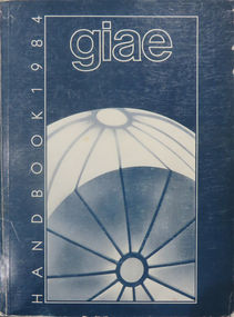
Book, Gippsland Institute of Advanced Education Handbooks, 1970-1985
... Gippsland Institute of Advanced Education Handbooks ....1) 1977 Gippsland Institute of Advanced Education Handbook with white cover .2) 1978 Gippsland Institute of Advanced Education Handbook with blue/black cover .3) 1979 Gippsland Institute of Advanced Education Handbook with orange cover .4) 1980 Gippsland Institute of Advanced Education Handbook with yellow/brown cover .5) 1981 Gippsland Institute of Advanced Education Handbook with grey/black cover .6 1984 Gippsland Institute of Advanced Education Handbook with blue cover .7) 1985 Gippsland Institute of Advanced Education Handbook with purple cover .8) 1989 Gippsland Institute of Advanced Education Handbook with white/purple/grey/red/blue cover .7) 1985 Gippsland Institute of Advanced Education Handbook with pale green cover. .9) 1974 Gippsland Institute of Advanced Education Handbook with orangeand white cover .10) 1975 Gippsland Institute of Advanced Education Handbook with green and white cover .11) 1976 Gippsland Institute of Advanced Education Handbook with white cover .12) 1986 Gippsland Institute of Advanced Education Handbook with mid-blue cover .13) 1987 Gippsland Institute of Advanced Education Handbook with red cover .14) 1988 Gippsland Institute of Advanced Education Handbook with red cover .15) 1973 Gippsland Institute of Advanced Education Handbook with brown cover .16) 1972 Gippsland Institute of Advanced Education Handbook with pale green cover .17) 1971 Gippsland Institute of Advanced Education Handbook with mid-blue cover non-fictiongippsland institute of advanced education, giae, gippsland, churchill, morwell, electricty, handbook, gippsland campus -
 Federation University Historical Collection
Photograph, Ballarat School of Mines Manager of Information Technology, 12/1997
... Ballarat School of Mines Manager of Information Technology ...This image was on a CD-ROM which was placed in a time capsule in December 1997, just before the Ballarat School of Mines merged with the University of Ballarat (now Federation University Australia). The time capsule should have been opened in 2020, the 150th anniversary of the establishment of the Ballarat School of Mines, but was postponed due to successive lockdowns during the Covid19 pandemic. The time capsule was opened in 2022.Ballarat School of Mines Manager of Information Technology, John Dixon, in his office in the Brewery Building.ballarat school of mines, time capsule, information technology, computers, john dixon, brewery building -
Kew Historical Society Inc
Book, Royal Historical Society of Victoria, Faces of Federation : an illustrated history, 2000
... Faces of Federation : an illustrated history...Royal Historical Society of Victoria ...Melbourne : Royal Historical Society of Victoria, 2000 134 p. : ill. ; 28 cm. non-fictionfederal government -- australia -- history, australia -- history -- 1891-1901, constitutional history -- australia, australia -- politics and government -- 1891-1901, australia -- politics and government -- to 1900, australia -- history -- 1788-1900, australia -- constitutional history, australia -- history -- 1891-1901 -- biography -
Victorian Aboriginal Corporation for Languages
Conference proceedings, Tania Ka'ai, Language endangerment in the 21st century : globalisation, technology and new media : proceedings of the conference FEL XVI, 12-15 September 2012, AUT University, Auckland, Aotearoa/?New Zealand, 2012
... , technology and new media : proceedings of the conference FEL XVI, 12 ...Session 1: Technology and Cultural knowledge: Documentation, transmission and resource Session 2: Television and Endangered Languages Session 3: Technology: Archiving, Lexicography, Translation, Databases Session 4: Technology: Teaching and Learning endangered languages Session 5: Social media, press and endangered languages Session 6: Multiple perspectives on language endangerment in the 21st centuryMaps, b&w photographs, tablesendangered languages, language revival, globalisation, technology, barngarla, port lincoln -
 National Vietnam Veterans Museum (NVVM)
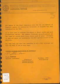
Document, Royal Commission on the Use and Effects of Chemical Agents on Australian Personnel in Vietnam, The Report of the Royal Commission into the Use and Effects of Chemical Agents on Australian Personnel in Vietnam has been considered by the VVAA, 1985
... The Report of the Royal Commission into the Use and Effects...Royal Commission on the Use and Effects of Chemical Agents ...An A4 document on white paper covered in an orange plastic folder with black bindingvietnam war, 1961-1975 -- chemical warfare -- health aspects, agent orange - toxicology herbicides - war use -
University of Melbourne, Burnley Campus Archives
Journal, Royal Society of Victoria, Proceedings of the Royal Society of Victoria, 1935-1945
... Proceedings of the Royal Society of Victoria...Royal Society of Victoria ...A. W. Jessep (Principal) Associate Member. Probably all volumes his property H. W. Gepp Ordinary Member signed on most volumesscience -
 Federation University Historical Collection
Photograph, Gippsland Institute of Advanced Education Staff
... Gippsland Institute of Advanced Education Staff ...Gippsland Institute of Advanced Education is a predecessor institution of Federation University Australia.Gippsland Institute of Advanced Education Staffgippsland institute of advanced education brown coal laboratory technology building, staff -
 Otway Districts Historical Society
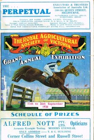
Book, Royal Agricultural Society of Victoria, Schedule of prizes, RASV, 1936, 1936
... Schedule of prizes, RASV, 1936. ...Royal Agricultural Society of Victoria ...Schedule of prizes (including Champion prizes of Australia), Sixty-fifth Grand Agricultural Exhibition, 17th to 26th September, 1936. The Royal Agricultural Society of Victoria; Melbourne (Vic); 1936. 336 p.; illus.; index to advertisers. Soft cover. agriculture; horses; cattle; sheep; pigs; poultry; birds; farm produce; machinery; dairy produce; wine; fruits; -
University of Melbourne, Burnley Campus Archives
Booklet, The University of Melbourne, Institute of Land and Food Resources Campus Information, June 2000
... Institute of Land and Food Resources Campus Information...The University of Melbourne ...campuses, description of campuses, university of melbourne -
 Robin Boyd Foundation
Certificate, Honorary Fellowship to American Institute of Architects, 1960
... Honorary Fellowship to American Institute of Architects ...By the late 1950s, Robin Boyd had developed a network of connections in the United States, and a reputation there as an important architectural critic. In 1960 he was awarded an Honorary Fellowship by the American Institute of Architects. This certificate is dated April 18, 1960, the day earlier than another certificate at Walsh Street (item D492). It is also signed by the President Philip Will Jr. 1960–1962 and the Secretary, Jeremy Leanne (?).Certificate from The American Institute of Architects, with crest, awarding Robin Boyd an Honorary Fellowship. Dated April 18, 1960 and signed by the President, Philip Will Jr, and Secretary Jeremy Leanne. It is inside an envelope.The American Institute of Architects certificate of Honorary Fellowship Robin Boyd eminent architect, citizen of Australia having been admitted to Honorary Fellowship by the Board of Directors in recognition of his distinguished achievements is declared to be an Honorary Fellow The American Institute of Architects entitled to use that title and to enjoy all the privileges of that membership.the american institute of architects, aia fellow, fellowship, robin boyd -
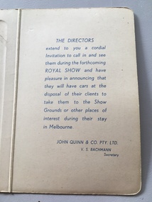 Yarrawonga and Mulwala Pioneer Museum
Souvenir - Invitation card, 1834-1934 Melbourne Centenary Celebrations and Royal Show, 1934
John Quinn and Co were Real Estate agents of Collins Street MelbourneStiff card folding invitation honouring the 1934 Melbourne Centenary Celebrations and inviting clients of John Quinn & Co Pty Ltd to attend the Royal ShowSee photos