Showing 1974 items matching "subdivision"
-
 Ringwood and District Historical Society
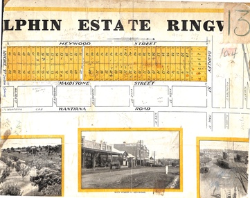
Map, Partially Trimmed Copy of Elphin Estate, Ringwood, Vic. - (Undated, circa 1940s)
... Clipped subdivision map on cardboard backing....Ringwood and District Historical Society 125A Warrandyte Road Ringwood North melbourne Faint handwritten sales notations on and around numbered allotments in Heywood Street, Maidstone Street and Barkly Street, Ringwood.Surrounding streets also include Lutchie Street (later Sylvia Grove) and incorrect spelling of Barkly Street as Barkley. Clipped subdivision map on cardboard backing. Partially Trimmed Copy of Elphin Estate, Ringwood, Vic. - (Undated, circa 1940s) Map ...Clipped subdivision map on cardboard backing.Faint handwritten sales notations on and around numbered allotments in Heywood Street, Maidstone Street and Barkly Street, Ringwood.Surrounding streets also include Lutchie Street (later Sylvia Grove) and incorrect spelling of Barkly Street as Barkley. -
 Kew Historical Society Inc
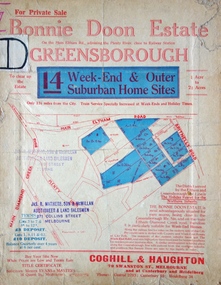
Plan - Subdivision Plan, Bonnie Doon Estate, c.1908
... Pru Sanderson, in her groundbreaking ‘City of Kew Urban Conservation Study : Volume 2 - Development History’ (1988), summarised the periods of urban development and subdivisions of land in Kew. The periods that she identified included 1845-1880, 1880-1893, 1893-1921, 1921-1933, 1933-1943, and Post-War Development. ...The subdivision advertised as the Bonnie Doon Estate in Greensborough was first advertised in 1908. ...Bonnie Doona Estate Subdivision Plans - Greensborough The subdivision advertised as the Bonnie Doon Estate in Greensborough was first advertised in 1908. ...Pru Sanderson, in her groundbreaking ‘City of Kew Urban Conservation Study : Volume 2 - Development History’ (1988), summarised the periods of urban development and subdivisions of land in Kew. The periods that she identified included 1845-1880, 1880-1893, 1893-1921, 1921-1933, 1933-1943, and Post-War Development. These periods were selected as they represented periods of rapid growth or decline in urban development. An obvious starting point for Sanderson’s groupings involved population growth and the associated economic cycles. These cycles also highlighted urban expansion onto land that was predominantly rural, although in other cases it represented the decline and breakup of large estates. A number of the plans in the Kew Historical Society’s collection can also be found in other collections, such as those of the State Library of Victoria and the Boroondara Library Service. A number are however unique to the collection.The Kew Historical Society collection includes almost 100 subdivision plans pertaining to suburbs of the City of Melbourne. Most of these are of Kew, Kew East or Studley Park, although a smaller number are plans of Camberwell, Deepdene, Balwyn and Hawthorn. It is believed that the majority of the plans were gifted to the Society by persons connected with the real estate firm - J. R. Mathers and McMillan, 136 Cotham Road, Kew. The Plans in the collection are rarely in pristine form, being working plans on which the agent would write notes and record lots sold and the prices of these. The subdivision plans are historically significant examples of the growth of urban Melbourne from the beginning of the 20th Century up until the 1980s. A number of the plans are double-sided and often include a photograph on the reverse. A number of the latter are by noted photographers such as J.E. Barnes.The subdivision advertised as the Bonnie Doon Estate in Greensborough was first advertised in 1908. At that stage, the new subdivision included 15 allotments of between one and four acres. By the time the subdivision plan in the Kew Collection was created, only 12 lots of between ¾ and 2½ acres remained. Both the State Library and Kew plans emphasise the distance to the city being 13½ miles, which could be reached by train on weekdays and weekends. Unusually, the plan describes the suitability of lots as locations for ‘Week-end Homes’. Correspondingly, the train line is described as ‘The Holiday Resort for the Northern Suburbs’.bonnie doona estate, subdivision plans - greensborough -
 Ringwood and District Historical Society
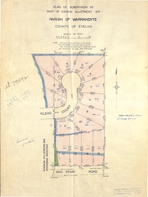
Document - Real Estate Folder, Savernake Estate, Ringwood, Victoria - Stage two - circa 1967
... Plan of Subdivision PS79692, Part of Crown Allotment 31A Parish of Warrandyte, and advertisement for sale of residential allotments with map showing layout of Stage 2 of subdivision. ....: 7233298, 8782648. Subdivision Plan stamped Donald Cameron Consultants Pty. ....: 7233298, 8782648. Subdivision Plan stamped Donald Cameron Consultants Pty. ...Plan of Subdivision PS79692, Part of Crown Allotment 31A Parish of Warrandyte, and advertisement for sale of residential allotments with map showing layout of Stage 2 of subdivision. Typewritten details for first and second release of Lots 10 to 16 with Terms of sale, stapled to two advertising flyers featuring map of estate showing Lots 1 to 20 on Evelyn Road, Cameron Road, Klead Court, and San Remo Road. Green slip included dated 6 July 1979 showing description of property at Lot 14 (no.4) San Remo Road, vendor - Judith Margaret Love and Lindsale Stephen Love, Cherry Tree Downs, Tarwin Lower 3456. Phone 056635390 Bus 056787203.Agent - C.E. Carter & Son, R.E.S.I. 126 Whitehorse Road, Ringwood. Telephones: 8706024, 8706830, 8702519, A.H.: 7233298, 8782648. Subdivision Plan stamped Donald Cameron Consultants Pty. Ltd., Consulting Engineers, 472 Bourke Street Melbourne - 67-2602. -
 Ringwood and District Historical Society
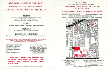
Flyer, Land Auction Advertisement adjoining Jubilee Park, Ringwood, Victoria - 1956
... Folded double-sided brochure advertising residential land sale auction on Saturday 24th March (1956), with locality map and subdivision layout, terms of sale, and summary of local features and services. ...Subdivision includes Reilly Street Ringwood, and Philip Street, Daisy Street, and Lorienne Street Heathmont. ...Ringwood and District Historical Society 125A Warrandyte Road Ringwood North melbourne Subdivision includes Reilly Street Ringwood, and Philip Street, Daisy Street, and Lorienne Street Heathmont. ...Folded double-sided brochure advertising residential land sale auction on Saturday 24th March (1956), with locality map and subdivision layout, terms of sale, and summary of local features and services. Subdivision includes Reilly Street Ringwood, and Philip Street, Daisy Street, and Lorienne Street Heathmont. Surveyors - Messrs Little and Brosnan. Agents in Conjunction - Peter Martin Pty. Ltd., Estate Agents, 55-57 Latrobe Street, Melbourne (Phone) FB 3571, FB 2783, and Peter Aubin Pty. Ltd. R.E.S.I., Auctioneers & Estate Agents, 345 Lonsdale Street, Dandenong (Phone) Dandenong 340, After Hours, Dandenong 932, 70. -
 Ringwood and District Historical Society
Flyer, Residential Land Sale Brochure, Peppermint Park, Heathmont, Vic. - 2010
... Double-sided A3 size advertisement for Peppermint Park, Heathmont, Victoria, advertising sale of ten homesites with diagram showing locality map, size of blocks and layout of streets within and around the subdivision....Subdivision layout includes Pleasant Drive, Swain Court and Barbara Court off Culverlands Road and Armstrong Road in Heathmont. ...Ringwood and District Historical Society 125A Warrandyte Road Ringwood North melbourne Subdivision layout includes Pleasant Drive, Swain Court and Barbara Court off Culverlands Road and Armstrong Road in Heathmont. ...Double-sided A3 size advertisement for Peppermint Park, Heathmont, Victoria, advertising sale of ten homesites with diagram showing locality map, size of blocks and layout of streets within and around the subdivision.Subdivision layout includes Pleasant Drive, Swain Court and Barbara Court off Culverlands Road and Armstrong Road in Heathmont. Agents - Carter Real Estate Agency, 90 Maroondah Highway, Ringwood Vic 3134 (Telephone) 98706211. Auctioneers - Richard Carter & William Lyall - 0411823337. Handwritten price list notations included, and Stage 2 Plan digitally signed by Michael Herwald Hipfel, Licensed Surveyor, 10/2/1916. -
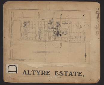 Kew Historical Society Inc
Plan - Subdivision Plan, Altyre Estate, 1920, 1920
... Pru Sanderson, in her groundbreaking ‘City of Kew Urban Conservation Study : Volume 2 - Development History’ (1988), summarised the periods of urban development and subdivisions of land in Kew. The periods that she identified included 1845-1880, 1880-1893, 1893-1921, 1921-1933, 1933-1943, and Post-War Development. ...The subdivision included fifty-one allotments as well as the original house ‘Altyre’ in Barkers Road. ...Altyre Estate, 1920 Plan Subdivision Plan ...Pru Sanderson, in her groundbreaking ‘City of Kew Urban Conservation Study : Volume 2 - Development History’ (1988), summarised the periods of urban development and subdivisions of land in Kew. The periods that she identified included 1845-1880, 1880-1893, 1893-1921, 1921-1933, 1933-1943, and Post-War Development. These periods were selected as they represented periods of rapid growth or decline in urban development. An obvious starting point for Sanderson’s groupings involved population growth and the associated economic cycles. These cycles also highlighted urban expansion onto land that was predominantly rural, although in other cases it represented the decline and breakup of large estates. A number of the plans in the Kew Historical Society’s collection can also be found in other collections, such as those of the State Library of Victoria and the Boroondara Library Service. A number are however unique to the collection.The Kew Historical Society collection includes almost 100 subdivision plans pertaining to suburbs of the City of Melbourne. Most of these are of Kew, Kew East or Studley Park, although a smaller number are plans of Camberwell, Deepdene, Balwyn and Hawthorn. It is believed that the majority of the plans were gifted to the Society by persons connected with the real estate firm - J. R. Mathers and McMillan, 136 Cotham Road, Kew. The Plans in the collection are rarely in pristine form, being working plans on which the agent would write notes and record lots sold and the prices of these. The subdivision plans are historically significant examples of the growth of urban Melbourne from the beginning of the 20th Century up until the 1980s. A number of the plans are double-sided and often include a photograph on the reverse. A number of the latter are by noted photographers such as J.E. Barnes.The Altyre Estate was advertised for sale by auction in 1920. A colour lithograph in the State Library of Victoria, in contrast to this monochrome version, notes the proximity of the subdivision to the Auburn Heights Bowling Club and to a range of transport options. The subdivision included fifty-one allotments as well as the original house ‘Altyre’ in Barkers Road. This version includes the amounts paid as deposit on a number of lots.subdivision plans - kew, altyre estate – kew (vic), barkers road – kew (vic), walsh street – kew (vic), ross street – kew (vic), loxton street – kew (vic), mount street – kew (vic), auburn heights bowling club, altyre -
![Escol Estate [Kew], 1940](/media/collectors/550653872162f11fb04854aa/items/59115843d0ce2b1f048f0fbb/item-media/591158fdd0ce2e1f04f1e0f5/item-fit-380x285.jpg?cb=6) Kew Historical Society Inc
Kew Historical Society IncPlan - Subdivision Plan, Escol Estate [Kew], 1940, 1940
... Pru Sanderson, in her groundbreaking ‘City of Kew Urban Conservation Study : Volume 2 - Development History’ (1988), summarised the periods of urban development and subdivisions of land in Kew. The periods that she identified included 1845-1880, 1880-1893, 1893-1921, 1921-1933, 1933-1943, and Post-War Development. ...The ‘Escol Estate’ was a subdivision, which created Bramley Court, which runs south from Sackville Street between Evans Road and Orford Avenue. ...Escol Estate [Kew], 1940 Plan Subdivision Plan ...Pru Sanderson, in her groundbreaking ‘City of Kew Urban Conservation Study : Volume 2 - Development History’ (1988), summarised the periods of urban development and subdivisions of land in Kew. The periods that she identified included 1845-1880, 1880-1893, 1893-1921, 1921-1933, 1933-1943, and Post-War Development. These periods were selected as they represented periods of rapid growth or decline in urban development. An obvious starting point for Sanderson’s groupings involved population growth and the associated economic cycles. These cycles also highlighted urban expansion onto land that was predominantly rural, although in other cases it represented the decline and breakup of large estates. A number of the plans in the Kew Historical Society’s collection can also be found in other collections, such as those of the State Library of Victoria and the Boroondara Library Service. A number are however unique to the collection.The Kew Historical Society collection includes almost 100 subdivision plans pertaining to suburbs of the City of Melbourne. Most of these are of Kew, Kew East or Studley Park, although a smaller number are plans of Camberwell, Deepdene, Balwyn and Hawthorn. It is believed that the majority of the plans were gifted to the Society by persons connected with the real estate firm - J. R. Mathers and McMillan, 136 Cotham Road, Kew. The Plans in the collection are rarely in pristine form, being working plans on which the agent would write notes and record lots sold and the prices of these. The subdivision plans are historically significant examples of the growth of urban Melbourne from the beginning of the 20th Century up until the 1980s. A number of the plans are double-sided and often include a photograph on the reverse. A number of the latter are by noted photographers such as J.E. Barnes.The ‘Escol Estate’ was a subdivision, which created Bramley Court, which runs south from Sackville Street between Evans Road and Orford Avenue. The subdivision was comprised of 12 lots. At the auction of the lots in May 1940, eight of the 12 allotments were sold. The land was sold subject to a restriction of only one private residence being erected on each lot.subdivision plans - kew, sackville street – kew (vic.), bramley court – kew (vic.) -
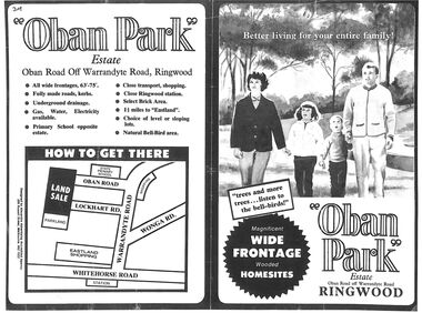 Ringwood and District Historical Society
Flyer, Land Sale Advertisement, Oban Park Estate, Ringwood, Vic. - 1969
... One double-sided and two single-sided pages advertising Oban Park Estate land sale, including terms of sale, locality map, subdivision features and summary of local services....Subdivision includes Oban Road, Terrigal Close, Dorelaw Drive (later Melview Drive), Naroo Court, Barook Court, and Lockhart Road. ...Ringwood and District Historical Society 125A Warrandyte Road Ringwood North melbourne Subdivision includes Oban Road, Terrigal Close, Dorelaw Drive (later Melview Drive), Naroo Court, Barook Court, and Lockhart Road. ...One double-sided and two single-sided pages advertising Oban Park Estate land sale, including terms of sale, locality map, subdivision features and summary of local services.Subdivision includes Oban Road, Terrigal Close, Dorelaw Drive (later Melview Drive), Naroo Court, Barook Court, and Lockhart Road. Agents in Conjunction: E. Wachman, Melbourne, Hutchinson Real Estate, Ashwood, and A.W. Dickson, 136 Whitehorse Road, Ringwood (Phone) 870-6007 A.H. 882967. Separate newspaper advertisement (digital only) shows agents - Hutchison Real Estate (Telephone 277-2326) and Michelson Gelfand Pty Ltd (Telephone 53-8151). -
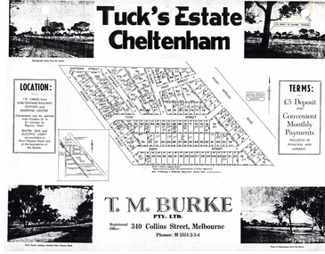 City of Moorabbin Historical Society (Operating the Box Cottage Museum)
Flyer - Tuck's Estate, Cheltenham, 1940
... Tuck's Estate Cheltenham - plan of subdivision...Example of the progress of the Municipality of Moorabbin Edward Street Point Nepean Road Eden Street Tuck Street Hoffman Street Elman Road Page street Cheltenham real Estates Auction Tuck Tuck's Estate Cheltenham - plan of subdivision Photocopy of advertising flyer for sale of real estate sales - plan of building blocks for sale Flyer Tuck's Estate, Cheltenham ...After WWII there was a decline in the market gardens in the City of Moorabbin, as the value of the land was more profitable than the crops.Example of the progress of the Municipality of MoorabbinPhotocopy of advertising flyer for sale of real estate sales - plan of building blocks for saleTuck's Estate Cheltenham - plan of subdivisionedward street, point nepean road, eden street, tuck street, hoffman street, elman road, page street, cheltenham, real estates, auction, tuck -
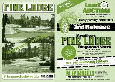 Ringwood and District Historical Society
Flyer, Land Auction Sale Brochure, Pine Lodge, Ringwood North, Victoria - 3rd Release 1978
... Green tri-fold advertisement for auction of home sites, with map of subdivision, photographs, and summary of local features and services for Pine Lodge, Kalinda Road, Ringwood North - 3rd release - Auction date, Saturday, 18th November, 1978, at 2:30pm....Subdivision plan includes Mundara Drive, Bidston Court, Parkgate Drive, Frodsham Road, and Bebington Close. ...No. 5171 for Pine Lodge Land Auction previous release, 1977. Subdivision plan includes Mundara Drive, Bidston Court, Parkgate Drive, Frodsham Road, and Bebington Close. ...Refer also to Reg. No. 5171 for Pine Lodge Land Auction previous release, 1977.Green tri-fold advertisement for auction of home sites, with map of subdivision, photographs, and summary of local features and services for Pine Lodge, Kalinda Road, Ringwood North - 3rd release - Auction date, Saturday, 18th November, 1978, at 2:30pm.Subdivision plan includes Mundara Drive, Bidston Court, Parkgate Drive, Frodsham Road, and Bebington Close. (Agent) N.R. Reid & Co. Pty. Ltd., 10A Hewish Road, Croydon (Phone) 725 0999, 450 Little Collins Street, Melbourne (Phone) 67 1746, and 207 Stud Road, Wantirna South (Phone) 221 2222. -
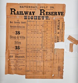 City of Kingston
Pamphlet - Colour, Duffus Bros, Railway Reserve Highett, c. 1923
... Handwritten in grey pencil: assumed sale price recorded on subdivisions 1-7, 10, 22, 23 and 34 Handwritten in grey pencil on subdivision 4: C. ...Nevill / City of Melbourne bank Handwritten in grey pencil across subdivision 7: 49' Handwritten in grey pencil across subdivision 21 and 22: 134' Handwritten in grey pencil across subdivision 25 and 26: 200' Handwritten in grey pencil across subdivision 36 and 37 and both top and bottom: 120' Hand drawn in blue pencil: outline of subdivision 4 Hand drawn in blue pencil: outline of subdivisions 7, 23, 28, 37, 38 along left hand side, subdivisions 38, 37 and 36 on Wolseley Street, subdivisions 30 and 29 along Wolseley Street, subdivisions 29 and 24 along the middle of the plan, subdivisions 24 and half of 25 along Livingston Street, half of subdivision 20 along the middle of the plan, subdivisions 21 and 22 along the Right of Way between Livingston Street and Highett Road, and along the right hand border of subdivision 7. ...Sales plan for land in the suburb of Highett, titled Railway Reserve, incorporating properties along Wolseley Street, Livingston Street, Highett Road and Worthing Road. The developing urban area of Highett within the City of Kingston. This land sale pamphlet illustrates the subdivision of land within the municipality and the changing demographic of the district as new houses and shops are constructed close to infrastructure.Colour pamphlet advertising thirty eight shop and villa sites for sale at the Railway Reserve, Highett. Incorporates a map of the reserve with properties available on Wolseley Street, Livingston Street, Highett Road and Worthing Road. Handwritten in grey pencil: assumed sale price recorded on subdivisions 1-7, 10, 22, 23 and 34 Handwritten in grey pencil on subdivision 4: C. Nevill / City of Melbourne bank Handwritten in grey pencil across subdivision 7: 49' Handwritten in grey pencil across subdivision 21 and 22: 134' Handwritten in grey pencil across subdivision 25 and 26: 200' Handwritten in grey pencil across subdivision 36 and 37 and both top and bottom: 120' Hand drawn in blue pencil: outline of subdivision 4 Hand drawn in blue pencil: outline of subdivisions 7, 23, 28, 37, 38 along left hand side, subdivisions 38, 37 and 36 on Wolseley Street, subdivisions 30 and 29 along Wolseley Street, subdivisions 29 and 24 along the middle of the plan, subdivisions 24 and half of 25 along Livingston Street, half of subdivision 20 along the middle of the plan, subdivisions 21 and 22 along the Right of Way between Livingston Street and Highett Road, and along the right hand border of subdivision 7. Handwritten in ink adjacent to the subdivision plan, updside down, in the bottom right hand corner: 276 / 54 / 280 / 45 / 320 / 202 / 200 / 134 / horizontal line / 11/14 Handwritten in ink adjacent to the subdivision plan, updside down, in the bottom right hand corner: 1714)2200(15 / 1714 / horizontal line / 486land sales, highett -
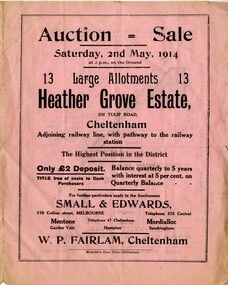 City of Kingston
Pamphlet - Colour, Moorabbin News Print, Auction = Sale Heather Grove Estate, c. 1914
... Handwritten in grey pencil on subdivision 1: Sold / 20/- Handwritten in grey pencil on subdivision 2: 25/- Handwritten in grey pencil on subdivision 3: 30/- Handwritten in grey pencil on subdivision 4: 110 / 30/- Handwritten in grey pencil on subdivisions 1, 11, 10, 9 and 8: Sold Handwritten in grey pencil beneath 'Heather Grove': 20/- 20/- 20/- 20/- Handwritten in black ink on subdivison 12 and 7: £85 Handwritten in back ink on subdivision 5: £60 Handwritten in back ink on subdivision 6: £65 Handwritten in grey pencil above subdivision map: 1-8-9-10-11 Handwritten in grey pencil above subdivision map: [enclosed in a circle] 12- / £75 Handwritten in grey pencil above subdivision map: [enclosed in a circle] 2 / £85 Handwritten in grey pencil above subdivision map: [enclosed in a circle] 3 / £100 Handwritten in grey pencil above subdivision map: [enclosed in a circle] 4 / £100 Handwritten in grey pencil above subdivision map: [enclosed in a circle] 5 / £60 Handwritten in grey pencil above subdivision map: [enclosed in a circle] 6 / £65 Handwritten in grey pencil above subdivision map: [enclosed in a circle] 7 / £25- Handwritten in grey pencil above subdivision map: [enclosed in a circle] £125 / [indecipherable] Handwritten in grey pencil above subdivision map: 37.00 / 18.10 / 56.80 / 3 / [horizontal line] / 59 8 Handwritten in grey pencil along railway line marking: 21/6 / 12/6 / 13/- / 19/-...Land sales estate Cheltenham Handwritten in grey pencil on subdivision 1: Sold / 20/- Handwritten in grey pencil on subdivision 2: 25/- Handwritten in grey pencil on subdivision 3: 30/- Handwritten in grey pencil on subdivision 4: 110 / 30/- Handwritten in grey pencil on subdivisions 1, 11, 10, 9 and 8: Sold Handwritten in grey pencil beneath 'Heather Grove': 20/- 20/- 20/- 20/- Handwritten in black ink on subdivison 12 and 7: £85 Handwritten in back ink on subdivision 5: £60 Handwritten in back ink on subdivision 6: £65 Handwritten in grey pencil above subdivision map: 1-8-9-10-11 Handwritten in grey pencil above subdivision map: [enclosed in a circle] 12- / £75 Handwritten in grey pencil above subdivision map: [enclosed in a circle] 2 / £85 Handwritten in grey pencil above subdivision map: [enclosed in a circle] 3 / £100 Handwritten in grey pencil above subdivision map: [enclosed in a circle] 4 / £100 Handwritten in grey pencil above subdivision map: [enclosed in a circle] 5 / £60 Handwritten in grey pencil above subdivision map: [enclosed in a circle] 6 / £65 Handwritten in grey pencil above subdivision map: [enclosed in a circle] 7 / £25- Handwritten in grey pencil above subdivision map: [enclosed in a circle] £125 / [indecipherable] Handwritten in grey pencil above subdivision map: 37.00 / 18.10 / 56.80 / 3 / [horizontal line] / 59 8 Handwritten in grey pencil along railway line marking: 21/6 / 12/6 / 13/- / 19/- Colour pamphlet advertising auction of Heather Grove Estate, Cheltenham. ...Sales plan for land in the suburb of Cheltenham, bounded by Tulip Grove and Heather Grove.The developing urban area of Highett within the City of Kingston. This land sale pamphlet illustrates the subdivision of land within the municipality and the changing demographic of the district as new houses are constructed close to infrastructure.Colour pamphlet advertising auction of Heather Grove Estate, Cheltenham. Incorporates a map of the estate bordered by Wickham Road, Railway Parade, Highett Road and Point Nepean Road.Handwritten in grey pencil on subdivision 1: Sold / 20/- Handwritten in grey pencil on subdivision 2: 25/- Handwritten in grey pencil on subdivision 3: 30/- Handwritten in grey pencil on subdivision 4: 110 / 30/- Handwritten in grey pencil on subdivisions 1, 11, 10, 9 and 8: Sold Handwritten in grey pencil beneath 'Heather Grove': 20/- 20/- 20/- 20/- Handwritten in black ink on subdivison 12 and 7: £85 Handwritten in back ink on subdivision 5: £60 Handwritten in back ink on subdivision 6: £65 Handwritten in grey pencil above subdivision map: 1-8-9-10-11 Handwritten in grey pencil above subdivision map: [enclosed in a circle] 12- / £75 Handwritten in grey pencil above subdivision map: [enclosed in a circle] 2 / £85 Handwritten in grey pencil above subdivision map: [enclosed in a circle] 3 / £100 Handwritten in grey pencil above subdivision map: [enclosed in a circle] 4 / £100 Handwritten in grey pencil above subdivision map: [enclosed in a circle] 5 / £60 Handwritten in grey pencil above subdivision map: [enclosed in a circle] 6 / £65 Handwritten in grey pencil above subdivision map: [enclosed in a circle] 7 / £25- Handwritten in grey pencil above subdivision map: [enclosed in a circle] £125 / [indecipherable] Handwritten in grey pencil above subdivision map: 37.00 / 18.10 / 56.80 / 3 / [horizontal line] / 59 8 Handwritten in grey pencil along railway line marking: 21/6 / 12/6 / 13/- / 19/-land sales, estate, cheltenham -
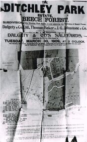 Otway Districts Historical Society
Photograph, Knox Collection, Sale of the Ditchley Park Estate, Beech Forest, 1908
... There were very few takers for these lots nor any buyers for the Ditchley subdivision....Ltd. will sell the subdivision of the Ditchley Park Estate on Tuesday, March 30, 1909, at 2 o'clock. ...Ltd. will sell the subdivision of the Ditchley Park Estate on Tuesday, March 30, 1909, at 2 o'clock. ...Commercial realities and bushfires caused the Beech Forest community to re-establish itself around the railway station, away from Gardner Hill. This caused John W. Gardner to subdivide his land on the north side of the railway station. One subdivision was created near the Ditchley railway station on the old racecourse site, and another of 25 allotments forming what became Southorn Street. There were very few takers for these lots nor any buyers for the Ditchley subdivision.Photocopy. 260mm x 159mm. An advertisement for the sale of the Ditchley Park Estate, Beech Forest. Under instructions from Mr. J.W. Gardner Dalgety & Co. Ltd. will sell the subdivision of the Ditchley Park Estate on Tuesday, March 30, 1909, at 2 o'clock. A map of Beech Forest township and the Ditchley Park Estate is attached, as are the terms of sale and a description of the area.. beech forest; ditchley park; land sale; advertisment; -
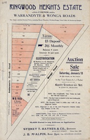 Ringwood and District Historical Society
Flyer, Land Auction Sale Advertisement - Ringwood Heights Estate, Ringwood, Victoria - circa 1923
... - Ringwood Heights Estate, corner Warrandyte and Wonga Roads, North Ringwood, with terms of sale, summary of local features and services, and map showing layout of subdivision...Subdivision includes Wonga Road and Anderson's Creek Road (later Warrandyte Road). ...Ringwood and District Historical Society 125A Warrandyte Road Ringwood North melbourne Subdivision includes Wonga Road and Anderson's Creek Road (later Warrandyte Road). ...Advertisement for land and weatherboard villa auction sale on Saturday, January 13 (1923?) - Ringwood Heights Estate, corner Warrandyte and Wonga Roads, North Ringwood, with terms of sale, summary of local features and services, and map showing layout of subdivisionSubdivision includes Wonga Road and Anderson's Creek Road (later Warrandyte Road). Agents - Sydney T. Haynes & Co., Auctioneers, 60 Queen Street, Melbourne. Phone Central 3400; J.B. McAlpin, Estate Agent, Opposite Ringwood Station. Auction in the Trust Estate of J.J. Parker, instructed by the Equity Trustees Co. Ltd. 85 Queen Street, Melbourne. -
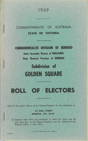 Bendigo Historical Society Inc.
Book - ROLL OF ELECTORRS - GOLDEN SQUARE 1969
... Roll of electors, subdivision of Golden Square - 1969...History House 11 Mackenzie Street Bendigo goldfields GOVERNMENT State electoral roll Roll of electors, subdivision of Golden Square - 1969 Book ROLL OF ELECTORRS - GOLDEN SQUARE 1969 ...Roll of electors, subdivision of Golden Square - 1969government, state, electoral roll -
 Ringwood and District Historical Society
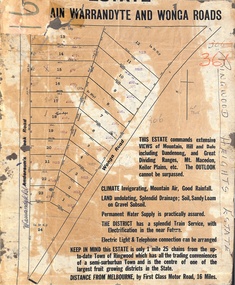
Map, Partially Trimmed Copy of Ringwood Heights Estate, Ringwood, Vic. - circa 1923
... Clipped copy of a subdivision advertisement on cardboard backing. ...Clipped copy of a subdivision advertisement on cardboard backing. ...Clipped copy of a subdivision advertisement on cardboard backing. Sales notations on numbered allotments in Andersons's Creek Road (later Warrandyte Road) and Wonga Road, Ringwood. Handwritten title reference - LP7305. Captions - This Estate commands extensive views of mountain, hill and dale including Dandenong and Great Dividing Ranges, Mt. Macedon, Keilor Plains, etc. The outlook cannot be surpassed. Climate invigorating, mountain air, good rainfall. Land undulating, splendid drainage; soil, sandy loam on gravel subsoil. Permanent water supply is practically assured. The district has a splendid train service, with electrification in the near future. Electric light & telephone connection can be arranged. Keep in mind this estate is only 1 mile 25 chains from the up-to-date town of Ringwood which has all the trading conveniences of a semi-suburban town and is the centre of one of the largest fruit growing districts in the state. Distance from Melbourne by first class motor road, 16 miles. -
 Lakes Entrance Historical Society
Map - Shire of Tambo Lakes Entrance
... Streets and subdivisions of Lakes Entrance. 2 pages...Lakes Entrance Historical Society 4 Marine Parade Lakes Entrance gippsland Townships Waterways Roads and Streets Streets and subdivisions of Lakes Entrance. 2 pages Map Shire of Tambo Lakes Entrance ...Streets and subdivisions of Lakes Entrance. 2 pagestownships, waterways, roads and streets -
Stawell Historical Society Inc
Map, The Litho Co Ballarat, Glyntowyn Estate Campbells Bridge 1909, 1909
... Paper map / Poster Advertising Subdivision of Estate...Stawell Historical Society Inc 46 Longfield St Stawell grampians Shows Hoestead CC McCulloch ESQ Farming Mitchell Bros & White. 5003 Acres The Litho Co Ballarat Black Printing with Red Coloured Sections Paper map / Poster Advertising Subdivision of Estate Glyntowyn Estate Campbells Bridge 1909 Map The Litho Co Ballarat ...Shows Hoestead CC McCulloch ESQPaper map / Poster Advertising Subdivision of EstateMitchell Bros & White. 5003 Acres The Litho Co Ballarat Black Printing with Red Coloured Sectionsfarming -
 Ringwood and District Historical Society
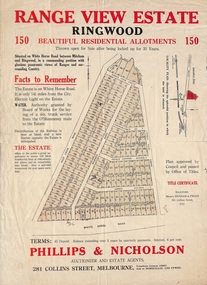
Flyer, Land Sale Advertisement and auction notice - Range View Estate, Ringwood, Victoria - 1920
... Advertisement for sale of 150 residential allotments with terms of sale, summary of local features and services, and map showing location and layout of subdivision within the boundary of Mitcham to the west of Ringwood, Victoria. ...Subdivision includes Deep Creek Road, Range View Grove, Warnes Road, Tarrangower Avenue, Prince Edward Avenue, James Avenue, and White Horse Road, Mitcham. ...Ringwood and District Historical Society 125A Warrandyte Road Ringwood North melbourne Subdivision includes Deep Creek Road, Range View Grove, Warnes Road, Tarrangower Avenue, Prince Edward Avenue, James Avenue, and White Horse Road, Mitcham. ...Advertisement for sale of 150 residential allotments with terms of sale, summary of local features and services, and map showing location and layout of subdivision within the boundary of Mitcham to the west of Ringwood, Victoria. Copy of newspaper advertisement (The Herald, Melbourne, Wednesday 3 March, 1920) refers to public auction date for Range View Estate Ringwood - Saturday, 27th March, 1920.Subdivision includes Deep Creek Road, Range View Grove, Warnes Road, Tarrangower Avenue, Prince Edward Avenue, James Avenue, and White Horse Road, Mitcham. Agents - Phillips & Nicholson, 281 Collins Street, Melbourne, Telephone Central 10907. -
 Kew Historical Society Inc
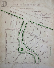
Plan, Studley Heights Estate, 1936
... Pru Sanderson, in her groundbreaking ‘City of Kew Urban Conservation Study : Volume 2 - Development History’ (1988), summarised the periods of urban development and subdivisions of land in Kew. The periods that she identified included 1845-1880, 1880-1893, 1893-1921, 1921-1933, 1933-1943, and Post-War Development. ...The seventeen allotments in the subdivision fronted Hyton Crescent and Studley Park Road....The seventeen allotments in the subdivision fronted Hyton Crescent and Studley Park Road. ...Pru Sanderson, in her groundbreaking ‘City of Kew Urban Conservation Study : Volume 2 - Development History’ (1988), summarised the periods of urban development and subdivisions of land in Kew. The periods that she identified included 1845-1880, 1880-1893, 1893-1921, 1921-1933, 1933-1943, and Post-War Development. These periods were selected as they represented periods of rapid growth or decline in urban development. An obvious starting point for Sanderson’s groupings involved population growth and the associated economic cycles. These cycles also highlighted urban expansion onto land that was predominantly rural, although in other cases it represented the decline and breakup of large estates. A number of the plans in the Kew Historical Society’s collection can also be found in other collections, such as those of the State Library of Victoria and the Boroondara Library Service. A number are however unique to the collection.Subdivision plans are historically important documents used as evidence of the growth of suburbs in Australia. They frequently provide information about when the land was sold on which a built structure was subsequently constructed as well as evidence relating to surveyors and real estate and financial agents. The numerous subdivision plans in the Kew Historical Society's collection represent working documents, ranging from the initial sketches made in planning a subdivision to printed plans on which auctioneers or agents listed the prices for which individual lots were sold. In a number of cases, the reverse of a subdivision plan in the collection includes a photograph of a house that was also for sale by the agent. These photographs provide significant heritage information relating house design and decoration, fencing and household gardens.The ‘Studley Heights Estate’ on the South Side of Studley Park Road was launched in 1936. The seventeen allotments in the subdivision fronted Hyton Crescent and Studley Park Road.subdivision plans - kew, studley heights estate -
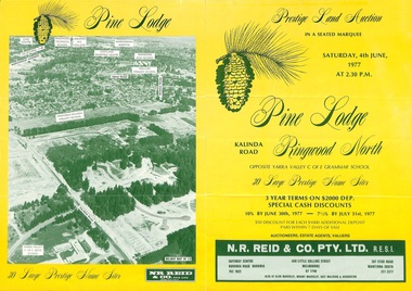 Ringwood and District Historical Society
Flyer, Land Auction Sale Brochure, Pine Lodge, Ringwood North, Victoria - 1977
... Yellow double-sided real estate auction notice with green print showing aerial photograph and map of subdivision layout and summary of local features and services for Pine Lodge, Kalinda Road, Ringwood North. ...Subdivision plan includes Parkgate Drive, Wood-Church Close, and Pensby Court. ...No. 5172 for Pine Lodge Land Auction 3rd release, 1978. Subdivision plan includes Parkgate Drive, Wood-Church Close, and Pensby Court. ...Refer also to Reg. No. 5172 for Pine Lodge Land Auction 3rd release, 1978.Yellow double-sided real estate auction notice with green print showing aerial photograph and map of subdivision layout and summary of local features and services for Pine Lodge, Kalinda Road, Ringwood North. Auction date, Saturday, 4th June, 1977, at 2:30pm.Subdivision plan includes Parkgate Drive, Wood-Church Close, and Pensby Court. (Agent) N.R. Reid & Co. Pty. Ltd., Safeway Centre, Boronia Road, Boronia (Phone) 762 1022, 450 Little Collins Street, Melbourne (Phone) 67 1746, and 207 Stud Road, Wantirna South (Phone) 231 2277. -
Kew Historical Society Inc
Plan - Camberwell Panorama Estate, 1923
... Subdivision plans and real estate flyers/brochures reveal a number of aspects of urban development and history. ...Other streets in the subdivision include: Sunburst Avenue, The Moor, and Macedon Avenue. ...Other streets in the subdivision include: Sunburst Avenue, The Moor, and Macedon Avenue. ...Subdivision plans and real estate flyers/brochures reveal a number of aspects of urban development and history. The Kew Historical Society's collection of these plans, as well as advertisements extracted from magazines, cover key aspects of community development and architectural history of Kew and Kew Eat as well as surrounding suburbs. While most of the plans in the collection were gifted to the Society by the former City of Kew, a number of other plans and advertisements have been donated by individuals, of which this is an example.Promotional brochure for the Camberwell Panorama Estate. The four page bifold handout advertises 216 home sites bounded by Bulleen Road, The Nook, Fortuna Avenue, and Doncaster Road. Other streets in the subdivision include: Sunburst Avenue, The Moor, and Macedon Avenue. The brochure has been damaged at some time in the past and so masking tape obscures the tram on page 1. Page 2 includes the plan of the subdivision, page 3 information about the site and a locality plan, while page 4 includes photographs and terms of sale. subdivision plans -- balwyn north (vic.), camberwell panorama estate -
Kew Historical Society Inc
Plan - Willsmere Park Estate, Kew, 1926
... Subdivision plans and real estate flyers/brochures reveal a number of aspects of urban development and history. ...Original 4-page, bifold subdivision plan of the Willsmere Park Estate, Kew. ...Willsmere park Estate -- Kew (Vic.) subdivisions - kew (Vic.) subdivisions -- kew east (Vic.) willsmere park -- Kew East (Vic.) ...Subdivision plans and real estate flyers/brochures reveal a number of aspects of urban development and history. The Kew Historical Society's collection of these plans, as well as advertisements extracted from magazines, cover key aspects of community development and architectural history of Kew and Kew Eat as well as surrounding suburbs. While most of the plans in the collection were gifted to the Society by the former City of Kew, a number of other plans and advertisements have been donated by individuals, of which this is an example.Original 4-page, bifold subdivision plan of the Willsmere Park Estate, Kew. The 1926 land sale advertised '40 superb villa allotments' on the 'Yarra Heights'. Streets within the subdivision included: Willow Grove, Kilby Road, Elm Grove and Belford Road. The double page spread on pages 2 and 3 shows the detailed plan of the 40 lots, surrounded by public parkland [Willsmere Park] and the Kew Golf Links. By the time that this version of the plan was released, only the lots on Willow Grove and Kilby Road remained. willsmere park estate -- kew (vic.), subdivisions - kew (vic.), subdivisions -- kew east (vic.), willsmere park -- kew east (vic.) -
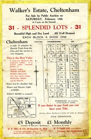 City of Kingston
Pamphlet - Colour, H. R. Hill & Co, Walker's Estate, Cheltenham for sale by public auction, c. 1923
... Handwritten in black pen on subdivision map: 'x' written on subdivisions 2, 3, 8-11, 15-17, 19. ...Handwritten in black pen on subdivision map: assumed sale price on subdivisions 1, 4-7, 12-14, 18, 20-31. ...Sales plan for land in the suburb of Cheltenham, encompassing both sides of Walker Grove, a section of Centre Dandenong Rd and Axelton St. The developing urban area of Cheltenham within the City of Kingston. This land sale pamphlet illustrates the subdivision of land within the municipality and the changing demographic of the district as new houses are constructed.Black and white pamphlet advertising for private sale the Station Entrance Estate, Highett. Incorporates a map of the estate bordered by Wickham Road, Railway Parade, Highett Road and Point Nepean Road.Handwritten in black pen on subdivision map: 'x' written on subdivisions 2, 3, 8-11, 15-17, 19. Potentially indicating that these properties did not sell at auction. Handwritten in black pen on subdivision map: assumed sale price on subdivisions 1, 4-7, 12-14, 18, 20-31. land sales, cheltenham, estate -
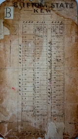 Kew Historical Society Inc
Plan - Subdivision Plan, Jas R Mathers Son & McMillan, Clifton Estate, Kew, c. 1916
... Pru Sanderson, in her groundbreaking ‘City of Kew Urban Conservation Study : Volume 2 - Development History’ (1988), summarised the periods of urban development and subdivisions of land in Kew. The periods that she identified included 1845-1880, 1880-1893, 1893-1921, 1921-1933, 1933-1943, and Post-War Development. ...The Clifton Estate was an ambitious subdivision. It included 61 allotments bordering Cotham and Park Hill Roads, and Florence and Adeney Avenues. ...Clifton Estate, Kew Plan Subdivision Plan Jas R Mathers Son & McMillan ...Pru Sanderson, in her groundbreaking ‘City of Kew Urban Conservation Study : Volume 2 - Development History’ (1988), summarised the periods of urban development and subdivisions of land in Kew. The periods that she identified included 1845-1880, 1880-1893, 1893-1921, 1921-1933, 1933-1943, and Post-War Development. These periods were selected as they represented periods of rapid growth or decline in urban development. An obvious starting point for Sanderson’s groupings involved population growth and the associated economic cycles. These cycles also highlighted urban expansion onto land that was predominantly rural, although in other cases it represented the decline and breakup of large estates. A number of the plans in the Kew Historical Society’s collection can also be found in other collections, such as those of the State Library of Victoria and the Boroondara Library Service. A number are however unique to the collection.The Kew Historical Society collection includes almost 100 subdivision plans pertaining to suburbs of the City of Melbourne. Most of these are of Kew, Kew East or Studley Park, although a smaller number are plans of Camberwell, Deepdene, Balwyn and Hawthorn. It is believed that the majority of the plans were gifted to the Society by persons connected with the real estate firm - J. R. Mathers and McMillan, 136 Cotham Road, Kew. The Plans in the collection are rarely in pristine form, being working plans on which the agent would write notes and record lots sold and the prices of these. The subdivision plans are historically significant examples of the growth of urban Melbourne from the beginning of the 20th Century up until the 1980s. A number of the plans are double-sided and often include a photograph on the reverse. A number of the latter are by noted photographers such as J.E. Barnes.The Clifton Estate was an ambitious subdivision. It included 61 allotments bordering Cotham and Park Hill Roads, and Florence and Adeney Avenues. It is difficult to ascertain the exact year when the ‘Clifton Estate’ was surveyed, subdivided and first auctioned. The uncertainty may be due to allotments being released during the First World War. The subdivision took its name from the house ‘Clifton’ (lot 5) on the corner of Adeney Avenue and Cotham Road. The outline of Clifton (since demolished) and the extent of its land following the subdivision are represented on the plan. The auctioneers have also shown ‘Maryfield’ and ‘Wimba’, the neighbouring properties in Cotham Road, on the plan."B"subdivision plans - kew, clifton estate, cotham road, adeney avenue, florence avenue, park hill road -
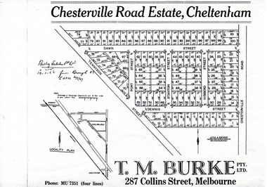 City of Moorabbin Historical Society (Operating the Box Cottage Museum)
Flyer - Chesterville Road Estate, Cheltenham, 1947
... Chesterville Road Estate, Cheltenham - plan of subdivision...Example of the progress of the Municipality of Moorabbin Tennyson Street Port Street Dennis Street Station Street Dawn Street Hubbard Street Chesterville Road Cheltenham real estate auction Chesterville Road Estate, Cheltenham - plan of subdivision Photocopy of advertising flyer for sale of real estate sales - plan of building blocks for sale Flyer Chesterville Road Estate, Cheltenham ...Chesterville Road Estate, consisting of 101 building lots, was sold by private sale in late 1947.Example of the progress of the Municipality of MoorabbinPhotocopy of advertising flyer for sale of real estate sales - plan of building blocks for saleChesterville Road Estate, Cheltenham - plan of subdivisiontennyson street, port street, dennis street, station street, dawn street, hubbard street, chesterville road, cheltenham, real estate, auction -
 Kew Historical Society Inc
Plan - Subdivision Plan, Violet Farm Estate, 1927
... Pru Sanderson, in her groundbreaking ‘City of Kew Urban Conservation Study : Volume 2 - Development History’ (1988), summarised the periods of urban development and subdivisions of land in Kew. The periods that she identified included 1845-1880, 1880-1893, 1893-1921, 1921-1933, 1933-1943, and Post-War Development. ...Like many other subdivisions in Kew and East Kew, older houses (Lots 1 and 13) were often included in the subdivision. ...Like many other subdivisions in Kew and East Kew, older houses (Lots 1 and 13) were often included in the subdivision. ...Pru Sanderson, in her groundbreaking ‘City of Kew Urban Conservation Study : Volume 2 - Development History’ (1988), summarised the periods of urban development and subdivisions of land in Kew. The periods that she identified included 1845-1880, 1880-1893, 1893-1921, 1921-1933, 1933-1943, and Post-War Development. These periods were selected as they represented periods of rapid growth or decline in urban development. An obvious starting point for Sanderson’s groupings involved population growth and the associated economic cycles. These cycles also highlighted urban expansion onto land that was predominantly rural, although in other cases it represented the decline and breakup of large estates. A number of the plans in the Kew Historical Society’s collection can also be found in other collections, such as those of the State Library of Victoria and the Boroondara Library Service. A number are however unique to the collection.The Kew Historical Society collection includes almost 100 subdivision plans pertaining to suburbs of the City of Melbourne. Most of these are of Kew, Kew East or Studley Park, although a smaller number are plans of Camberwell, Deepdene, Balwyn and Hawthorn. It is believed that the majority of the plans were gifted to the Society by persons connected with the real estate firm - J. R. Mathers and McMillan, 136 Cotham Road, Kew. The Plans in the collection are rarely in pristine form, being working plans on which the agent would write notes and record lots sold and the prices of these.The subdivision plans are historically significant examples of the growth of urban Melbourne from the beginning of the 20th Century up until the 1980s. A number of the plans are double-sided and often include a photograph on the reverse. A subdivision plan for nineteen ‘bonny, airy building blocks’ on either side of Violet Grove, Kew East. Violet Grove runs between High Street and Harp Road. Like many other subdivisions in Kew and East Kew, older houses (Lots 1 and 13) were often included in the subdivision. Such houses were in some instances the original properties that were subdivided, or in the case of the Violet Grove subdivision, new houses such as the weatherboard villa on lot 13. This villa is advertised as having a tiled roof, 5 rooms, panelled hall, double doors (Rooms 14 x 12 ft. 6 in. (2) 14 x 12, 12 x 11, 13 x 11). A bricked front verandah, a tiled stove recess and existing sewerage connection added to its saleable potential. Water, electric light and power, and gas were all offered as part of the deal. Violet Grove now has about 35 houses, which indicates that the 19 lots of the subdivision were to be further subdivided by purchasers. [A similar plan is in the Batten & Percy Collection of the State Library of Victoria.]subdivision plans - east kew, violet farm estate, violet grove -- kew (vic.), boorool road -- kew (vic.), harp road -- kew east (vic.) -
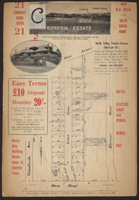
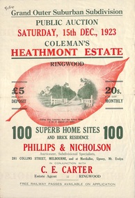 Ringwood and District Historical Society
Flyer, Land Sale Brochure, Coleman's Heathmont Estate, Ringwood, Vic. - 1923
... Bi-fold advertisement for auction sale of residential sites, including photographs, map, and summary of subdivision features and local facilities. Auction date Saturday 15th December, 1923. ...Subdivision includes Bedford Road, Canterbury Road, Alvena Crescent, Leonard Street (later Royal Avenue), and Coleman Street. ...Ringwood and District Historical Society 125A Warrandyte Road Ringwood North melbourne Subdivision includes Bedford Road, Canterbury Road, Alvena Crescent, Leonard Street (later Royal Avenue), and Coleman Street. ...Bi-fold advertisement for auction sale of residential sites, including photographs, map, and summary of subdivision features and local facilities. Auction date Saturday 15th December, 1923. Subsequent auction date Saturday 19th January, 1924, following previous sale stopped on account of rain. Initial newspaper advertisement (publication unknown) dated 16/11/23.Subdivision includes Bedford Road, Canterbury Road, Alvena Crescent, Leonard Street (later Royal Avenue), and Coleman Street. Agent - Phillips & Nicholson, 281 Collins Street Melbourne, (Phone) Central 10907, in conjunction with C.E. Carter, Main Street, Ringwood. Tel. Ringwood 24. -
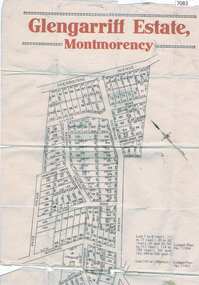 Greensborough Historical Society
Map, Glengarriff Estate Montmorency, 1938c
... Colour photocopy of subdivision map, on two A3 sheets ...Bordered by Sherbourne Avenue, Calrossie Avenue, Montmorency Station and Price Avenue glengarriff estate montmorency sherbourne avenue montmorency calrossie avenue montmorency price avenue montmorency montmorency station Colour photocopy of subdivision map, on two A3 sheets Glengarriff Estate Montmorency Map T. ...Estate Agent's plan of Glengarriff Estate, Montmorency, covering LPs 11334 and 11451. Bordered by Sherbourne Avenue, Calrossie Avenue, Montmorency Station and Price AvenueColour photocopy of subdivision map, on two A3 sheets glengarriff estate montmorency, sherbourne avenue montmorency, calrossie avenue montmorency, price avenue montmorency, montmorency station -
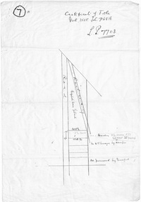 Ringwood and District Historical Society
Document - Subdivision Notes, Certificate of Title - LP7703 Mary Ann Williams, Bedford Road Ringwood, County of Mornington dated 18/4/1912
... Three pages of notes and subdivision sketches on tracing paper....Document Subdivision Notes ...Three pages of notes and subdivision sketches on tracing paper.Mary Ann Williams of Bedford Road Ringwood in the County of Mornington, wife of John Williams of the same place, Gardener, is now the proprietor of and estate in fee simple subject to the encumbrances notified herunder in all that piece of land deliniated and coloured red on the map in the margin, containing 72 acres 3 roods and 30 perches of thereabouts being parts of Crown Portion 16, Parish of Ringwood, County of Mornington, together with a right of carriage way over the road coloured brown on the said map. 18/4/1912. Encumbrances - special railway conditions contained in Crown Grant to Nelson Polak. Transfer to Elizabeth Anne Yelland 10/9/1918 Transfer to Mary M Savage 16/5/1912 (?) Easement - Emma Blood 8/10/1919 (?) Turner - 12/3/1924 18 Greenwood Avenue 3/7/1915 Caveat no.63960 25/8/1924