Showing 1960 items
matching tourists
-
 Port Fairy Historical Society Museum and Archives
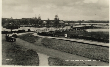
Postcard, Moyne River, Port Fairy
Postcard made for tourists visiting port FairyBlack and white photograph of the road bridge crossing the river Moyne No 12 - Moyne River, Port Fairymoyne bridge, postcard, botanical gardens, cart, car, river, road, gipps street -
 Lakes Entrance Historical Society
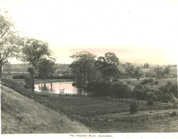
Postcard - Mitchell River Bairnsdale Victoria, 1920 c
One of the series of postcards used in the tourist industryPostcard of scene of Mitchell River with fences in the foreground and in the background bridge and Bairnsdale VictoriaThe Mitchell River Bairnsdalehouses, rivers, topography -
 Warrnambool and District Historical Society Inc.
Booklet - Warrnambool Visitor's Handbooks 1979-2024, Collett, Bain and Gaspar, Printers, 1979-2014
This is a collection of eight Warrnambool Visitor handbooks produced between 1979 and 2014 by the City of Warrnambool Tourist Information Centre. They contain maps of Warrnambool, lists of services, accommodation and tourist attractions as well as many advertisements for local businesses.These handbooks give a useful snapshot of businesses and tourist attractions in Warrnambool for each of the years covered. (1979, 1980, 1986, 1990, 1993, 1994, 1995, 2014)[.1a] A 48 page booklet with white pages and blue printing. The front cover has a coloured photograph of Flagstaff Hill with boats on a man made lake in the foreground looking across Lake Pertobe toward South Warrnambool. [.1b] A coloured bifold brochure. The front cover has a fisherman on a cray-boat holding a crayfish in the lower section. The top quarter has a blue back ground with white printing. The rear cover is red and has small photos of the Hopkins River and the Framlingham Forest. [.2] A 48 page booklet with white pages and black printing. The front cover is white with black writing on the left hand side and a colour photograph of the Loch Ard peacock. The Warrnambool Premier Town stylised logo of seven Norfollk pines above blue waves is in the top right hand corner. There is a blank ink Warrnambool Library stamp underneath the logo. The rear cover has photographs of The Twelve Apostles and the Hopkins Falls and the Premier Town Logo [.3] A 40 page booklet with mainly black printing on white paper. There are three fold out maps of Warrnambool and the surrounding district. The glossy cover has a black background with a colour photograph of the Twelve Apostles taken at sunset. The rear cover has three small of Proudfoot's boathouse on the Hopkins River, Flagstaff Hill, and the main beach area. The front cover has black writing inside to peach coloured rectangles. The inside rear cover has a fold out coloured tour map of Western Victoria. [.4] A 40 page booklet printed on glossy white paper with coloured photographs and black and red printing. The front cover has a photograph of The Twelve Apostles surrounded by a white border. There is red writing in the upper border. There is a sandy coloured writing superimposed across the bottom of the photograph and a Victoria's Shipwreck Coast logo in the bottom right hand corner. [.5] A 44 page booklet printed on white paper with black printing. The cream coloured cover has a pale red rectangle with blue writing on the right hand facing edge and includes two stylised Norfolk pines and with waves underneath. There is is an intersecting blue rectangle with cream printing. [.6] A 48 page booklet printed on white paper with black printing. The cover is brown with a cream vertical strip containing black writing on the right hand side. There is a stylised map from Geelong to Mount Gambier showing the Great Ocean Road across the cover. [.7] A 48 page booklet printed on white paper with black print. The glossy colour cover has a photograph of a Southern Right whale fluke. There is white printing on a the blue background of the sky and sea. The bottom left hand side of the front cover has a Tourism Victoria logo made of jigsaw puzzle pieces. The back cover has a stylised coloured map of The Great Ocean Road located in a white rectangle at the top of the page. Within the rectangle is a small map of Australia locating Victoria and the part of Victoria covered by the map. [.8] A 64 page A5 coloured booklet printed on white pages with black print. The white front cover has black and grey print with a colour photograph of two people holding coffee cups watching four race horses being exercised on the beach and in the water of Lady Bay in the early morning. The bottom right hand corner has a Tourism Victoria logo. The rear cover has a mainly blue back ground with a pink orange and green colour splats contains words advertising the 2015 Fun 4 Kids Festival [.1a] Warrnambool The Heart of Victoria's Great Southwest Visitor's Handbook [.1b] Warrnambool City for all seasons; The Heart of Victoria's Great Southwest [.2] Warrnambool visitor's handbook Warrnambool Premier Town 1979-1982 [.3] Warrnambool Handbook Victoria [.4] Warrnambool The Shipwreck Coast [.5] Welcome to Warrnambool Warrnambool Visitors Handbook 1993-1994 [.6] Welcome to Warrnambool Visitors Handbook 1994-95 Rear cover: Warrnambool Centre of Victoria's Shipwreck Coast on Australia's Great Ocean Road [.7] Warrnambool Shipwreck Coast - Great Ocean Road; You'll love every piece of Victoria; Visitors Handbook [.8] Warrnambool Great Ocean Road Official Visitor Guide; It's a wonderful Warrnambool; You'll love every piece of Victoria visitvictoria.com. Rear Cover Live entertainment.Workshops.Creativity.Action 28 June - 5 July 2015 Australia's Best Children's Festival F4K The ultimate winter school holiday adventure Fun 4 kids festival Warrnambool For more information visit Fun4kids.com.au Warrnambool great Ocean Road Victoriawarrnambool, visitor handbooks, tourist information guides, warrnambool maps -
 Ballarat Tramway Museum
Newspaper, The Courier Ballarat, "New futures for tram shelters", 23/06/1971 12:00:00 AM
Newspaper clipping from The Courier, Ballarat, dated 23/6/1971, titled "New futures for tram shelters" with a subtitle, "Sturt street tram shelters are in demand." Two requests for the use of the tram stop shelter at Grenville St. had been received by the City Council. Ballarat Region Tourist Promotion Association suggested it be developed as a tourist information centre and Ballarat Council of Churches wanted to place a Christmas Crib during the Christmas season. Council decided to allow for one Christmas only and suggested that the Shelter at Lydiard St. be used by the Tourist Association. One of large group of newspaper cuttings from John Bainbridge, 7/4/02. Has cutting date separate from item.grenville st, tram stops, shelters, sturt st -
 Orbost & District Historical Society
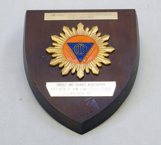
shield, 1984
Air Vice Marshal (Rtd) John Douglas Gordon Lessels, Marshal in charge of disaster relief, was a municipal councillor at Mallacoota where he had a holiday house.A wooden shield with a badge in the centre. Inside an orange circle is " in paratus adversitatem" with a larger CD inside a blue triangle. It has gold coloured decorations . around the circle. There are two small metal plates above and below this badge. On the back is a cut out for hanging.On plate at top : "NATURAL DISASTERS ORGANISATION CANBERRA ACT" On plate below badge : " ORBOST & TOURIST ASSN PRESENTED BY AVM JOHN LESSELS DGNDO 30 NOV 84" shield disaster-organisation orbost-tourism -
 Ballarat Tramway Museum
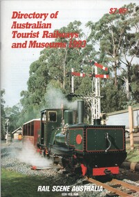
Book, Rail Scene Australia, "Guide to Australian Tourist Railways and Museums 1993", 1993, 1994
.1 - Book - 64 A4 pages - colour covers, titled "Guide to Australian Tourist Railways and Museums 1993", listing all operational railway and tramway museums in Australia at the time. Gives details for each organisation and details of umbrella organisations in each state. Arranged on a State and regional basis. .2 - as above - 100 pages - "Guide to Australian Tourist Railways and Museums 1994". Published by Rail Scene Australia - ARHS NSW and the LRRSAtrams, tramways, railways, tram preservation, museums, arhs -
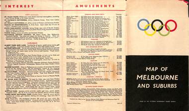 Melbourne Tram Museum
Map, Victorian Government Tourist Bureau, "Map of Melbourne and Suburbs", Jul. 1956
Map - .folded 12 sections full colour titled "Map of Melbourne and Suburbs". Issued at the time of the Melbourne Olympics by the Victorian Government Tourist Bureau. Has an index of Melbourne's suburbs, transport links, Places of Interest, Amusements, Facts of interest about Victoria. Major map shows the rail and tram lines, the detailed map of the CBD shows the buildings or locations referenced in the Tourist Guide to the City. Printed by the Victorian Railways - 2133-56trams, tramways, map, olympics, public transport, melbourne -
 Phillip Island and District Historical Society Inc.
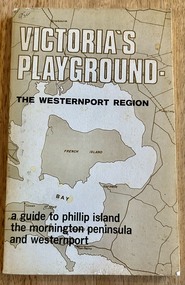
Book, Victoria's Playground The Westernport Region. A guide to Phillip Island, the Mornington Peninsula and Westernport, 1971
Description of Tourist Resorts on Mornington Peninsula and Westernport BayHistoricalBook - soft cover - 117 pages, First edition published 1971 by The Advisory Committee on Recreation and Tourism to The Westernport Regional Planning Authoritymornington peninsula, westernport bay, phillip island -
 Kiewa Valley Historical Society
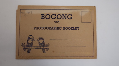
Photographic Booklet - Bogong, Bogong
Photographic Booklets were a common communication for tourists on holiday.Fold out postcard with 9 black and white photos printed one side only. Front has title 'Bogong' / Vic / Photographic Booklet with 2 kookaburras printed on beige cardboard. 3 lines for address. Flap folds into slots on each side. 1957Back: Published by The Valentine Publishing Co. Pty. Ltd. Melbourne, Sydney & Adelaide 'May 1957' penciled on top left corner on cover.bogong, sno cat, mt beauty, tourism -
 Kiewa Valley Historical Society
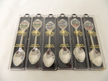
Spoons - Souvenir, Mt Beauty x6
Souvenirs are sold to tourists as a moment of their visit to Mt BeautyMt Beauty is a tourist town6 spoons - 2 of each with a different picture. Silver spoon in a plastic case. The case has a black side with a ring at the top and 2 small pieces that jut out from inside to hold the spoon. The clear front cover fits on and has gold embossing. The stem of the spoon is embossed with lines on the front. At the end there is a circular coloured picture with 'Mt Beauty' below surrounded by embossed decoration.Cover: Map of Auistralia with ASM along the W.A. side / Made in / Australia Spoon: top of handle - Mt Beauty. back of handle - embossed kangaroo. back of stem - 'Swann and Hudson Made in Australiamt beauty. souvenir. silver spoon. tourism. swann and hudson -
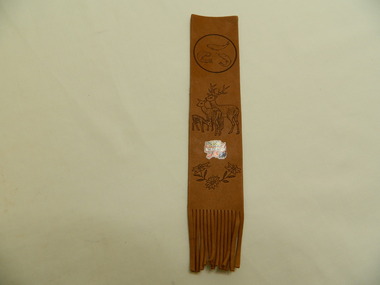 Kiewa Valley Historical Society
Bookmark - Souvenir, Mt Beauty
Bookmarks are sold as souvenirs to tourists to remind them of their holiday. Mt Beauty is a tourist town.Soft brown leather strap with circle around 3 fish at the top, 3 deer in the middle and 3 flowers at the bottom. Frilled at the bottom end. Between the deer and flowers is a coloured picture with 'Mt Beauty' across the middle.Mt Beautysouvenir. mt beauty. bookmark. tourism -
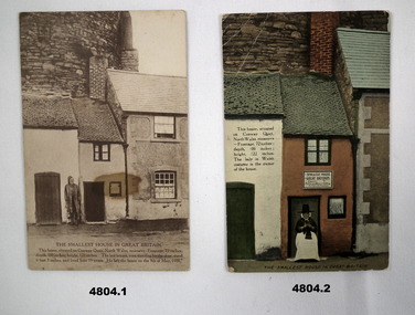 Bendigo Military Museum
Postcard - POSTCARDS - Scenic postcards from Wales, J.Jones et al
WW!, Tourist cards sent home by Joe Stuart.1. Sepia coloured photo of small house in Great Britain, located at Conway Quay, North Wales. The house is 6 feet wide. 2. Colourised picture of smallest house in Great Britain, Conway Quay. There is Lady in National dress, seated at the door doing knitting. 3. Colourised photo of kitchen of above. 4. Colourised photo of bedroom of above. The house size frontage 72 inches. Back to front 100 inches, Height 122 inches.1. On the rear Is addressed to "Dear Susie - Best love Joe". 2. 3. & 4. Nil on rear.wales, small housing -
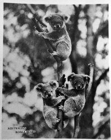 Phillip Island and District Historical Society Inc.
Photograph, Murray Views, Koalas
One of many common photos sold to tourists as souvenirsSmall black & white photo of 3 koalas in a tree.Australian Koala Bearskoalas, postcards, photographs, wildlife - koala -
Tatura Irrigation & Wartime Camps Museum
DVD, The Loveday Internment Camp 1940-1946
Used to inform tourists at an information centre in South Australia.DVD with case. The case back includes printed description of the content of the DVD.loveday internment camps, tourist information -
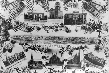 Stawell Historical Society Inc
Photograph, Stawell Public Buildings -- Tourist Type Photos 1902 -- Postcard
Stawell Public Buildings (Tourist Type Photos) 1902stawell -
Clunes Museum
Booklet, F.C. WEICKHARDT, CLUNES' HISTORY, ATTRACTIONS AND SURROUNDS, CIRCA 1975
SHIRE OF TALBOT AND CLUNES OUTLINING CLUNES' HISTORY, ATTRACTIONS AND SURROUNDSA PHOTOCOPIED BOOKLET OF EIGHT PAGES, PRINTED ON BUFF COLOURED PAPER . COMPILED BY MR. F.C. WEICKHARDT FOR THE SHIRE OF TALBOT AND CLUNES OUTLINING CLUNES' HISTORY, ATTRACTIONS AND SURROUNDS (COMPILED 19 OCTOBER 1970 REVISED 1975)non-fictionSHIRE OF TALBOT AND CLUNES OUTLINING CLUNES' HISTORY, ATTRACTIONS AND SURROUNDSlocal history, document, pamphlet, weickhardt -
 Peterborough History Group
Document - Maps, tourist information
Council boundaries, past tourist information, past mapsHistoric town information and mapsPhotocopies, copies of maps, newspaper clippingpeterborough history, peterborough 3270 -
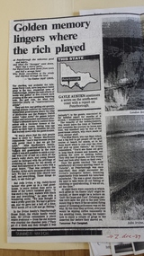
 Ballarat Heritage Services
Souvenir - Postcard Booklet Image, Nucolor Vue, A Souvenir of Beautiful Daylesford, c1948
Daylesford in a tourist town with natural mineral water springsA booklet of colour images depicting 12 scenes of Daylesford, Victoria. The front cover is decorated with an illustration of a dirt road with sign post. Images include: Panorama over Daylesford, from lookout tower Panorama over Lake Daylesford Pioneer Memorial Lookout Tower, Daylesford Near the swimming pool, Lake Daylesford Botanical Gardens, Daylesford Vincent Street, showing Town Hall, Daylesford Vincent Street, Daylesford Glimpse of lovely Jubilee Lake, Daylesford Central Springs, Daylesford Sutton Springs, Daylesford Corner of the beautiful Botanical Gardens, Daylesford Loddon Falls, near Daylesford.daylesford, jubillee lake, wombat hill, vincent street, sutton springs, central springs, loddon springs, pioneer lookout, pioneer memorial lookout, loddon falls, lake daylesford -
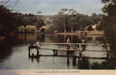 Ballarat Heritage Services
Souvenir - Image from a Postcard Booklet Image, Jubilee Lake, Daylesford, c1945
Daylesford in a tourist town with natural mineral water springs Botanical Gardens, Daylesford Vincent Street, showing Town Hall, Daylesford Vincent Street, Daylesford Glimpse of lovely Jubilee Lake, Daylesford Central Springs, Daylesford Sutton Springs, Daylesford Corner of the beautiful Botanical Gardens, Daylesford Loddon Falls, near Daylesford.daylesford, jubillee lake -
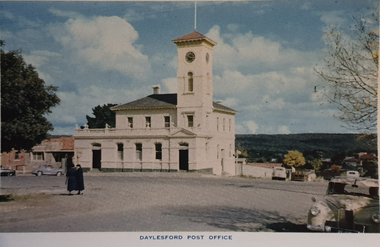 Ballarat Heritage Services
Souvenir - Image from a Postcard Booklet Image, Daylesford Post Office, c1948
Daylesford in a tourist town with natural mineral water springsPhotographic image of the Daylesford Post Office, which features a clock tower.daylesford, daylesford post office, central springs road, victoria street, vincent street -
 Ballarat Heritage Services
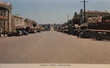
Photograph - Image from a Postcard Booklet Image, Vincent Street Daylesford, c1948
Daylesford in a tourist town with natural mineral water springsPhotographic image of a streetscape of Vincent Street Daylesford from Central Springs Roaddaylesford, central springs road, vincent street, streetscape -
 Ballarat Heritage Services
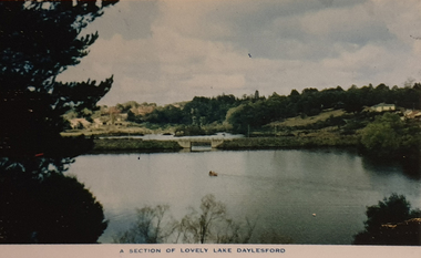
Souvenir - Image from a Postcard Booklet Image, Lake Daylesford, c1948
Daylesford is a tourist towns with natural mineral water springsPhotographic image Lake Daylesford.daylesford, lake daylesford -
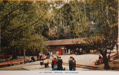
 Ballarat Heritage Services
Souvenir - Image from a Postcard Booklet Image, Central Springs, Daylesford, c1948
Daylesford is a tourist towns with natural mineral water springsCentral Springs, one of many mineral water springs at Daylesford.daylesford, lake daylesford, central springs -
 Stawell Historical Society Inc
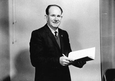
Photograph, Mr Ian R. McCann – Tourist Promotion Officer 1968 -- Portrait
Portrait I.R. McCann – Tourist Promotion Officer 1968stawell -
 Lakes Entrance Historical Society
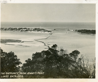
Postcard - The Entrance, 1940c
Originally in a pack of miniature postcards produced for sale to tourists.Black and white small format postcard of the Western end of Bullock Island, Reeves and Entrance Channels, the Entrance and Carpenter Town at the New Works. Taken from Jemmys Point, it shows rock groynes built to channel water flow to the Entrance. Lakes Entrance VictoriaThe Entrance Jemmys Point Lakes Entrance V2 topography, waterways -
Tatura Irrigation & Wartime Camps Museum
Pamphlet, Get Hooked on Tatura
Pamphlets to rpomote Tatura as a great place to visit with golf and bowls, tennis, horse racing and Waranga basin nearby2 pamphlets. Black and white sketches of cars in traffic jam promoting Tatura to visit and relax, on front, Tatura and relax - in red on back. Map of Tatura and list of industries and tourist sitesget hooked on tatura, promoting tatura, tatura, tourism, documents, pamphlets -
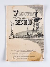 City of Greater Bendigo - Civic Collection
Booklet, J. W. H Publications, 7 Routes. Sightseeing in and around Bendigo, c 1950
A publication promoting visitation and automobile touring around Bendigo and surrounding districts. Suggests seven routes and contains extensive advertising for accommodation, businesses and services within Bendigo and Castlemaine.Thirty two page tourist fold out booklet containing maps and directions for half day and day routes in the district. Booklet also contains advertising promoting Bendigo and District businesses. city of greater bendigo commerce, city of greater bendigo tourism, making a nation exhibition -
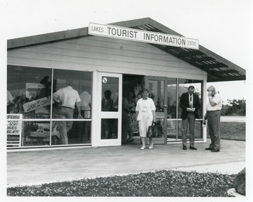 Lakes Entrance Historical Society
Photograph - Information Centre Lakes Entrance, Lakes Post Newspaper, 1993 c
Original centre built with voluntary labour, a Chamber of Commerce initiative. Business opened November 1987, officially opened by Joan Kirner.Black and white photograph of the Lakes Entrance Tourist Information Centre, showing original structure. Councillor Adeline Whelan and two men on forecourt, lots people inside. Lakes Entrance Victoriatourism, public utilities -
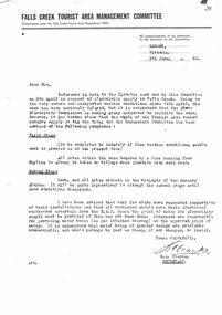 Falls Creek Historical Society
Letter - Electricity Supply Delayed Due To Severe & Unexpected Weather
Bob Hymans Collection Bob (Herman) Hymans (a former member of the Royal Netherlands Navy) was born in Bloemendaal, Holland on 30th September 1922. During World War II he fought against the Japanese in the Dutch East Indies (now Indonesia) and was imprisoned in Changi and on the Burma Railway. After gaining qualifications as a Ski Instructor, Bob arrived in Falls Creek in July 1950. Working as an Instructor and Supervisor at Bogong Lodge, Bob decided his future was in accommodation. He was successful in negotiating an indenture for land from the State Electricity Commission (SEC). It took Bob two years to build his Grand Coeur Chalet but, tragically, it was burned down in August 1961. Bob also built the first Chairlift in Australia. This was a single chairlift and the structure was built from wooden electricity poles. He was constantly full of new ideas and proposals for the village. Bob Hymans died on 7th July 2007. This Collection of documents and letters tells the story of Bob's endeavours to develop Falls Creek into the ski village it is today.This letter is significant because it reflects difficulties encountered in the development of facilities and services at Falls Creek..A letter from the Falls Creek Tourist Area Management Committee explaining reasons for the delay in electricity connections. It also reiterates the requirements of Licensee to ensure that their properties are connected. A new timeline is included.electricity connections falls creek, sec -
Lakes Entrance Historical Society
Book, Paynesville Maritime Museum Inc, Exploring the Gippsland Lakes, 2010
A facsimile reproduction of the 'Tourist's and Sportsman's Guide to the Gippsland Lakes and Surrounding Country' printed c. 1882 for the Lakes Navigation Company. It provided a description of the main ports of call of the boats 'Tanjil', 'Bairnsdale' andtourism, advertising