Showing 671 items
matching tunnellers
-
 Eltham District Historical Society Inc
Photograph, Liz Pidgeon, Heritage Excursion; Maroondah Aqueduct, 3 September 2016, 3 September 2016
Heritage Excursion - Maroondah Aqueduct Walk - Saturday 3rd September The Maroondah Aqueduct was once a major link in Melbourne’s water supply system. It was built between 1886 and 1891 to transfer water from the Watts River near Healesville to the Preston Reservoir. It was 66 km in length, made up of 41 km of open channel, 10 km of tunnel through hills and 15 km of pipeline across stream valleys known as inverted siphons. The section of the aqueduct through the Eltham area has been abandoned since the 1980s but the open channel has largely been retained. A recreational path follows the aqueduct reserve. For our excursion on 3rd September we intend to walk along the section of the aqueduct adjacent to Allendale Road. This is a section not visited on previous excursions and includes the transition from open channel to the inverted siphon across the Diamond Creek valley. Apart from the aqueduct itself the main feature of the walk is the extensive views across Eltham North and Diamond Creek. Along the way we will talk about the history of the aqueduct and the area. This easy walk is about 3 km return and will take 2 to 2.5 hours. It will start at 2pm at the junction of Allendale Road with Godber Road and Zig Zag Road North, officially Diamond Creek, but on the northern boundary of Eltham. (Melway ref.12 B10). Newsletter No., 229, August 2016 Abandoned rusty farm machinery possibly used for tilling the soil - off the Aqueduct trail Born Digitalmaroondah aqueduct, eltham north, activities, eltham district historical society, heritage excursion, aqueduct trail, farm machinery -
 Eltham District Historical Society Inc
Photograph, Liz Pidgeon, Heritage Excursion; Maroondah Aqueduct, 3 September 2016, 3 September 2016
Heritage Excursion - Maroondah Aqueduct Walk - Saturday 3rd September The Maroondah Aqueduct was once a major link in Melbourne’s water supply system. It was built between 1886 and 1891 to transfer water from the Watts River near Healesville to the Preston Reservoir. It was 66 km in length, made up of 41 km of open channel, 10 km of tunnel through hills and 15 km of pipeline across stream valleys known as inverted siphons. The section of the aqueduct through the Eltham area has been abandoned since the 1980s but the open channel has largely been retained. A recreational path follows the aqueduct reserve. For our excursion on 3rd September we intend to walk along the section of the aqueduct adjacent to Allendale Road. This is a section not visited on previous excursions and includes the transition from open channel to the inverted siphon across the Diamond Creek valley. Apart from the aqueduct itself the main feature of the walk is the extensive views across Eltham North and Diamond Creek. Along the way we will talk about the history of the aqueduct and the area. This easy walk is about 3 km return and will take 2 to 2.5 hours. It will start at 2pm at the junction of Allendale Road with Godber Road and Zig Zag Road North, officially Diamond Creek, but on the northern boundary of Eltham. (Melway ref.12 B10). Newsletter No., 229, August 2016 Brick bridge on Parsons road, Eltham North over the aqueduct on the aqueduct trail. Born Digitalmaroondah aqueduct, eltham north, activities, eltham district historical society, heritage excursion, parsons road, bridges, aqueduct trail -
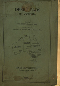 Federation University Historical Collection
Book, Mines Department, Victoria, Deep Leads of Victoria, 1937, 1937
Charcoal green soft covered book of 64 pages. Contents include Ballarat, berry Consols, Canadian Lead, Castlemaine-Daylesford System, Chiltern, Duke of Cornwall Mine, Dyke's Freehold, Frenchman's Lead, Garibaldi Shaft, Glenfine, Guidlford, Hepburn Estate Co., Hepburn Home Paddock, Italian Gully, Henderson's Lead, Langi Logan, Leigh Consols, Sebastopol Plateau; Talbot, Woady Yalloak, A definition of a deep lead, formation of deep leads, water in deep leads, methods of deep lead mining (Tunnelling, Deep sinking, Chiltern method of working, Ballarat method of working), sampling washdirt and gravels, Balmoral, Mt William, Stawell, Moyston, Great Western, Ararat, Raglan, Wimmera Valley, Landsborough, Cardigan, Haddon, Beaufort, Waterloo, Avoca, Lamplough, Caralulup, Ballarat West, Ballarat, Smythesdale, Glenfine, Illabarook, Durham Lead, Morrison's Lead, Bullengarook, Berry-Moolort-Loddon System, Clunes, Creswick, Spring Hill, Bullarook, Castlemaine - Daylesford, Majorca, Carisbrook, Timor, Burnt Creek Tributary, Tarnagulla, Marong, Rheola, Inglewood, Huntly, Coliban, Campaspe, Goulburn Lead System, Ovens Valley System, Mitta Mitts, Kiewa Valley, Tarago, Tanjil, Moondarra, Bogong, Dargo High Plains, glossarymining, deep leads, mines department, squire, leigh consols, chiltern, duke of cornwall mine, dyke's freehold, frenchman's lead, garibaldi shaft, glenfine, guidlford, hepburn estate co., hepburn home paddock, italian gully, henderson's lead, langi logan, sebastopol plateau, talbot, woady yalloak, tunnelling, deep sinking, chiltern method of working, ballarat method of working, sampling washdirt. gravels, balmoral, mt william, stawell, moyston, great western, ararat, raglan, wimmera valley, landsborough, cardigan, haddon, beaufort, waterloo, avoca, lamplough, caralulup, ballarat west, ballarat, smythesdale, illabarook, durham lead, morrison's lead, bullengarook, berry-moolort-loddon system, clunes, creswick, spring hill, bullarook, castlemaine - daylesford, majorca, carisbrook, timor, burnt creek tributary, tarnagulla, marong, rheola, inglewood, huntly, coliban, campaspe, goulburn lead system, ovens valley system, mitta mitta, kiewa valley, tarago, tanjil, moondarra, bogong, dargo high plains -
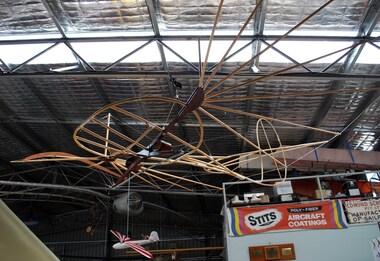 Australian Gliding Museum
Equipment - Glider – Hang Glider Type, 2013 - 2014
Otto Lilienthal (1848-1896) from Berlin, Germany, is widely credited as being the first person to make repeated successful gliding flights. He was known for adopting a thorough scientific approach founded on observations of the flight of birds in relation to the problem of inventing a man carrying heavier than air machine that would fly. He developed and tested bird-like gliders controlled by weight shift by the pilot (a similar method to modern hang gliders). The pilot held on to the glider with his forearms resting in hoops mounted on the main structural beam connecting the wings. The weight shift was achieved by the pilot swinging his trunk and legs. In contrast, the pilot of a modern hang glider is suspended below the glider and, with the use of an A-frame, allows the whole body to be moved around to achieve control. The Lilienthal design apparently had a tendency to pitch down and a tailplane was added to mitigate this problem. Lilienthal flew from hills in the Rhinow region and from a conical hill he built near Berlin. He made over 2000 flights. Importantly, for others seeking to progress manned flight at the time and also for the historical record, reports of Lilienthal’s flights (some with photographs) were published and Lilienthal detailed his experiences and corresponded with other flight pioneers. Lilienthal’s work became well known and influenced Orville and Wilbur Wright in their initial experiments with gliders in 1899 (although in their quest to design and fly an aeroplane they relied on new data created by wind tunnel testing). The replica built by Bruce Hearn is of the 1893 Lilienthal glider. It is very similar to the “Normal-Segalapparat” (Normal Glider) for which patent protection was later granted a few years later. The Lilienthal replica glider is an important addition to the AGM collection as it represents the beginning of successful gliding flight. Hang glider made of wood with wire bracing – yet to be covered with authentic cotton fabric. The glider has a small plate with identification details including name of builder (Bruce Hearn) glider, hang glider, lilienthal, hearn, replica -
 Surrey Hills Historical Society Collection
Work on paper - Vertical file, Box Hill Electorate (State)
1. ‘How to vote Liberal in the Box Hill district’, 2018, Robert Clark (1 page). 2. ‘How to vote for Paul Hamer Labor for Box Hill’, 2018 (1 page). 3. Vote 1 Greens, 2018, Sophia Sun (1page). 4. ‘Paul Hamer Labor for Box Hill’, 2018 (1 page,2 copies) AND Victorian Labor re level crossing removals (1 page). 5. ‘Paul Hamer, MP State member for Box Hill 2019 Budget update’, (1 page, 2 copies). 6. ‘Paul Hamer, MP State member for Box Hill Box Hill Bulletin’, c. 2019 (4 page brochure, 2 copies). 7. ‘Paul Hamer, MP State member for Box Hill Box Hill Bulletin’, Summer 2020/21 (4 page brochure, 2 copies). 8. Paul Hamer, MP State member for Box Hill letter to Mr. & Mrs. M & S Barnett, undated, (1 page). 9. ‘Getting on with the Metro Tunnel Project’, undated (1 page). 10. ‘What next for Surrey Hills ?’, SHNN No. 218, February/March, 2019 (1 page). 11. ‘Local Member’s Report – Robert Clark’, SHNN No. 138, October/November, 2005 (1 page). 12. ‘Who’d be a politician ?’, SHNN No. 150, October/November, 2007 (1 page). -
 The Beechworth Burke Museum
Photograph - Photograph - Reproduction, ca. 1900
This image shows the approach to Beechworth from the south-west via the Newtown Bridge. Numerous early buildings line the road as it bifurcates to become Ford and High Streets on the ridge above Spring Creek and Newtown Falls. The sloping, rocky terrain and water course along the gorge show evidence of the intense mining activity that occurred at the site. The Ovens Gold Rush at Beechworth started when gold was found at Spring Creek in February 1852, prompting an influx of miners from around the world. The population grew over 20,000 by 1857. While the earliest mining at Beechworth was similar to that in other Victorian goldfields like Ballarat and Bendigo, Beechworth is notable for its use of hydraulic sluicing as a major method of removing wash-dirt. Hydraulic sluicing employs high pressure jets of water to blast away large areas of earth and wash it down to be run through a sluice box. Gold gets caught in the sluice and the remaining slurry is washed away. This method of mining is extremely effective but causes significant environmental impacts and damage to waterways. Large water quantities were required for large-scale sluicing, and the long water races and deep tailraces that were constructed in the Beechworth area in the nineteenth century are nonetheless considered feats of engineering. The site in the photograph is associated with the Rocky Mountain Mining Company who constructed an eight hundred meter tunnel under the township between 1876-1880 to reduce water levels at Spring Creek, which had been subject to diversions since the earliest days of alluvial mining. Over four million ounces of gold (115 tones) were found at Beechworth between 1852 and 1868, and the wealth from the gold rushes built Beechworth and the nationally significant buildings that remain standing today.This image shows the early development of the Beechworth township above Spring Creek, where gold was discovered in 1852. Evidence of hydraulic sluicing, a uniquely predominant method at Beechworth, and water-works engineering are present in the landscape. By the 1870s, alluvial gold deposits were depleted and increasingly complex engineering was required so deeper shafts could reach bedrock. This image is significant for understanding changes to the landscape and the evolution of mining methods and engineering practices related to the extensive construction, manipulation and management of water networks. The shift from smaller scale alluvial mining to larger company dominance in the mining industry has implications for understanding wider social, economic, political and industrial changes in the region of Beechworth and within the context of the Victorian Gold Rush more broadly. A black and white rectangular reproduction photograph printed on photographic paper. burke museum, beechworth museum, beechworth, gold fields, gold rush, victorian gold rush, hydraulic sluicing, rocky mountain mining company, spring creek, netwown falls, mining tunnels, water races, tailraces, colonial australia, australian gold rushes, mining technology, beechworth historic district, indigo gold trail, migration, indigo shire, gold mining, gold mining history -
 Federation University Historical Collection
Book - Newsclippings, Folder of Newspaper Cuttings Relating to University of Ballarat and Federation University Australia, 2004 onwards, 2004 onwards
Folder of newsclippings, including: Ballarat Courier 03 November 1999 - Ballarat Sporting Heroes (Shayne Reese, Tony Lockett, Dennis Shaw, Tessa Molloy, Lisa Bruty, Kirst Benoit, Brett Hunter) Ballarat Courier 19 May 2001 - State revenue Office Ballarat Courier 02 MaY 2003 - Brian Howlett Kembla Lines September 2006 - Inside Steel at Port Kembla Weekend Australian 23-4 September 2006 - Adams Forges a Legacy in Steel by Robert Gottliebson - Bluescope Steel, Kirby Adams. Port Kembla Ballarat Courier 14 May 2003 - Alan Webb received Honorary Doctorate Ballarat Courier 07 July 2007 - Exhibition Showcases A Century of Artworks by Dorothy Wickham - outlines an exhibition highlighting 100 years of Art Lectures curated by Clare Gervasoni Ballarat Courier 23 December 2010 - Historical Sites Study Launched - Ballarat Industrial Heritage Wiki launched. Ballarat Courier 21 April 2014 - Unknown Soldier, tunnellers par of project's research: Wartime Connections Ballarat News 14 February 2019 - FedUni VC to speak at leadership forum. (Photo: Helen Bartlett) Ballarat News 10 June 2021 - Taking a closre look at contact tracing by Katie Martin. (Contact tracing during the Covid19 pandemic) Ballarat News 21 October 2021 - Hospital adds temporary Covid-19 triage tent by Edwina Williamsfederation university, university of ballarat, tony lockwood, alfred deakin place, state regional freight links program, nazareth house, ballarat technology park, state revenue office, wendouree parade, deer park bypass, geelong road caravan park, brian howlett, alan webb, honorary doctorate, arthur pickford, mosaics, john pickford, janet holmes a court, mount helen campus history, ballarat techncial art school, tony flude, joseph flude, humanities, nurture the humanities, clunes school of mines, ballarat school of mines 140th anniversary, david battesby, john mcdonald, kath white, catherine laffey, neil trivett, greg simmons, ballarat & district industrial heritage wiki, federation university art collection, ballarat school of mines honor book, clare gervasoni, henry sutton, sutton's music house, john smythe, david caro, david caro obituary, student union, new university name, merger, gippsland, mount helen campus, univesity of ballarat alumni connect, name change, science building, y building, ballarat equine centre, ballarat brewery, ballarat and united breweries, feduni, former ballarat gaol, ballarat gaol basement cells, federation college, sam henson, janet cowles, alexandra tascas, helen bartlett, graduation, pandemic, covid19, covid-19, corona virus -
 Eltham District Historical Society Inc
Slide, Maroondah Aqueduct, Research, Victoria, 22 Mar. 1981
An inspection tour of the Maroondah Aqueduct was undertaken by the Shire of Eltham Historical Society on Sunday, March 22nd, 1981, commening where the aqueduct crosses Main Rd., Research, just below Eltham College. The Maroondah Aqueduct was part of Melbourne’s water supply system. It carried water over the 66 km from the Maroondah Reservoir on the Watts River at Healesville to the Preston Reservoir. Of this length, 41 km were open channel, 10 km, tunnel through hills and 15 km in 14 inverted siphons across stream valleys. The route of the aqueduct is north of Tarrawarra and Yarra Glen, along the Yarra escarpment south of Christmas Hills and crossing Watsons Creek into the present Shire of Eltham near Henley Rd. The eastern part of the route lies entirely within the former boundaries of the shire. The aqueduct passes south of Kangaroo Ground to Research and crosses the Diamond Creek by siphon at Allendale Rd., Eltham North. It then extends to Reservoir via St. Helena, Greensborough North and Bundoora. Water first flowed through the aqueduct in February 1891 when it was fed by a diversion weir on the Watts River. Records of the building of the aqueduct indicate that it was a significant construction achievement. The present Maroondah Reservoir was completed in 1927 and the aqueduct was enlarged at that time to take increased flows. About 1971 the section of the aqueduct through and north of Research was replaced by a large pipe and that section of the channel is now unused. The channel has remained largely intact (unlike sections at Greensborough and Bundoora where long lengths of the disused aqueduct have been demolished or filled in). The M.M.B.W. relinquished control of the disused aqueduct reserve which is crown land and the Shire of Eltham took control of this section of the reserve as a linear park. The Maroondah Aqueduct is considered to be an important historic structure, not just to the local area but to the metropolitan area generally. It is considered important to preserve substantially intact long lengths of the disused aqueduct, together with its bridges and other associated structures. 35 mm colour positive transparency (1 of 5) Mount - Agfachrome Agfa CS System black 8 dotsactivities, heritage excursion, maroondah aqueduct, research (vic.), shire of eltham historical society -
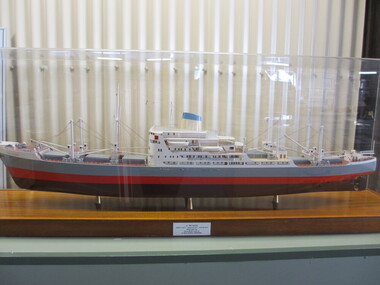 Seaworks Maritime Museum
Shipbuilders model, Tri Ellis
Model ship was presented to the Melbourne Maritime Museum by the British Phosphate Commissioners. Built as Tri-Ellis (1958-74), Tryphena (1974-78), Man Tat (1978-80), 1980 broken up. DWT 13,756 SPEED 14 KNOTS.AT 112RPM. BOILERS LARKSON TRIMBLETUBE. FUEL CONSUMPTION 7 TPD. GENERATORS W.H.ALLEN - 4CYL.2SA290/470. 480B.H.P.320L.W.-220V 333RPM DAILY CONS - 1.5 TONS. EMERGENCY GEN R & H. 40 K.N. -220V. REFRIGERATING MACH: J & G HALL LTD. SUPERSTRUCTURE: FORECASTLE 62'..2 DECKS RIVETED AND WELDED. CARGO BATTONS NOT FITTED. 9 BULKHEADS. RISE OF FLOOR 6".WATER BALLAST 3,296 TONS INCLUDING TUNNEL TANKS 1,341 TONS. 'TWEEN- DECKS FORWARD 274 TONS. REFRIGERATED CARGO INSTALLATION - 6 HOLDS - 55.2',52',54',59.5',43' ,53'. GRAIN CAPACITY :621,640 CU. FT. BALE CAPACITY : 573,810 CU. FT. INSULATED CAPACITY : 5,050 CU.FT. 6 STEEL HATCHWAYS (27',30',30'* 30') (30'* 27.75') (27', 24' * 28' ). 12 WINCHES...DERRICKS 1 (25), 2 (10), 10 (5). MACHINERY: OIL 2SA 7CY.C20 * 1400MM EXHAUST 470MM. 6500 BHP. FUEL BUNKERS: 2135 TONS HIGH VISCOCITY FUEL. The main engine was an opposed piston type Harland & Wolff 6-620/ 1870 6 for the number of cylinders.. 620 for the cylinder bore and 1870 for the combined strokes of the main exhaust pistons in each cylinder. This engine was based no a Burmeister and Wain design but H & W gave these engines their own type designation. Sailed on board its maiden voyage to Australia via Casablanca Morocco where she collected her first load of phosphate. We sailed to Geelong via the Suez canal and the Port of Aden (Yemen) and Freemantle. The first load of phosphate was unloaded at Corio Bay (geelong) Formerly part of the collection of Melbourne shipping company, Howard Smith Ltd. Ship builder's model of the cargo ship Tri-Ellis IMO 5368196 - Body of moulded polyurethane painted in red, black and grey, the deck painted in red, with detailed fittings, machinery, rigging and superstructure, raised on a wooden base. Original ship built Clyde 1958, 11,761 gross tonnes, 531.5' x 68' x 31' (162.0 x 20.73 x 9.45m)plaque at foot of model "MV TRI ELLIS/ LENGTH B.P. 486'-3"- BREADTH MLD 68'0" - DEPTH MLD 40'6"/ TONNAGE GROSS 11,760/ Built by HARLAND & WOLFF LTD/ For BRITISH PHOSPHATE COMMISSIONERS" On model "TRI-ELLIS" painted black -
 Eltham District Historical Society Inc
Photograph, 35 Ingrams Road, Research, Eltham Heritage Tour, 24 May 1992, 24/05/1992
ELTHAM HERITAGE TOUR The Society excursion on 24th May 1992 was arranged by David Bick, leader of the team carrying out the Shire's heritage study. David selected a number of sites or buildings identified in the study, some of them lesser known components of the Shire's heritage. The tour commenced at the Eltham Shire Office at 10.00 am. Travel was by private car and mini-bus with stops at about twelve locations for commentary by David.It included a short walk in Hurstbridge and lunch at Kinglake. Highlights of the tour included: - 10 am Leave from Shire Offices - 3 Important Trees - A Physical Link to Eltham's First Settlers - Toorak Mansion Gates - A Surviving Farm House - An Intact Circa 1900 Main Street - First Settlers - Gold Miners, and Timber-getters - An Early Hotel - A Pioneering Homestead - Changing Eltham Shire - 20th Century - 4 pm Afternoon Tea and Finish Tour Extract from ELTHAM CULTURAL HERITAGE TOUR (Newsletter No. 85, July 1992, by Bettina Woodburn) "On a right-angle turning of the Eltham Road is Wellers Pub, a Cobb & Co. coaching stop on the way to distant gold-fields and places north of the Yarra River. The Hotel dates from the 1870's. Daily distances for a bullock team was eight miles, horses could do double that distance. We turned into Cassells Road and on the corner of Ingrams Road we admired an elaborate Edwardian villa, 1900 style. The Aqueduct conveying Melbourne's water supply was a communication line and a technological advance in 1891. It has been enlarged and re-faced and no longer used here but piped underground. Proclaimed a linear park it has reverted to crown land, controlled by local Council. Maroondah Dam was constructed in. 1920 to replace the original weir and at that time: the Aqueduct - as established into the landscape - with bridges and tunnels and pine trees were used to stop rubbish polluting the water."Record of the Society's history and activities and highlighting various aspects of the Heritage Study undertaken by David Bick used to create the future heritage overlay for the Shire of Eltham and later Nillumbik Shire.Roll of 35mm colour negative film, 4 stripsKodak Gold 100 5095shire of eltham historical society, activities, heritage tour, ingrams road, research (vic.) -
 Bendigo Historical Society Inc.
Photograph - Historical Society Field Trip to the Springs at Sedgwick, Abt 2009
The Phil Wilkin Collection contains a series of 11 Items. The related items can be found by clicking on the reference link below. The following history of the Young family and their descendants who lived at the Springs is provided by Phil Wilkin. His Great Grandparents were Frances Young and August Wirth. Phil has also provided notes on the Wilkin Family and some history of the gold mining in Sedgwick. Frances Young's parents Joseph and Margaret Young owned the property called "The Old Place, Preston Vale or Wellington Flat" at Sedgwick near the Springs. Joseph Young owned and Managed the Standard Brewery which was located at Campbells Creek during the late 1800’s early 1900’s. Joseph and Margaret are buried in the Harcourt cemetery. In 1880 August Wirth lived at Mosquito Creek (Lake Eppalock, Victoria) when he married Frances Young. In 1902 they moved to part of Joseph Young's property. They milked cows and sold cattle for a living. One of their children Charles Wirth (Phil Wilkin's Grandfather) bought the land in 1935 after his parents had died. Charles Wirth was a councillor and also was president of the Shire of Strathfieldsaye. The "Old Place" was part of the property owned by members of the family. The old house at the Springs was burnt out by bushfire in January 1944 and much of the stonework was later vandalized by campers. The original Coliban Water Works were designed in 1863 by the Irish engineer Joseph Brady. The system included 70 kilometres of open water channels, aqueducts, syphons and tunnels to carry water (by gravity) from the Coliban River at Malmsbury, north to Castlemaine and Bendigo. Sedgwick is a locality in Central Victoria, Australia. It is located in the City of Greater Bendigo. Facilities include a public hall that opened in 1958 and CFA Rural fire station. It was named Upper Emu Creek until 1901 when it was renamed as Sedgwick after British geologist Adam Sedgwick.Twenty nine photos taken on a field trip by the Bendigo Historical Society to "The Springs" on the main Coliban water channel from Malmsbury to the Sandhurst Reservoir in Bendigo. The water race descends through a concrete chute, and continues sharply around the contour of the hills. Once it descended into a syphon across the gully. The are 182 photos in this series and can be found at 8683.1 to 8683.11. The series also includes photos of the surrounding farming land and the remains of an old house. There are also some notes on the pioneers of the district.history, bendigo, coliban water, joseph brady, irrigation, the springs, sedgwick -
 Bendigo Historical Society Inc.
Photograph - Historical Society Field Trip to the Springs at Sedgwick, Abt 2009
The Phil Wilkin Collection contains a series of 11 Items. The related items can be found by clicking on the reference link below. The following history of the Young family and their descendants who lived at the Springs is provided by Phil Wilkin. His Great Grandparents were Frances Young and August Wirth. Phil has also provided notes on the Wilkin Family and some history of the gold mining in Sedgwick. Frances Young's parents Joseph and Margaret Young owned the property called "The Old Place, Preston Vale or Wellington Flat" at Sedgwick near the Springs. Joseph Young owned and Managed the Standard Brewery which was located at Campbells Creek during the late 1800’s early 1900’s. Joseph and Margaret are buried in the Harcourt cemetery. In 1880 August Wirth lived at Mosquito Creek (Lake Eppalock, Victoria) when he married Frances Young. In 1902 they moved to part of Joseph Young's property. They milked cows and sold cattle for a living. One of their children Charles Wirth (Phil Wilkin's Grandfather) bought the land in 1935 after his parents had died. Charles Wirth was a councillor and also was president of the Shire of Strathfieldsaye. The "Old Place" was part of the property owned by members of the family. The old house at the Springs was burnt out by bushfire in January 1944 and much of the stonework was later vandalized by campers. The original Coliban Water Works were designed in 1863 by the Irish engineer Joseph Brady. The system included 70 kilometres of open water channels, aqueducts, syphons and tunnels to carry water (by gravity) from the Coliban River at Malmsbury, north to Castlemaine and Bendigo. Sedgwick is a locality in Central Victoria, Australia. It is located in the City of Greater Bendigo. Facilities include a public hall that opened in 1958 and CFA Rural fire station. It was named Upper Emu Creek until 1901 when it was renamed as Sedgwick after British geologist Adam Sedgwick.Twenty five photos taken on a field trip by the Bendigo Historical Society to "The Springs" on the main Coliban water channel from Malmsbury to the Sandhurst Reservoir in Bendigo. The water race descends through a concrete chute, and continues sharply around the contour of the hills. Once it descended into a syphon across the gully. The are 182 photos in this series and can be found at 8683.1 to 8683.11. The series also includes photos of the surrounding farming land and the remains of an old house. There are also some notes on the pioneers of the district.history, bendigo, coliban water, joseph brady, irrigation, the springs, sedgwick -
 Bendigo Historical Society Inc.
Photograph - Historical Society Field Trip to the Springs at Sedgwick, Abt 2009
The Phil Wilkin Collection contains a series of 11 Items. The related items can be found by clicking on the reference link below. The following history of the Young family and their descendants who lived at the Springs is provided by Phil Wilkin. His Great Grandparents were Frances Young and August Wirth. Phil has also provided notes on the Wilkin Family and some history of the gold mining in Sedgwick. Frances Young's parents Joseph and Margaret Young owned the property called "The Old Place, Preston Vale or Wellington Flat" at Sedgwick near the Springs. Joseph Young owned and Managed the Standard Brewery which was located at Campbells Creek during the late 1800’s early 1900’s. Joseph and Margaret are buried in the Harcourt cemetery. In 1880 August Wirth lived at Mosquito Creek (Lake Eppalock, Victoria) when he married Frances Young. In 1902 they moved to part of Joseph Young's property. They milked cows and sold cattle for a living. One of their children Charles Wirth (Phil Wilkin's Grandfather) bought the land in 1935 after his parents had died. Charles Wirth was a councillor and also was president of the Shire of Strathfieldsaye. The "Old Place" was part of the property owned by members of the family. The old house at the Springs was burnt out by bushfire in January 1944 and much of the stonework was later vandalized by campers. The original Coliban Water Works were designed in 1863 by the Irish engineer Joseph Brady. The system included 70 kilometres of open water channels, aqueducts, syphons and tunnels to carry water (by gravity) from the Coliban River at Malmsbury, north to Castlemaine and Bendigo. Sedgwick is a locality in Central Victoria, Australia. It is located in the City of Greater Bendigo. Facilities include a public hall that opened in 1958 and CFA Rural fire station. It was named Upper Emu Creek until 1901 when it was renamed as Sedgwick after British geologist Adam Sedgwick.Twenty six photos taken on a field trip by the Bendigo Historical Society to "The Springs" on the main Coliban water channel from Malmsbury to the Sandhurst Reservoir in Bendigo. The water race descends through a concrete chute, and continues sharply around the contour of the hills. Once it descended into a syphon across the gully. The are 182 photos in this series and can be found at 8683.1 to 8683.11. The series also includes photos of the surrounding farming land and the remains of an old house. There are also some notes on the pioneers of the district.history, bendigo, coliban water, joseph brady, irrigation, the springs, sedgwick -
 Bendigo Historical Society Inc.
Photograph - Historical Society Field Trip to the Springs at Sedgwick, Abt 2009
The Phil Wilkin Collection contains a series of 11 Items. The related items can be found by clicking on the reference link below. The following history of the Young family and their descendants who lived at the Springs is provided by Phil Wilkin. His Great Grandparents were Frances Young and August Wirth. Phil has also provided notes on the Wilkin Family and some history of the gold mining in Sedgwick. Frances Young's parents Joseph and Margaret Young owned the property called "The Old Place, Preston Vale or Wellington Flat" at Sedgwick near the Springs. Joseph Young owned and Managed the Standard Brewery which was located at Campbells Creek during the late 1800’s early 1900’s. Joseph and Margaret are buried in the Harcourt cemetery. In 1880 August Wirth lived at Mosquito Creek (Lake Eppalock, Victoria) when he married Frances Young. In 1902 they moved to part of Joseph Young's property. They milked cows and sold cattle for a living. One of their children Charles Wirth (Phil Wilkin's Grandfather) bought the land in 1935 after his parents had died. Charles Wirth was a councillor and also was president of the Shire of Strathfieldsaye. The "Old Place" was part of the property owned by members of the family. The old house at the Springs was burnt out by bushfire in January 1944 and much of the stonework was later vandalized by campers. The original Coliban Water Works were designed in 1863 by the Irish engineer Joseph Brady. The system included 70 kilometres of open water channels, aqueducts, syphons and tunnels to carry water (by gravity) from the Coliban River at Malmsbury, north to Castlemaine and Bendigo. Sedgwick is a locality in Central Victoria, Australia. It is located in the City of Greater Bendigo. Facilities include a public hall that opened in 1958 and CFA Rural fire station. It was named Upper Emu Creek until 1901 when it was renamed as Sedgwick after British geologist Adam Sedgwick.Twenty five photos taken on a field trip by the Bendigo Historical Society to "The Springs" on the main Coliban water channel from Malmsbury to the Sandhurst Reservoir in Bendigo. The water race descends through a concrete chute, and continues sharply around the contour of the hills. Once it descended into a syphon across the gully. The are 182 photos in this series and can be found at 8683.1 to 8683.11. The series also includes photos of the surrounding farming land and the remains of an old house. There are also some notes on the pioneers of the district.history, bendigo, coliban water, joseph brady, irrigation, the springs, sedgwick -
 Bendigo Historical Society Inc.
Photograph - The Young and Wirth Families at Preston Vale, near the Springs Sedgwick, 1880s-1900s
The Phil Wilkin Collection contains a series of 11 Items. The related items can be found by clicking on the reference link below. The following history of the Young family and their descendants who lived at the Springs is provided by Phil Wilkin. His Great Grandparents were Frances Young and August Wirth. Phil has also provided notes on the Wilkin Family and some history of the gold mining in Sedgwick. Frances Young's parents Joseph and Margaret Young owned the property called "The Old Place, Preston Vale or Wellington Flat" at Sedgwick near the Springs. Joseph Young owned and Managed the Standard Brewery which was located at Campbells Creek during the late 1800’s early 1900’s. Joseph and Margaret are buried in the Harcourt cemetery. In 1880 August Wirth lived at Mosquito Creek (Lake Eppalock, Victoria) when he married Frances Young. In 1902 they moved to part of Joseph Young's property. They milked cows and sold cattle for a living. One of their children Charles Wirth (Phil Wilkin's Grandfather) bought the land in 1935 after his parents had died. Charles Wirth was a councillor and also was president of the Shire of Strathfieldsaye. The "Old Place" was part of the property owned by members of the family. The old house at the Springs was burnt out by bushfire in January 1944 and much of the stonework was later vandalized by campers. The original Coliban Water Works were designed in 1863 by the Irish engineer Joseph Brady. The system included 70 kilometres of open water channels, aqueducts, syphons and tunnels to carry water (by gravity) from the Coliban River at Malmsbury, north to Castlemaine and Bendigo. Sedgwick is a locality in Central Victoria, Australia. It is located in the City of Greater Bendigo. Facilities include a public hall that opened in 1958 and CFA Rural fire station. It was named Upper Emu Creek until 1901 when it was renamed as Sedgwick after British geologist Adam Sedgwick.Thirty Four Photos of Joseph Young's property near "The Springs" on the main Coliban water channel from Malmsbury to the Sandhurst Reservoir in Bendigo. This item contains family history of Joeph's descendant Charles Wirth, who was a councillor for the Shire of Strathfieldsaye. The water race descends through a concrete chute, and continues sharply around the contour of the hills. Once it descended into a syphon across the gully. The are 182 photos in this series and can be found at 8683.1 to 8683.11. The series also includes photos of the surrounding farming land and the remains of an old house. There are also some notes on the pioneers of the district.history, bendigo, coliban water, joseph brady, irrigation, the springs, sedgwick, charles wirth, preston vale, joseph and margaret young, standard brewery campbells creek harcourt, phil wilkin collection -
 Bendigo Historical Society Inc.
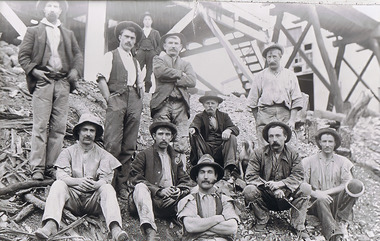
Photograph - The Sedgwick Gold Mine, abt 1909
The Phil Wilkin Collection contains a series of 11 Items. The related items can be found by clicking on the reference link below. The following history of the Young family and their descendants who lived at the Springs is provided by Phil Wilkin. His Great Grandparents were Frances Young and August Wirth. Phil has also provided notes on the Wilkin Family and some history of the gold mining in Sedgwick. Frances Young's parents Joseph and Margaret Young owned the property called "The Old Place, Preston Vale or Wellington Flat" at Sedgwick near the Springs. Joseph Young owned and Managed the Standard Brewery which was located at Campbells Creek during the slate 1800’s early 1900’s. Joseph and Margaret are buried in the Harcourt cemetery. In 1880 August Wirth lived at Mosquito Creek (Lake Eppalock, Victoria) when he married Frances Young. In 1902 they moved to part of Joseph Young's property. They milked cows and sold cattle for a living. One of their children Charles Wirth (Phil Wilkin's Grandfather) bought the land in 1935 after his parents had died. Charles Wirth was a councillor and also was president of the Shire of Strathfieldsaye. The "Old Place" was part of the property owned by members of the family. The old house at the Springs was burnt out by bushfire in January 1944 and much of the stonework was later vandalized by campers. The original Coliban Water Works were designed in 1863 by the Irish engineer Joseph Brady. The system included 70 kilometres of open water channels, aqueducts, syphons and tunnels to carry water (by gravity) from the Coliban River at Malmsbury, north to Castlemaine and Bendigo. Sedgwick is a locality in Central Victoria, Australia. It is located in the City of Greater Bendigo. Facilities include a public hall that opened in 1958 and CFA Rural fire station. It was named Upper Emu Creek until 1901 when it was renamed as Sedgwick after British geologist Adam Sedgwick.Four photos of the miners and information on the Sedgwick Gold Mine. There are 182 photos in this series and can be found at 8683.1 to 8683.11. The series also includes photos of the surrounding farming land and the remains of an old house. There are also some notes on the pioneers of the district.history, bendigo, coliban water, joseph brady, irrigation, the springs, sedgwick, phil wilkin collection, sedgwick gold mine -
 Bendigo Historical Society Inc.
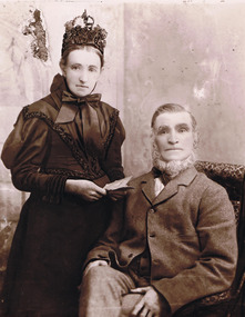
Photograph - Joseph and Margaret Young from Preston Vale (near The Springs) Sedgwick, 1800s-1900s
The Phil Wilkin Collection contains a series of 11 Items. The related items can be found by clicking on the reference link below. The following history of the Young family and their descendants who lived at the Springs is provided by Phil Wilkin. His Great Grandparents were Frances Young and August Wirth. Phil has also provided notes on the Wilkin Family and some history of the gold mining in Sedgwick. Frances Young's parents Joseph and Margaret Young owned the property called "The Old Place, Preston Vale or Wellington Flat" at Sedgwick near the Springs. Joseph Young owned and Managed the Standard Brewery which was located at Campbells Creek during the late 1800’s early 1900’s. Joseph and Margaret are buried in the Harcourt cemetery. In 1880 August Wirth lived at Mosquito Creek (Lake Eppalock, Victoria) when he married Frances Young. In 1902 they moved to part of Joseph Young's property. They milked cows and sold cattle for a living. One of their children Charles Wirth (Phil Wilkin's Grandfather) bought the land in 1935 after his parents had died. Charles Wirth was a councillor and also was president of the Shire of Strathfieldsaye. The "Old Place" was part of the property owned by members of the family. The old house at the Springs was burnt out by bushfire in January 1944 and much of the stonework was later vandalized by campers. The original Coliban Water Works were designed in 1863 by the Irish engineer Joseph Brady. The system included 70 kilometres of open water channels, aqueducts, syphons and tunnels to carry water (by gravity) from the Coliban River at Malmsbury, north to Castlemaine and Bendigo. Sedgwick is a locality in Central Victoria, Australia. It is located in the City of Greater Bendigo. Facilities include a public hall that opened in 1958 and CFA Rural fire station. It was named Upper Emu Creek until 1901 when it was renamed as Sedgwick after British geologist Adam Sedgwick.12 photos and historical document of Joseph and Margaret Young. There are 182 photos in this series and can be found at 8683.1 to 8683.11. The series also includes photos of the surrounding farming land and the remains of an old house. There are also some notes on the pioneers of the district.history, bendigo, coliban water, joseph brady, irrigation, the springs, sedgwick, phil wilkin collection, standard brewery campbells creek, joeseph and margaret young -
 Bendigo Historical Society Inc.
Photograph - The Wilkin Family of Sedgwick, 1800s-1900s
The Phil Wilkin Collection contains a series of 11 Items. The related items can be found by clicking on the reference link below. The following history of the Young family and their descendants who lived at the Springs is provided by Phil Wilkin. His Great Grandparents were Frances Young and August Wirth. Phil has also provided notes on the Wilkin Family and some history of the gold mining in Sedgwick. Frances Young's parents Joseph and Margaret Young owned the property called "The Old Place, Preston Vale or Wellington Flat" at Sedgwick near the Springs. Joseph Young owned and Managed the Standard Brewery which was located at Campbells Creek during the late 1800’s early 1900’s. Joseph and Margaret are buried in the Harcourt cemetery. In 1880 August Wirth lived at Mosquito Creek (Lake Eppalock, Victoria) when he married Frances Young. In 1902 they moved to part of Joseph Young's property. They milked cows and sold cattle for a living. One of their children Charles Wirth (Phil Wilkin's Grandfather) bought the land in 1935 after his parents had died. Charles Wirth was a councillor and also was president of the Shire of Strathfieldsaye. The "Old Place" was part of the property owned by members of the family. The old house at the Springs was burnt out by bushfire in January 1944 and much of the stonework was later vandalized by campers. The original Coliban Water Works were designed in 1863 by the Irish engineer Joseph Brady. The system included 70 kilometres of open water channels, aqueducts, syphons and tunnels to carry water (by gravity) from the Coliban River at Malmsbury, north to Castlemaine and Bendigo. Sedgwick is a locality in Central Victoria, Australia. It is located in the City of Greater Bendigo. Facilities include a public hall that opened in 1958 and CFA Rural fire station. It was named Upper Emu Creek until 1901 when it was renamed as Sedgwick after British geologist Adam Sedgwick.17 photos and historical document of the Wilkin Family associated with the Springs near Sedgwick. There are 182 photos in this series and can be found at 8683.1 to 8683.11. The series also includes photos of the surrounding farming land and the remains of an old house. There are also some notes on the pioneers of the district.history, bendigo, coliban water, joseph brady, irrigation, the springs, sedgwick, phil wilkin collection, standard brewery campbells creek, joeseph and margaret young, wilkin family -
 Bendigo Historical Society Inc.
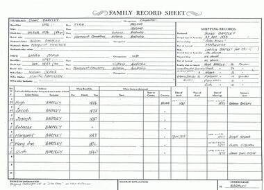
Photograph - The Wilkin Family of Sedgwick - Isaac and Letitia Barcley, 1800s-1900s
The Phil Wilkin Collection contains a series of 11 Items. The related items can be found by clicking on the reference link below. The following history of the Young family and their descendants who lived at the Springs is provided by Phil Wilkin. His Great Grandparents were Frances Young and August Wirth. Phil has also provided notes on the Wilkin Family and some history of the gold mining in Sedgwick. Frances Young's parents Joseph and Margaret Young owned the property called "The Old Place, Preston Vale or Wellington Flat" at Sedgwick near the Springs. Joseph Young owned and Managed the Standard Brewery which was located at Campbells Creek during the late 1800’s early 1900’s. Joseph and Margaret are buried in the Harcourt cemetery. In 1880 August Wirth lived at Mosquito Creek (Lake Eppalock, Victoria) when he married Frances Young. In 1902 they moved to part of Joseph Young's property. They milked cows and sold cattle for a living. One of their children Charles Wirth (Phil Wilkin's Grandfather) bought the land in 1935 after his parents had died. Charles Wirth was a councillor and also was president of the Shire of Strathfieldsaye. The "Old Place" was part of the property owned by members of the family. The old house at the Springs was burnt out by bushfire in January 1944 and much of the stonework was later vandalized by campers. The original Coliban Water Works were designed in 1863 by the Irish engineer Joseph Brady. The system included 70 kilometres of open water channels, aqueducts, syphons and tunnels to carry water (by gravity) from the Coliban River at Malmsbury, north to Castlemaine and Bendigo. Sedgwick is a locality in Central Victoria, Australia. It is located in the City of Greater Bendigo. Facilities include a public hall that opened in 1958 and CFA Rural fire station. It was named Upper Emu Creek until 1901 when it was renamed as Sedgwick after British geologist Adam Sedgwick.Seven historical documents of Isacc and Letitia Barcley who were associated with the Wilkin Family and also with the Springs near Sedgwick. There are 182 photos in this series and can be found at 8683.1 to 8683.11. The series also includes photos of the surrounding farming land and the remains of an old house. There are also some notes on the pioneers of the district.history, bendigo, coliban water, joseph brady, irrigation, the springs, sedgwick, phil wilkin collection, joeseph and margaret young, letitia and isacc barclay -
Bendigo Historical Society Inc.
Photograph - Phil Wilkin Collection - The Springs at Sedgwick 11 Items
The Phil Wilkin Collection contains a series of 11 Items. The related items can be found by clicking on the reference link below. The following history of the Young family and their descendants who lived at the Springs is provided by Phil Wilkin. His Great Grandparents were Frances Young and August Wirth. Phil has also provided notes on the Wilkin Family and some history of the gold mining in Sedgwick. Frances Young's parents Joseph and Margaret Young owned the property called "The Old Place, Preston Vale or Wellington Flat" at Sedgwick near the Springs. Joseph Young owned and Managed the Standard Brewery which was located at Campbells Creek during the late 1800’s early 1900’s. Joseph and Margaret are buried in the Harcourt cemetery. In 1880 August Wirth lived at Mosquito Creek (Lake Eppalock, Victoria) when he married Frances Young. In 1902 they moved to part of Joseph Young's property. They milked cows and sold cattle for a living. One of their children Charles Wirth (Phil Wilkin's Grandfather) bought the land in 1935 after his parents had died. Charles Wirth was a councillor and also was president of the Shire of Strathfieldsaye. The "Old Place" was part of the property owned by members of the family. The old house at the Springs was burnt out by bushfire in January 1944 and much of the stonework was later vandalized by campers. The original Coliban Water Works were designed in 1863 by the Irish engineer Joseph Brady. The system included 70 kilometres of open water channels, aqueducts, syphons and tunnels to carry water (by gravity) from the Coliban River at Malmsbury, north to Castlemaine and Bendigo. Sedgwick is a locality in Central Victoria, Australia. It is located in the City of Greater Bendigo. Facilities include a public hall that opened in 1958 and CFA Rural fire station. It was named Upper Emu Creek until 1901 when it was renamed as Sedgwick after British geologist Adam Sedgwick.The Phil Wilkin Collection contains a series of eleven Items about the Young family and their descendants who lived at the Springs and is provided by Phil Wilkin. His Great Grandparents were Frances Young and August Wirth. Phil has also provided notes on the Wilkin Family and some history of the gold mining in Sedgwick. The are 182 photos in this series and can be found at 8683.1 to 8683.11. The series also includes photos of the surrounding farming land and the remains of an old house. There are also some notes on the pioneers of the district.history, bendigo, coliban water, joseph brady, irrigation, the springs, sedgwick -
Bendigo Historical Society Inc.
Photograph - AUSTIN COLLECTION: Central Deborah Gold Mine Lift Shaft
Central Deborah Gold Mine history: At its peak, Central Deborah Gold Mine reached a depth of 412 metres. It has 17 separate levels and 15 kilometres of drives and cross cuts (tunnels). The Central Deborah was very much a hands-on mine and the conditions that the miners worked in would be considered shocking by today's standards – being lowered underground in a cage with only two sides, often working ankle to knee deep in water, filling up to 32 ore trucks a shift by hand which were then pushed a mile or more along rails in the drives, working by carbide lamp, breathing in the fumes and rock dust and communication by bells. Geez, they were ironmen. However, at the time working conditions were considered to be among the best on the goldfields at Central Deborah, after all it was one of the only mines that had hot showers. Following Central Deborah Gold Mine's closure, the Bendigo skyline began to noticeably change. Obvious remnants of mining such as poppet heads, engine rooms, service quarters, battery houses and chimneys were steadily disappearing. After intense lobbying by the local community, the Bendigo City Council purchased the still very much intact Central Deborah Gold Mine in 1970 for a mere $6,000 to ensure that a vital link to Bendigo's historic golden past was maintained. The Bendigo Trust was then formed to oversee the operations of the Central Deborah Gold Mine, which led to the surface of the mine being opened to the public in 1971. Initially the surface was open for just 12 hours a week and as the demand for viewing a part of Bendigo's history increased, so did the opening hours. In 1974 the mine was gazetted as a Public Historical Purposes Reserve and attracted such visitors as H.R.H Prince Charles. By far the greatest shortcoming at this stage was that no one could view the underground workings, as these had become flooded. After what could only be described as a monumental effort by everyone involved, Level 2 of the mine was officially opened to the public by the Premier of Victoria, the Honourable John Cain, on 20 June 1986, which brought to fruition a long standing dream.Black and white photograph, looking from bottom of lift shaft towards the surface; light visible at top of shaft. Lift cables and safety mesh on sides of shaft. gold mining, central deborah gold mine, ray beer, mine manager -
Bendigo Historical Society Inc.
Photograph - AUSTIN COLLECTION: Central Deborah Gold Mine, Possibly 1990's
Central Deborah Gold Mine history: At its peak, Central Deborah Gold Mine reached a depth of 412 metres. It has 17 separate levels and 15 kilometres of drives and cross cuts (tunnels). The Central Deborah was very much a hands-on mine and the conditions that the miners worked in would be considered shocking by today's standards – being lowered underground in a cage with only two sides, often working ankle to knee deep in water, filling up to 32 ore trucks a shift by hand which were then pushed a mile or more along rails in the drives, working by carbide lamp, breathing in the fumes and rock dust and communication by bells. Geez, they were ironmen. However, at the time working conditions were considered to be among the best on the goldfields at Central Deborah, after all it was one of the only mines that had hot showers. Following Central Deborah Gold Mine's closure, the Bendigo skyline began to noticeably change. Obvious remnants of mining such as poppet heads, engine rooms, service quarters, battery houses and chimneys were steadily disappearing. After intense lobbying by the local community, the Bendigo City Council purchased the still very much intact Central Deborah Gold Mine in 1970 for a mere $6,000 to ensure that a vital link to Bendigo's historic golden past was maintained. The Bendigo Trust was then formed to oversee the operations of the Central Deborah Gold Mine, which led to the surface of the mine being opened to the public in 1971. Initially the surface was open for just 12 hours a week and as the demand for viewing a part of Bendigo's history increased, so did the opening hours. In 1974 the mine was gazetted as a Public Historical Purposes Reserve and attracted such visitors as H.R.H Prince Charles. By far the greatest shortcoming at this stage was that no one could view the underground workings, as these had become flooded. After what could only be described as a monumental effort by everyone involved, Level 2 of the mine was officially opened to the public by the Premier of Victoria, the Honourable John Cain, on 20 June 1986, which brought to fruition a long standing dream.Black and white photograph. Two men with hard hats and lights, inspecting quartz outcrop on wall of drive at Central Deborah Gold Mine.gold mining, central deborah gold mine, ray beer, mine manager -
Bendigo Historical Society Inc.
Photograph - AUSTIN COLLECTION: Operating rock drill, Central Deborah Gold Mine, Possibly 1990's
Central Deborah Gold Mine history: At its peak, Central Deborah Gold Mine reached a depth of 412 metres. It has 17 separate levels and 15 kilometres of drives and cross cuts (tunnels). The Central Deborah was very much a hands-on mine and the conditions that the miners worked in would be considered shocking by today's standards – being lowered underground in a cage with only two sides, often working ankle to knee deep in water, filling up to 32 ore trucks a shift by hand which were then pushed a mile or more along rails in the drives, working by carbide lamp, breathing in the fumes and rock dust and communication by bells. Geez, they were ironmen. However, at the time working conditions were considered to be among the best on the goldfields at Central Deborah, after all it was one of the only mines that had hot showers. Following Central Deborah Gold Mine's closure, the Bendigo skyline began to noticeably change. Obvious remnants of mining such as poppet heads, engine rooms, service quarters, battery houses and chimneys were steadily disappearing. After intense lobbying by the local community, the Bendigo City Council purchased the still very much intact Central Deborah Gold Mine in 1970 for a mere $6,000 to ensure that a vital link to Bendigo's historic golden past was maintained. The Bendigo Trust was then formed to oversee the operations of the Central Deborah Gold Mine, which led to the surface of the mine being opened to the public in 1971. Initially the surface was open for just 12 hours a week and as the demand for viewing a part of Bendigo's history increased, so did the opening hours. In 1974 the mine was gazetted as a Public Historical Purposes Reserve and attracted such visitors as H.R.H Prince Charles. By far the greatest shortcoming at this stage was that no one could view the underground workings, as these had become flooded. After what could only be described as a monumental effort by everyone involved, Level 2 of the mine was officially opened to the public by the Premier of Victoria, the Honourable John Cain, on 20 June 1986, which brought to fruition a long standing dream.Black and white photograph. Two men with hard hats and lights standing in front of underground rock surface at Central Deborah Gold Mine. Man on left hand side of image is operating a small rock drill. Man on right hand side is observing the procedure. gold mining, central deborah gold mine, rock drill, underground -
 Bendigo Historical Society Inc.
Document - LISTS OF ITEMS AUCTIONED AT BENDIGO MINES
Typed copies of catalogues of items to be auctioned at the following mines: South Red, White and Blue 12th April 1938 Central Blue 28th October, 1941 at 11 a.m South Virginia Extended (found inside Central Blue catalogue) Big Blue 21st November, 1939 at 10.30 a.m Golden Transverse Bendigo 3rd September 1941Yandoit Co 19th April 1939 Chapman's Gold Mine Chewton 8th February 1939 Ross Creek Extended G.M. Coy 18th August 1938 Ross Creek Extended G.M.Coy Ross Creek Mines Account Mines Dept Pitfield Plains, Glenfine South Shaft Adelong Dredge and leases 10th February 1943 Bright Valley Dredge 9,10th February 1943 Exchequer Extended North Chewton 18th October, 1939 Talbot Alluvials Norbury's No. 2 shaft 5th May 1941 Gordon Gold Mine Inglewood 30th April 1940 Postg Office Hill Mine Chewton 7th February 1940 Carlisle & Whittaker Plant Buninyong Rand Yandoit Mine North Chewton 19th October 1939 Spring Gully Mine Chewton 14th Decembert 1938 Eureka Central Chewton 26th February 1941The Golod Mine Clunes 15th March 1941 Guildford Plateau 20th Novemer 1940 New Long Tunnel Walhalla 12th February 1941 Napoleon BML 28th October 1941 Alfords Battery Hercules No. 1 Mine 12th February 1942 Ramrod Gold Mine Bendigo 19th March 1942 Bendigo Amalgamated Goldfields Limited 10th and 11th August 1938 Virginia South Extended 1st June 1938 -
 Kew Historical Society Inc
Album - Photographs of heritage sites in Victoria, Eva Grant, 1964-66
Eva Grant was a member of the Kew Historical Society. Three albums in the collection were created by her, this one, the third created between 1964 and 1966. They were donated to the Society by her daughter in 2010. Each of the albums includes photographs and newspaper cuttings collected on her travels to historic places in South East Australia in the 1950s and 1960s. Particular structures photographed in this album include: Barnawatha (Vic.) - The Hermitage | Beveridge (Vic.) - Stone cottage where Ned Kelly was born. | Brighton - St Andrew’s Church graveyard. | Chiltern (Vic.) - lake view [missing] | Cowes (Vic.) - ‘Broadwater’ [originally home of Henty-Wilson family], demolished 1965; Bell of the Speke wreck; Edward’s tree. | Euroa (Vic.) - Habbies Howe | Fairfield (Vic.) - Dight’s Falls; John Dight. | Fernshawe (Vic.) - Queen Mary tree. | Jolimont (Vic.) - Old railway tunnel linking the first Government House (1964); Sign identifying location of first Government House. | Kew (Vic.) - Cairn at Dight’s Falls; Canoe tree, Bowyer Avenue. | Kyneton - De Grave’s Flour Mill - “C”. | Maldon (Vic.) - Chinese oven; Macarthur’s House; Maldon’s oldest resident; Chinese graves x 2; [Beehive Chimney]. | Marysville (Vic.) - Centenary cairn | Mitcham (Vic.), Mud brick house x 2, Deep Creek Road. | Melbourne (Vic.) - St Paul’s Cathedral [renovation] (1964); Wreckers at Damman’s Corner, cnr Bourke and Collins Streets (1964); Princess Gate project x 2 (1964); Colonial Storekeeper’s building on cnr King and Bourke Streets (1966); Early observatory 1861-3; the Honey Memorial. | Mt Oberon (Vic.) - [obsolete] radio telephone dish. | Seymour (Vic.) - Habres (sic) House x 3.| Swan Hill (Vic.) - Major Mitchell’s Cairn (12/1964); Headstone of Andrew Beverage AM (12/1964). | Templestowe (Vic.) - Finn’s Hotel. | Thornton (Vic.) - Eildon Station. | Werribee (Vic.) - Chirnside Memorial [Presbyterian] Church; gaslight beside church | Location unknown, but possibly Swan Hill - Brick house; Wooden bullock dray. | Location unknown - Headstone of John Furlonge 1835.Important record of significant heritage properties in Victoria, many of which have since been demolished.30 page spirex bound drawing book including photographs and newspaper articles of historic buildings in Victoria. The front cover has a picture of a steam boat. The cover is encased in plastic. A number items in the album are annotated with written commentary by Eva Grant who compiled the album. Annotations and transcriptions by Eva Grant on most imageseva grant, photograph albums, heritage places - victoria