Showing 558 items matching "victoria: the garden state"
-
 Ballarat Tramway Museum
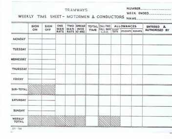
Document - Form/s, State Electricity Commission of Victoria (SECV), "SEC Weekly Time Sheet", 1960's
Demonstrates method of calculating pay for SEC Motormen and Conductors and how the hours were tallied.Pre-printed sheets used for motorman and conductor and management staff to calculate pays based on actual hours work with allowances, various rates etc. Form No. 571 - 700 and titled "SEC Weekly Time Sheet". Record revised and image added 31/10/2013.trams, tramways, employee time sheets, ballarat, bendigo, secv, payroll -
 Kew Historical Society Inc
Plan, Melbourne & Metropolitan Board of Works : Borough of Kew : Detail Plan No.1576, 1904
The Melbourne and Metropolitan Board of Works (MMBW) plans were produced from the 1890s to the 1950s. They were crucial to the design and development of Melbourne's sewerage and drainage system. The plans, at a scale of 40 feet to 1 inch (1:480), provide a detailed historical record of Melbourne streetscapes and environmental features. Each plan covers one or two street blocks (roughly six streets), showing details of buildings, including garden layouts and ownership boundaries, and features such as laneways, drains, bridges, parks, municipal boundaries and other prominent landmarks as they existed at the time each plan was produced. (Source: State Library of Victoria)This plan forms part of a large group of MMBW plans and maps that was donated to the Society by the Mr Poulter, City Engineer of the City of Kew in 1989. Within this collection, thirty-five hand-coloured plans, backed with linen, are of statewide significance as they include annotations that provide details of construction materials used in buildings in the first decade of the 20th century as well as additional information about land ownership and usage. The copies in the Public Record Office Victoria and the State Library of Victoria are monochrome versions which do not denote building materials so that the maps in this collection are invaluable and unique tools for researchers and heritage consultants. A number of the plans are not held in the collection of the State Library of Victoria so they have the additional attribute of rarity.Original survey plan, issued by the MMBW to a contractor with responsibility for constructing sewers in the area identified on the plan within the Borough of Kew. The plan was at some stage hand-coloured, possibly by the contractor, but more likely by officers working in the Engineering Department of the Borough and later Town, then City of Kew. The hand-coloured sections of buildings on the plan were used to denote masonry or brick constructions (pink), weatherboard constructions (yellow), and public buildings (grey). Development in the 20th century has irreparably altered that part of Kew represented in this plan. In the block bounded by Cotham Road, Charles Street, Wellington Street and Gellibrand; just one house standing in 1903 remains. This block included two of the most historic houses in Kew: ‘Ordsall’ (later ‘Southesk’) and ‘Madford’ (previously ‘Elm Lodge’). Ordsall was the home of the second chairman of Kew, John Halfey. It contained some of the most significant interior murals in Kew, created for Halfey by artists working for Cullen & Co. It was demolished in 1960 to make way for the Kew Civic Centre. Elm Lodge had been built for William Siddeley in ca. 1864. Arthur Septimus King purchased it in 1874. The lower paddocks of Madford were sold in 1905 by his wife to the Borough of Kew and, after landscaping by George and Thomas Pockett, opened as the Alexandra Gardens in 1908. Elm Lodge/Madford was in 1922 to become St. Anthony’s Home for Little Children before its subsequent demolition in the 1980s.melbourne and metropolitan board of works, detail plans, maps - borough of kew, mmbw 1576, cartography -
 Kew Historical Society Inc
Plan, Borough of Kew Detail Plan No.1577, 1904
The Melbourne and Metropolitan Board of Works (MMBW) plans were produced from the 1890s to the 1950s. They were crucial to the design and development of Melbourne's sewerage and drainage system. The plans, at a scale of 40 feet to 1 inch (1:480), provide a detailed historical record of Melbourne streetscapes and environmental features. Each plan covers one or two street blocks (roughly six streets), showing details of buildings, including garden layouts and ownership boundaries, and features such as laneways, drains, bridges, parks, municipal boundaries and other prominent landmarks as they existed at the time each plan was produced. (Source: State Library of Victoria)This plan forms part of a large group of MMBW plans and maps that was donated to the Society by the Mr Poulter, City Engineer of the City of Kew in 1989. Within this collection, thirty-five hand-coloured plans, backed with linen, are of statewide significance as they include annotations that provide details of construction materials used in buildings in the first decade of the 20th century as well as additional information about land ownership and usage. The copies in the Public Record Office Victoria and the State Library of Victoria are monochrome versions which do not denote building materials so that the maps in this collection are invaluable and unique tools for researchers and heritage consultants. A number of the plans are not held in the collection of the State Library of Victoria so they have the additional attribute of rarity.Original survey plan, issued by the MMBW to a contractor with responsibility for constructing sewers in the area identified on the plan within the Borough of Kew. The plan was at some stage hand-coloured, possibly by the contractor, but more likely by officers working in the Engineering Department of the Borough and later Town, then City of Kew. The hand-coloured sections of buildings on the plan were used to denote masonry or brick constructions (pink), weatherboard constructions (yellow), and public buildings (grey). MMBW Plan No.1577 includes some of the most significant houses in Kew: Herbert Henty’s ‘Roxeth’ (now part of Trinity Grammar), ‘Butleigh Wooton’, ‘Bokara’ and ‘Harrow’. It also includes the streets that have since changed their names. That part of College Parade linked to Glenferrie Road is now named College Place, College Parade now extends further north, and Charles Street did not yet reach Barkers Road. Roxeth is one of a number of Henty houses in Kew. Herbert Henty made his home here and was elected a member of Kew Municipal Council in 1864 and mayor in 1868-69. Walter Henry Serle, of Harrow served in the First World War. He was awarded the Military Medal ‘’For conspicuous bravery and devotion to duty. On 29th September near BELLICOURT he showed the greatest bravery and determination when his platoon was attacked by enemy bombing parties. It was due largely to his personal efforts that all the attacks were repulsed. Until wounded, his utter disregard of personal safety and boldness in dealing with the attacks were the means of saving the situation and were an inspiring example to his men.’melbourne and metropolitan board of works, detail plans, maps - borough of kew, mmbw 1577, cartography -
 Kew Historical Society Inc
Plan, Melbourne & Metropolitan Board of Works : Borough of Kew : Detail Plan No.1578, 1904
The Melbourne and Metropolitan Board of Works (MMBW) plans were produced from the 1890s to the 1950s. They were crucial to the design and development of Melbourne's sewerage and drainage system. The plans, at a scale of 40 feet to 1 inch (1:480), provide a detailed historical record of Melbourne streetscapes and environmental features. Each plan covers one or two street blocks (roughly six streets), showing details of buildings, including garden layouts and ownership boundaries, and features such as laneways, drains, bridges, parks, municipal boundaries and other prominent landmarks as they existed at the time each plan was produced. (Source: State Library of Victoria). This plan forms part of a large group of MMBW plans and maps that was donated to the Society by the Mr Poulter, City Engineer of the City of Kew in 1989. Within this collection, thirty-five hand-coloured plans, backed with linen, are of statewide significance as they include annotations that provide details of construction materials used in buildings in the first decade of the 20th century as well as additional information about land ownership and usage. The copies in the Public Record Office Victoria and the State Library of Victoria are monochrome versions which do not denote building materials so that the maps in this collection are invaluable and unique tools for researchers and heritage consultants. A number of the plans are not held in the collection of the State Library of Victoria so they have the additional attribute of rarity.Original survey plan, issued by the MMBW to a contractor with responsibility for constructing sewers in the area identified on the plan within the Borough of Kew. The plan was at some stage hand-coloured, possibly by the contractor, but more likely by officers working in the Engineering Department of the Borough and later Town, then City of Kew. The hand-coloured sections of buildings on the plan were used to denote masonry or brick constructions (pink), weatherboard constructions (yellow), and public buildings (grey). MMBW Plan No.1578 is significant in that it defines the extent of two private schools: Xavier College and Kew High School (now part of Trinity Grammar) by 1904. In relation to the latter, the plan clarifies which buildings the High School operated from behind the mansion ‘Molina’. Established in 1902, Trinity Grammar was to later lease and subsequently buy Molina (now ‘Merritt House’) and ‘Elsinore’ (now ‘Roberts House’). Xavier College had been established in 1872. This 1904 plan delineates the West Wing and the Great Hall (built in 1890).melbourne and metropolitan board of works, detail plans, maps - borough of kew, mmbw 1578, cartography -
 Kew Historical Society Inc
Plan, Melbourne & Metropolitan Board of Works. Borough of Kew Detail Plan No.1579, 1904
The Melbourne and Metropolitan Board of Works (MMBW) plans were produced from the 1890s to the 1950s. They were crucial to the design and development of Melbourne's sewerage and drainage system. The plans, at a scale of 40 feet to 1 inch (1:480), provide a detailed historical record of Melbourne streetscapes and environmental features. Each plan covers one or two street blocks (roughly six streets), showing details of buildings, including garden layouts and ownership boundaries, and features such as laneways, drains, bridges, parks, municipal boundaries and other prominent landmarks as they existed at the time each plan was produced. (Source: State Library of Victoria). This plan forms part of a large group of MMBW plans and maps that was donated to the Society by the Mr Poulter, City Engineer of the City of Kew in 1989. Within this collection, thirty-five hand-coloured plans, backed with linen, are of statewide significance as they include annotations that provide details of construction materials used in buildings in the first decade of the 20th century as well as additional information about land ownership and usage. The copies in the Public Record Office Victoria and the State Library of Victoria are monochrome versions which do not denote building materials so that the maps in this collection are invaluable and unique tools for researchers and heritage consultants. A number of the plans are not held in the collection of the State Library of Victoria so they have the additional attribute of rarity.Original survey plan, issued by the MMBW to a contractor with responsibility for constructing sewers in the area identified on the plan within the Borough of Kew. The plan was at some stage hand-coloured, possibly by the contractor, but more likely by officers working in the Engineering Department of the Borough and later Town, then City of Kew. The hand-coloured sections of buildings on the plan were used to denote masonry or brick constructions (pink), weatherboard constructions (yellow), and public buildings (grey). While MMBW Plan No.1579 does not include many buildings, those that it does show are significant to Kew’s history. These include the ‘Kew [Railway] Station’ in Denmark Street and the ‘Recreation Hall’ and rear courts off Wellington Street. The plan shows the outline of the Recreation Hall, constructed in 1880, at the rear of which is listed a bowling green, two tennis courts, a ‘skittle alley’ and a pavilion. When the Hall was first built, the Kew Cricket Club occupied an adjacent ground, however in 1885 this was acquired by the State Government as the future location of the Kew Railway Station. The Plan also shows a single oval at Xavier College. This oval was completed in 1883. One of the current ovals conforms to this oval’s original shape and position in the school grounds.melbourne and metropolitan board of works, detail plans, maps - borough of kew, mmbw 1579, cartography -
 Kew Historical Society Inc
Plan, Melbourne and Metropolitan Board of Works, Borough of Kew : Detail Plan No.1580, 1904
The Melbourne and Metropolitan Board of Works (MMBW) plans were produced from the 1890s to the 1950s. They were crucial to the design and development of Melbourne's sewerage and drainage system. The plans, at a scale of 40 feet to 1 inch (1:480), provide a detailed historical record of Melbourne streetscapes and environmental features. Each plan covers one or two street blocks (roughly six streets), showing details of buildings, including garden layouts and ownership boundaries, and features such as laneways, drains, bridges, parks, municipal boundaries and other prominent landmarks as they existed at the time each plan was produced. (Source: State Library of Victoria)This plan forms part of a large group of MMBW plans and maps that was donated to the Society by the Mr Poulter, City Engineer of the City of Kew in 1989. Within this collection, thirty-five hand-coloured plans, backed with linen, are of statewide significance as they include annotations that provide details of construction materials used in buildings in the first decade of the 20th century as well as additional information about land ownership and usage. The copies in the Public Record Office Victoria and the State Library of Victoria are monochrome versions which do not denote building materials so that the maps in this collection are invaluable and unique tools for researchers and heritage consultants. A number of the plans are not held in the collection of the State Library of Victoria so they have the additional attribute of rarity.Original survey plan, issued by the MMBW to a contractor with responsibility for constructing sewers in the area identified on the plan within the Borough of Kew. The plan was at some stage hand-coloured, possibly by the contractor, but more likely by officers working in the Engineering Department of the Borough and later Town, then City of Kew. The hand-coloured sections of buildings on the plan were used to denote masonry or brick constructions (pink), weatherboard constructions (yellow), and public buildings (grey). The area represented in this detail plan has undergone significant change during the 20th century. The widening of High Street in the 1930s and 1950s involved the shops on the south side of High Street being demolished and later rebuilt to fit the widened street. Another significant loss was the mansion ‘Drayton’ fronting Wellington Street, owned at this stage by Susannah Fenton. Her family name would later to be given to Fenton Way, which was to be built over the grounds of the house following its demolition. The plan of the garden is particularly interesting, containing a batten dome fronting Wellington Street, an ornamental pond, a fountain and a brick and glass conservatory. The notes by the plumbing contractor on this plan are particularly detailed. Pink borders delineate the ownership of the varying parcels of land. Some of the better known owners listed include the real estate agent Cr. Henry de Castres Kellett (bt) and John Padbury, the funeral director. This particular plan provides a clear view of the configuration of the Kew Junction in 1903 and the commercial buildings that surrounded it.melbourne and metropolitan board of works, detail plans, maps - borough of kew, mmbw 1580, cartography -
 Kew Historical Society Inc
Plan, Melbourne & Metropolitan Board of Works : Borough of Kew : Detail Plan No.1581, 1904
The Melbourne and Metropolitan Board of Works (MMBW) plans were produced from the 1890s to the 1950s. They were crucial to the design and development of Melbourne's sewerage and drainage system. The plans, at a scale of 40 feet to 1 inch (1:480), provide a detailed historical record of Melbourne streetscapes and environmental features. Each plan covers one or two street blocks (roughly six streets), showing details of buildings, including garden layouts and ownership boundaries, and features such as laneways, drains, bridges, parks, municipal boundaries and other prominent landmarks as they existed at the time each plan was produced. (Source: State Library of Victoria)This plan forms part of a large group of MMBW plans and maps that was donated to the Society by the Mr Poulter, City Engineer of the City of Kew in 1989. Within this collection, thirty-five hand-coloured plans, backed with linen, are of statewide significance as they include annotations that provide details of construction materials used in buildings in the first decade of the 20th century as well as additional information about land ownership and usage. The copies in the Public Record Office Victoria and the State Library of Victoria are monochrome versions which do not denote building materials so that the maps in this collection are invaluable and unique tools for researchers and heritage consultants. A number of the plans are not held in the collection of the State Library of Victoria so they have the additional attribute of rarity.Original survey plan, issued by the MMBW to a contractor with responsibility for constructing sewers in the area identified on the plan within the Borough of Kew. The plan was at some stage hand-coloured, possibly by the contractor, but more likely by officers working in the Engineering Department of the Borough and later Town, then City of Kew. The hand-coloured sections of buildings on the plan were used to denote masonry or brick constructions (pink), weatherboard constructions (yellow), and public buildings (grey). The streets and built structures in this plan were surveyed in 1903 and released to contractors in 1904. In addition to the designation of building types by colour, the plan includes detailed descriptions of land use and ownership. While many buildings remain from this period, a number of the buildings represented have been demolished including the original Kew Town Hall, and the Congregational and Roman Catholic churches in Walpole Street. While the mansion ‘Illapa’ in Princess Street is still extant – now part of ‘Rylands’ – the neighbouring mansion ‘Elsmere’ was demolished some decades ago. Rivalling Illapa and Elsmere in size were two mansions in Walpole Street, one named on the plan as ‘Gnarlbine’. Over time, Kew Junction and the south side of High Street have been reconfigured and widened, so that the commercial buildings on the corner of Princess and High Street no longer exist. A surprising feature of this part of central Kew to the northwest of Kew Junction is the amount of vacant land. In a number of cases, this land is noted by the contractor as used for vegetable gardens.melbourne and metropolitan board of works, detail plans, maps - borough of kew, mmbw 1581, cartography -
 Kew Historical Society Inc
Plan, Melbourne & Metropolitan Board of Works : Borough of Kew : Detail Plan No.1582, 1904
The Melbourne and Metropolitan Board of Works (MMBW) plans were produced from the 1890s to the 1950s. They were crucial to the design and development of Melbourne's sewerage and drainage system. The plans, at a scale of 40 feet to 1 inch (1:480), provide a detailed historical record of Melbourne streetscapes and environmental features. Each plan covers one or two street blocks (roughly six streets), showing details of buildings, including garden layouts and ownership boundaries, and features such as laneways, drains, bridges, parks, municipal boundaries and other prominent landmarks as they existed at the time each plan was produced. (Source: State Library of Victoria)This plan forms part of a large group of MMBW plans and maps that was donated to the Society by the Mr Poulter, City Engineer of the City of Kew in 1989. Within this collection, thirty-five hand-coloured plans, backed with linen, are of statewide significance as they include annotations that provide details of construction materials used in buildings in the first decade of the 20th century as well as additional information about land ownership and usage. The copies in the Public Record Office Victoria and the State Library of Victoria are monochrome versions which do not denote building materials so that the maps in this collection are invaluable and unique tools for researchers and heritage consultants. A number of the plans are not held in the collection of the State Library of Victoria so they have the additional attribute of rarity.Original survey plan, issued by the MMBW to a contractor with responsibility for constructing sewers in the area identified on the plan within the Borough of Kew. The plan was at some stage hand-coloured, possibly by the contractor, but more likely by officers working in the Engineering Department of the Borough and later Town, then City of Kew. The hand-coloured sections of buildings on the plan were used to denote masonry or brick constructions (pink), weatherboard constructions (yellow), and public buildings (grey). Public buildings, coloured grey on the Plan 1582 include the police station and post office, churches and schools. The earliest church school, Common School No.356 was located at the rear of the Congregational Church in Peel Street. It was constructed in 1859. The first buildings of Kew Primary School No.1075 on the other side of Peel Street were constructed in 1871. The school in 1903 only occupied a small fraction of its current site. In 1903, where the rear playground is now located, were two weatherboard and one brick villa. Trinity Grammar School was founded in 1902 and opened in the Parish Hall at the rear of Holy Trinity Anglican Church. It was not to move to its current site until 1906. The outline of the building housing the Kew Fire Brigade in the centre of the north side of Walton Street is shown but not named on the plan. Further down Pakington Street stood the two-storey Italianate mansion ‘Overton’. The home of Stanford Chapman, it was to be featured in the Imperial Institute series of bromide photographs of Victoria, Vol. 1: Homes and scenery. It was later to become a boarding house before it was later demolished.melbourne and metropolitan board of works, detail plans, maps - borough of kew, mmbw 1582, cartography -
 Kew Historical Society Inc
Plan, Melbourne & Metropolitan Board of Works : Borough of Kew : Detail Plan No.1585, 1904
The Melbourne and Metropolitan Board of Works (MMBW) plans were produced from the 1890s to the 1950s. They were crucial to the design and development of Melbourne's sewerage and drainage system. The plans, at a scale of 40 feet to 1 inch (1:480), provide a detailed historical record of Melbourne streetscapes and environmental features. Each plan covers one or two street blocks (roughly six streets), showing details of buildings, including garden layouts and ownership boundaries, and features such as laneways, drains, bridges, parks, municipal boundaries and other prominent landmarks as they existed at the time each plan was produced. (Source: State Library of Victoria)This plan forms part of a large group of MMBW plans and maps that was donated to the Society by the Mr Poulter, City Engineer of the City of Kew in 1989. Within this collection, thirty-five hand-coloured plans, backed with linen, are of statewide significance as they include annotations that provide details of construction materials used in buildings in the first decade of the 20th century as well as additional information about land ownership and usage. The copies in the Public Record Office Victoria and the State Library of Victoria are monochrome versions which do not denote building materials so that the maps in this collection are invaluable and unique tools for researchers and heritage consultants. A number of the plans are not held in the collection of the State Library of Victoria so they have the additional attribute of rarity.Original survey plan, issued by the MMBW to a contractor with responsibility for constructing sewers in the area identified on the plan within the Borough of Kew. The plan was at some stage hand-coloured, possibly by the contractor, but more likely by officers working in the Engineering Department of the Borough and later Town, then City of Kew. The hand-coloured sections of buildings on the plan were used to denote masonry or brick constructions (pink), weatherboard constructions (yellow), and public buildings (grey). This plan, which covers parts of High Street, Pakington Street and Derby Street is dominated by two historic Kew mansions: ‘Konetta’ and ‘Ramornie’. Ramornie was constructed in 1890 for James Maitland Campbell, three times Mayor of Kew. Sold in 1940, it became a boarding house known as ‘The Towers’. Now a private residence again, it has only one of its three balconies remaining. The location of the missing two balconies can be seen on the plan. In 1903, the grounds of Ramornie included a large tennis court fronting Pakington Street. The rear of the property is shown as extending to Cobden Street. One of Kew’s oldest hotels, the Prospect Hill Hotel on the corner of High and Cobden Street was established in 1858. The outline of the hotel shown on the plan represents the second building on the site. During the 19th century it was often used for electoral meetings. The Prospect Hill Hotel was to be redeveloped again in 1928, by the local architect Robert McIntyre. Since the 1980s, the hotel has been a live music venue, the home of the Melbourne Jazz Club, a restaurant and a liquor outlet.melbourne and metropolitan board of works, detail plans, maps - borough of kew, mmbw 1585, cartography -
 Kew Historical Society Inc
Plan, Melbourne & Metropolitan Board of Works : Borough of Kew : Detail Plan No.1588, 1904
The Melbourne and Metropolitan Board of Works (MMBW) plans were produced from the 1890s to the 1950s. They were crucial to the design and development of Melbourne's sewerage and drainage system. The plans, at a scale of 40 feet to 1 inch (1:480), provide a detailed historical record of Melbourne streetscapes and environmental features. Each plan covers one or two street blocks (roughly six streets), showing details of buildings, including garden layouts and ownership boundaries, and features such as laneways, drains, bridges, parks, municipal boundaries and other prominent landmarks as they existed at the time each plan was produced. (Source: State Library of Victoria)This plan forms part of a large group of MMBW plans and maps that was donated to the Society by the Mr Poulter, City Engineer of the City of Kew in 1989. Within this collection, thirty-five hand-coloured plans, backed with linen, are of statewide significance as they include annotations that provide details of construction materials used in buildings in the first decade of the 20th century as well as additional information about land ownership and usage. The copies in the Public Record Office Victoria and the State Library of Victoria are monochrome versions which do not denote building materials so that the maps in this collection are invaluable and unique tools for researchers and heritage consultants. A number of the plans are not held in the collection of the State Library of Victoria so they have the additional attribute of rarity.Original survey plan, issued by the MMBW to a contractor with responsibility for constructing sewers in the area identified on the plan within the Borough of Kew. The plan was at some stage hand-coloured, possibly by the contractor, but more likely by officers working in the Engineering Department of the Borough and later Town, then City of Kew. The hand-coloured sections of buildings on the plan were used to denote masonry or brick constructions (pink), weatherboard constructions (yellow), and public buildings (grey). This plan shows the original configuration of the Kew Post Office, Court House and Police Station, which had opened in 1888. This configuration was to essentially remain until the purchase of the Court House and Police Station by the City of Boroondara in 2007 and its subsequent renovation. Interestingly, the MMBW surveyors incorrectly labelled parts of the complex. In the triangle in front of the Post Office, before the erection of the Kew Cenotaph in 1925, was located a lawn and the Queen Victoria Jubilee Fountain. While many of the shops on the south side of High street had been constructed by 1903 a number of sites were still used as vegetable gardens. Further along High Street, on the corner of Charles Street, the Salvation Army Barracks can be seen on the plan. These Barracks predate the later Citadel and ‘Young People’s Hall’ that were opened in 1919. At 22 Charles Street can be seen the house of James Venn Morgan. Hailed as the ‘father of Kew’, Morgan arrived in Melbourne in 1840. He was first engaged as a bookmaker, but a fortunate venture on the goldfields enabled him to purchase land in Kew. He conducted a market garden and dairy in Kew for many years.melbourne and metropolitan board of works, detail plans, maps - borough of kew, mmbw 1588, cartography -
 Kew Historical Society Inc
Plan, Melbourne & Metropolitan Board of Works : Borough of Kew : Detail Plan No.1590, 1905
The Melbourne and Metropolitan Board of Works (MMBW) plans were produced from the 1890s to the 1950s. They were crucial to the design and development of Melbourne's sewerage and drainage system. The plans, at a scale of 40 feet to 1 inch (1:480), provide a detailed historical record of Melbourne streetscapes and environmental features. Each plan covers one or two street blocks (roughly six streets), showing details of buildings, including garden layouts and ownership boundaries, and features such as laneways, drains, bridges, parks, municipal boundaries and other prominent landmarks as they existed at the time each plan was produced. (Source: State Library of Victoria)This plan forms part of a large group of MMBW plans and maps that was donated to the Society by the Mr Poulter, City Engineer of the City of Kew in 1989. Within this collection, thirty-five hand-coloured plans, backed with linen, are of statewide significance as they include annotations that provide details of construction materials used in buildings in the first decade of the 20th century as well as additional information about land ownership and usage. The copies in the Public Record Office Victoria and the State Library of Victoria are monochrome versions which do not denote building materials so that the maps in this collection are invaluable and unique tools for researchers and heritage consultants. A number of the plans are not held in the collection of the State Library of Victoria so they have the additional attribute of rarity.Original survey plan, issued by the MMBW to a contractor with responsibility for constructing sewers in the area identified on the plan within the Borough of Kew. The plan was at some stage hand-coloured, possibly by the contractor, but more likely by officers working in the Engineering Department of the Borough and later Town, then City of Kew. The hand-coloured sections of buildings on the plan were used to denote masonry or brick constructions (pink), weatherboard constructions (yellow), and public buildings (grey). Surveyed by the Board of Works in 1903 and published in 1904, Plan No.1590 shows development north of Cotham Road. While this plan includes built structures in Mary Street, Cotham Road, High Street, Park Hill Road, Kent Street, Ridgeway Avenue, and Ermington Lane (now Ermington Place), only part of this section was notated and coloured in this contractor’s copy. Numerous houses, large and small are named on the plan: ‘Cholula’, ‘Belper’, ‘The Uplands’, ‘Spring Grove’ facing Cotham Road; ‘Marion’ facing Kent Street; and ‘Kia Ora’ facing Ridgeway Avenue.melbourne and metropolitan board of works, detail plans, mmbw 1590, survey plans - borough of kew, cartography -
 Kew Historical Society Inc
Plan, Melbourne & Metropolitan Board of Works : Borough of Kew : Detail Plan No.1591, 1905
The Melbourne and Metropolitan Board of Works (MMBW) plans were produced from the 1890s to the 1950s. They were crucial to the design and development of Melbourne's sewerage and drainage system. The plans, at a scale of 40 feet to 1 inch (1:480), provide a detailed historical record of Melbourne streetscapes and environmental features. Each plan covers one or two street blocks (roughly six streets), showing details of buildings, including garden layouts and ownership boundaries, and features such as laneways, drains, bridges, parks, municipal boundaries and other prominent landmarks as they existed at the time each plan was produced. (Source: State Library of Victoria)This plan forms part of a large group of MMBW plans and maps that was donated to the Society by the Mr Poulter, City Engineer of the City of Kew in 1989. Within this collection, thirty-five hand-coloured plans, backed with linen, are of statewide significance as they include annotations that provide details of construction materials used in buildings in the first decade of the 20th century as well as additional information about land ownership and usage. The copies in the Public Record Office Victoria and the State Library of Victoria are monochrome versions which do not denote building materials so that the maps in this collection are invaluable and unique tools for researchers and heritage consultants. A number of the plans are not held in the collection of the State Library of Victoria so they have the additional attribute of rarity.Original survey plan, issued by the MMBW to a contractor with responsibility for constructing sewers in the area identified on the plan within the Borough of Kew. The plan was at some stage hand-coloured, possibly by the contractor, but more likely by officers working in the Engineering Department of the Borough and later Town, then City of Kew. The hand-coloured sections of buildings on the plan were used to denote masonry or brick constructions (pink), weatherboard constructions (yellow), and public buildings (grey). That area of Kew bordered by Cotham Road, Park Hill Road, Ermington Lane (now Ermington Place), and Belmont Avenue contained some of the significant homes owned by Kew pioneers. Chief among these was ‘Park Hill’ on an enormous lot facing Park Hill Road. The Jubilee History of 1910 noted, six years after this plan was drawn, that: ‘Park Hill Road, forming the southern boundary of the cemetery, takes its name from Park Hill, the residence of Mr. Thomas Judd, who has resided there since December, 1852.’ Other named houses on the plan include ‘Ferndale’ facing Cotham Road; ‘Ermington’ adjacent to Judd’s Park Hill, facing Park Hill Road; and ‘Gilden’ and ‘Mont Belmont’ facing Belmont Avenue. Mont Belmont was designed by the architectural firm of Reed, Henderson and Smart for William George Lilley in 1887 and was completed in 1888. Lilley was Mayor of Kew in 1887-88, a Justice of the Peace and a member of the first Board of Guardians of Kew’s St. Hilary’s Church of England.melbourne and metropolitan board of works, detail plans, survey plans - borough of kew, mmbw 1591, cartography -
 Kew Historical Society Inc
Plan, Melbourne & Metropolitan Board of Works : Borough of Kew : Detail Plan No.1592, 1905
The Melbourne and Metropolitan Board of Works (MMBW) plans were produced from the 1890s to the 1950s. They were crucial to the design and development of Melbourne's sewerage and drainage system. The plans, at a scale of 40 feet to 1 inch (1:480), provide a detailed historical record of Melbourne streetscapes and environmental features. Each plan covers one or two street blocks (roughly six streets), showing details of buildings, including garden layouts and ownership boundaries, and features such as laneways, drains, bridges, parks, municipal boundaries and other prominent landmarks as they existed at the time each plan was produced. (Source: State Library of Victoria). This plan forms part of a large group of MMBW plans and maps that was donated to the Society by the Mr Poulter, City Engineer of the City of Kew in 1989. Within this collection, thirty-five hand-coloured plans, backed with linen, are of statewide significance as they include annotations that provide details of construction materials used in buildings in the first decade of the 20th century as well as additional information about land ownership and usage. The copies in the Public Record Office Victoria and the State Library of Victoria are monochrome versions which do not denote building materials so that the maps in this collection are invaluable and unique tools for researchers and heritage consultants. A number of the plans are not held in the collection of the State Library of Victoria so they have the additional attribute of rarity.Original survey plan, issued by the MMBW to a contractor with responsibility for constructing sewers in the area identified on the plan within the Borough of Kew. The plan was at some stage hand-coloured, possibly by the contractor, but more likely by officers working in the Engineering Department of the Borough and later Town, then City of Kew. The hand-coloured sections of buildings on the plan were used to denote masonry or brick constructions (pink), weatherboard constructions (yellow), and public buildings (grey). In MMBW Plan No.1592, the pink line indicates that area of the plan for which the contracting engineer was responsible. Included in the Plan are a number of primarily brick villas in a section of Belmont Avenue off Cotham Road. The house ‘Uvadale’ north of Belmont Avenue, and facing Cotham Road is also included in the contract. Excluded from the contract but shown on the Plan are ‘Glendonald’, ‘Mont Belmont’ and ‘Gilden’.melbourne and metropolitan board of works, detail plans, survey plans - borough of kew, mmbw 1592, cartography -
 Kew Historical Society Inc
Plan, Melbourne & Metropolitan Board of Works / Borough of Kew, Detail Plan No.1593, 1905
The Melbourne and Metropolitan Board of Works (MMBW) plans were produced from the 1890s to the 1950s. They were crucial to the design and development of Melbourne's sewerage and drainage system. The plans, at a scale of 40 feet to 1 inch (1:480), provide a detailed historical record of Melbourne streetscapes and environmental features. Each plan covers one or two street blocks (roughly six streets), showing details of buildings, including garden layouts and ownership boundaries, and features such as laneways, drains, bridges, parks, municipal boundaries and other prominent landmarks as they existed at the time each plan was produced. (Source: State Library of Victoria)This plan forms part of a large group of MMBW plans and maps that was donated to the Society by the Mr Poulter, City Engineer of the City of Kew in 1989. Within this collection, thirty-five hand-coloured plans, backed with linen, are of statewide significance as they include annotations that provide details of construction materials used in buildings in the first decade of the 20th century as well as additional information about land ownership and usage. The copies in the Public Record Office Victoria and the State Library of Victoria are monochrome versions which do not denote building materials so that the maps in this collection are invaluable and unique tools for researchers and heritage consultants. A number of the plans are not held in the collection of the State Library of Victoria so they have the additional attribute of rarity.Original survey plan, issued by the MMBW to a contractor with responsibility for constructing sewers in the area identified on the plan within the Borough of Kew. The plan was at some stage hand-coloured, possibly by the contractor, but more likely by officers working in the Engineering Department of the Borough and later Town, then City of Kew. The hand-coloured sections of buildings on the plan were used to denote masonry or brick constructions (pink), weatherboard constructions (yellow), and public buildings (grey). The laborious task of hand-tinting these Board of Works plans was not without hazards as is evidenced by Plan No. 1593. On the Plan, the original colourist spilt black and green ink, partially obscuring some parts. The most obvious casualty is ‘Clifton’ located on the corner of Cotham Road and Park Street [now Adeney Avenue]. Included in this Plan, and outlined in pink is that part of the section that the contracting engineer was tasked with completing. This included sewering on both sides of this part of Cotham Road, but excluded properties such as ‘Glendonald’ and ‘Monnington’. This area was to undergo a series of subdivisions including the ‘Clifton Estate’, which created housing lots on Adeney Avenue and Florence Avenue in 1916. The most notable occupant of Clifton was William Adeney [died 1893], a pioneer of Camperdown, after which Park Street was later renamed.melbourne and metropolitan board of works, detail plans, survey plans - borough of kew, mmbw 1593, cartography -
 Kew Historical Society Inc
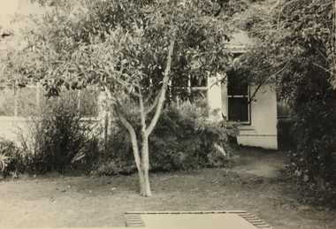
Photograph, Glendonald School for the Deaf, Marshall Avenue, 1955-1965
Glendonald School for Deaf Children was run by the Victorian Education Department. It provided education and some residential services for deaf children. The school was situated in Marshall Avenue, Kew and operated from 1951–91. Deaf children whose families lived too far to travel daily were housed in a grand Victorian mansion in Belmont Avenue, Kew, the John Cannon Hostel. The school and hostel also accommodated a small number of wards of the state. (Source: Glendonald School for Deaf Children 1951–91)Glendonald was a significant mansion in Kew (now demolished) built for the industrialist and manufacturer Donald Leslie in 1886. The school was purchased by the Victorian Department of Education on 29 November 1950 for the sum of 16,500 pounds.Trampoline in the garden of Glendonald, Marshall Avenue (Kew).The old school for the deaf at 17 Marshall Ave for children from the age of six years to ten years old, then they would go to 25 Marshall Ave to finish their schooling leaving age 16 years old. glendonald - marshall avenue - kew (vic), education - deaf children - victoria -
 Kew Historical Society Inc
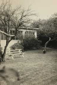
Photograph, Glendonald School for the Deaf, Marshall Avenue, 1955-1965
Glendonald School for Deaf Children was run by the Victorian Education Department. It provided education and some residential services for deaf children. The school was situated in Marshall Avenue, Kew and operated from 1951–91. Deaf children whose families lived too far to travel daily were housed in a grand Victorian mansion in Belmont Avenue, Kew, the John Cannon Hostel. The school and hostel also accommodated a small number of wards of the state. (Source: Glendonald School for Deaf Children 1951–91)Glendonald was a significant mansion in Kew (now demolished) built for the industrialist and manufacturer Donald Leslie in 1886. The school was purchased by the Victorian Department of Education on 29 November 1950 for the sum of 16,500 pounds.Garden, Glendonald, Marshall Avenue (Kew).The old school for the deaf at 17 Marshall Ave for children from the age of six years to ten years old, then they would go to 25 Marshall Ave to finish their schooling leaving age 16 years old. glendonald - marshall avenue - kew (vic), education - deaf children - victoria -
 Kew Historical Society Inc
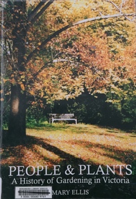
Book, Mary Ellis, People & Plants: A history of gardening in Victoria, 2003
Fish Creek., Victoria : Mary Ellis : c2003 172 p. : ill.(some col.)., ports. : 30 cm. non-fictiongardening - victoria - history, mary ellis, gardens -- victoria -- history., gardeners -- victoria -- biography. -
 Kew Historical Society Inc
Journal - Visitor Book, Grace Tabulo, Fairyland Lady And Children, 1958-1959
"Fairyland", the home of Jim and Grace Tabulo, was a major local, state and international tourist attraction situated in Kew, Victoria during the mid twentieth century. Located at 57 Malmsbury Street, Kew, the weatherboard house and its garden were heavily decorated with statues, crockery and other collected items. A series of notebooks were used to record the messages of child and adult visitors to the property from the 1940s to the 1960s. After Mrs Tabulo's death, these visitor books are believed to have formed part of the Dorothy Rogers Collection. They entered the Kew Historical Society's collection following her death in 1973.This series of visitor books are the most important primary sources relating to the internationally renowned 'Fairyland' cottage in Malmsbury Street, Kew. Their social significance is that they record in the post war period the values and beliefs of children and adults who visited this historically significant tourist attraction.Foolscap visitor book containing newspaper clippings, handwritten comments and drawings relating to visits to the home of Grace Tabulo, 57 Malmsbury Street Kew, known as Fairyland, June 1958 - April 1959. The book is wrapped in brown paper, which covers a grey card and red cloth strip binding. Creator's title inscription is located under the brown paper on front cover. 120pp. Mrs TABULO/ FAIRYLAND/ LADY/ AND CHILDREN./ c.1959grace tabulo, fairyland - 57 malmsbury street (kew), tourism - kew - 1945-1965, childhood - kew, collectors and collecting, gardens - kew (vic), scrapbooks - 20th century -
 Kew Historical Society Inc
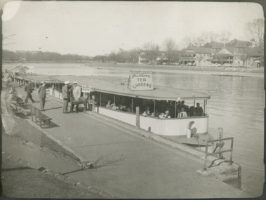
Photograph - Hicks' Cruiser berthed on the Yarra at Princess Bridge, c.1953
Commercially-operated boat tours on the Maribyrnong and Yarra Rivers in Melbourne were a major tourist attraction, especially in the first half of the twentieth century. A number of companies ran ferries and motor-launches to locations such as the Riverview Tea Gardens (1909-1947) at Ascot Vale, and the Hawthorn Tea Gardens on the corner of Power Street and Riversdale Road. One of the families which ran these services was Hicks Bros, which from circa 1921 operated a ferry service from Princess Walk (Melbourne) to Studley Park. This is one of a series of 17 black and white undated photographic proofs donated to the Kew Historical Society in 2013 by the Queenscliffe Historical Museum. The series includes images of individuals, tea rooms, ferries, motor launches, ocean liners and tugs. In 1953, the owner of Hicks Bros was involved in an inquest into the drowning of a Ukrainian tourist on a ferry operated by Melbourne Ferries, a rival firm. In published reports of the inquest, reference is made to a number of photographs taken by Robert Irvine Atchison, part-owner of Hicks Bros. As the reverse of the photographs indicates copyright is held by the State of Victoria, the collection may have derived from that year.Black and white print of a tourist cruiser berthed on the River Yarra at Princess Bridge. The sign on the cruiser says 'Tea Gardens' so its destination may have been the Hawthorn Tea Gardens. The single story, wide barge like roofed ferry has passengers on board. The ticket seller can be seen beside the boat on the moorings. tourism -- melbourne (vic.), ferries, yarra river, hick's cruises, hawthorn tea gardens -
 Kew Historical Society Inc
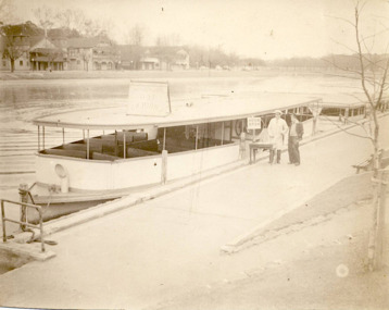
Photograph - Hicks' Cruises ticket seller at Princess Bridge, c.1953
Commercially-operated boat tours on the Maribyrnong and Yarra Rivers in Melbourne were a major tourist attraction, especially in the first half of the twentieth century. A number of companies ran ferries and motor-launches to locations such as the Riverview Tea Gardens (1909-1947) at Ascot Vale, and the Hawthorn Tea Gardens on the corner of Power Street and Riversdale Road. One of the families which ran these services was Hicks Bros, which from circa 1921 operated a ferry service from Princess Walk (Melbourne) to Studley Park. This is one of a series of 17 black and white undated photographic proofs donated to the Kew Historical Society in 2013 by the Queenscliffe Historical Museum. The series includes images of individuals, tea rooms, ferries, motor launches, ocean liners and tugs. In 1953, the owner of Hicks Bros was involved in an inquest into the drowning of a Ukrainian tourist on a ferry operated by Melbourne Ferries, a rival firm. In published reports of the inquest, reference is made to a number of photographs taken by Robert Irvine Atchison, part-owner of Hicks Bros. As the reverse of the photographs indicates copyright is held by the State of Victoria, the collection may have derived from that year.Closeup photograph of a ticket seller touting for business for a tourist ferry moored at Princess Bridge The sign on the boat identifies the destination of the ferry as 'Studley Park via Hawthorn Tea Gardens'. The ferry is empty of passengers.hicks' cruises, tourism -- melbourne (vic.), river yarra, studley park, hawthorn tea gardens -
Kew Historical Society Inc
Journal, The Kewriosity Sheet Vol.4 No.3 : October 1982
St Paul's School for the Blind and Visually Handicapped / p1. Volunteer drivers needed [Kew Community Bus] / p1. East Central Weights and Measures Union / p1. Uniting Church East Kew - Dairy [sic] for October / p2. Save the Children Fund / p2. Kew Skin Diving Club / p2. Kew Library [Deafness Awareness Week] / p2. St Paul's luncheon and fashion parade / p2. Scouts 50th anniversary dinner [6th Kew Scouts] / p3. Kew Garden Club / p3. R.A.A.V. [Rheumatism and Arthritis Association of Victoria] / p3. Patchwork quilts [Exhibition; Australian Quilters Association] / p3. Cabaret [Kew Baptist Church Young People's Cabaret] / p3. Hyde Park Fellowship [Hyde Park Uniting Church] / p3. Annual Fete [St Paul's East Kew] / p3. They built well: State School No. 1075, Peel Street, Kew [school history] / p4. Native Plant Group / p4.The Kewriosity Sheet (1979-83) was first published in the City of Kew (Victoria) in June 1979 as a two-sided 'community newssheet'. It aimed to: 'share news about Kew happenings and Kew people, and to exchange ideas about living in Kew'. Later issues gradually evolved into a 4-page, quarto sized publication. The Kewriosity Sheet was superseded by the Kew Council publication 'Kewriosity' (1983-1994).non-fictionSt Paul's School for the Blind and Visually Handicapped / p1. Volunteer drivers needed [Kew Community Bus] / p1. East Central Weights and Measures Union / p1. Uniting Church East Kew - Dairy [sic] for October / p2. Save the Children Fund / p2. Kew Skin Diving Club / p2. Kew Library [Deafness Awareness Week] / p2. St Paul's luncheon and fashion parade / p2. Scouts 50th anniversary dinner [6th Kew Scouts] / p3. Kew Garden Club / p3. R.A.A.V. [Rheumatism and Arthritis Association of Victoria] / p3. Patchwork quilts [Exhibition; Australian Quilters Association] / p3. Cabaret [Kew Baptist Church Young People's Cabaret] / p3. Hyde Park Fellowship [Hyde Park Uniting Church] / p3. Annual Fete [St Paul's East Kew] / p3. They built well: State School No. 1075, Peel Street, Kew [school history] / p4. Native Plant Group / p4.community publications --- kew (vic.), the kewriosity sheet, newsletters - kew (vic.) -
Kew Historical Society Inc
Journal - Visitor Book, Fairyland 1963-1965
"Fairyland", the home of Jim and Grace Tabulo, was a major local, state and international tourist attraction situated in Kew, Victoria during the mid twentieth century. Located at 57 Malmsbury Street, Kew, the weatherboard house and its garden were heavily decorated with statues, crockery and other collected items. A series of notebooks were used to record the messages of child and adult visitors to the property from the 1940s to the 1960s. After Mrs Tabulo's death, these visitor books are believed to have formed part of the Dorothy Rogers Collection. They entered the Kew Historical Society's collection following her death in 1973.This series of visitor books are the most important primary sources relating to the internationally renowned 'Fairyland' cottage in Malmsbury Street, Kew. Their social significance is that they record in the post war period the values and beliefs of children and adults who visited this historically significant tourist attraction.Visitor book containing handwritten comments and drawings primarily made by children during visits to the home of Grace Tabulo, in the period 6 January 1963 to 26 December 1965. Commonly known as "Fairyland", the house was located at 57 Malmsbury Street Kew. The book is wrapped in brown paper, which covers a black binding. Unpaginated, 93pp. On front cover: "MRS TABULO: 1879-1966/ "FAIRY HOUSE" / 1963 /- /1965" On title page: "FAIRY LAND Kew / JANUARY 6th 1963"grace tabulo, fairyland - 57 malmsbury street (kew), tourism - kew - 1945-1965, childhood - kew, collectors and collecting, gardens - kew (vic), scrapbooks - 20th century -
Kew Historical Society Inc
Journal - Visitor Book, Fairyland 1956-1957
"Fairyland", the home of Jim and Grace Tabulo, was a major local, state and international tourist attraction situated in Kew, Victoria during the mid twentieth century. Located at 57 Malmsbury Street, Kew, the weatherboard house and its garden were heavily decorated with statues, crockery and other collected items. A series of notebooks were used to record the messages of child and adult visitors to the property from the 1940s to the 1960s. After Mrs Tabulo's death, these visitor books are believed to have formed part of the Dorothy Rogers Collection. They entered the Kew Historical Society's collection following her death in 1973.This series of visitor books are the most important primary sources relating to the internationally renowned 'Fairyland' cottage in Malmsbury Street, Kew. Their social significance is that they record in the post war period the values and beliefs of children and adults who visited this historically significant tourist attraction.Diary repurposed as a visitor book and containing handwritten comments and drawings primarily made by children during visits to the home of Grace Tabulo, 1956-1957. Commonly known as "Fairyland", the house was located at 57 Malmsbury Street Kew. The book is wrapped in brown paper, which covers maroon and black card covers that are decorated with stickers of the British Royal Family. Unpaginated, 94pp. Handwritten on paper front cover: "MRS GRACE TABULO: 1879-1965/ FAIRY HOUSE [sic] / 1956 / 1957" Printed on card cover: "COLLINS / AUSTRAL/ DIARY/ 1948/ NO 926" Handwritten inside cover: "FAIRY LAND / Kew / February 22 1956""grace tabulo, fairyland - 57 malmsbury street (kew), tourism - kew - 1945-1965, childhood - kew, collectors and collecting, gardens - kew (vic), scrapbooks - 20th century -
Kew Historical Society Inc
Journal - Visitor Book, Fairyland 1959-1960
"Fairyland", the home of Jim and Grace Tabulo, was a major local, state and international tourist attraction situated in Kew, Victoria during the mid twentieth century. Located at 57 Malmsbury Street, Kew, the weatherboard house and its garden were heavily decorated with statues, crockery and other collected items. A series of notebooks were used to record the messages of child and adult visitors to the property from the 1940s to the 1960s. After Mrs Tabulo's death, these visitor books are believed to have formed part of the Dorothy Rogers Collection. They entered the Kew Historical Society's collection following her death in 1973.This series of visitor books are the most important primary sources relating to the internationally renowned 'Fairyland' cottage in Malmsbury Street, Kew. Their social significance is that they record in the post war period the values and beliefs of children and adults who visited this historically significant tourist attraction.Foolscap visitor book and containing handwritten comments and drawings primarily made by children during visits to the home of Grace Tabulo, May 1959- August 1960. Commonly known as "Fairyland", the house was located at 57 Malmsbury Street Kew. The book is wrapped in brown paper, which covers blue and red card covers with green cloth strip binding. Several pages of the book have entries which have been made upside-down. Unpaginated, 80pp. Handwritten on paper front cover: "1959 / 1960" Handwritten inside cover: "Fairy Land / 57 Malmsbury St/ Kew""grace tabulo, fairyland - 57 malmsbury street (kew), tourism - kew - 1945-1965, childhood - kew, collectors and collecting, gardens - kew (vic), scrapbooks - 20th century -
Kew Historical Society Inc
Journal - Visitor Book
"Fairyland", the home of Jim and Grace Tabulo, was a notable local, state and international tourist attraction situated in Kew, Victoria during the mid twentieth century. Located at 57 Malmsbury Street, Kew, the weatherboard house and its garden were heavily decorated with statues, crockery and other collected items. A series of notebooks were used to record the messages of child and adult visitors to the property from the 1940s to the 1960s. After Mrs Tabulo's death, these visitor books are believed to have formed part of the Dorothy Rogers Collection. They entered the Kew Historical Society's collection following Dorothy Roger's death in 1973.This series of visitor books are the most important primary sources relating to the internationally renowned 'Fairyland' cottage in Malmsbury Street, Kew. Their social significance is that they record in the post war period the values and beliefs of children and adults who visited this historically significant tourist attraction.A rectangular notebook with a clear plastic front cover and black plastic rear cover with a maroon plastic patch. Unpaginated, approximately 50 loose pale blue-grey pages with red printed lines, held in place by black plastic spine at top edge. The notebook contains handwritten comments and drawings primarily made by children during visits to "Fairyland", at 57 Malmsbury Street, Kew, c.1949. grace tabulo -- fairyland -- 57 malmsbury street -- kew (vic.), tourism - kew - 1945-1965, childhood - kew, collectors and collecting, gardens - kew (vic), scrapbooks - 20th century -
Kew Historical Society Inc
Journal - Visitor Book, [1962-1963]
"Fairyland", the home of Jim and Grace Tabulo, was a notable local, state and international tourist attraction situated in Kew, Victoria during the mid twentieth century. Located at 57 Malmsbury Street, Kew, the weatherboard house and its garden were heavily decorated with statues, crockery and other collected items. A series of notebooks were used to record the messages of child and adult visitors to the property from the 1940s to the 1960s. After Mrs Tabulo's death, these visitor books are believed to have formed part of the Dorothy Rogers Collection. They entered the Kew Historical Society's collection following Dorothy Roger's death in 1973.This series of visitor books are the most important primary sources relating to the internationally renowned 'Fairyland' cottage in Malmsbury Street, Kew. Their social significance is that they record in the post war period the values and beliefs of children and adults who visited this historically significant tourist attraction.Foolscap size visitor book containing handwritten comments and drawings primarily made by children during visits to the home of Grace Tabulo, 4 January 1962- 30 January 1963. Commonly known as "Fairyland", the house was located at 57 Malmsbury Street Kew. The book is wrapped in brown paper, which covers back cardboard covers with a red cloth strip binding. Approximately 139 pages, and covers. Note pages are paginated, commencing at page 36.Handwritten in pencil on paper cover: "1962/ 1963" Handwritten in ink on label adhered to front cover: "January 4 / 1962 / Fairy Land/ Kew"grace tabulo -- fairyland -- 57 malmsbury street -- kew (vic.), tourism - kew - 1945-1965, childhood - kew, collectors and collecting, gardens - kew (vic), scrapbooks - 20th century -
 Kew Historical Society Inc
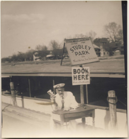
Photograph - Hicks Bros Launch at Princess Walk, circa 1953
Commercially-operated boat tours on the Maribyrnong and Yarra Rivers in Melbourne were a major tourist attraction, especially in the first half of the twentieth century. A number of companies ran ferries and motor-launches to locations such as the Riverview Tea Gardens (1909-1947) at Ascot Vale, and the Hawthorn Tea Gardens on the corner of Power Street and Riversdale Road. One of the families which ran these services was Hicks Bros, which from circa 1921 operated a ferry service from Princess Walk (Melbourne) to Studley Park. This is one of a series of 17 black and white undated photographic proofs donated to the Kew Historical Society in 2013 by the Queenscliffe Historical Museum. The series includes images of individuals, tea rooms, ferries, motor launches, ocean liners and tugs. In 1953, the owner of Hicks Bros was involved in an inquest into the drowning of a Ukrainian tourist on a ferry operated by Melbourne Ferries, a rival firm. In published reports of the inquest, reference is made to a number of photographs taken by Robert Irvine Atchison, part-owner of Hicks Bros. As the reverse of the photographs indicates copyright is held by the State of Victoria, the collection may have derived from that year.Historically significant and rare image of one of the major tour boat services which operated on the Yarra River.Faded black and white photographic proof of a ferry owned by Hicks Bros on the River Yarra at Princess Walk. Two employees stand beside the first of a number of wooden ferries. On the south side of the river, there are the pavilions of a number of boat clubs.ferries, motor launches, yarra river, maribyrnong river, studley park, princess walk, riverview tea gardens, hawthorn tea gardens, tourism - melbourne (vic.), hicks bros, hicks bros launches -
 Kew Historical Society Inc
Photograph - Hicks Bros Launch at Princess Walk, circa 1953
Commercially-operated boat tours on the Maribyrnong and Yarra Rivers in Melbourne were a major tourist attraction, especially in the first half of the twentieth century. A number of companies ran ferries and motor-launches to locations such as the Riverview Tea Gardens (1909-1947) at Ascot Vale, and the Hawthorn Tea Gardens on the corner of Power Street and Riversdale Road. One of the families which ran these services was Hicks Bros, which from circa 1921 operated a ferry service from Princess Walk (Melbourne) to Studley Park. This is one of a series of 17 black and white undated photographic proofs donated to the Kew Historical Society in 2013 by the Queenscliffe Historical Museum. The series includes images of individuals, tea rooms, ferries, motor launches, ocean liners and tugs. In 1953, the owner of Hicks Bros was involved in an inquest into the drowning of a Ukrainian tourist on a ferry operated by Melbourne Ferries, a rival firm. In published reports of the inquest, reference is made to a number of photographs taken by Robert Irvine Atchison, part-owner of Hicks Bros. As the reverse of the photographs indicates copyright is held by the State of Victoria, the collection may have derived from that year.Historically significant and rare image of one of the major tour boat services which operated on the Yarra River.Faded black and white photographic proof of a ferry owned by Hicks Bros on the River Yarra at Princess Walk. The ferry has signage confirming the company (Hicks Bros Launches) and the destinations (Studley Park, Hawthorn Tea Rooms). A man, probably Robert Atchison, co-owner of the ferry service, in a captain's hat is selling tickets. Above the roof line of the ferry can be seen the boat houses on the opposite bank. ferries, motor launches, yarra river, maribyrnong river, studley park, princess walk, riverview tea gardens, hawthorn tea gardens, tourism - melbourne (vic.), hicks bros, hicks bros launches -
 Kew Historical Society Inc
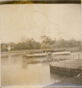
Photograph - Ferry on the Yarra River, circa 1953
Commercially-operated boat tours on the Maribyrnong and Yarra Rivers in Melbourne were a major tourist attraction, especially in the first half of the twentieth century. A number of companies ran ferries and motor-launches to locations such as the Riverview Tea Gardens (1909-1947) at Ascot Vale, and the Hawthorn Tea Gardens on the corner of Power Street and Riversdale Road. One of the families which ran these services was Hicks Bros, which from circa 1921 operated a ferry service from Princess Walk (Melbourne) to Studley Park. This is one of a series of 17 black and white undated photographic proofs donated to the Kew Historical Society in 2013 by the Queenscliffe Historical Museum. The series includes images of individuals, tea rooms, ferries, motor launches, ocean liners and tugs. In 1953, the owner of Hicks Bros was involved in an inquest into the drowning of a Ukrainian tourist on a ferry operated by Melbourne Ferries, a rival firm. In published reports of the inquest, reference is made to a number of photographs taken by Robert Irvine Atchison, part-owner of Hicks Bros. As the reverse of the photographs indicates copyright is held by the State of Victoria, the collection may have derived from that year.Historically significant and rare image of one of the major tour boat services which operated on the Yarra River.Faded black and white photographic proof of a ferry, possibly one of a number owned by Hicks Bros on the River Yarra. The single storey wooden ferry has a wheel that is motor driven. The popularity of ferry services is indicated by the number of passengers on board.ferries, motor launches, yarra river, studley park, princess walk, hawthorn tea gardens, tourism - melbourne (vic.), hicks bros, hicks bros launches -
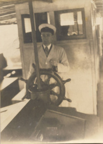 Kew Historical Society Inc
Photograph - Hicks Bros Motor Launch, circa 1953
Commercially-operated boat tours on the Maribyrnong and Yarra Rivers in Melbourne were a major tourist attraction, especially in the first half of the twentieth century. A number of companies ran ferries and motor-launches to locations such as the Riverview Tea Gardens (1909-1947) at Ascot Vale, and the Hawthorn Tea Gardens on the corner of Power Street and Riversdale Road. One of the families which ran these services was Hicks Bros, which from circa 1921 operated a ferry service from Princess Walk (Melbourne) to Studley Park. This is one of a series of 17 black and white undated photographic proofs donated to the Kew Historical Society in 2013 by the Queenscliffe Historical Museum. The series includes images of individuals, tea rooms, ferries, motor launches, ocean liners and tugs. In 1953, the owner of Hicks Bros was involved in an inquest into the drowning of a Ukrainian tourist on a ferry operated by Melbourne Ferries, a rival firm. In published reports of the inquest, reference is made to a number of photographs taken by Robert Irvine Atchison, part-owner of Hicks Bros. As the reverse of the photographs indicates copyright is held by the State of Victoria, the collection may have derived from that year.Historically significant and rare image of one of the major tour boat services which operated on the Yarra River.Faded black and white photographic proof of worker of a ferry service, steering a ferry on the Yarra River. He wears a captain's peaked hat and a coat.ferries, motor launches, yarra river, studley park, princess walk, hawthorn tea gardens, tourism - melbourne (vic.), hicks bros, hicks bros launches