Showing 14941 items
matching view-finder
-
 Glenelg Shire Council Cultural Collection
Photograph, Aerial view of Cape Grant, n.d
Port of Portland Authority archives.port of portland, cape grant quarry -
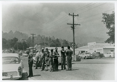 Mt Dandenong & District Historical Society Inc.
Photograph, Street view Mt Dandenong during 1962 bushfires, 1962
Taken during the 1962 bushfires. View of Mount Dandenong shops opposite the Hotel with garage to the right. 8 men in foreground with smoke clearly visible.mount dandenong, mt dandenong road, bushfire -
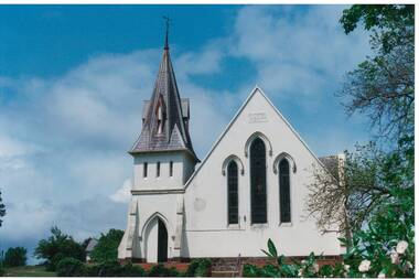 Buninyong & District Historical Society
Photograph - Original Photograph, Clive Brooks, Buninyong Uniting Church (1860, formerly Presbyterian) Learmonth St. front view from east, 9 Nov. 1991
detail of historic buildingBuninyong Uniting Church (1860, formerly Presbyterian) Learmonth St. front view from east, showing steeple and gothic arched windows and entrance.buninyong, church, presbyterian, uniting, learmonth st. -
 University of Melbourne, Burnley Campus Archives
Photograph - Black and white print, Aerial View of Burnley Campus c.1965, c. 1965
Black and white photograph. Enlarged photograph of aerial view of Burnley College encompassed by the Yarra River and showing the surrounding suburban areas. Mounted on cardboard.aerial view, burnley college, yarra river -
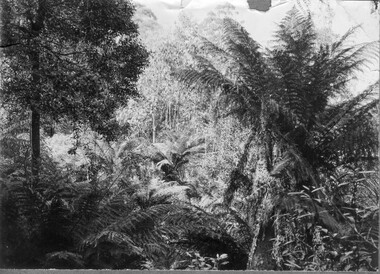 University of Melbourne, Burnley Campus Archives
Photograph - Black and white print, Victorian Rainforest View, Unknown
Black and white photograph. View of ferns and Eucalypts. Possibly an excursion. Photographs B91.409 to B91.417 appear to have come from the same photograph album.ferns, eucalypts, excursion, victorian rainforest -
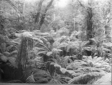 University of Melbourne, Burnley Campus Archives
Photograph - Black and white print, Victorian Rainforest View, Unknown
Black and white photograph. View of ferns and trees. Possibly an excursion. Photographs B91.409 to B91.417 appear to have come from the same photograph album.ferns, trees, excursion, victorian rainforest -
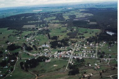 Linton and District Historical Society Inc
Photograph, Photographer: Alan Giles, Aerial View, Sussex Street, Linton, 1991, 1.9.1991
Aerial view of Linton, Sussex St (Glenelg Highway) running from RH bottom corner, Mortchup Road reservoir centre RH side."Linton Township, Vic-1st September 1991".linton township, sussex street linton -
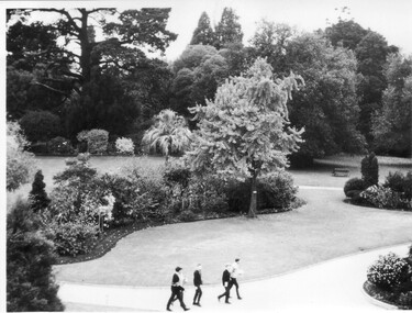 University of Melbourne, Burnley Campus Archives
Photograph - Black and white print, Garden View, 1955-1960
Black and white photograph. Garden view looking down from the Administration Building at the Emily Gibson garden beds in front of it. A group of students on the path.garden view, administration building, garden beds, emily gibson, students -
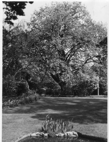 University of Melbourne, Burnley Campus Archives
Photograph - Black and white print, Garden View
Large black and white photograph in cardboard frame, the same as B93.727. View across the central lawn from clumps of iris by the pond to the Oak tree.garden view, lawn, iris, pond, oak tree -
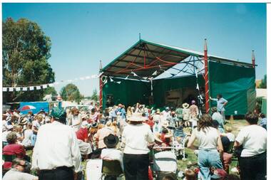 Buninyong & District Historical Society
Photograph - Colour photograph, Buninyong Gold King Festival Feb.Feb.1996, view of new De Soza Stage, Buninyong Gold King Festival Feb.Feb.1996 view of new De Soza Stage
The Gold King festival celebrated transport and notable characters associated with Buninyong's early gold mining and farming days.The Gold King Festival was held for many years and was an important community celebration in the late 20th centuryColour photo, Buninyong Gold King Festival Feb.Feb.1995, view of the opening of the new De Soza stage in De Soza Park BuninyongDe Soza Stage opened 17 February 1996mining, gold king, de soza, de soza stage opening -
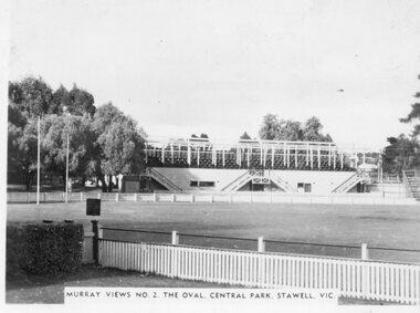 Stawell Historical Society Inc
Photograph, Murray Views, The Oval at Central Park in Stawell c1950 -- Postcard, C 1950
Sister of Donor Visited Stawell in th e1950'2 When she Purchased thes Murray Views Cards. The Cards were produced for sale to touristsSet of 8 Murry Views Postcards No 1 to No 8 C. 1950Murrray Views No 2 The Oval Central Park Stawell -
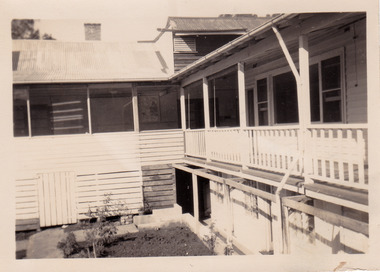 Marysville & District Historical Society
Photograph (item) - Black and white photograph, 1953
A black and white photograph of the view of the verandah from a guest's room at The Cumberland in Marysville. The photograph was taken in 1953.A black and white photograph of the view of the verandah from a guest's room at The Cumberland in Marysville. The photograph was taken in 1953.VIEW FROM/ WINDOW/ "CUMBERLAND"/ MARYSVILLE '53marysville, victoria, austalia, the cumberland, the cumberland guest house, cumberland house, accommodation, photograph -
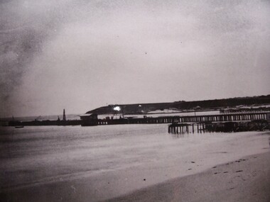 Glenelg Shire Council Cultural Collection
Photograph - Photograph/Postcard - View of Portland Harbour, View of Portland Harbour, n.d
Displayed at History House.Black and white photo. Images shows bare Battery Point, buildings under cliff, pier with building at end , another building (Baths?) and uprights in ocean.Front: View of Portland Harbour Back: State Library of South Australia, Photographic Section. Reproduction prohibited except with the permission of the copywirte holders. Order No. A/6493 -
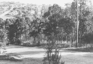
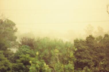 Ringwood and District Historical Society
Photograph, View west from 79 Wantirna Road. Approaching dust storm 1983
Catalogue card reads, "View west from 79 Wantirna Road. Approaching dust storm. Temperature 3 p.m. 43.5C. 8/2/1983". -
 Ringwood and District Historical Society
Photograph, View of Glenvale Road, Ringwood. Warnes Road in left background 1964
See Also #25Written on back of photograph, "1964 - View of Glenvale Road. Supplied by Garrett Gundry. Warnes Road in left background. Deep Creek Road in centre background." -
 Ringwood and District Historical Society
Photograph, View of Glenvale Road, Ringwood 1964
See Also #25Written on back of photograph, "1964 - View of Glenvale Road. Supplied by Garrett Gundry. Warnes Road in left background. Deep Creek Road in centre background." -
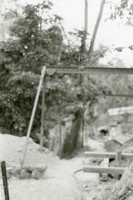 Ringwood and District Historical Society
Photographs, 1979-80 MMBW pipe line project at Hubbard Reserve, North Ringwood � View along MMBW work line in east end of Hibberd's, showing grating over mole boring pit
Part of a 43-photo record of the MMBW�s engineering feat in drilling a 12 inch pipe line up to 40 feet deep through rock hardened by volcanic action associated with geological fault that occurs along the line. The work took place from October 1979 to May 1980 on the southern boundary of Hubbard Reserve, North Ringwood. The collection was presented to the Ringwood Historical Research Group by J Clarke on 9th June 1980.E560 N29 Feb 1980 A43 View along MMBW work line in east end of Hibberd's, showing grating over mole boring pit -
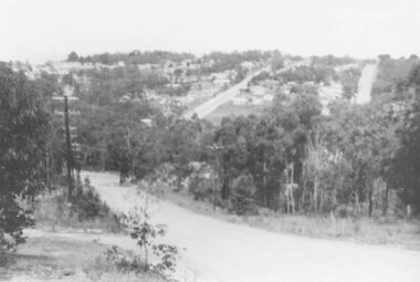
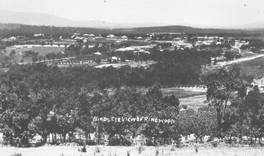 Ringwood and District Historical Society
Photograph, Birds eye view of Ringwood 1912
Written onto photograph, "Birds eye view of Ringwood". Small photograph notes that photograph was taken in 1912 and that is shows the brickworks and Reimers house in Warrandyte Rd. -
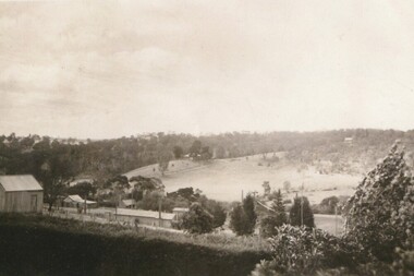 Greensborough Historical Society
Photograph - Digital image, View of Lower Greensborough from Grimshaw Street, 1920c
View of rural Greensborough, late 19th or early 20th century.Shows the rural nature of the Greensborough landscape at this time.Digital copy of black and white photograph.greensborough -
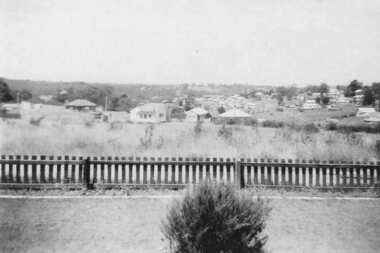 Greensborough Historical Society
Photograph - Digital image, View from 11 Anama Street Greensborough, 1949c
View of Greensborough from the Evans home at 11 Anama Street.Digital copy of black and white photographanama street, evans family, june evans, june hall nee evans -
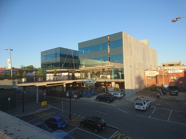 Greensborough Historical Society
Photograph - Digital image, Marilyn Smith, 78 Main Street Construction - Rear View, 18/01/2016
Development on Main Street Greensborough (rear view), January 2016. Shows the changing streetscape of Main Street.Digital copy of colour photographmain street greensborough -
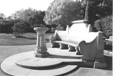 Stawell Historical Society Inc
Photograph, Close up view of the Memorial Seat & Sundial at Central Park Stawell
Close up view of Seat and Sundial at Central Park Stawellstawell -
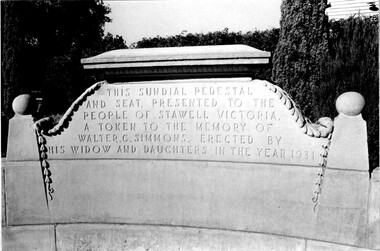 Stawell Historical Society Inc
Photograph, Close up view of the Inscription on the Memorial Seat at Central Park Stawell
Close up view of Inscription on Seat at Central Park Stawellstawell -
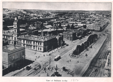 Ballarat Tramway Museum
Photograph - Illustration, "View of Ballarat today", c1910
Illustration or photograph taken from the Town Hall, looking North East towards Black Hill. The Post Office, railway yards, Sturt St buildings are in view. Has a tram eastbound at Lydiard St and another waiting to depart Grenville St. There are two horse-drawn cabs in the view. The road surfaces have marks - either from being watered or graded. On the rear is a photograph of R O Henderson's New Furniture warehouse, View Point Bendigo. Yields information of Ballarat c1910.Black and white Illustration cut from a journal"1912" in pencil alongside the image title.tramways, trams, sturt st, esco, grenville st, bridge st, lydiard st north, black hill, post office -
Glenelg Shire Council Cultural Collection
Photograph, View of Portland Harbour and port, 1960s
Port of Portland Authority archives.Front: (no inscriptions) Back: (no inscriptions)port of portland, lady bay -
 Eltham District Historical Society Inc
Photograph, View from Porter Street, Eltham to south east, c.1994, 1994c
Colour photograph of view southeast from Porter Street, Eltham c.1994 showing new housing development on Riverview Estate formerly Fabbro farm.porter street, eltham, riverview estate, m fabbro -
 Ringwood and District Historical Society
Photograph, Exterior view of Ringwood North State Bank , north-east corner of Dickson's Cresent and Warrandyte Road
The new Ringwood North State Bank premises on the north-east corner of Dickson's Cresent. Exterior view. Unknown date. Opened 25 October 1971At the corner of Dickson's Cresent and Warrandyte Road, Ringwood North. Photographer Laurie Richards, 4 Tower Avenue, Alphington. Negative #71-3031 -
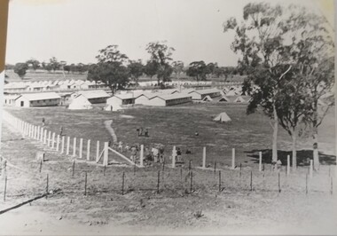 Tatura Irrigation & Wartime Camps Museum
Photograph, Camp 13 View, 1940
Photograph donated to Museum by Fred Ruddy who was one of the guards at Camp 13.Black and white photograph. General view from corner perimeter of Camp 13. Huts and tents particularly. It would seem tents the sleeping quarters of the guards.camp 13, fred ruddy, camp 13 sleeping quarters -
 Buninyong & District Historical Society
Photograph - B/W photograph, Eyre Cottage, former home of Robert Allen, c 1855, on S/W cnr. of Eyre and Winter Streets, side view from N/W, 1994
Original Building dates from around 1855, strong connection with Robert Allen, prominent citizen in early goldrush, links through him to Allen Store and Old Library.Built by prominent citizen and benefactor, early gold-rush dwellingEyre Cottage, former home of Robert Allen, c 1855, on S/W cnr. of Eyre and Winter Streets, side view from N/W.buninyong, eyre st, winter st, robert allen, streetscape, building -
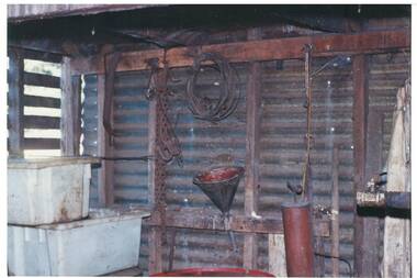 Buninyong & District Historical Society
Photograph - Original Photograph, Geoff Little, Whykes Slaughterhouse, Durham Lead, interior of boiler house, corner view, 1995
IndustryWhykes Slaughterhouse, Slaughterhouse Lane, Durham Lead, Whykes Slaughterhouse, Durham Lead, interior of boiler house, corner view. Colour and b/w copiesbuninyong, whykes, slaughterhouse, durham lead, butchers, boiler house