Showing 560 items
matching west creek
-
 Whitehorse Historical Society Inc.
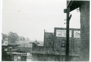
Photograph, Snow Falling, 1/08/1951 12:00:00 AM
Black and white photo of snow falling at Mitcham. From Post Office looking west.mitcham -
 Whitehorse Historical Society Inc.
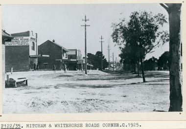
Photograph, Whitehorse Road, Mitcham, C1925
Black and white photo of Whitehorse Road, Mitcham looking west -1925. Note the Mitcham Hardware Store (Ironmongery), the Post Office and Drake & Co. Section shown is further west than actual corner. Monty Gray's ironmongery was approximately half way down the block between Mitcham Road and Station Street. Horse trough later moved to front of Reserve Hotel. Drake and Co. shown on one of their several locations.whitehorse road, mitcham, mitcham post office, drake & co, mitcham hardware store, ironmongery -
 Whitehorse Historical Society Inc.
Photograph, Mrs Jenning's Sweet Shop, C.1950s
Black and white photo of Mrs Jenning's Sweet Shop in group shops on west side of Boronia Road and south of Canterbury Road, Vermont.jennings, mrs., sweet shops -
 Whitehorse Historical Society Inc.
Photograph, First shop Vermont, C.1907
Black and white photo of Vermont Corner about 1907, looking west from site of Shell garage. This was first shop in Vermont. Carts in front were typical in early 1900s.pannam, charles, pannam's store -
 Whitehorse Historical Society Inc.
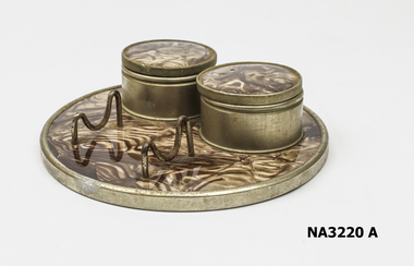
Container - Ink Well
Ink wells belonged to Anthony Docherty of West Footscray who died in 1934.Two metal ink well set on a round metal base covered in brown & cream mottled celluloid.Made in Germanydomestic items, writing equipment -
 Whitehorse Historical Society Inc.
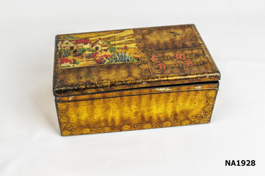
Container - Tin Box
Sweet tinGold painted illustrated tin, decorated.East West Homes Best on liddomestic items, containers, metalcraft, tinware -
 Whitehorse Historical Society Inc.
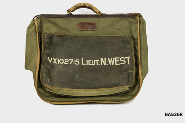
Functional object - Officers Dress Bag
World War 2 Noel Edmund Charles WestLarge khaki Army Dress bag with handle and many compartments VX102715 Lieut. N. West.VX102715 Lieut. N. Westarmy, bag, w.w.2, noel edmund charles west -
 Whitehorse Historical Society Inc.
Map, Melbourne and Metropolitan Board of Works, Feb 1982
Map area: North - Laburnum and Blackburn Stations East - Blackburn Lake South - bordering Canterbury Road West - Middleborough Roadnon-fictionMap area: North - Laburnum and Blackburn Stations East - Blackburn Lake South - bordering Canterbury Road West - Middleborough Roadmaps, melbourne and metropolitan board of works, parish of nunawading -
 Whitehorse Historical Society Inc.
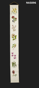
Decorative object - Wall hanging
Domestic object demonstrating Australian State Floral symbolsA cross stitched wall hanging on a brass hanger. The white cotton background has the Australian native flower emblems in a line down the centre. Firstly the Australian emblem - golden Wattle, then New South Wales - Waratah, Victoria - Common Heath, Northern Territory -Sturt's Desert Rose, West Australia - Kangaroo paw, Queensland - Cooktown Orchid, Tasmania - Blue Gum, West Australia - Sturt Desert pea.embroidery, australian floral emblems -
 Ballarat Heritage Services
Photograph - Digital photograph, Dorothy Wickham, Winter's Swamp, Ballarat, January to April 2014
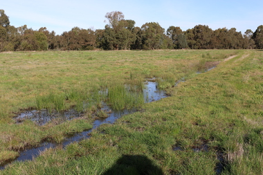
Study of Winter's Swamp commissioned by BEN and completed by BHS. The swamp was named after one of the first European settlers in the district. Winter Swamp LAT -37 32 LONG 143 47, Parish of Dowling Forest, County of Grenville Winter Swamp, on the southwest corner of Ballarat West Town Common, was not included in the original proclamation of the Common in 1861. However, being marshland, it was not considered suitable for grazing, so was added to the Common soon after 1861. Winter Swamp is a large wetland with native and exotic pasture significant for wildlife. John Winter (Jock) was born in Berwickshire, Scotland. He married Janet Margaret Irving the daughter of Robert Irving, advocate, Bonshaw, Dumfries, Scotland. Winter died in Ballarat in 1875 and was buried at the Ballaarat Old Cemetery. He took up the run Bonshaw from 1841; Leigh River Buninyong 1842-46; Junction, Delatite, March 1851 to September 1862; with sons: Carag Carag and Corop, April 1857 to September 1872; Colbinabbin and Stewart’s Plains, April 1857 to December 1872; St Germains February 1867 to March 1871. (The name became Winter-Irving in 1890). Mr John Winter, who died on August 22 at the age of 72, was a man of some note it the mining community of Ballarat. He was a self-made man, and one of our oldest colonists, it being over a quarter of a century age since he took up county about Ballarat and settled at Bonshaw. He died very rich. It is calculated that if he had retained an interest in all his runs, his income must have been not less than £10,000 or £50,000 a year. Some eight or ten years ago he sold his Bonshaw pre-emption to the Bonshaw Gold mining Company for £20,000, and a few years later the ground belonging now to Winter's Freehold Company brought him £50,000 more, the payment being made at the requisition of the deceased in sovereigns. In these relations Mr. Winter has been closely identified with the mining industry at Ballarat. The deceased was a native of Lauder, in Berwickshire, and landed in Victoria several years before the gold discovery.The principle task of this project was the delivery of a report outlining the history of European settlement in the Skipton and Cardigan/Ballarat districts as pertinent to the use of and impact on the natural environment of the two reserves Skipton Common and Winter Swamp. The report was delivered in digital form only. The report, upon completion, was presented to the Network’s Committee in order to discuss the project. The report identified and described the uses of Skipton Common and Winter Swamp, and their impacts. In particular, this report examined farming/grazing (official and informal), mining, vegetation removal (including the removal of woodlands for timber, grasslands for pasture improvement) & use of riparian areas for access to water and timber removal. Recording the more benign and environmentally friendly uses such as picnicking, community activities, nature walks and the roles of organisations such as Field Naturalists’ and Bird Observers’ clubs, school and scout/guide groups will be relevant in helping to depict overall community attitudes towards the reserves; e.g.: has the Common generally been viewed as little more than a grazing paddock and fire hazard; has Winter Swamp always been the unknown natural asset that seems to have been its lot for at least the past 40 years? In this regard, the more contemporary history of actions surrounding the use and management of the reserves is of particular interest, in view of the extant evidence at both reserves; e.g. the actions of the Shire of Ballarat in the 1980s in establishing Winter Swamp as something of a competitor to Lake Wendouree but with a more environmental bent (although almost none of the plants used are indigenous species, but that is part of the story); the trotting track constructed on Skipton Common in the 1960s following representations to Premier Henry Bolte and the cropping of the western section of the Common to raise funds for the town’s new swimming pool, the fertilizing of the land putting an end to the native grassland vegetation. There are obviously multiple sources of information to source in preparing the report, however sources that the contractor is specifically requested to consult are the Skipton Historical Society, the former Skipton Common managers (specifically Graeme Pett), the Cardigan Windermere Landcare Group and the Learmonth Historical Society (believed to hold many of the former Shire of Ballarat’s records pertaining to the Council’s role as the Committee of Management for both Winter Swamp and the Ballarat West Town Common – Winter Swamp was split between 2 separate Crown Land tenures). The contractor is also encouraged but not required to utilise community newsletters, such as the Skipton Community Newsletter, to publicise and seek information about the project. Skipton Historical Society (Mary Bradshaw) contacted on Thursday 12 June 2.30pm. Mary lived on a farm out of Skipton but is currently living in the township. She remembers walking along the creek of the Common especially in spring and autumn in bare feet and that it was a very pretty place. There were a few snakes around the waterway in summer. People put cows and a couple of horses on the commonage to graze. Graeme Pett has always lived close to the Common and would know a lot about it. Other possible contacts would be Nicole Petress, Secretary of the Progress Association, and the Corangamite Council, Camperdown. Digital images of Winter's Swampwinter's swamp, ballarat, john winter, ballarat environmental network, mullawullah -
 Ballarat Heritage Services
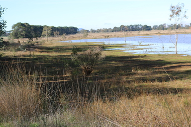
Photograph - Digital photograph, Winter's Swamp surrounds, April 2014
The swamp was named after John (Jock) Winter. John Winter (Jock) was born in Berwickshire, Scotland. He married Janet Margaret Irving the daughter of Robert Irving, advocate, Bonshaw, Dumfries, Scotland. Winter died in Ballarat in 1875 and was buried at the Ballaarat Old Cemetery. He took up the run Bonshaw from 1841; Leigh River Buninyong 1842-46; Junction, Delatite, March 1851 to September 1862; with sons: Carag Carag and Corop, April 1857 to September 1872; Colbinabbin and Stewart’s Plains, April 1857 to December 1872; St Germains February 1867 to March 1871. (The name became Winter-Irving in 1890). Mr John Winter, who died on August 22 at the age of 72, was a man of some note it the mining community of Ballarat. He was a self-made man, and one of our oldest colonists, it being over a quarter of a century age since he took up county about Ballarat and settled at Bonshaw. He died very rich. It is calculated that if he had retained an interest in all his runs, his income must have been not less than £10,000 or £50,000 a year. Some eight or ten years ago he sold his Bonshaw pre-emption to the Bonshaw Gold mining Company for £20,000, and a few years later the ground belonging now to Winter's Freehold Company brought him £50,000 more, the payment being made at the requisition of the deceased in sovereigns. In these relations Mr. Winter has been closely identified with the mining industry at Ballarat. The deceased was a native of Lauder, in Berwickshire, and landed in Victoria several years before the gold discovery. BHS were commissioned by Ballarat Environment Network for a project on Winter's Swamp and Skipton Common. Winter's Swamp was part of Ballarat West Common. The principle task of this project was the delivery of a report outlining the history of European settlement in the Skipton and Cardigan/Ballarat districts as pertinent to the use of and impact on the natural environment of the two reserves Skipton Common and Winter Swamp. The report was delivered in digital form only. The report, upon completion, was presented to the Network’s Committee in order to discuss the project. The report identified and described the uses of Skipton Common and Winter Swamp, and their impacts. In particular, this report examined farming/grazing (official and informal), mining, vegetation removal (including the removal of woodlands for timber, grasslands for pasture improvement) & use of riparian areas for access to water and timber removal. Recording the more benign and environmentally friendly uses such as picnicking, community activities, nature walks and the roles of organisations such as Field Naturalists’ and Bird Observers’ clubs, school and scout/guide groups will be relevant in helping to depict overall community attitudes towards the reserves; e.g.: has the Common generally been viewed as little more than a grazing paddock and fire hazard; has Winter Swamp always been the unknown natural asset that seems to have been its lot for at least the past 40 years? In this regard, the more contemporary history of actions surrounding the use and management of the reserves is of particular interest, in view of the extant evidence at both reserves; e.g. the actions of the Shire of Ballarat in the 1980s in establishing Winter Swamp as something of a competitor to Lake Wendouree but with a more environmental bent (although almost none of the plants used are indigenous species, but that is part of the story); the trotting track constructed on Skipton Common in the 1960s following representations to Premier Henry Bolte and the cropping of the western section of the Common to raise funds for the town’s new swimming pool, the fertilizing of the land putting an end to the native grassland vegetation. There are obviously multiple sources of information to source in preparing the report, however sources that the contractor is specifically requested to consult are the Skipton Historical Society, the former Skipton Common managers (specifically Graeme Pett), the Cardigan Windermere Landcare Group and the Learmonth Historical Society (believed to hold many of the former Shire of Ballarat’s records pertaining to the Council’s role as the Committee of Management for both Winter Swamp and the Ballarat West Town Common – Winter Swamp was split between 2 separate Crown Land tenures). The contractor is also encouraged but not required to utilise community newsletters, such as the Skipton Community Newsletter, to publicise and seek information about the project. Skipton Historical Society (Mary Bradshaw) contacted on Thursday 12 June 2.30pm. Mary lived on a farm out of Skipton but is currently living in the township. She remembers walking along the creek of the Common especially in spring and autumn in bare feet and that it was a very pretty place. There were a few snakes around the waterway in summer. People put cows and a couple of horses on the commonage to graze. Graeme Pett has always lived close to the Common and would know a lot about it. Other possible contacts would be Nicole Petress, Secretary of the Progress Association, and the Corangamite Council, Camperdown. Mary can’t remember any photos in the Skipton Historical Society that pertain to the Common. Digital photos of Winter's swamp surrounds, later known as Mullawullah.winter, winter's swamp surrounds, winter's swap, john winter, ballarat environmental network, ballarat, mullawullah -
 Ballarat Heritage Services
Photograph - Colour, Clare Gervasoni, Fawcett Hall and Public Library, 2015, 11/01//2015
Fawcett Hall is 14 kilometres North West of Alexandra, North East Victoria, in Spring Creek Road and is set amongst a small picturesque rural farming and business community with hills as a backdrop and Stony Creek running alongside the public reserves property boundary. Part of our hall building dates back to its establishment in 1882. Originally the hall served as a Mechanics Institute and Public Library and later as a primary school.Colour photograph of a weatherboard Hall.fawcett hall and public library, fawcett, fawcett mechanics' institute -
 Ballarat Heritage Services
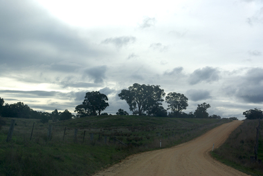
Photograph - Photograph - Colour, Clare Gervasoni, Tarilta, 2017, 16/07/2017
Tarilta is a rural locality and former gold-mining town 12 km south of Castlemaine, 4 km north-west of Guildford and 3 km north-east of Vaughan. The last gold mining activity took place around the 1880s. It was originally Kangaroo Flat, being located where the Kangaroo Creek enters the Loddon River. It was surveyed and named in 1864. Gold was discovered at Tarilta in 1853. The Tarilta School was opened in 1860 in a Wesleyan chapel, and closed i n1925. In 1864 a township was surveyed and named Tarilta, the word being derived from an Aboriginal expression thought to mean kangaroo. In 1865 Bailliere’s Victorian gazetteer described Tarilta as being an alluvial and quartz gold-mining town with three quartz-crushing mills, three horse-puddling machines and two hotels. The elevated nature of the land around Tarilta made it accessible only by horse and dray, or on horseback. Colour photograph of Tarilta in Central Victoria. tarilta, central victoria, landcape -
 Whitehorse Historical Society Inc.
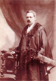
Photograph, Charles Frederick/Francis Rooks
Son of Abraham Rooks, (17/8/1824-1/9/1889) who emigrated from England, 1857 on board the 'Grand Trianon' with wife Sarah, and three children (John, Edward and Edmund). Charles, son of Abraham was elected to Council, 1940. Representing West Central Ward when he died, 1959. Mayor, City of Nunawading 1946-47 and 1955-56.Sepia photograph taken in mayoral robes with hand resting on ornamental chair. Birth registration as Charles Frederick Rooks afterwards known as Charles Francis Rooks.rooks, charles francis -
 Whitehorse Historical Society Inc.
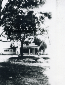
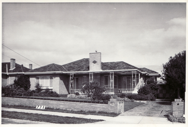
Photograph, Mullen's House East Burwood
Black and white photograph of the Mullen's family home, built c1960. It was situated at 342 Blackburn Road, East Burwood 2 houses west of Burwood Road.burwood east, mullen's home c1960 -
 Whitehorse Historical Society Inc.
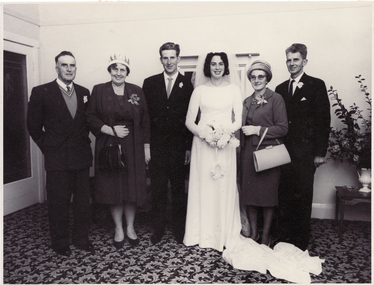
Photograph, Mullens/Blanksby Wedding
The Mullens family were one of the first to settle in the East Burwood area. They were orchardists with property on the north-west corner of Burwood and Springvale Roads.Black and white photograph of the marriage of Ivan Mullens of East Burwood, to Joy Blanksby. From right to left - Bruce Roy Mullens, Thelma Mary Mullens, Groom and Bride, Glen Blanksby, Harold Blanksby. The group is in a reception room with a leaf-patterned carpet.blanksby, joy, mullens, ivan, bruce roy, thelma mary, glen, harold -
 Whitehorse Historical Society Inc.
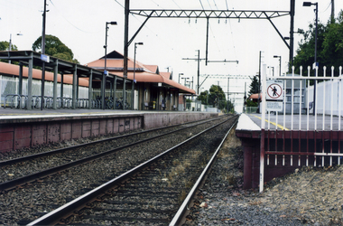
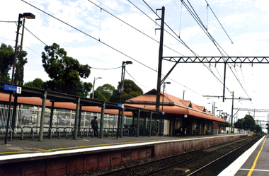
Photograph, Mitcham Railway Station
2013 - Station dismantled - going undergroundColoured photograph of Mitcham Railway Station looking west towards the city - 2012mitcham railway station, railways -
 Whitehorse Historical Society Inc.
Photograph, Mitcham Railway Station
Coloured photograph of Mitcham Railway Station southern platform looking west towards the city -2012mitcham railway station, railways -
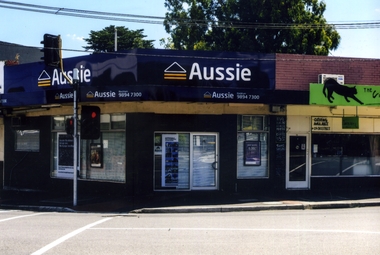
 Whitehorse Historical Society Inc.
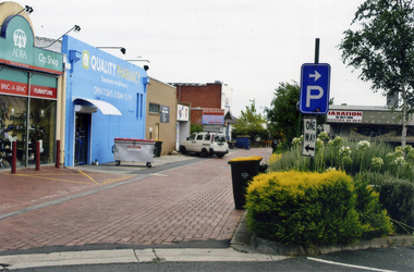
Photograph, Enterprise Way Mitcham
Mitcham - Commercial Area behind Coles etcColoured photograph of Enterprise Way, Mitcham which is a pedestrian and service road between the shops on Whitehorse Road and Coles Supermarket and vicinity shops on Victoria Avenue.This photograph is looking west from Mitcham Road - 2012enterprise way mitcham, shops -
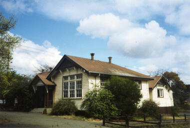
 Whitehorse Historical Society Inc.
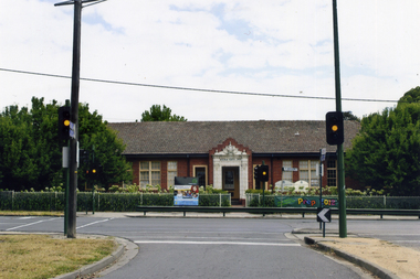
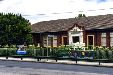
Photograph, Mitcham Primary School No 2904
On 24th September 1888 a wooden state school opened on land purchased on the north west corner of Whitehorse and Mitcham Roads. In 1890 a contract was let for the construction of a one-room brick school house on that site. By 1907 student numbers had risen to 120 so the Church of Christ Hall was leased for 10/- a week. By 1922 cracks had appeared, plaster had fallen in the school and both the Brittania Street Scout Hall and the Methodist Church has been leased for classrooms. On 10/4/1930, a new school, to be occupied by the upper grades was opened in its present location.Coloured picture of Mitcham Primary School No 2904 The traffic lights are at the intersection of Mitcham and Doncaster East Roads - 2012mitcham primary school no. 2904, schools -
 Whitehorse Historical Society Inc.
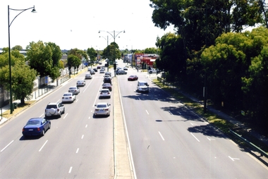
Photograph, Whitehorse Road, Blackburn, 2012
Coloured photograph of Whitehorse Road Blackburn looking west, Surrey Road enters Whitehorse Road near the red building on the right - 2012whitehorse road, blackburn, roads, transport -
 Whitehorse Historical Society Inc.
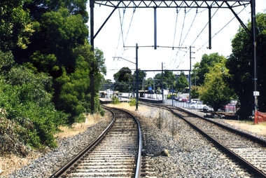
Photograph, Blackburn Railway Line, 2012
See NP3406Coloured photograph of the railway line near the Blackburn station, heading west towards the 'city' - 2012. Car park to right.blackburn railway station, transport -
 Whitehorse Historical Society Inc.
Photograph, Blackburn Railway Station, 2012
See NP3406Coloured photograph of the railway line near the Blackburn station, heading west towards the 'city Entry is from Railway Road and South Parade via a tunnel - 2012blackburn railway station, railways -
 Whitehorse Historical Society Inc.
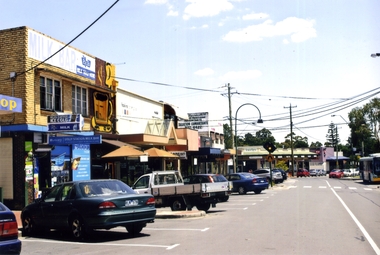
Photograph, Blackburn, South Parade, 2012
See NP4006Coloured photograph of South Parade Blackburn looking west. Bus on right is dropping people off at south side of the Blackburn station - 2012south parade, blackburn, shops, shopping -
 Whitehorse Historical Society Inc.
Photograph, Chapel Street, Blackburn, 2012
Coloured photographs of shops on the north-west corner of the junction of Railway Parade and Chapel Street, Blackburn, Post Office on the opposite corner.chapel street, blackburn, shops, shopping -
 Whitehorse Historical Society Inc.
Photograph, Vermont Primary School No 3133, 1980's
The first of the Vermont Primary School buildings was erected on 1872. In 1907 a room was built onto the west side of the building and a new classroom and cloakroom were erected in 1922. Due to rising numbers and traffic volume, Vermont Progress Association urged the government to relocate the school buildings to a less prominent site, and new school buildings were erected in Nurlendi Street in the 1950's. The original timber building remained on the site until its removal to the Nurlendi Street site in the 1990's, and is on the city of Whitehorse Heritage Review.Coloured photograph of the Vermont Primary School while it was standing vacant from the 1950's until 1989 when it was moved to the main school in Nurlendi Road, Vermont. The school was on the North West corner of Canterbury and Mitcham roads facing Mitcham Road. Canterbury Road can be seen through the trees at the left of the photograph.vermont primary school no 3133, primary schools -
 Whitehorse Historical Society Inc.
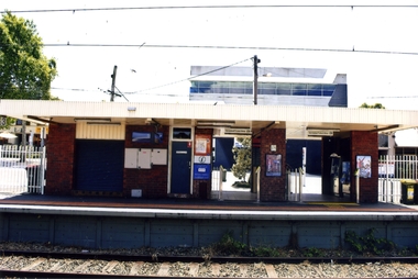
Photograph, Blackburn Railway Station
Coloured photograph taken of the southern side of the Blackburn Railway station looking west towards the city. Car park to the right is accessed from the Railway Road, Blackburnblackburn railway station -
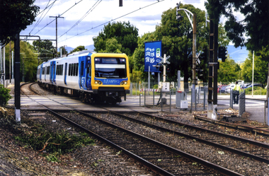 Whitehorse Historical Society Inc.
Photograph, Mitcham Railway Crossing, 2012
Coloured photograph of a Metro train crossing Mitcham Road and heading west towards the Cityrailway line, mitcham, mitcham railway crossing, metro trains -
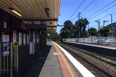
 Whitehorse Historical Society Inc.
Photograph - Coloured photograph, Mitcham Railway Station, 2012
See NP4000Coloured photograph of the southern platform of the Mitcham Railway Station looking west - 2012. The station was relocated underground in 2013mitcham railway station, railway station, railways -
 Whitehorse Historical Society Inc.
Photograph, Mitcham State School No 2904, 2012
See NP3945Coloured photograph of the Mitcham State School situated on the west side of Mitcham Road, opposite East Doncaster Road. Sign on the fence requesting 2012 prep enrolments.mitcham state school no 2904, state schools