Showing 450 items
matching yarra river -- kew
-
 Kew Historical Society Inc
Photograph - Flooding of the Yarra Valley at Kew East, 1974
Flooding of the Yarra Valley, including that section of the Yarra bordering Kew and Kew East in the north and west of the municipality, was a regular occurrence. Extreme flood events of the Yarra River are recorded to have occurred in 1891, 1901, 1916, 1923 and 1934. The Municipality of Kew's response to these floods was to enact planning decisions restricting residential development in flood prone areas following the floods of 1916, 1921 and 1934. While floods continued after the development of the Upper Yarra Reservoir (construction 1948-57), the regularity and extent of these inundations diminished. During the nineteenth century, the land abutting the south side of the Yarra in Kew was devoted to dairy farming. In the twentieth century, before and after the construction of the Eastern Freeway, much of this low-lying area was used as golf courses and public parks.Late example of the capacity of the Yarra Valley at Kew to flood, even though drainage works and the Upper Yarra Reservoir had reduced their regularity.Original black and white print photograph of the low-lying land at East Kew under floodwater on 16 May 1974. The vantage point of the photographer is Lister Street. Flooding was caused by overflowing water in Glass' Creek and the River Yarra. Annotation verso: "Lister Street looking north / Flood level / 16 May 1974 11.30am / R.L. 46.04"hays paddock, floods, yarra river, glass' creek, lister street -
 Kew Historical Society Inc
Photograph - Flooding of the Yarra Valley at Kew East, 1974
Flooding of the Yarra Valley, including that section of the Yarra bordering Kew and Kew East in the north and west of the municipality, was a regular occurrence. Extreme flood events of the Yarra River are recorded to have occurred in 1891, 1901, 1916, 1923 and 1934. The Municipality of Kew's response to these floods was to enact planning decisions restricting residential development in flood prone areas following the floods of 1916, 1921 and 1934. While floods continued after the development of the Upper Yarra Reservoir (construction 1948-57), the regularity and extent of these inundations diminished. During the nineteenth century, the land abutting the south side of the Yarra in Kew was devoted to dairy farming. In the twentieth century, before and after the construction of the Eastern Freeway, much of this low-lying area was used as golf courses and public parks.Late example of the capacity of the Yarra Valley at Kew to flood, even though drainage works and the Upper Yarra Reservoir had reduced their regularity.Original black and white print photograph of Hay's Paddock under floodwater on 16 May 1974. The vantage point of the photographer is Keystone Crescent looking east. Flooding was caused by overflowing water in Glass' Creek and the River Yarra. Annotation verso: "Keystone Cr looking east / 16 May 1974 11.50am"hays paddock, floods, yarra river, glass' creek -
 Kew Historical Society Inc
Photograph - Flooding of the Yarra Valley at Kew East, 1974
Flooding of the Yarra Valley, including that section of the Yarra bordering Kew and Kew East in the north and west of the municipality, was a regular occurrence. Extreme flood events of the Yarra River are recorded to have occurred in 1891, 1901, 1916, 1923 and 1934. The Municipality of Kew's response to these floods was to enact planning decisions restricting residential development in flood prone areas following the floods of 1916, 1921 and 1934. While floods continued after the development of the Upper Yarra Reservoir (construction 1948-57), the regularity and extent of these inundations diminished. During the nineteenth century, the land abutting the south side of the Yarra in Kew was devoted to dairy farming. In the twentieth century, before and after the construction of the Eastern Freeway, much of this low-lying area was used as golf courses and public parks.Late example of the capacity of the Yarra Valley at Kew to flood, even though drainage works and the Upper Yarra Reservoir had reduced their regularity.Original black and white print photograph of the low-lying land at East Kew under floodwater on 16 May 1974. The vantage point of the photographer is Lister Street. Flooding was caused by overflowing water in Glass' Creek and the River Yarra. Annotation verso: "Lister St looking same as No.3 / 16 May 1974 11.30"floods, yarra river, glass' creek, lister street -
 Kew Historical Society Inc
Photograph - Flooding of the Yarra Valley at Kew East, 1974
Flooding of the Yarra Valley, including that section of the Yarra bordering Kew and Kew East in the north and west of the municipality, was a regular occurrence. Extreme flood events of the Yarra River are recorded to have occurred in 1891, 1901, 1916, 1923 and 1934. The Municipality of Kew's response to these floods was to enact planning decisions restricting residential development in flood prone areas following the floods of 1916, 1921 and 1934. While floods continued after the development of the Upper Yarra Reservoir (construction 1948-57), the regularity and extent of these inundations diminished. During the nineteenth century, the land abutting the south side of the Yarra in Kew was devoted to dairy farming. In the twentieth century, before and after the construction of the Eastern Freeway, much of this low-lying area was used as golf courses and public parks.Late example of the capacity of the Yarra Valley at Kew to flood, even though drainage works and the Upper Yarra Reservoir had reduced their regularity.Original black and white print photograph of the low-lying land at East Kew under floodwater on 16 May 1974. The vantage point of the photographer is at Willsmere Road. The road itself is underwater.Annotation verso: "Willsmere Rd / Same as No.7 / 16 May 1974 11.15am"floods, yarra river, willsmere road -
 Kew Historical Society Inc
Photograph - Flooding of the Yarra Valley at Kew East, 1974
Flooding of the Yarra Valley, including that section of the Yarra bordering Kew and Kew East in the north and west of the municipality, was a regular occurrence. Extreme flood events of the Yarra River are recorded to have occurred in 1891, 1901, 1916, 1923 and 1934. The Municipality of Kew's response to these floods was to enact planning decisions restricting residential development in flood prone areas following the floods of 1916, 1921 and 1934. While floods continued after the development of the Upper Yarra Reservoir (construction 1948-57), the regularity and extent of these inundations diminished. During the nineteenth century, the land abutting the south side of the Yarra in Kew was devoted to dairy farming. In the twentieth century, before and after the construction of the Eastern Freeway, much of this low-lying area was used as golf courses and public parks.Late example of the capacity of the Yarra Valley at Kew to flood, even though drainage works and the Upper Yarra Reservoir had reduced their regularity.Original black and white print photograph of the low-lying land at East Kew under floodwater on 16 May 1974. The photograph is of Hyde Park looking north-east.Annotation verso: "Hyde Park looking nth-east / Flood Level / 16 May 1974 11.15am / R.L. 46.61"floods, yarra river, hyde park -
 Kew Historical Society Inc
Photograph - Flooding of the Yarra Valley at Kew, 1974
Flooding of the Yarra Valley, including that section of the Yarra bordering Kew and Kew East in the north and west of the municipality, was a regular occurrence. Extreme flood events of the Yarra River are recorded to have occurred in 1891, 1901, 1916, 1923 and 1934. The Municipality of Kew's response to these floods was to enact planning decisions restricting residential development in flood prone areas following the floods of 1916, 1921 and 1934. While floods continued after the development of the Upper Yarra Reservoir (construction 1948-57), the regularity and extent of these inundations diminished. During the nineteenth century, the land abutting the south side of the Yarra in Kew was devoted to dairy farming. In the twentieth century, before and after the construction of the Eastern Freeway, much of this low-lying area was used as golf courses and public parks.Late example of the capacity of the Yarra Valley at Kew to flood, even though drainage works and the Upper Yarra Reservoir had reduced their regularity.Original black and white print photograph of the low-lying land at East Kew under floodwater on 16 May 1974. The photograph is taken from 43 Kellett Grove.Annotation verso: "Kellett Gve No.43 / Flood Level / 16 May 1974 11.40am"floods, yarra river, kellett grove -
 Kew Historical Society Inc
Book, Colin Jones, Ferries on the Yarra, 1981
Collingwood, Vic. : Greenhouse, 1981 108 pages : ill., map ; 26 cm. non-fictionferry services -- ferries -- melbourne -- yarra river, ferries -- victoria =- yarra river -- history, ferries -- victoria -- melbourne -- history. -
Kew Historical Society Inc
Book, Francis Jordan, Guide to historical resources of the Yarra Valley, focusing on conservation and historic landscape, 1992
[Ormond, Vic. : F.I. Jordan], 1991 31 leaves : 1 map ; 30 cm. non-fictionconservation of natural resources -- victoria -- yarra river valley, landscape -- victoria -- yarra river valley -- history, ecology -- victoria -- yarra river valley, historic sites -- victoria -- yarra river valley, yarra river valley (vic.) -- history. -
 Kew Historical Society Inc
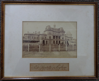
Photograph, Charles Nettleton, Kew Lunatic Asylum, c.1886
Following a Royal Commission in 1854, the building of a new Asylum at Kew began in 1864. It was built to replace the Yarra Bend Asylum on the Fairfield side of the Yarra River. Work started in 1864 and was completed in 1872 at a cost of ₤198,334. Operating over a period of 116 years, and often renamed to take account of public sensitivities, the ‘Kew Lunatic Asylum’ was one of the largest asylums built in Australia. ‘Willsmere’ was finally closed in December 1988 and sold by the Government of Victoria in the late 1980s. The photograph is by Charles Nettleton. He arrived in Victoria in 1854. In Melbourne he joined the studio of T. Duryea and Alexander McDonald and specialized in outdoor work. ... Nettleton opened his own studio in 1858. His souvenir albums were the first of the type to be offered to the public. However, when the dry-plate came into general use in 1885 he knew that the new process offered opportunities that were beyond his scope. Five years later his studio was closed (Source: ADB)A rare silver albumen photograph by the Victorian photographer Charles Nettleton.A framed original silver albumen photograph by Charles Nettleton showing the front of the Kew Lunatic Asylum.KEW LUNATIC ASYLUMkew lunatic asylum, studley park, charles nettleton, asylum, willsmere hospital, willsmere mental hospital, lunatic -
 Melbourne Tram Museum
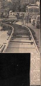
Newspaper, The Age, track reconstruction work in Bridge Road Richmond, c1974
Newspaper clipping from an undated Melbourne page, about track reconstruction work in Bridge Road Richmond, between Burnley St and the Yarra River. Shows the temporary trackwork slew along the road with a long line of cars alongside. In the distance is a tram showing Kew Depot, route 23. Work c1974.trams, tramways, bridge rd, trackwork, route 23, temporary track -
 Melbourne Tram Museum
Photograph - Digital Image, Kevin O'Reilly, Kew Barkers Rd, c1930
Image from CD (Compact Diskette for use in computers) - see Reg Item 135. Image titled "Kew Barkers Rd" on CD, looking west from over Kew Junction towards Victoria Bridge over the Yarra River. Has a W class tram, eastbound in Victoria St, about to cross the bridge. c1930 (Cable conversion late 1929)trams, tramways, kew, barkers rd, victoria st -
 Ballarat Heritage Services... Kew Boulevard Yarra River ...kew boulevard, yarra river
 -
 Kew Historical Society Inc
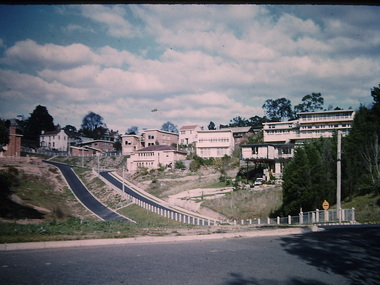
Photograph - Yarra Street, Kew, Ron Setford, 1960
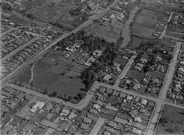
Ron Setford and his wife Grace Setford lived in Tanner Avenue, East Kew, from c.1946 to c.1995. A keen photographer, he recorded the changing face of Kew over a 20 year period. Apart from 30 photographs of built structures and places in Kew dating from 1960 and 1961, 145 of his 35mm colour slides chronicle the development of the Eastern Freeway through the Yarra Valley over a five year period from c.1972 to c.1977. This important collection was donated to the Society by his granddaughter in 2025.This collection of 175 35mm slides is of local and statewide significance, owing to its subject matter, particularly the major development of road transport infrastructure during the 1970s with the construction of the Eastern Freeway. The photographer also took care to annotate and date most of his slides which enable the researcher to pinpoint temporal and spatial locations.Yarra Street was not made a trafficable thoroughfare until October 1956. Until then, the gully was used as a dump, a shortcut to the river, and for communal Guy Fawkes night bonfires. The open landscape in the photo reflects near-total clearing by the original estate owners for grazing livestock. Post-war homes fronting Stawell St dot the landscape. Of particular note are the Broons House (c.1952–54) by Anatol Kagan (top right), and the homes of two architects, Kurt Elsner (c.1950) (middle) and Geoffrey Danne (c.1954) (lower right). Dual carriageways made blocks accessible, but building was difficult due to steeply sloping land and complex drainage easements. Nevertheless, these challenges resulted in highly innovative designs, making Yarra Street the core of the Yarra Boulevard Heritage Precinct."Yarra St Kew"ron setford, photographs -- kew (vic.) -- 1960s, yarra street -- kew (vic.) -
 Kew Historical Society Inc
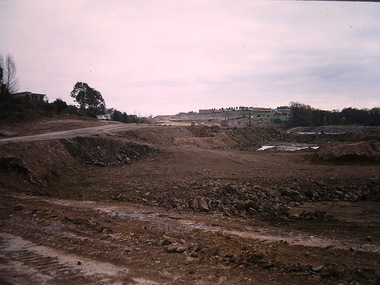
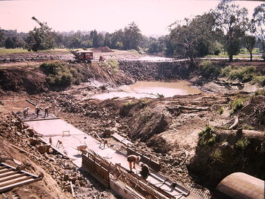
Photograph - Construction of the Eastern Freeway (F19), Ron Setford, March 1972
Ron Setford and his wife Grace Setford lived in Tanner Avenue, East Kew, from c.1946 to c.1995. A keen photographer, he recorded the changing face of Kew over a 20 year period. Apart from 30 photographs of built structures and places in Kew dating from 1960 and 1961, 145 of his 35mm colour slides chronicle the development of the F19 (later renamed Eastern) Freeway through the Yarra Valley in Kew over a five year period from c.1972 to c.1977. This important collection was donated to the Society by his granddaughter in 2025.This collection of 175 35mm slides is of local and statewide significance, owing to its subject matter, particularly the major development of road transport infrastructure during the 1970s with the construction of the Eastern Freeway. The photographer also took care to annotate and date most of his slides which enable the researcher to pinpoint temporal and spatial locations."Eastern Freeway 6/72 / Rock fill in old river bed"ron setford, eastern freeway, f19 freeway -
 Kew Historical Society Inc
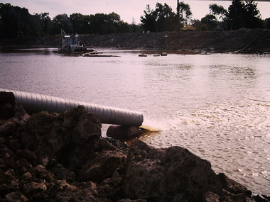
Photograph - Construction of the Eastern Freeway (F19), Ron Setford, March 1972
Ron Setford and his wife Grace Setford lived in Tanner Avenue, East Kew, from c.1946 to c.1995. A keen photographer, he recorded the changing face of Kew over a 20 year period. Apart from 30 photographs of built structures and places in Kew dating from 1960 and 1961, 145 of his 35mm colour slides chronicle the development of the F19 (later renamed Eastern) Freeway through the Yarra Valley in Kew over a five year period from c.1972 to c.1977. This important collection was donated to the Society by his granddaughter in 2025.This collection of 175 35mm slides is of local and statewide significance, owing to its subject matter, particularly the major development of road transport infrastructure during the 1970s with the construction of the Eastern Freeway. The photographer also took care to annotate and date most of his slides which enable the researcher to pinpoint temporal and spatial locations.Photograph of works involved in construction of the F19 (now Eastern) Freeway. The photo shows how construction sometimes took account of key environmental features; in this case the Kew Billabong."Eastern Freeway / pumping out of old river"ron setford, eastern freeway, f19 freeway -
 Kew Historical Society Inc
Photograph - Construction of the Eastern Freeway (F19), Ron Setford, March 1972
Ron Setford and his wife Grace Setford lived in Tanner Avenue, East Kew, from c.1946 to c.1995. A keen photographer, he recorded the changing face of Kew over a 20 year period. Apart from 30 photographs of built structures and places in Kew dating from 1960 and 1961, 145 of his 35mm colour slides chronicle the development of the F19 (later renamed Eastern) Freeway through the Yarra Valley in Kew over a five year period from c.1972 to c.1977. This important collection was donated to the Society by his granddaughter in 2025.This collection of 175 35mm slides is of local and statewide significance, owing to its subject matter, particularly the major development of road transport infrastructure during the 1970s with the construction of the Eastern Freeway. The photographer also took care to annotate and date most of his slides which enable the researcher to pinpoint temporal and spatial locations.Photograph of works involved in construction of the F19 (now Eastern) Freeway. The photo shows works diverting the former river bed of the Yarra near Kilby Road and Willsmere Road, Kew."Eastern Freeway / Old River Bed / Kilby-Willsmere Rd"ron setford, eastern freeway, f19 freeway -
 Kew Historical Society Inc
Photograph - Construction of the Eastern Freeway (F19), Ron Setford, March 1972
Ron Setford and his wife Grace Setford lived in Tanner Avenue, East Kew, from c.1946 to c.1995. A keen photographer, he recorded the changing face of Kew over a 20 year period. Apart from 30 photographs of built structures and places in Kew dating from 1960 and 1961, 145 of his 35mm colour slides chronicle the development of the F19 (later renamed Eastern) Freeway through the Yarra Valley in Kew over a five year period from c.1972 to c.1977. This important collection was donated to the Society by his granddaughter in 2025.This collection of 175 35mm slides is of local and statewide significance, owing to its subject matter, particularly the major development of road transport infrastructure during the 1970s with the construction of the Eastern Freeway. The photographer also took care to annotate and date most of his slides which enable the researcher to pinpoint temporal and spatial locations.Photograph of works involved in construction of the F19 (now Eastern) Freeway. The photo shows the old river bed of the Yarra and work to alter the Kew Main Drain where it originally entered the river. "Eastern Freeway / Old River Bed / Alterations to Kew S/water Drain"ron setford, eastern freeway, f19 freeway -
 Kew Historical Society Inc
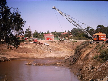
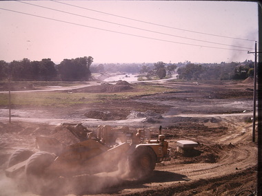
Photograph - Construction of the Eastern Freeway (F19), Ron Setford, March 1972
Ron Setford and his wife Grace Setford lived in Tanner Avenue, East Kew, from c.1946 to c.1995. A keen photographer, he recorded the changing face of Kew over a 20 year period. Apart from 30 photographs of built structures and places in Kew dating from 1960 and 1961, 145 of his 35mm colour slides chronicle the development of the F19 (later renamed Eastern) Freeway through the Yarra Valley in Kew over a five year period from c.1972 to c.1977. This important collection was donated to the Society by his granddaughter in 2025.This collection of 175 35mm slides is of local and statewide significance, owing to its subject matter, particularly the major development of road transport infrastructure during the 1970s with the construction of the Eastern Freeway. The photographer also took care to annotate and date most of his slides which enable the researcher to pinpoint temporal and spatial locations.Panoramic view of the Yarra Valley in March 1972 showing the early stages of the construction of the F19 (Eastern) Freeway. The photo shows the construction of an embankment to contain the new river course of the Yarra."Eastern Freeway / New river course preparing for embankment / Mar 72"ron setford, eastern freeway, f19 freeway -
 Kew Historical Society Inc
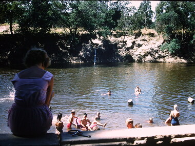
Photograph - Swimming in the Yarra River, Ron Setford, 1960-61
... -- Kew (Vic.) -- 1960s Yarra River Recreation -- river swimming ...Ron Setford and his wife Grace Setford lived in Tanner Avenue, East Kew, from c.1946 to c.1995. A keen photographer, he recorded the changing face of Kew over a 20 year period. Apart from 30 photographs of built structures and places in Kew dating from 1960 and 1961, 145 of his 35mm colour slides chronicle the development of the Eastern Freeway through the Yarra Valley over a five year period from c.1972 to c.1977. This important collection was donated to the Society by his granddaughter in 2025.This collection of 175 35mm slides is of local and statewide significance, owing to its subject matter, particularly the major development of road transport infrastructure during the 1970s with the construction of the Eastern Freeway. The photographer also took care to annotate and date most of his slides which enable the researcher to pinpoint temporal and spatial locations.Nilron setford, photographs -- kew (vic.) -- 1960s, yarra river, recreation -- river swimming -
![Photograph - Construction of the F19 [Eastern Freeway], Ron Setford, May 1976](/media/collectors/550653872162f11fb04854aa/items/68287c9964071e7c58e66ab5/item-media/68287cbb64071e7c58e66c8f/item-fit-380x285.jpg) Kew Historical Society Inc
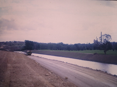
Kew Historical Society IncPhotograph - Construction of the F19 [Eastern Freeway], Ron Setford, May 1976
Ron Setford and his wife Grace Setford lived in Tanner Avenue, East Kew, from c.1946 to c.1995. A keen photographer, he recorded the changing face of Kew over a 20 year period. Apart from 30 photographs of built structures and places in Kew dating from 1960 and 1961, 145 of his 35mm colour slides chronicle the development of the F19 (later renamed Eastern) Freeway through the Yarra Valley in Kew over a five year period from c.1972 to c.1977. This important collection was donated to the Society by his granddaughter in 2025.This collection of 175 35mm slides is of local and statewide significance, owing to its subject matter, particularly the major development of road transport infrastructure during the 1970s with the construction of the Eastern Freeway. The photographer also took care to annotate and date most of his slides which enable the researcher to pinpoint temporal and spatial locations."Yarra River & Lagoon"ron setford, eastern freeway, f19 freeway -
![Photograph - Construction of the F19 [Eastern Freeway], Ron Setford, May 1976](/media/collectors/550653872162f11fb04854aa/items/68287a8a64071e7c58e6608b/item-media/68287ab064071e7c58e66255/item-fit-380x285.jpg) Kew Historical Society Inc
Kew Historical Society IncPhotograph - Construction of the F19 [Eastern Freeway], Ron Setford, May 1976
Ron Setford and his wife Grace Setford lived in Tanner Avenue, East Kew, from c.1946 to c.1995. A keen photographer, he recorded the changing face of Kew over a 20 year period. Apart from 30 photographs of built structures and places in Kew dating from 1960 and 1961, 145 of his 35mm colour slides chronicle the development of the F19 (later renamed Eastern) Freeway through the Yarra Valley in Kew over a five year period from c.1972 to c.1977. This important collection was donated to the Society by his granddaughter in 2025.This collection of 175 35mm slides is of local and statewide significance, owing to its subject matter, particularly the major development of road transport infrastructure during the 1970s with the construction of the Eastern Freeway. The photographer also took care to annotate and date most of his slides which enable the researcher to pinpoint temporal and spatial locations."Yarra River from Freeway"ron setford, eastern freeway, f19 freeway -
![Photograph - Construction of the F19 [Eastern Freeway], Ron Setford, May 1976](/media/collectors/550653872162f11fb04854aa/items/6828751564071e7c58e648e2/item-media/6828755564071e7c58e64940/item-fit-380x285.jpg) Kew Historical Society Inc
Kew Historical Society IncPhotograph - Construction of the F19 [Eastern Freeway], Ron Setford, May 1976
Ron Setford and his wife Grace Setford lived in Tanner Avenue, East Kew, from c.1946 to c.1995. A keen photographer, he recorded the changing face of Kew over a 20 year period. Apart from 30 photographs of built structures and places in Kew dating from 1960 and 1961, 145 of his 35mm colour slides chronicle the development of the F19 (later renamed Eastern) Freeway through the Yarra Valley in Kew over a five year period from c.1972 to c.1977. This important collection was donated to the Society by his granddaughter in 2025.This collection of 175 35mm slides is of local and statewide significance, owing to its subject matter, particularly the major development of road transport infrastructure during the 1970s with the construction of the Eastern Freeway. The photographer also took care to annotate and date most of his slides which enable the researcher to pinpoint temporal and spatial locations."Boulevard overpass by Fairfield river bdge / Dillingham contractor"ron setford, eastern freeway, f19 freeway -
 Kew Historical Society Inc
Photograph - Construction of the Eastern Freeway (F19), Ron Setford, November 1972
Ron Setford and his wife Grace Setford lived in Tanner Avenue, East Kew, from c.1946 to c.1995. A keen photographer, he recorded the changing face of Kew over a 20 year period. Apart from 30 photographs of built structures and places in Kew dating from 1960 and 1961, 145 of his 35mm colour slides chronicle the development of the F19 (later renamed Eastern) Freeway through the Yarra Valley in Kew over a five year period from c.1972 to c.1977. This important collection was donated to the Society by his granddaughter in 2025.This collection of 175 35mm slides is of local and statewide significance, owing to its subject matter, particularly the major development of road transport infrastructure during the 1970s with the construction of the Eastern Freeway. The photographer also took care to annotate and date most of his slides which enable the researcher to pinpoint temporal and spatial locations."New river course / Latrobe golf club across river / Nov 72"ron setford, eastern freeway, f19 freeway -
![Photograph - Construction of the F19 [Eastern Freeway], Ron Setford, ca. 1973](/media/collectors/550653872162f11fb04854aa/items/6804bf9ce716c23079f56c8e/item-media/6804bfc2e716c23079f56eab/item-fit-380x285.jpg) Kew Historical Society Inc
Kew Historical Society IncPhotograph - Construction of the F19 [Eastern Freeway], Ron Setford, ca. 1973
Ron Setford and his wife Grace Setford lived in Tanner Avenue, East Kew, from c.1946 to c.1995. A keen photographer, he recorded the changing face of Kew over a 20 year period. Apart from 30 photographs of built structures and places in Kew dating from 1960 and 1961, 145 of his 35mm colour slides chronicle the development of the F19 (later renamed Eastern) Freeway through the Yarra Valley in Kew over a five year period from c.1972 to c.1977. This important collection was donated to the Society by his granddaughter in 2025.This collection of 175 35mm slides is of local and statewide significance, owing to its subject matter, particularly the major development of road transport infrastructure during the 1970s with the construction of the Eastern Freeway. The photographer also took care to annotate and date most of his slides which enable the researcher to pinpoint temporal and spatial locations."Eastern Freeway / Bridge over river Fairfield - Kew / Hornibrook contractor"ron setford, eastern freeway, f19 freeway -
 Kew Historical Society Inc
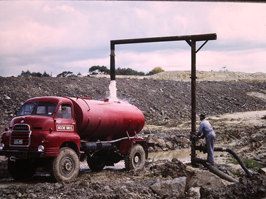
Photograph - Construction of the F19 [Eastern Freeway], Ron Setford, ca. 1973
Ron Setford and his wife Grace Setford lived in Tanner Avenue, East Kew, from c.1946 to c.1995. A keen photographer, he recorded the changing face of Kew over a 20 year period. Apart from 30 photographs of built structures and places in Kew dating from 1960 and 1961, 145 of his 35mm colour slides chronicle the development of the F19 (later renamed Eastern) Freeway through the Yarra Valley in Kew over a five year period from c.1972 to c.1977. This important collection was donated to the Society by his granddaughter in 2025.This collection of 175 35mm slides is of local and statewide significance, owing to its subject matter, particularly the major development of road transport infrastructure during the 1970s with the construction of the Eastern Freeway. The photographer also took care to annotate and date most of his slides which enable the researcher to pinpoint temporal and spatial locations."Eastern Freeway / Filling water tanker from river / 5/73"ron setford, eastern freeway, f19 freeway -
![Photograph - Construction of the F19 [Eastern Freeway], Ron Setford, October 1973](/media/collectors/550653872162f11fb04854aa/items/6808c3e9025de50d1e73220c/item-media/6808c404025de50d1e7324ef/item-fit-380x285.jpg) Kew Historical Society Inc
Kew Historical Society IncPhotograph - Construction of the F19 [Eastern Freeway], Ron Setford, October 1973
Ron Setford and his wife Grace Setford lived in Tanner Avenue, East Kew, from c.1946 to c.1995. A keen photographer, he recorded the changing face of Kew over a 20 year period. Apart from 30 photographs of built structures and places in Kew dating from 1960 and 1961, 145 of his 35mm colour slides chronicle the development of the F19 (later renamed Eastern) Freeway through the Yarra Valley in Kew over a five year period from c.1972 to c.1977. This important collection was donated to the Society by his granddaughter in 2025.This collection of 175 35mm slides is of local and statewide significance, owing to its subject matter, particularly the major development of road transport infrastructure during the 1970s with the construction of the Eastern Freeway. The photographer also took care to annotate and date most of his slides which enable the researcher to pinpoint temporal and spatial locations."Eastern Freeway / Chandler H/way to Fairfield / River Bridge Oct 73"ron setford, eastern freeway, f19 freeway -
![Photograph - Construction of the F19 [Eastern Freeway], Ron Setford, January 1977](/media/collectors/550653872162f11fb04854aa/items/683be10f69688f11138ec6f1/item-media/683be12f69688f11138eca95/item-fit-380x285.jpg) Kew Historical Society Inc
Kew Historical Society IncPhotograph - Construction of the F19 [Eastern Freeway], Ron Setford, January 1977
Ron Setford and his wife Grace Setford lived in Tanner Avenue, East Kew, from c.1946 to c.1995. A keen photographer, he recorded the changing face of Kew over a 20 year period. Apart from 30 photographs of built structures and places in Kew dating from 1960 and 1961, 145 of his 35mm colour slides chronicle the development of the F19 (later renamed Eastern) Freeway through the Yarra Valley in Kew over a five year period from c.1972 to c.1977. This important collection was donated to the Society by his granddaughter in 2025.This collection of 175 35mm slides is of local and statewide significance, owing to its subject matter, particularly the major development of road transport infrastructure during the 1970s with the construction of the Eastern Freeway. The photographer also took care to annotate and date most of his slides which enable the researcher to pinpoint temporal and spatial locations."Freeway / River above bridges"ron setford, eastern freeway, f19 freeway -
![Photograph - Construction of the F19 [Eastern Freeway], Ron Setford, December 1977](/media/collectors/550653872162f11fb04854aa/items/683bd7b769688f11138e7f2c/item-media/683bd7da69688f11138e80fc/item-fit-380x285.jpg) Kew Historical Society Inc
Kew Historical Society IncPhotograph - Construction of the F19 [Eastern Freeway], Ron Setford, December 1977
Ron Setford and his wife Grace Setford lived in Tanner Avenue, East Kew, from c.1946 to c.1995. A keen photographer, he recorded the changing face of Kew over a 20 year period. Apart from 30 photographs of built structures and places in Kew dating from 1960 and 1961, 145 of his 35mm colour slides chronicle the development of the F19 (later renamed Eastern) Freeway through the Yarra Valley in Kew over a five year period from c.1972 to c.1977. This important collection was donated to the Society by his granddaughter in 2025.This collection of 175 35mm slides is of local and statewide significance, owing to its subject matter, particularly the major development of road transport infrastructure during the 1970s with the construction of the Eastern Freeway. The photographer also took care to annotate and date most of his slides which enable the researcher to pinpoint temporal and spatial locations."Fairfield River Bridges towards city"ron setford, eastern freeway, f19 freeway -
 Kew Historical Society Inc
Photograph - Photocopy, Bryan Family Album, Twentieth Century
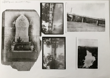
The Bryan family live din Princess Street, Kew.Photocopies of original photographs relating to or that belonged to the Bryan Family of Princess Street, Kew. The images include the headstone of Sarah Bryan and Anne Chambers; three photos of floods in Kew, one dated 1931; and a view of the River Yarra. bryan family (kew), kew -
 Kew Historical Society Inc
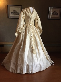
Clothing - White Silk Wedding Dress, c.1869
Joseph Butterworth COOMBS (1842-1901), was an accountant who founded a successful mercantile trading company. At the time of his marriage to Caroline Mary MICHEL in 1869, Coombs had already purchased ten acres of Studley Park. The acreage included land on the west of Fenwick Street that extended along lower Stawell Street to the corner of Yarra Street, all of it connected directly to the Yarra environs. A right of way to Studley Park Road was on the title, though Coombs went on to purchase more land, some of which faced Studley Park Road. In addition to owning the Studley Park acreage, Coombs later acquired 1,201 acres of land abutting the Acheron River. While retaining the Kew property he became a Taggerty Councillor and was Shire President for a time. J.B. Coombs died at Acheron Station in 1901 (aged 59 years). A few months after, tenders were called to repair the Kew dwelling, the Fenwick Street property now appearing in records with the name ‘Hope Mansell’. Caroline Coombs remained at Hope Mansell until she died in 1924, survived by three sons and five daughters. Not long after her death, advertisements appeared for the sale of the Studley Park land. The sale seems to have been a mechanism for distribution of the Estate, as the following year the original ten acre holding was transferred to members of the family. The eldest daughter Mabel married William Younger who, with his brother Alexander, developed Younger and Mackie Courts, both south of Studley Park Road. [Research: Kerry Fairbank]In 1961, the granddaughter of Joseph and Caroline Coombs, Mabel Isola (Younger) Grattan, donated ten 19th century dresses and parasols to the Kew Historical Society. The costumes, now known as the 'Coombs Collection', were the earliest recorded items of clothing to enter the Society's collection. Each of the items in the Coombs Collection, of which this item forms a part, is historically, aesthetically and socially significant. As a collection, the costumes includes outstanding examples of morning wear, day dresses, wedding dresses, and clothing accessories, providing evidence of outstanding dressmaker skills in Victoria during the mid to late Victorian period. Two-piece white silk wedding dress comprised of a short tailored bodice and a bell shaped skirt. The most prominent feature of the bodice is the wide pagoda sleeves, with false undersleeves of muslin. The edge of the sleeves includes small posies of orange blossom. Separate panels of lace, dropping from the waist are the only form of decoration on the skirt. The round high neckline was later converted to v-line in the 19th century.coombs collection, women's clothing, australian fashion, fashion & design collection, costumes, wedding dresses