Showing 11129 items
matching planning
-
 Ringwood and District Historical Society
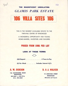
Flyer, Land Sale Brochure, Glamis Park Estate (Wantirna, Vic.) - 1959
Street name Carnarvon Avenue on the subdivision plan became Selkirk Avenue at some stage during or subsequent to development of the Estate.Bi-folded advertisement for sale of residential allotments, including summary of subdivision features and local facilities.Subdivision includes Wantirna streets - Wantirna Road, Carnarvon Avenue, Inchcape Avenue, St Thomas Avenue, St Davids Drive, Dudley Avenue, Angus Avenue. Agents - A.W. Dickson, 136 Whitehorse Road, Ringwood, Telephone WU 6007, WU 7016, A.H. WU 6868. D. & J. Walker, 18 Junction Street, Ringwood, Telephone WU 6516 (all hours). -
 Eltham District Historical Society Inc
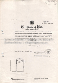
Document - Property Binder, 727 Main Road, Eltham
Copy Certificate of Title, plan of subdivision Part of Crown Portion 12 Section 4 Parish of Nillumbik County of Evelyn.main road, eltham, property, houses, shops, businesses -
 Glen Eira Historical Society
Map - Orienteering
This file contains one item. A map/plan of the Bentleigh East Running Roulette for the Monday series on 21/03/2011.bayside kangaroos orienteering, bentleigh east, sedunary vic, leicester paul, sheahan jenny, clubs, sheahan john, tamblyn greg, centre road bentleigh, tucker road bentleigh, south road moorabbin, associations, nepean highway, bentleigh rsl club, orienteering, sports, recreations -
 Greensborough Historical Society
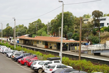
Photograph - Photograph - Digital Image, Marilyn Smith, Greensborough Railway Station 2021, 2021_02
Photographs of Greensborough Railway Station in February 2021, before the planned rebuild of the station as part of the Hurstbridge rail line upgrade. 3 Colour digital photographsgreensborough railway station, hurstbridge rail line upgrade -
 Greensborough Historical Society
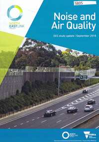
Pamphlet, Victorian Government, Noise and air quality: ESS Study Update, 2018_09
Part of the Environmental Effects Statement for the North East Link planning approval process. This volume covers noise and air quality.6 p., col. photographsnorth east link -
 Greensborough Historical Society
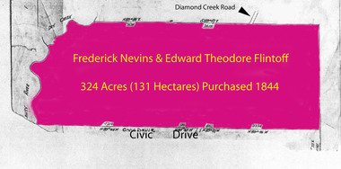
Folder of documents, Flintoff - various documents, 1844_
Records the Flintoff family's ownership of parcels of land in the Greensborough area. Includes a survey plan for acquisition of land for the aqueduct 1897.Various photocopies of title documents relating to land owned by the Flintoff family in Greensborough.Mainly handwritten documents dating from early 20th century.flintoff family, land titles, greensborough, aqueduct -
Tatura Irrigation & Wartime Camps Museum
Document, Sketch plan of Tatura
Sketch plan of Tatura showing names of occupiers of buildings 1n 1904. Possibly drawn by James Reilly from memory.Ink outlines on white paper. -
 Robin Boyd Foundation
Document - Manuscript, Robin Boyd, Australia Square, 1969
Discusses Australia Square in Sydney; its plan, structure, materials and artworks (tapestries and sculptures by Le Corbusier, Vasarely and Calder).Original manuscript of an article published as 'Australia Square: Circle in the Square' in "Architectural Forum", Vol. 130, No.3, April 1969, pp.26 - 35.Typewritten (c copy), quarto, 4 pagesaustralia square, sydney, harry seidler, plaza, pier luigi nervi, tapestry, sculpture, le corbusier, vasarely, calder, robin boyd, manuscript -
 Robin Boyd Foundation
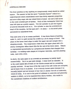
Document - Manuscript, Robin Boyd, Two Symbols of Canberra, 1964
Boyd discusses the future planning of two major symbolic national buildings - Parliament House and the National Centre (an arts centre).Original manuscript of an article published as 'Symbol City' in The Australian on 28.11.1964.Typewritten (c copy), quarto, 5 pagescanberra, parliament house, national centre, chandigarh, brasilia, robin boyd, manuscript, national capital -
 Robin Boyd Foundation
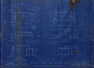
Drawing - Architectural, Robin Boyd, Timber Frame Studio for Mr Arthur Boyd: Murrumbeena, 1938
Project: Timber Frame Studio for Mr Arthur Boyd: Murrumbeena, two drawings, plan and section. drawn by Robin Boyd.Working Drawing, Blueprint -
 City of Kingston
Pamphlet - Black and white, Robert McCamish & John Gilpin (Vendors), For Private Sale Station Entrance Estate, Highett, 1930s
Sales plan for land in the suburb of Highett, bounded by Wickham Road, Railway Parade, Highett Road and Point Nepean Street. The developing urban area of Highett within the City of Kingston. This land sale pamphlet illustrates the subdivision of land within the municipality and the changing demographic of the district as new houses are constructed. The extension of the railway line from the city to Mordialloc opened up the land for development.Black and white pamphlet advertising for private sale the Station Entrance Estate, Highett. Incorporates a map of the estate bordered by Wickham Road, Railway Parade, Highett Road and Point Nepean Road. Handwritten in black ink on reverse: Station Entrance / Estate / Late [indecipherable]highett, land sales, estate -
 City of Kingston
Pamphlet - Colour, Fergusson & Mitchell Lith, Sandringham Rises, c. 1888
Sales plan for land in the suburb of Sandringham, bounded by Bluff Road, Bay Road and William Street, and incorporating Frances Street.The developing urban area of Highett (then called Sandringham) within the City of Kingston. This land sale pamphlet illustrates the subdivision of land within the municipality and the changing demographic of the district as new houses are constructed close to infrastructure.Colour pamphlet advertising for sale 35 lots in Sandringham Rises, Sandringham. Incorporates a map of the estate bordered by Bluff Road, Bay Road and William Street, including Frances Street.Handwritten in grey pencil next to the words 'THREE O'CLOCK': 1888 Handwritten in blue ben next to the words '& BUSINESS SITES': 1888land sales, sandringham, highett -
Bialik College
Documents, Construction of building on the Auburn Road campus, c. 1980s, 1980s
Plans for the construction of a building on the Auburn Road campus, c. 1980s. Please contact [email protected] to request access to this record.development -
Clunes Museum
Document - CONSERVATION STUDY, RICHARD AITKEN, 1986
REPORT FOR THE SHIRE OF TALBOT & CLUNES 'AUSTRALIAN HERITAGE COMMISSION'& MINISTRY FOR PLANNING & ENVIRONMENT, BY RICHARD AITKEN - 10TH APRIL, 1986TALBOT AND CLUNES CONSERVATION STUDY - HISTORY OF SIGNIFICANT BUILDINGS.local history, document, report, hepburn shire -
 Lakes Entrance Historical Society
Photograph - Golf Houses residential development Golf Links Road Lakes Entrance Victoria, Lakes Post Newspaper, 1/12/1999 12:00:00 AM
Golf Houses residential development Golf Links Road Lakes Entrance Victoria - Proposed plan shown on notice boardColour photograph showing Matt Martino Bill Daniel Mike Hurst and Gary Jeal at the launch of Golf Houses residential development Golf Links Road Lakes Entrance Victoriatourism, land development -
Glen Eira Historical Society
Document - Glentana
Two pages of handwritten research notes, undated and unattributed, on the property Glentana at 503 Glenhuntly Road, Elsternwick. The notes include a description of the features of the house and a short list of the early owners of the property from 1885 to 1904. The file also includes an unattributed hand drawn draft floor plan of Glentana and a final unattributed hand drawn floor plan of Glentana dated 11/01/1973.glentana, glen tana, glenhuntley road, gavan-duffy family, gowenlock david, stewart d, grimwood samuel, gavan-duffy frank, lindsay, webb charles, elsternwick, glen huntly road, glenhuntly road -
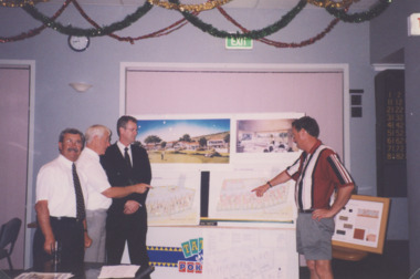
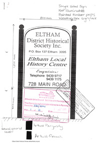 Eltham District Historical Society Inc
Document - Folder, Application for a street sign, 1999-2000
Folder 67 of the Harry Gilham Collection. Folder includes information and some duplication relating to the installation of a sign in front of 728 Main Road, Eltham by Eltham District Historical Society. Includes newsletter no 138, design of sign and related wording on sign, quotation by John Sharp Signs, Eltham, notes and planning permit submitted to Nillumbik Shire Council, and associated plans 1999-200030 pages in manilla foldereltham district historical society, planning permit, signage, john sharp signs, local history centre -
 Orbost & District Historical Society
photographs
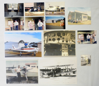
Orbost Aero Club began in 1969 with Basil Dowie as Chair, David Nixon as Secretary/Treasurer. The group went into recess from 1977-1991 closing in 1997. The mid 1960s were boom years in flying training in Australia and the number of Aero Clubs grew rapidly. The Club played a significant role in the establishment of the small airport at Marlo and in the ongoing operation and development of the airport over the years particularly for patient transfer by aerial ambulance. The Orbost Aero Club Club played a significant role in the establishment of the small airport at Marlo and in the ongoing operation and development of the airport over the years.Thirteen photographs related to the Orbost aero Club. Most are coloured. Ten are originals. 2406,33 is of David Nixon in the cockpit of the Bonanza (a small Beechcraft plane). 2406.40 is a photograph of David Nixon's grandfather's desk used for planning flights etc.On back of 2406.33 in blue pen - "This is me in the cockpit of the Bonanza." On back of 2406.34 in blue pen - "Taking Cora for her first flight with me after gaining my pilot's licence 1966."orbost-aero-club nixon_david -
 Warrnambool and District Historical Society Inc.
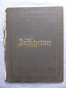
Book, Architecture, 1870s
This book belonged to John William Crawley an engineer, architect and surveyor who was appointed District Engineer for the Public Works Department in the Western District in 1866. He was the Shire of Warrnambool Engineer from 1874 to 1895 when he was succeeded by his son. This book is of minor importance as a memento of John William Crawley an important engineer in the Shire of WarrnamboolThis is a hard cover book with pages containing architectural plans,designs and printing. Some of the pages are blank.The cover is faded and spotted and has a gold title The spine is damaged .Inside the front cover is an inscription and on the following page is another inscription.J.W Crawley 1879 Architecture john william crawley, shire of warrnambool -
 Glenelg Shire Council Cultural Collection
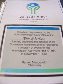
Certificate - Sesquicentenary Certificate, 1985
Displayed at History House. Portland's Sesquicentenary. Portland City Council.Certificate with "Victoria 150" logo at top. In a black-boxed square in lower two-thirds of paper is certificate endorsing the activities of the Town of Portland's planning committee for events of Anniversary Year November 17, 1984 - November 11, 1985.Front: Signature of Ranald Macdonald, Chairman (lower centre, faded pen). -
Glenelg Shire Council Cultural Collection
Document - Invitation - to assist Portland's 150th Anniversary Committee, c. 1984
Invitation to become a patron to financially assist Portland's 150th Anniversary Committee to confirm all planned activities for the celebrations. White card, blue print. 150th logo in blue, on front. Detachable section inside, application for membership form.portland 150th anniversary, vivian family records -
 Federation University Historical Collection
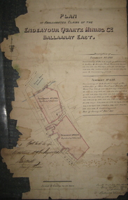
Plan, Plan of the Endeavour Quartz Mining Co., Ballarat East, 1874, 04/01/1874
Hand drawn and coloured paper plan relating to the Endeavour Quartz Mining Co. and tenements 634 and 546. The tenements were along Main Road and Eureka Street in close proximity to the Barkly Street and the Ballarat East Town Hall.ballarat east, endeavour quartz mining co, mining, plan, cgt -
 Federation University Historical Collection
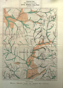
Book, Report on the Little Bendigo or Nerrena Gold-Field, Ballarat, 1901, 1901
Blue soft covered foolscap book of 4 pages. The book includes a folded, colour contour plan shewing reefs and Surface Works Little Bendigo Gold Field and an Underground Survey of Mines, Metropolitan, Monte Cristo Linelittle bendigo, nerrena, h.s. whitelaw, william baragwanath, geology, monte christo, monte cristo, neerena, nerrina, plans, mining cgt -
 Bendigo Historical Society Inc.
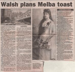
Newspaper - JENNY FOLEY COLLECTION: HERALD SUN
Sunday Herald Sun from December 17, 2000. Article by Jim Murphy on Mike Walsh plans to rename Exhibition Street, Melba Boulevard or Melba Avenue and erect a statue to honour Dame Nellie Melba. The clip is in a folder.newspaper, herald, article -
 Bendigo Historical Society Inc.
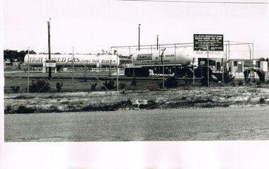
Photograph - CASTLEMAINE GAS COMPANY COLLECTION: PHOTO GOLDEN SQUARE DEPOT
L.P.G. Plan Gas and fuel Corporation of Victoria '' Golden Square Gas Plant'' Tank of ''High Speed Gas heat that obeys you '' at centre left side and a brambles baulk haulage truck at centre right.. Date Unknownorganisation, industry, gas and fuel -
 Bendigo Historical Society Inc.
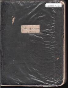
Book - HARRIS COLLECTION: NOTES OF LESSONS: J HARRIS
Hard black cardboard covered Exercise book entitled : ''Notes of Lessons - J Harris'' Handwritten teacher's lesson plans 1929 with mention of two schools - Lee Street and Rathdowne Street. Has Index of Lessons at front of book.person, individual, j. harris, lee street, rathdowne street. -
 Bendigo Historical Society Inc.
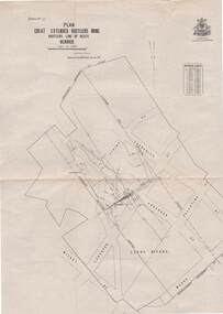
Map - STRUGNELL COLLECTION: HUSTLER'S LINE OF REEFS, BENDIGO, September 1913
Map, Hustler's Line of Reefs, Great Extended Hustler's Mine Plan,Plate No X (10).Bulletin No 33 Signed H.A.Whitelaw Underground survey Office Bendigo September 1913 Drawing has a table showing depths of levelsUnderground Survey Office, Bendigo.map, bendigo, great extended hustler's mine -
Port Melbourne Historical & Preservation Society
Document - MMBW re proposed canopy, Bay Garage, Bay Street, Port Melbourne, The Shell Company of Australia Limited, 1964 - 1965
Melbourne and Metropolitan Board of Works (MMBW) documents referring to the Bay Garage, Bay St, Port Melbourne and a proposed new canopy. .01- letter dated 25 March 1965 .02 - plans dated 6 November 1964built environment - commercial, transport - motor vehicles, mmbw, the shell company of australia ltd, melbourne and metropolitan board of works -
Port Melbourne Historical & Preservation Society
Plan - Setting temporary gangway at Inner East berth Station Pier for Tasmanian ferry Abel Tasman, Engineering Division, Port of Melbourne Authority, 1984
Plan: cross section at passenger doors showing deck levels - ship empty highest allowable tide (Drawing used in the setting up of temporary gangway at the Inner East berth of Station Pier for the vessel Abel Tasman) 1984melbourne harbor trust - port of melbourne authority, piers and wharves - station pier, abel tasman -
Port Melbourne Historical & Preservation Society
Plan - Setting temporary gangway at Inner East berth Station Pier for Tasmanian ferry Abel Tasman, Engineering Division, Port of Melbourne Authority, 1984
Plan: cross section at passenger doors showing deck levels - ship full lowest allowable tide (Drawing used in the setting up of temporary gangway at the Inner East berth of Station Pier for the vessel Abel Tasman), 1984melbourne harbor trust - port of melbourne authority, piers and wharves - station pier, abel tasman