Showing 10395 items
matching plan
-
 Lakes Entrance Regional Historical Society (operating as Lakes Entrance History Centre & Museum)
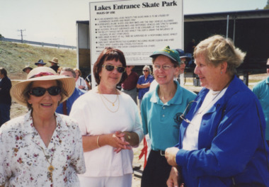
Photograph, Lakes Post Newspaper, 2000
number in album 03587.02Colour photograph opening of Skateboard Park, ladies Beryl Young, Pam Dingwall and Heather Bury of Metung Bloodhounds, with Lions Lady Sylvia Stroud, supporters of the Skatepark Planning Committee. Lakes Entrance Victoriasports, construction -
 Port Melbourne Historical & Preservation Society
Photograph - Main drain reconstruction, Cruikshank Street, Port Melbourne, Outfall Timber Drain Reconstruction, 23 Aug 2004
Photographs & plans supplied by Melbourne water of Cruikshank Street main drain reconstruction of bay outfall. 2004 .01 19x25 colour photo of clear spanning footing .02 19x25 colour photo of outer edge of drain .03 19x25 colour photo of top deck of drain .04 19x25 colour photo of excavation .05 - .08 19x25 colour photo of excavation of drain .09 - .12 colour photo of excavation of drain .13 - .14 22x33 colour photo of plan of area .15 - .17 39x53 drawn plan of area surrounding .18 - .19 39x53 Cruickshank St main drain reconstruction .20 Initial e-mail letter regarding drain (3-8-04) .21 Business card, Melbourne Water's Paul Balassomeengineering - canals and drainage, cruickshank street -
 Melbourne Tram Museum
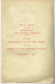
Document - Report, Metropolitan Town Planning Commission, "Metropolitan Town Planning Commission - Darling to Glen Waverley Railway - 1927", May. 1927
Report - 20 pages + 5 Maps stapled and then glued bound within a light green grey light card folder titled "Metropolitan Town Planning Commission - Special Report on the Development of the area serviced by the Darling to Glen Waverley Railway - 1927". Report looks the development that could be undertaken along the proposed Glen Waverley rail line, its town planning, Garden City type layouts, rail level crossings, new arterial roads, open spaces, financial arrangements, sewerage and water supply, zoning, legislation and conclusion. Dated 6/5/1927. Plans show possible garden city type layouts, arterial roads, possibilities within existing sub-divisions. Note that Mr. Strickland was a member of the Commission undertaking this work.Has in ink on the bottom edge "17th June 1919"trams, tramways, mmtb, tramways, development, town planning, glen waverley, darling -
Melbourne Tram Museum
Newspaper, The Herald, “New trains, trams hope”, 5/10/1971 12:00:00 AM
Newspaper clipping titled: “New trains, trams hope” – Herald Tues 5/10/71 Photo and text of new tram Experimental new colours, orange, yellow, green Passengers will board through the front door and leave through the centre exit. Driver separated from passengers by a low bulkhead and rails, same style as buses. Conductor will be seated at front entrance. Trams will be heated. Acting chairman of Tramways Board, F D Snell said plans for new trams were complete. “Ready to go as soon as we get the money”. Tram fleet of 700 is planned to be replaced by 600 of improved version. About 900 new trams will be needed by 1985 according to Metropolitan Transport Plan. Each new tram is expected to cost about $65,000.trams, tramways, new trams, livery, metropolitan transport plan, prototype tramcar, 1041, tram 1041 -
 Melbourne Tram Museum
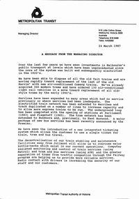
Document - Notice, The Met, "MTA Business Planning Report No. 1 - Analysis of the Existing situation", 24/03/1987 12:00:00 AM
Set of two A4 documents about the future and current situation or status of the Metropolitan Transit Authority of Victoria (The Met). .1 - A3 folded sheet, titled "A message from the Managing Director" signed by Kevin Shea, dated 24/3/1987 setting out the current situation, changes, services, Jolimont, new tram lines, ticketing, vehicles and future planning. Business Plan released the same day by the Minister Tom Roper. .2 - 12 A4 pages - centre stapled printed on orange paper, titled "MTA Business Planning Report No. 1 - Analysis of the Existing situation" - setting out the policy context, goals and objectives, international perspective, patronage and service levels, fares system, human resources, capital investment, financial performance, changing environment, key issues and next stepstrams, tramways, the met, planning, reports, finances, railways, new trams, new track -
 Kiewa Valley Historical Society
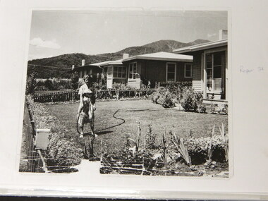
Folder - Early Photos of Mt Beauty
Mt Beauty township was built during the 1950's to house the employees of the State Electricity Commission working on the Kiewa Hydro Electric Scheme. After the completion of the Kiewa Hydro Electric Scheme many houses were sold and the public buildings handed over to the Alpine Shire. Mt Beauty has always been a tourist destination especially with its proximity to the ski fields at Falls Creek.This folder contains many early photos of Mt Beauty showing the construction town during its development during the Kiewa Hydro Electric Scheme and its early days of tourism. A3 size black plastic folder with clear plastic sleeves holding early black & white photos of Mt Beauty township. Also included are: 1. 3 foolscap pages -Nov., 1953 Kiewa Hydro-Electric Scheme Progress. 2. SECV Drawing Plan (No. K6242) of Mt Beauty House - 3 angles and floor plan, English Pre-cut Type 3B.ILA with note that all houses with prefix 3B are similar. 3. Orange, black and white pamphlet "Welcome to Kiewa" 4. Tourist postcard 'fold-up' of 11 postcards "Mt Beauty and the Kiewa Scheme, Victoria 5. Drawing Plan of 'Mt Beauty Housing. Use of Prefabricated Cubicles for Houses. Type C.1 6. Drawing Plan of 'Kiewa Scheme Mt Beauty Housing Type "G". 7. 5 pages on "Twelve Tips on Caring for Old Buildings 8. Booklet advertising Mt Beauty housing for sale including activities available in the area. (1960's) 9. List of Photos from SECV held by KVHS Some photos have handwritten labels mt beauty. secv. kiewa hydro electric scheme.tourism. housing. construction town. falls creek. -
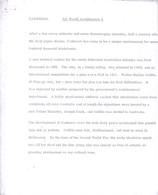 Robin Boyd Foundation
Document - Manuscript, Robin Boyd, Canberra, 1967
Boyd outlines the history of Canberra's design and construction. He argues that Canberra's strength is its planning and axially-based landscaping, but that it lacks the buildings which make the Le Corbusier's Chandigarh interesting. Boyd is highly critical of Chandigarh as an urban environment and concludes that for non-architects, planning and connection to nature is more important than buildings.Original manuscript published as 'Canberra Master Plan: Walter Burley Griffin' in World Architecture 4, John Donat (ed.), Viking Press 1967, pp 202-205.Typewritten (p/copy), quarto, 6 pageswalter burley griffin, canberra, john overall, lake burley griffin, oscar niemeyer, le corbusier, chandigarh, city beautiful, garden city, urban planning, robin boyd, manuscript -
Mission to Seafarers Victoria
Letter - Correspondence, 02/02/1951
This letter contains news of mutual friends. Allan plans to leave London for a few months in Oslo.Quinn CollectionA four-page letter written in green ink on one sheet of buff coloured paper folded in book form (0858.a) headed London and dated 02/02/51. Letter is from Allan to his mother. No envelope has been found.letters-from-abroad, allan quinn, london, pat charlton, mr hayes -
Greensborough Historical Society
Leaflet, Road changes: Greensborough and Watsonia March 2019, 2019_03
Outline of proposed changes to the plan for roads around the Old Greensborough Road and Watsonia Station areas1 p. leaflet printed in colour both sides north east link, watsonia station, old greensborough road watsonia -
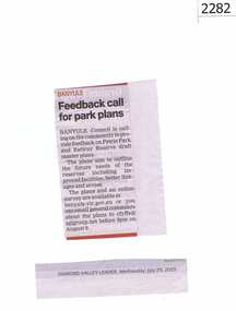 Greensborough Historical Society
Newspaper clipping, Feedback call for park plans, 29/07/2015
Banyule Council asked for community feedback on the draft master plan for Petrie Park and Rattray Reserve.News clipping, black text.montmorency, petrie park, rattray reserve -
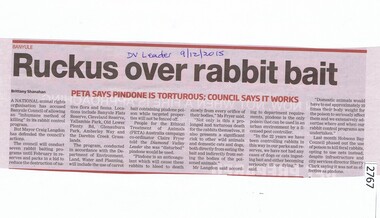 Greensborough Historical Society
Newspaper Clipping, Ruckus over rabbit bait, 09/12/2015
Animal rights group PETA objected to Banyule Council's plan to bait rabbits using Pindone.News clipping, black text, colour image. rabbits, peta, banyule city council -
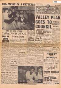 Greensborough Historical Society
Newspaper, Elliott Provincial newspapers Pty Ltd, Diamond Valley Mirror May 4, 1965, 04/05/1965
Contains article "Valley plan goes to Council", discussing the development of the Plenty Valley, north of Greensborough.Early plan submitted to Diamond Valley Council in 19658 p.greensborough -
 Greensborough Historical Society
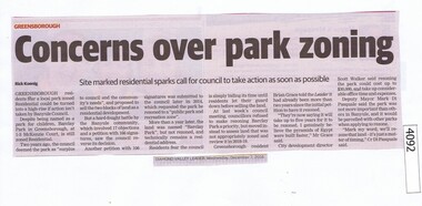
Newspaper Clipping, Diamond Valley Leader, Concerns over park zoning, 07/12/2016
Barclay Park in McKenzie Court Greensborough is still zoned residential with rezoning planned for 2018-19.News clipping, black text. barclay park, mckenzie court greensborough -
 Greensborough Historical Society
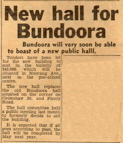
Newspaper Clipping - Digital Image, New hall for Bundoora, 21/11/1967
News of the planned sale of the old Bundoora Hall and building of a new Hall in Noorang Avenue in 1967.Digital copy of newspaper clipping.bundoora public hall, bundoora -
 Whitehorse Historical Society Inc.
Postcard, Christmas Card from Mary to Cissie, 21/12/1913
Photocopy of Christmas Card from Mary and Emil to Cissienon-fictionPhotocopy of Christmas Card from Mary and Emil to Cissiejackschowsky mary, schwerkolt francesca, jackschowsky emil -
 Lakes Entrance Regional Historical Society (operating as Lakes Entrance History Centre & Museum)
Photograph, 1912 c
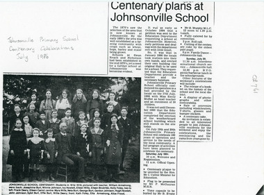
Newspaper article outlines activities planned for Johnsonville Primary School Centenary Celebrations July 1986.Black and white photocopy of newspaper article with photograph of twenty two children with teacher William Armstrong of J Primary School Johnsonville Victoriaschools -
![Vital Connections: Melbourne and its Board of Works 1891-1991 / [by] A.E. Dingle](/media/collectors/550653872162f11fb04854aa/items/5ece65f9f36c2704c4f2b67b/item-media/5ece66eef36c2704c4f2b783/item-fit-380x285.jpg) Kew Historical Society Inc
Kew Historical Society IncBook, A.E. Dingle, Vital Connections: Melbourne and its Board of Works 1891-1991, 1991
Ringwood, Vic. : McPhee Gribble, 1991 432 p. : ill. (some col.), maps, ports. ; 25 cm. non-fictionmelbourne and metropolitan board of works -- history., melbourne (vic.) -- public works -- history., cartography -
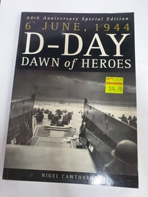 Clayton RSL Sub Branch
soft cover non-fiction book, Arcturus Publishing, 6 June 1944 D-Day Dawn of Heroes, 2004
Tells the story of Operation Overlord, the largest most meticulously planned seaborne invasion in the history of warfare.soft cover non-ficton book -
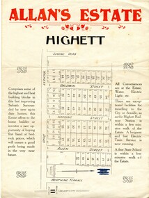 City of Kingston
Pamphlet - Colour, Allan's Estate Highett, 1930s
Sales plan for land in the suburb of Highett, bounded by Spring Road, Highett Road and Worthing Terrace.The developing urban area of Highett within the City of Kingston. This land sale pamphlet illustrates the subdivision of land within the municipality and the changing demographic of the district as new houses are constructed.Colour pamphlet advertising Allan's Estate, Highett. Incorporates a map of the estate bordered by Spring Road, Highett Road and Worthing Terrace.Handwritten in grey pencil on reverse: Allan's Estate / Highett Crossed out in blue pencil on front: Name and address of what appears to be a solicitorhighett, land sales, estate -
 City of Kingston
Pamphlet - Black and white, Stott & Burke, Highland Estate Bentleigh, c.1915
Sales plan for land in the suburb of Bentleigh, along Collins and Ross Streets, bounded by Jasper Road.The developing urban area of Bentleigh within the City of Kingston. This land sale pamphlet illustrates the subdivision of land within the municipality and the changing demographic of the district as new houses are constructed.Black and white pamphlet advertising for private sale the Highland Estate, Bentleigh. Incorporates a map of the estate between Collins St and Ross St, bordered by Japser Road. Handwritten in grey pencil on map: additional subdivisions numbered 15-19 drawn along Ross St Handwritten in grey pencil on map: indecipherable annotations to subdivisions 1, 3 and 14land sales, bentleigh, estate -
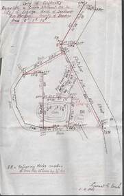
Tarnagulla History Archive
Set of Maps (Mining & Local Area), various
David Gordon Collection. A set of mining documents, maps and plans: 1. Dunolly Deep Leads - showing location and names of deep lead gold deposits in region around Dunolly including at Tarnagulla and Newbridge. Geological Survey of Victoria, Department of Minerals and Energy. Bulletin No. 62, Map No. 4 Dunolly (770 x 485 mm). 2. Poseidon Lead (Facsimile) 3. Nick O Time Lead (Facsimile) 4. Happy Go Lucky Mine prospectus and plan (colour copy) 5. Jones Creek GM Co. (Raven & Gourlay's) Waanyarra - Prospectus (colour copy) 6. Poseidon Area Plan (colour copy) and Poseidon Area map (B&W copy). 7. Cross-section diagram of Spread Eagle Reef 8. New Birthday Gold Mine - area map (colour copy) and mine cross-section ( (colour copy). 9. Cross section of Poverty Reef, by Department of Mines (B&W copy, 2 parts on A2 paper) 10. Time-Lease Graph for Watts Reef, Specimen Reef, Stony Reef, Poverty Reef (second page in detail), created by Eric WIlkinson for Ref Mining NL, 1995 11. 1859 Plan of the Gold Workings & Township of Sandy Creek, Shewing the Mining Leases, Extended Claims & Machinery by R.J. McMillan, Mining Surveyor (B&W copy) 12. Longitundinal and Transverse Vertical Sections of Poverty Reef, Sandy Creek 1859, by R.J. McMillan, Mining Surveyor (B&W copy) 13. Tarnagulla Locality Plan (B&W copy) 14. Universal Grid Reference Map (Topographic) for Laanecoorie North (2 copies) 15. Universal Grid Reference Map (Topographic) for Inglewood South 16. Poverty Reef, Plan showing shafts and early tenements, created by Eric WIlkinson for Ref Mining NL, 1995 17. Locality Map of mining leases in Tarnagulla 18. Plan and Elevation of part of Poverty Reef, Sandy Creek, showing the claims and positions of the shaft. by R.J. McMillan, Mining Surveyor (Facsimile, composed of taped together components) 19.Plan and Elevation of part of Poverty Reef, Sandy Creek, showing the claims and positions of the shaft. by R.J. McMillan, Mining Surveyor (Facsimile, composed of taped together components) -
Glen Eira Historical Society
Plan - St Patrick’s Roman Catholic Church, Murrumbeena
There is a photocopy of the commemorating booklet for the blessing and opening of St Patrick’s Memorial Catholic Church Murrumbeena on 15 August 1963. It also includes a brief history of the parish, a plan of the church and a sketch of the church exterior. Second there is an unattributed undated research note of the memorial stones for St Patrick’s Catholic Church and school Murrumbeena. Third is an unattributed, undated handwritten notes on St Patrick’s School buildings regarding teaching sisters and dates when additional classrooms were built. The fourth document is a six page brochure seeking donations from parishioners to commence on 10/04/1966. It includes the church’s financial statement, a picture of the church exterior as the cover and two photographs of the reverends. Inside the booklet.glen huntly, religious services, tweedy e. v, cremin patrick rev., murrumbeena, fox bishop, parish, north road, ellis robert o, clergy, malvern east, memorials, parish of ormond, east boundary road, dalny road, rovira william rev, quillinan james rev, church furniture, murrumbeena road., memorial stone, mannix daniel archbishop, pollard k, catholic church, m.p arbory and co., st patrick’s roman catholic church murrumbeena -
 Bendigo Historical Society Inc.
Plan - MCCOLL, RANKIN AND STANISTREET COLLECTION: PLAN OF SURVEY OF DAM SITE, 1941
McColl Rankin & Stanistreet, Plan of Survey of Dam site, Part of Crown Allotment 98 Section C, City of Bendigo, Parish of Sandhurst, County of Bendigo. Signed by Garnet G Birch 1 Feb 1941. 33.5 x 43. Attached is a Copy of Field notes, Dam Site in Crown Allotment 198 Sec. City of Bendigo, Parish of Sandhurst. True Meridian, County of Bendigo, Area 0A 1R 16P. Signed Garnet G Birch, 1/2/1941. Drawn in red and black pen. 20.8 x 33. Both maps are for Deborah Extended Gold Mining Co. No Liabilityorganization, mining, deborah extended gold mining co nl, mccoll rankin & stanistreet, plan of survey of dam site -
Bendigo Historical Society Inc.
Plan - SANDHURST BOYS CENTRE COLLECTION: PART DETAIL SURVEY
Prepared by the Public Works Department for the Government of Victoria. Client is the Mental Health Department, Municipality is City of Bendigo. Site plan of area bounded by O'Dwyer St and Finn St, North Bendigo. Handwritten note on back - Update of whole centre 10/4/91. Details include: oval, tennis court, grandstand, area is bounded by an un-named watercourse. Also indicated are 14 nissen huts, 2 toilet blocks, 3 weatherboard buildings, 1 galvanised iron building,2 galvanised iron sheds (one new), residence, garage, fowl shed, and a carpark. Location unknown 16.02.2023.bendigo, institutions, sandhurst boys centre, sandhurst boys centre site plan; -
University of Melbourne, Burnley Campus Archives
Plan, Royal Children's Hospital, 1989-1991
(1) Landscape Concept Royal Children's Hospital by Bates Smart and McCutcheon. (2) Tracing paper Sketch Plan. Scale 1:250 dated 29.3.90 by Jill Kellow. (3) Garden Project, The Foundation Royal Children's Hospital by Denise L. Stephens, DLS Design. Sheet 6 of 7, May 1990. Scale 1:100. (4) Photocopy of Surfaces and Playground Equipment, Royal Children's Hospital, August 1991. No 9046/01. Scale 1:100. (5) Photocopy of Surfaces and Playground Equipment, Royal Children's Hospital, August 1991. No 9046/02. Drawn By R.K. Scale 1:100.royal children's hospital, bates smart, jill kellow -
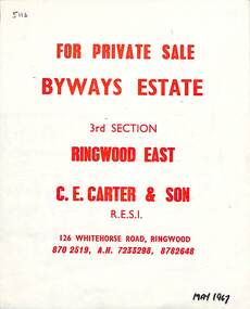 Ringwood and District Historical Society
Flyer, Land Sale Brochure, Byways Estate Ringwood East - 3rd Section released 1967
Refer also to Reg. No. 5110 for Byways Estate 1965 release, and Reg. No. 5114 for Byways Estate 1970 release.Double-sided real estate notice showing subdivision location with street and property layout, with separate A4 typewritten price listSubdivision plan includes Byways Drive, Buronga Avenue, Hender Street, Lester Avenue and Jess Court. (Agent) C.E. Carter & Son R.E.S.I. 126 Whitehorse Road, Ringwood (Telephone) 870 2519, A.H. 723 3298, 878 2648 -
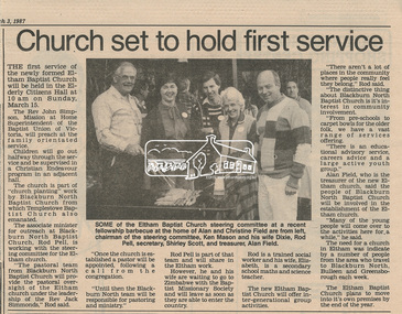 Eltham District Historical Society Inc
Newsclipping, Church set to hold first service, Diamond Valley News, 3 March 1987, 3 Mar 1987
Story on foundations of the Eltham Baptist Church and plans to move into new facilities by the end of 1987 (in Nyora Road).Digital file only - Digitised by EDHS from a scrapbook on loan from Beryl Bradbury (nee Stokes), daughter of Frank Stokes.beryl bradbury (nee stokes) collection, eltham baptist church, senior citizen's hall -
 Greensborough Historical Society
Business card, Watsonia Physiotherapy, Greensborough Investment Advisors 2018, 2018
Business card for a local financial planning business, Greensborough Investment Advisors, at 367 Greensborough Road, GreensboroughBusiness card, white card with blue text.financial planners, investment advisors, greensborough investment advisors, greensborough road greensborough -
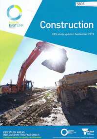 Greensborough Historical Society
Pamphlet, Victorian Government, Construction: EES study update, 2018_09
Part of the EES Study update for planning approval process for the North East Link. This volume covers Construction.6 p., col. photographsnorth east link -
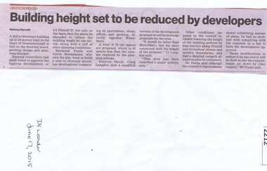 Greensborough Historical Society
Newspaper clipping, Building height set to be reduced by developers, 17/06/2015
A proposed development at 4-6 Flintoff Street is to have its plans amended to reduce the height of the building.News clipping, black text.flintoff street greensborough, town planning, banyule city council