Showing 173744 items matching "1200-mair-street"
-
 Stawell Historical Society Inc
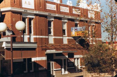
Photograph, Bull & Mouth Hotel in Main Street Stawell c1985
Bull & Mouth Hotel Main Street Stawell Built 1907. c1985 stawell streetscape -
 Stawell Historical Society Inc
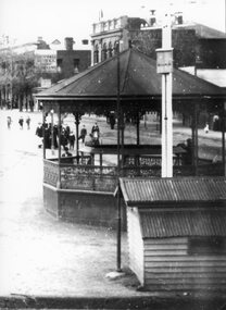
Photograph, First building used for the Weighbridge in Lower Main Street near the Rotunda
First building for Weighbridge of Weatherboards in Lower Main Street near Rotunda. stawell transport -
 Stawell Historical Society Inc
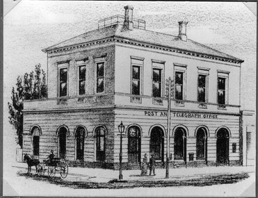
Drawing, Post Office in Main Street Stawell from the P.C. News Supplement 1888 -- Sketch
Post Office Main Street. From P.C. News Supplement 1888stawell businesses -
 Stawell Historical Society Inc
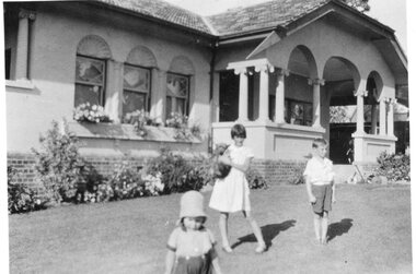
Photograph, Bennet family home at 51 Smith Street Stawell with Children in the foreground
Bennet family home 51 Smith Street with Bennet children in foreground stawell industry -
 Stawell Historical Society Inc
Photograph, First Stawell Police Station Lockup site in Clemes Street -- Coloured
Colour Photo Clemes Street site of First Police Station Lockupstawell -
 Stawell Historical Society Inc
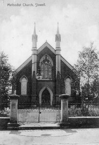
Photograph, Stawell Methodist Church in Main Street Stawell -- Postcard
Stawell Methodist Church. Main Street Stawell. Original Post Card. stawell -
 Stawell Historical Society Inc
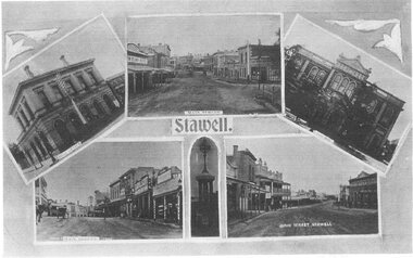
Postcard, Main Street showing area in front of Town Hall Hotel c 1940 -- 2 Photos -- Postcards -- 1 Coloured
Main Street showing area in front of Town Hall Hotel c1940stawell streetscape -
 Stawell Historical Society Inc
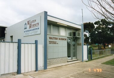
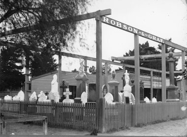
Photograph, Robson & Gray's Monumental Works in Lower Main Street Stawell 1999
Robson & Gray Monumental Works 1999 Lower Main Street Stawellstawell industry -
 Stawell Historical Society Inc
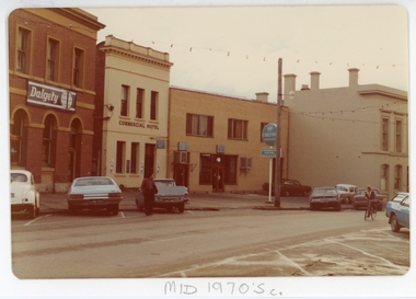
Photograph, Commercial Hotel in Upper Main Street Stawell c1970's
Commercial Hotel mid 1970's. Upper Main Street Stawell. stawell businesses -
 Stawell Historical Society Inc
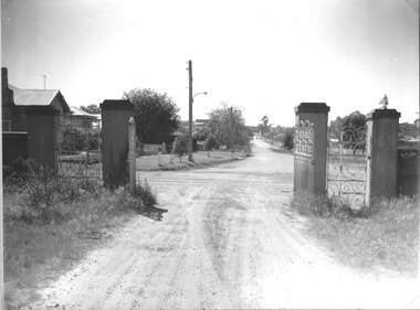
Photograph, Stawell Cemetery looking from inside through the gates up Barnes Street
Looking from inside the cemetery through the gates up Barnes Street.stawell -
 Stawell Historical Society Inc
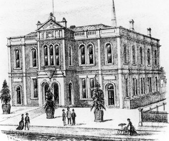
Drawing, Town Hall in the Main Street Stawell from the P.C. News Supplement 1888 -- Sketch
Town Hall Main Street. From P.C. News Supplement 1888stawell businesses -
 Stawell Historical Society Inc
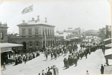
Photograph, Street Procession celebrating the end of WW1 in front of Post Office 1918
Street Procession celebrating the end of WW1 in front of Post Office 1918stawell ww1 -
 Stawell Historical Society Inc
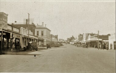
Photograph, Main Street Stawell looking East from near Town Hall
B/W Photo of Main Street looking East. C1930'sSmall Original on Back of Large Print 1920's cars visiblestawell streetscape -
 Stawell Historical Society Inc
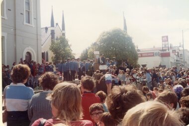
Photograph, Stawell Proclaimed a City celebrating with a Street Procession 1989 -- 10 Photos
Stawell Becomes a City 1989. Series street procession 10 photos.stawell -
 Stawell Historical Society Inc
Photograph, Robson & Grays Monumental Works in Lower Main Street Stawell 1923
Robson & Gray Monumental Works 1923 Lower Main Street Stawellstawell industry -
 Stawell Historical Society Inc
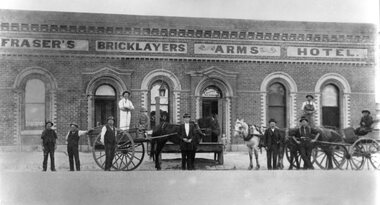
Photograph, Frasers Bricklayers Arms Hotel in Barnes Street Stawell
Frasers Bricklayers Arms Hotel Barnes Street with men in carts in frontstawell -
 Stawell Historical Society Inc
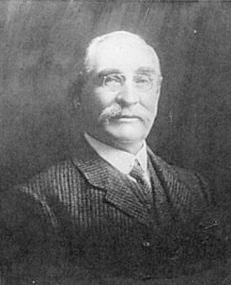
Photograph, Hon Thomas Skene 1888 -- Skene Street was named after him
Skene. Thomas (Hon) 1888. Skene Street Named after him.stawell -
 Greensborough Historical Society
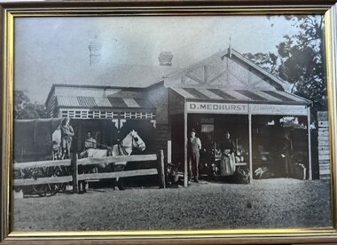
Photograph - Photograph (Framed), Mr & Mrs Medhurst and their children standing outside their fruit shop in Grimshaw Street Greensborough, 1910c
Medhurst Family standing outside their fruit shop in Grimshaw Street GreensboroughFrom the John Mackey collection. this item was displayed at the offices of Ryan, Mackey and Kelly, solicitors, Main Street Greensborough.Timber-framed photograph of Medhurst's Fruit Shop, black and white.greensborough, john mackey, medhurst family, david medhurst, jack medhurst, martha medhurst, medhurst's fruit shop -
 Stawell Historical Society Inc
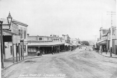
Photograph, Main Street Stawell looking West 1906
Main Street Looking West. Wooden Bull and Mouth Hotel 1906stawell -
 Beaufort Historical Society
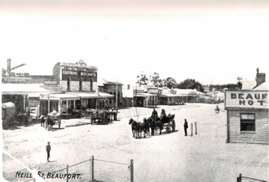
Photograph - Beaufort Street Scape, Neil Street Beaufort late 1800's
Neil Street Beaufort looking east from opposite Beaufort Hotel.Black and White photographbeaufort, historic beaufort streetscape -
 Stawell Historical Society Inc
Photograph, Stawell Police Station & New Court House in Patrick Street c2000
Stawell Police Station c2000 and new Court House Patrick Streetstawell -
 Eltham District Historical Society Inc
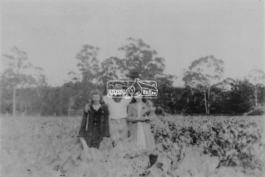
Photograph, From left: Unknown, Mario Fabbro and possibly Helen Skipper, Bell Street, Eltham
At Bell Street, Fabbro Farm, Eltham; From left: Unknown, Mario Fabbro and possibly Helen Skipper, standing in the middle of a vegetable crop. The site of the Fabbro farm (Diamond Creek side land) is now called Barrack Bushlands. It is doubtful that Fabbro's farm holding was ever called Barrak Park, This title is fairly recent after the Shire of Eltham purchased the land, including the last section in 1993/94. About this time the area on the west side of Falkiner Street was purchased by a private developer and developed as housing. The area in Bell Street opposite the Eltham High School was purchased by the State Government is recent years and is called Fabbro Fields. The Fabbro Family operated their farm in Bell Street, Eltham. 1 black and white photographfabbro's farm, bell street, eltham, maurice fabbro, farming, helen skipper, vegetables -
 Eltham District Historical Society Inc
Photograph, Fabbro's farm, Bell Street, Eltham, c.1990s
Fabbro's farm and house, Bell Street, Eltham, c.1990s. A crop of artichokes were planted on the farm at this time. The site of the Fabbro farm (Diamond Creek side land) is now called Barrack Bushlands. It is doubtful that Fabbro's farm holding was ever called Barrak Park, This title is fairly recent after the Shire of Eltham purchased the land, including the last section in 1993/94. About this time the area on the west side of Falkiner Street was purchased by a private developer and developed as housing. The area in Bell Street opposite the Eltham High School was purchased by the State Government is recent years and is called Fabbro Fields. The Fabbro Family operated their farm in Bell Street, Eltham. 1 colour photograph printed with white borderfabbro's farm, bell street, eltham, artichokes, barak farm -
 Eltham District Historical Society Inc
Photograph, Artichokes growing at Bell Street, Eltham, c.1990s
Fabbro's farm and house, Bell Street, Eltham, c.1990s. A crop of artichokes were planted on the farm at this time. The site of the Fabbro farm (Diamond Creek side land) is now called Barrack Bushlands. It is doubtful that Fabbro's farm holding was ever called Barrak Park, This title is fairly recent after the Shire of Eltham purchased the land, including the last section in 1993/94. About this time the area on the west side of Falkiner Street was purchased by a private developer and developed as housing. The area in Bell Street opposite the Eltham High School was purchased by the State Government is recent years and is called Fabbro Fields. The Fabbro Family operated their farm in Bell Street, Eltham. 1 colour photograph printed with white borderfabbro's farm, bell street, eltham, artichokes, barak farm -
 Eltham District Historical Society Inc
Photograph, Maurice Fabbro with artichokes growing at Bell Street, Eltham, c.1990s. Maurie is in his 70s
Fabbro's farm and house, Bell Street, Eltham, c.1990s. A crop of artichokes were planted on the farm at this time. The site of the Fabbro farm (Diamond Creek side land) is now called Barrack Bushlands. It is doubtful that Fabbro's farm holding was ever called Barrak Park, This title is fairly recent after the Shire of Eltham purchased the land, including the last section in 1993/94. About this time the area on the west side of Falkiner Street was purchased by a private developer and developed as housing. The area in Bell Street opposite the Eltham High School was purchased by the State Government is recent years and is called Fabbro Fields. The Fabbro Family operated their farm in Bell Street, Eltham. 1 colour photograph printed with white borderfabbro's farm, bell street, eltham, artichokes, barak farm, maurice fabbro -
 Ballarat Heritage Services
Photograph - digital copy, Jack and Kathllen Gervasoni Mayor and Mayoress of Kew 1979-80 at Chellowdene, 1979
Chellowdene was an architect designed triple fronted 1950s brick dwelling with an Edna Walling garden at 37 Wills Street, Kew. It was demolished by the subsequent owner.Copy of a colour photograph showing City of Kew Mayor John H. Gervasoni and Mayoress Kathleen Gervasoni in the front of their Kew property 'Chellowdene', 37 Wills Street, Kew. mayor, mayoral, portrait, kew, gervasoni, john, jack, k, mayoress, chellowdene, wills, kew mayors, wills street kew -
 Eltham District Historical Society Inc
Photograph, Mrs. Head, Grove Street
Mrs Emily Head, nee Whitehead (1874 - 1945) who lived in Grove Street, Eltham. She was the widow of fruit grower Richard Head. She owned land on the Bellevue Estate, land in and around north of Grove Street Eltham. The land was sub-divided in the 1960s. This photo forms part of a collection of photographs gathered by the Shire of Eltham for their centenary project book,"Pioneers and Painters: 100 years of the Shire of Eltham" by Alan Marshall (1971). The collection of over 500 images is held in partnership between Eltham District Historical Society and Yarra Plenty Regional Library (Eltham Library) and is now formally known as the 'The Shire of Eltham Pioneers Photograph Collection.' It is significant in being the first community sourced collection representing the places and people of the Shire's first one hundred years.Digital imagesepp, shire of eltham pioneers photograph collection, eltham, grove street, emily head, bellevue -
 The Beechworth Burke Museum Research Collection
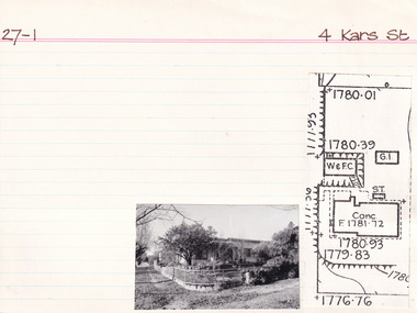
Card (Series) - Index Card, George Tibbits, 4 Kars Street, Beechworth, 1976
George Tibbits, University of Melbourne. Faculty of Architecture, Building and Town & Regional PlanningIndex system that support the research for Beechworth : historical reconstruction / [by] George Tibbits ... [et al]Arranged by street names of BeechworthEach index card includes: street name and number of property, image of property, allotment and section number, property owners and dates of ownership, description of the property according to rate records, property floor plan with dimensions.beechworth, george tibbitsbeechworth, george tibbits -
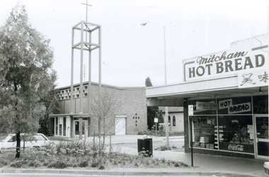 Whitehorse Historical Society Inc.
Photograph, Corner Edward Street & Whitehorse Road, Mitcham, 2000
Produced as one of a series of 24 prints commissioned by Nunawading & District Historical Society -|Theme: Intersections of Mitcham and Nunawading 2000/2001.|See also Series by P. Simmenauer on the same theme.Black and white photograph - print and negative of Corner of Edward Street & Whitehorse Road looking North West, from L-R: Anglican Church of Christ; Church Hall in weatherboard. In streetscape (Whitehorse Road) Mitcham Hot Bread Kitchen, Coca Cola Sign and Chinese calligraphy on shop sign.christ church anglican church, mitcham, mitcham hot bread shop, edward street