Showing 23749 items
matching sardine-creek
-
 Orbost & District Historical Society
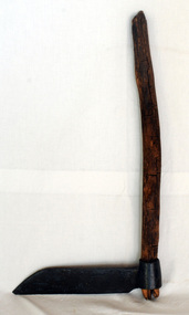
Paling knife, shingle froe, c. 1870s - 1930s
Likely used by the Jensen family who were early settlers in the Martin's Creek area, 35 miles north of Orbost, along the Bonang - Orbost Road in c. 1890. Peter Jensen came from Denmark. A flat iron blade, sharpened on the bottom and attached to a wooden handle. The blade has a pointed end.BRADES CO.shingle-making roofing-shingles house-construction -
 Hume City Civic Collection
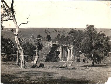
Photograph
The photo is part of the Eric Boardman Collection which is held in the George Evans Museum. There are two bridges constructed in the Rupertswood Estate. The bridge in this photograph has been built across Jackson's Creek beyond Rupertswood Mansion.A black and white photograph of one of the two railway bridges within the Rupertswood Estate. There are gnarled gum trees in the foreground and hilltops across the skyline. In the middle distance there is a view of the railway embankment.rupertswood, railway bridges, rupertswood estate, estates, bridges, boardman, eric, sunbury news, newspapers, george evans collection -
 Nillumbik Historical Society Incorporated
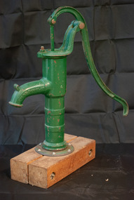
Functional object - Hand Pump, W & B Douglas Pump Factory, Hand Pump to Manually Draw Water from Well, Mid - Late 19th Century
Hand Pump. Reticulated water did not reach Diamond Creek until 1914. This beautiflly restored hand pump raised water from the outside domed well to provide cool clear water for domestic use.The Hand Pump is a well preserved example of equipment used domestically in the Diamond Creek areaHand pump used for pumping water from shallow wells. Restored by Kim Howard in 1996. Green. Column is screwed to base which is mounted on Redgum planks.PATENTED 1842, W & B DOUGLAS, "MIDD'A CONN.#handpump, #waterpump, #domesticuse -
 Torquay and District Historical Society
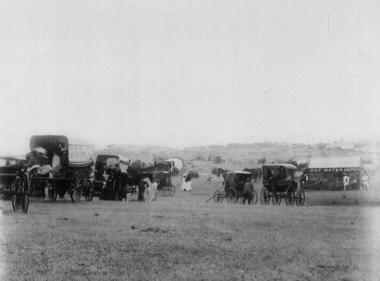
Copy Photo, Torquay History Exhibition 2016, Produced for the exhibition
Photo taken on new years day 1900 shows Edward Molyneux's Hot Water Depot, established on the bank of Spring Creek,Torquay to cater for the growing number of visitors to the area. Note the conveyances of the day in the foreground.The Hot Water Depot was an innovative response to the demands of an embryonic tourist industry in Torquay.Black and white photo -
 Hume City Civic Collection
Photograph, Mill Falls
The photograph is of the Jacksons Creek taken in the vicinity of Mill Falls, near the former 'Springvale' winery, which was downstream from the Sunbury township. In 1971 the Shire of Bulla purchased 'Springvale' site and established the town's sewerage plant.The former 'Springvale' winery was one of a number of wineries that were established in Sunbury in the 19th century.A scanned coloured photograph with rounded corners of a valley with a meandering stream with a small dammed section in the foreground. There is a line of trees across the distant hilltops. mill falls, springvale winery, jacksons creek -
 Sunbury Family History and Heritage Society Inc.
Photograph, SUNBURY BATHS
The scene featured on the post card is a view of The Nook on the Jacksons Creek. For many years before the Aquatic Centre was build in the town, The Nook was the swimming place for local residents. The surrounding area had seats and change rooms. The Sunbury Swimming club was established at this site before the Aquatic Centre was built.A sepia photograph in post card format of river bend and small sandy beach on the bank.the nook, swimming -
 Tarnagulla History Archive
Letter, 13th March, 1862
A large lot of papers, including this and other telegrams, were apparently found in the ceiling cavity of the Sandy Creek/Tarnagulla Post and Telegraph Office in the later 20th Century, during building works. Donald Clark Collection. Handwritten letter (or draft text for a telegram) sent from Tarnagulla, from C. Rigg (?) to James McKean Esq, Carisbrook. Message reads 'Send two loads of flour to ________ with some ham (?)' -
Tarnagulla History Archive
Letter, 4th March, 1862
A large lot of papers, including this and other telegrams, were apparently found in the ceiling cavity of the Sandy Creek/Tarnagulla Post and Telegraph Office in the later 20th Century, during building works. Donald Clark Collection. Handwritten letter (or draft text for a telegram) sent from Tarnagulla, from Joseph Foos to Mr Sam Woollan, Theatre Royal, Inglewood. Message reads 'Yes'. -
Tarnagulla History Archive
Letter, 15th March, 1862
A large lot of papers, including this and other telegrams, were apparently found in the ceiling cavity of the Sandy Creek/Tarnagulla Post and Telegraph Office in the later 20th Century, during building works. Donald Clark Collection. Handwritten letter (or draft text for a telegram) sent from Tarnagulla, from D.T.O. Connor (?) to G.F. Nagle Esq, Inglewood. Message reads 'See Doody say timber is Seven and nine _____ measurement if that will suit can load (word 'today' crossed out)'. -
Tarnagulla History Archive
Telegram, 20th March, 1862
A large lot of papers, including this and other telegrams, were apparently found in the ceiling cavity of the Sandy Creek/Tarnagulla Post and Telegraph Office in the later 20th Century, during building works. Donald Clark Collection. Telegram sent from Tarnagulla, from Patrick Fahey, Seniro Constable to Sergt Acton, Inglewood. Message reads 'Re criminal offence of this date. Man named Jas. Murphy arrested here answers this description except in hight (incorrect spelling). Six small common brooches found in his possession & _____ ______ _______ packet inside ('left breas' crossed out) right breast, and one outside left breast. ________ required. Reply.' -
Tarnagulla History Archive
Note, circa 1862
A large lot of papers, including this and other telegrams, were apparently found in the ceiling cavity of the Sandy Creek/Tarnagulla Post and Telegraph Office in the later 20th Century, during building works. Donald Clark Collection. Handwritten note addressed to W. Davies, Albion Hotel, Melbourne from E. Arnott. Text reads '_____ is _____ as I told you awaiting your return'. -
Tarnagulla History Archive
Draft for telegram, 3rd March 1862
A large lot of papers, including this and other telegrams, were apparently found in the ceiling cavity of the Sandy Creek/Tarnagulla Post and Telegraph Office in the later 20th Century, during building works. Donald Clark Collection. Handwritten draft of text for a telegram sent from Tarnagulla Telegraph Office. From J. Beynon to Mr. William L. Jones, Creswick. Text reads 'Sending him all in at that price, we are all well' -
Tarnagulla History Archive
Telegram, 11th March 1862
A large lot of papers, including this and other telegrams, were apparently found in the ceiling cavity of the Sandy Creek/Tarnagulla Post and Telegraph Office in the later 20th Century, during building works. Donald Clark Collection. Telegram sent from Tarnagulla Telegraph Office. From William Harper to Mr Dunbar, Dunolly. Text reads 'Shall I subpoena witnesses in case Owen declines postponement. Will Phelps be here to apply'. -
Tarnagulla History Archive
Draft for Telegram, 11th March 1862
A large lot of papers, including this and other telegrams, were apparently found in the ceiling cavity of the Sandy Creek/Tarnagulla Post and Telegraph Office in the later 20th Century, during building works. Donald Clark Collection. Handwritten draft for the telegram catalogued as THA-2019.0781. Note authored by William Harper to Mr Dunbar, Dunolly Solicitor. -
 Ballarat Tramway Museum
Newspaper - The Courier report, "All Aboard", 9/4/2024
Report by Alex Ford with photos by Lachlan Bence of the operation of Horse tram No. 1 on Sunday 7/4/2024. Clydesdales from Sandy Creek Clydesdales Noah and Brooke hauled the tram. Quotes Paul Mong.Yields information about the BTM's activities in running the horse tram.Newspaper pages 1 and 5 - full colour photos on newsprint.horse trams, btm, clydesdales, tramcars, operations -
Tarnagulla History Archive
Set of Maps (Mining & Local Area), various
David Gordon Collection. A set of mining documents, maps and plans: 1. Dunolly Deep Leads - showing location and names of deep lead gold deposits in region around Dunolly including at Tarnagulla and Newbridge. Geological Survey of Victoria, Department of Minerals and Energy. Bulletin No. 62, Map No. 4 Dunolly (770 x 485 mm). 2. Poseidon Lead (Facsimile) 3. Nick O Time Lead (Facsimile) 4. Happy Go Lucky Mine prospectus and plan (colour copy) 5. Jones Creek GM Co. (Raven & Gourlay's) Waanyarra - Prospectus (colour copy) 6. Poseidon Area Plan (colour copy) and Poseidon Area map (B&W copy). 7. Cross-section diagram of Spread Eagle Reef 8. New Birthday Gold Mine - area map (colour copy) and mine cross-section ( (colour copy). 9. Cross section of Poverty Reef, by Department of Mines (B&W copy, 2 parts on A2 paper) 10. Time-Lease Graph for Watts Reef, Specimen Reef, Stony Reef, Poverty Reef (second page in detail), created by Eric WIlkinson for Ref Mining NL, 1995 11. 1859 Plan of the Gold Workings & Township of Sandy Creek, Shewing the Mining Leases, Extended Claims & Machinery by R.J. McMillan, Mining Surveyor (B&W copy) 12. Longitundinal and Transverse Vertical Sections of Poverty Reef, Sandy Creek 1859, by R.J. McMillan, Mining Surveyor (B&W copy) 13. Tarnagulla Locality Plan (B&W copy) 14. Universal Grid Reference Map (Topographic) for Laanecoorie North (2 copies) 15. Universal Grid Reference Map (Topographic) for Inglewood South 16. Poverty Reef, Plan showing shafts and early tenements, created by Eric WIlkinson for Ref Mining NL, 1995 17. Locality Map of mining leases in Tarnagulla 18. Plan and Elevation of part of Poverty Reef, Sandy Creek, showing the claims and positions of the shaft. by R.J. McMillan, Mining Surveyor (Facsimile, composed of taped together components) 19.Plan and Elevation of part of Poverty Reef, Sandy Creek, showing the claims and positions of the shaft. by R.J. McMillan, Mining Surveyor (Facsimile, composed of taped together components) -
 Lara Heritage and Historical inc.
Compact
This compact was owned by Rose Alice Normington, nee Lupton. She was born in Roto, NSW in 1880 and moved to Victoria with her parents and siblings when she was five years old. They settled in Barker's Creek via Castlemaine. In 1899 Rose married Maurice Normington Jnr who also lived in Barker's Creek. They had six daughters and one son. Rose Normington died in 1966. Information provided by Pam Strijder 2017 - granddaughter of Rose Normington. I think this compact would originate from early in the twentieth century, based on the fact that it contains a zipper.This compact is an example of a high-quality compact which it is thought would be widely owned by ladies early in the twentieth century.Round, black leather lady's powder compact with embroidered top. Zipper on side. Nilcompact -
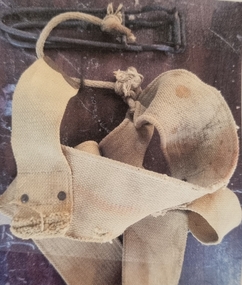 Falls Creek Historical Society
Equipment - Belt and Nutcracker, 1951
The first nutcracker tow at Falls Creek was the Nissen Tow operated by Toni and Skippy St. Elmo. It had a capacity of five people at one time and cost 6/- day in 1951. The tow was powered by a Buick engine and operated from 1951 until 1960. Other nutcracker tows at Falls Creek were the Village (left side), Village (right side) and the Dog Patch Tow, By the 1960s nutcracker tows were rapidly being replaced in the developing major resorts although a few rope tows remained in use largely to assist access over areas of fairly flat terrain.This item is significant because it came from the original Rope Tow, Nissen, at Falls Creek, VictoriaThe nutcracker (metal clamp) has two handles that clamp onto the rope when closed together. The clamping part of the nutcracker is at the end near the hinge. The nutcracker is attached to a belt via a short rope, and a small metal loop is attached to the belt, onto which the nutcracker can be stored whilst skiing. When riding the nutcracker, the rope attachment is worn to the front which can then be pushed around to the side whilst skiing. The belt needs to be worn tightly around the hips.falls creek tows, nissen tow, toni and skippy st. elmo -
 Eltham District Historical Society Inc
Photograph, Liz Pidgeon, Heritage Excursion; Maroondah Aqueduct, 3 September 2016, 3 September 2016
Property related to Yarra Valley Water, Diamond Creek Newsletter No., 229, August 2016 Heritage Excursion - Maroondah Aqueduct Walk - Saturday 3rd September The Maroondah Aqueduct was once a major link in Melbourne’s water supply system. It was built between 1886 and 1891 to transfer water from the Watts River near Healesville to the Preston Reservoir. It was 66 km in length, made up of 41 km of open channel, 10 km of tunnel through hills and 15 km of pipeline across stream valleys known as inverted siphons. The section of the aqueduct through the Eltham area has been abandoned since the 1980s but the open channel has largely been retained. A recreational path follows the aqueduct reserve. For our excursion on 3rd September we intend to walk along the section of the aqueduct adjacent to Allendale Road. This is a section not visited on previous excursions and includes the transition from open channel to the inverted siphon across the Diamond Creek valley. Apart from the aqueduct itself the main feature of the walk is the extensive views across Eltham North and Diamond Creek. Along the way we will talk about the history of the aqueduct and the area. This easy walk is about 3 km return and will take 2 to 2.5 hours. It will start at 2pm at the junction of Allendale Road with Godber Road and Zig Zag Road North, officially Diamond Creek, but on the northern boundary of Eltham. (Melway ref.12 B10). Born Digitalmaroondah aqueduct, eltham north, activities, eltham district historical society, heritage excursion, yarra valley water, diamond creek -
 Eltham District Historical Society Inc
Photograph, Liz Pidgeon, Heritage Excursion; Maroondah Aqueduct, 3 September 2016, 3 September 2016
Sign for Yarra Valley Water at Diamond Creek property Newsletter No., 229, August 2016 Heritage Excursion - Maroondah Aqueduct Walk - Saturday 3rd September The Maroondah Aqueduct was once a major link in Melbourne’s water supply system. It was built between 1886 and 1891 to transfer water from the Watts River near Healesville to the Preston Reservoir. It was 66 km in length, made up of 41 km of open channel, 10 km of tunnel through hills and 15 km of pipeline across stream valleys known as inverted siphons. The section of the aqueduct through the Eltham area has been abandoned since the 1980s but the open channel has largely been retained. A recreational path follows the aqueduct reserve. For our excursion on 3rd September we intend to walk along the section of the aqueduct adjacent to Allendale Road. This is a section not visited on previous excursions and includes the transition from open channel to the inverted siphon across the Diamond Creek valley. Apart from the aqueduct itself the main feature of the walk is the extensive views across Eltham North and Diamond Creek. Along the way we will talk about the history of the aqueduct and the area. This easy walk is about 3 km return and will take 2 to 2.5 hours. It will start at 2pm at the junction of Allendale Road with Godber Road and Zig Zag Road North, officially Diamond Creek, but on the northern boundary of Eltham. (Melway ref.12 B10). Born Digitalmaroondah aqueduct, eltham north, activities, eltham district historical society, heritage excursion, diamond creek, yarra valley water, sign -
 Eltham District Historical Society Inc
Photograph, Liz Pidgeon, Heritage Excursion; Maroondah Aqueduct, 3 September 2016, 3 September 2016
View of Diamond Creek Newsletter No., 229, August 2016 Heritage Excursion - Maroondah Aqueduct Walk - Saturday 3rd September The Maroondah Aqueduct was once a major link in Melbourne’s water supply system. It was built between 1886 and 1891 to transfer water from the Watts River near Healesville to the Preston Reservoir. It was 66 km in length, made up of 41 km of open channel, 10 km of tunnel through hills and 15 km of pipeline across stream valleys known as inverted siphons. The section of the aqueduct through the Eltham area has been abandoned since the 1980s but the open channel has largely been retained. A recreational path follows the aqueduct reserve. For our excursion on 3rd September we intend to walk along the section of the aqueduct adjacent to Allendale Road. This is a section not visited on previous excursions and includes the transition from open channel to the inverted siphon across the Diamond Creek valley. Apart from the aqueduct itself the main feature of the walk is the extensive views across Eltham North and Diamond Creek. Along the way we will talk about the history of the aqueduct and the area. This easy walk is about 3 km return and will take 2 to 2.5 hours. It will start at 2pm at the junction of Allendale Road with Godber Road and Zig Zag Road North, officially Diamond Creek, but on the northern boundary of Eltham. (Melway ref.12 B10). Born Digitalmaroondah aqueduct, eltham north, activities, eltham district historical society, heritage excursion, diamond creek, acqueduct trail -
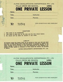 Falls Creek Historical Society
Lifts and Ski School Lesson tickets 1981
SKI TICKETS Before tows and lifts were introduced at Falls Creek, it could take skiers 20 minutes to climb to the Summit … but only TWO minutes to go back to the bottom. The arrival of tows, then chairlifts and T-bars changed the face of skiing forever. The first rope tow was constructed by Toni St. Elmo for the 1951 winter season. Bob Hymans installed a smaller tow for his guests at Skyline Lodge. Tows were still quite slow, so in 1956 Bob Hymans created his single chairlift. In 1958 the Village rope tow, designed by Albury engineer Jock Wilson, opened. It was financed by shareholders including Bill Griffith (Bowna Ski Club) and the Bridgford family (St. Trinian’s Ski Club). Several other tows followed including the Summit T-bar in 1961, built by Ron McCallum and operated by Alpine Developments Pty. Ltd. which was a company formed by C. H. (Bill) Bridgford. By 1982 Falls Creek was served by 16 different lifts or T-bars, all owned and operated by Alpine Developments (Holdings) Pty. Ltd. During the development of Falls Creek, different methods have been used to pay for the use of tows, lifts and T-bars … including metal tokens, single tickets, strips of tickets and season passes. The Falls Creek Historical Society Collection includes many examples of these items.These tickets are significant because they represent a stage in the management at Falls Creek Tourist Village.A set of tickets available for the Winter season of 1981ski tickets falls creek, falls creek tourism, falls creek management -
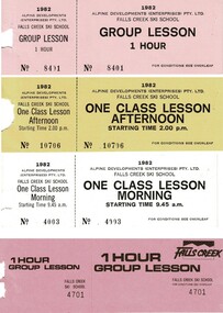 Falls Creek Historical Society
Lifts and Ski School Lesson tickets 1982
SKI TICKETS Before tows and lifts were introduced at Falls Creek, it could take skiers 20 minutes to climb to the Summit … but only TWO minutes to go back to the bottom. The arrival of tows, then chairlifts and T-bars changed the face of skiing forever. The first rope tow was constructed by Toni St. Elmo for the 1951 winter season. Bob Hymans installed a smaller tow for his guests at Skyline Lodge. Tows were still quite slow, so in 1956 Bob Hymans created his single chairlift. In 1958 the Village rope tow, designed by Albury engineer Jock Wilson, opened. It was financed by shareholders including Bill Griffith (Bowna Ski Club) and the Bridgford family (St. Trinian’s Ski Club). Several other tows followed including the Summit T-bar in 1961, built by Ron McCallum and operated by Alpine Developments Pty. Ltd. which was a company formed by C. H. (Bill) Bridgford. By 1982 Falls Creek was served by 16 different lifts or T-bars, all owned and operated by Alpine Developments (Holdings) Pty. Ltd. During the development of Falls Creek, different methods have been used to pay for the use of tows, lifts and T-bars … including metal tokens, single tickets, strips of tickets and season passes. The Falls Creek Historical Society Collection includes many examples of these items.These tickets are significant because they represent a stage in the management at Falls Creek Tourist Village.A set of tickets showing the array of passes available for the 1982 season.falls creek passes, falls creek ski school, falls creek management -
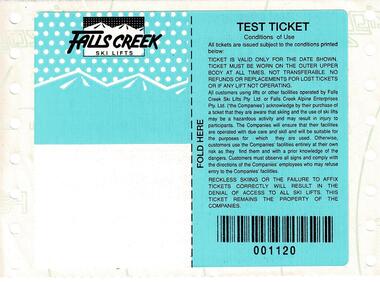 Falls Creek Historical Society
Ski Lift Test Ticket 1995
SKI TICKETS Before tows and lifts were introduced at Falls Creek, it could take skiers 20 minutes to climb to the Summit … but only TWO minutes to go back to the bottom. The arrival of tows, then chairlifts and T-bars changed the face of skiing forever. The first rope tow was constructed by Toni St. Elmo for the 1951 winter season. Bob Hymans installed a smaller tow for his guests at Skyline Lodge. Tows were still quite slow, so in 1956 Bob Hymans created his single chairlift. In 1958 the Village rope tow, designed by Albury engineer Jock Wilson, opened. It was financed by shareholders including Bill Griffith (Bowna Ski Club) and the Bridgford family (St. Trinian’s Ski Club). Several other tows followed including the Summit T-bar in 1961, built by Ron McCallum and operated by Alpine Developments Pty. Ltd. which was a company formed by C. H. (Bill) Bridgford. By 1982 Falls Creek was served by 16 different lifts or T-bars, all owned and operated by Alpine Developments (Holdings) Pty. Ltd. During the development of Falls Creek, different methods have been used to pay for the use of tows, lifts and T-bars … including metal tokens, single tickets, strips of tickets and season passes. The Falls Creek Historical Society Collection includes many examples of these items.This ticket is significant because they represent a stage in the progression of chair lifts and management at Falls Creek Tourist Village.A test ticket produced prior to the full run of tickets being created for the 1995 season.falls creek passes, falls creek ski lifts, falls creek tourism -
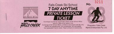 Falls Creek Historical Society
Lift and Ski School Lesson tickets 1988, Alpine Development Holdings Pty Ltd
SKI TICKETS Before tows and lifts were introduced at Falls Creek, it could take skiers 20 minutes to climb to the Summit … but only TWO minutes to go back to the bottom. The arrival of tows, then chairlifts and T-bars changed the face of skiing forever. The first rope tow was constructed by Toni St. Elmo for the 1951 winter season. Bob Hymans installed a smaller tow for his guests at Skyline Lodge. Tows were still quite slow, so in 1956 Bob Hymans created his single chairlift. In 1958 the Village rope tow, designed by Albury engineer Jock Wilson, opened. It was financed by shareholders including Bill Griffith (Bowna Ski Club) and the Bridgford family (St. Trinian’s Ski Club). Several other tows followed including the Summit T-bar in 1961, built by Ron McCallum and operated by Alpine Developments Pty. Ltd. which was a company formed by C. H. (Bill) Bridgford. By 1982 Falls Creek was served by 16 different lifts or T-bars, all owned and operated by Alpine Developments (Holdings) Pty. Ltd. During the development of Falls Creek, different methods have been used to pay for the use of tows, lifts and T-bars … including metal tokens, single tickets, strips of tickets and season passes. The Falls Creek Historical Society Collection includes many examples of these items.A set of three 7 Day Anytime tickets for the 1988 Season. This set includes one ticket for a private lesson, one for a class lesson and the final ticket is for a child. These tickets could redeemed at any time during the 1988 winter season.7 day anytime tickets, falls creek passes, falls creek winter season -
Clunes Museum
Postcard - POSTCARD FROM THE ROCKS, HORNBY STUDIO
ONE SEPIA POSTCARD TITLED "CLUNES FROM ROCKS" IN WHITE HAND WRITING ON IMAGE. SIGNIFICANT BUILDINGS SHOWN ARE THE POST OFFICE , BANKS, SOME MATURE TREES AND MT BECKWORTH IN THE BACKGROUNDON BACK: DEAR ALLIE, AS I PROMISED YOU A VIEW OF CLUNES I AM SENDING YOU THIS ONE. HE IS SOLD OUT OF THE ONES WITH THE CREEK. i HOPE YOU ARE WELL. i REMAIN YOUR AFFECT COUSIN RANDAL STAMPED IWTH "POSTCARD" - CORRESPONDENCE AND KODAK AUSTRALIAclunes from the rocks, postcard -
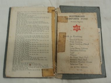 National Wool Museum
WWI and WWII Knitting books, Australian red Cross, Australian Red Cross Society Knitting Book and Australian Comforts Fund Guide to Knitting, Early 20th Century
Knitting Books provided by The Red Cross for women to contribute to the war effort by knitting garments for soldiers to stay warm. Second booklet also contains a list of donations accepted such as tinned food.Green Folder containing three knitting books. Knitting pattern for wounded soldiers or soldiers currently serving eg air pilots neck muff, airmens wollen gloves and bed socks. Newspaper clipping about knitting.On outside green folder " L.A Anderson, Sutherland's Creek." First Booklet. " Australian Red Cross Society Knitting Book" Second Booklet. " Australian Comforts Fund Victorian Division Guide to Knitting" Index of knitting patterns. Third Booklet. "Red Cross Society Australian Branch"wwi, wwii, australian red cross, red cross society, australian comforts fund, knitting, knitting patterns, victoria -
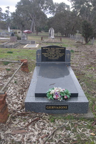 Ballarat Heritage Services
Photograph - Photograph - Colour, Sandon Cemetery, 2017, 16/07/2017
Mick Gervasoni was the son of George August Gervasoni and Anne Pedretti, and the grandson of Luigi Gervasoni and Augusta Ritzau.Grave of Michael Gervasoni.Michael Paul Gervasoni Born Yandoit Creek Died 26-11-2005 Aged 100 Loved Husband of Patricia Patricia Jessie (Nee Phillips) Born Melbourne Hill Lancefield Died 1-8-2009 aged 92 Adored father & mother of Veronica and Fayesandon, sandon cemetery, michael gervasoni, mick gervasoni, pat gervasoni, patricia gervasoni, yandoit creek, melbourne hill lancefield -
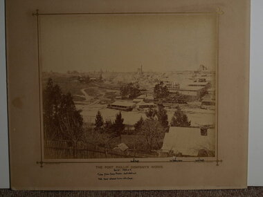 Clunes Museum
Photograph, BEAUCHAMP, PHOTO. 104 STURT STREET, BALLARAT, CIRCA 1884 - 1885
SEPIA PHOTOGRAPH OF PORT PHILLIP COMPANY'S WORKS.THE PORT PHILIP COMPANY'S WORK'S. HANDWRITTEN NOTES: PERIOD 1884 OR 5. TAKEN FROM CAMP PARADE: NOERTH WEST END NOTE SAND ALLOWED TO RUN INTO CREEK NORTH SHAFT, 2ND BATTERY HOUSE, SOUTH SHAFT. BEAUCHAMP PHOTO, 104 STURT STREET, BALLARATlocal history, mining, port phillip mine -
Bendigo Historical Society Inc.
Map - PLAN GENERAL SURVEY MALMSBURY PORCUPINE INN, FOREST CREEK TO GOLDEN POINT. ALEXANDRA RANGE 1853
Colour Copy of Plan of the General Survey from the Town of Malmsbury to the Porcupine Inn, from the sources of Forest Creek to Golden Point, shewing (sic) the Alexandrian Range also Sawpit Gully Bendigo and Bullock Creeks. Handwritten note under the title a follows '' Forwarded to the Colonial Secretary with my letter No A 53/105 dated 30th March 1853 for transmission to the Geological Surveyor. R Hoddle Surveyor General. ' Stamped by Department of Mines Victoria with record#123 in Top right Hand corner. Also contains a catalogue number 2053/M/2. Part of the Contents of a DVD entitled 'Mapping Great Change' - Archival Maps, produced to support an exhibition in the Post Office Gallery Bendigo. A description of the Map, its history and implications for both historical and future discussions is contained in an Essay 'Mapping Great Changes' : The landscape of central Victoria by Gerry Gill.R. Hoddlemap, bendigo, country lands