Showing 27536 items
matching yarra-river
-
 Port Melbourne Historical & Preservation Society
Plan, J W Banks, Plans and Sections of Tramsway, Apr 1889
Large book of 9 pages, incl. title page, bound on left with black tape, wih plans and typeset descriptions of a proposal to run a cable tram under the Yarra from Williamstown to Melbourne (Falls Bridge) via Port Melbourne. Submitted to Victorian Legislative Assembly 1889Signed p. 2 by J.W. Banks, C.E.transport - tramways, town planning - proposals shelved, williamstown, j w banks -
 Melbourne Tram Museum
Photograph - Colour Photograph/s, Ron Scholten, 8/10/2006 12:00:00 AM
Colour photograph print of HTT No. 32 (Bendigo owned tram) at the Yarra Trams centenary celebrations of 100 years of electric trams in Melbourne, 8-10-2006, at the then Docklands terminal facility. Has other trams in the background. Printed on Kodak Royal Paper, photo by Ron Scholten.trams, tramways, htt, docklands, tram 32 -
 Melbourne Tram Museum
Poster, Equal Opportunity Commission of Victoria, "We're working for our future - just like you", c2008
Poster - A3 full colour printed on heavy paper, titled "We're working for our future - just like you" featuring a photograph of three young students on a tram of three different ethnicities. Sponsored by Connex, Yarra Trams and Equal Opportunity Commission of Victoria. Not dated - c2008.trams, tramways, posters, yarra trams, connex, employment, personnel -
 Melbourne Tram Museum
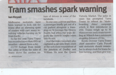
Newspaper, Herald Sun, "Tram smashes spark warning", 20/6/2024
Newspaper report by Ian Royall about Yarra Trams recording some 450 car incidents so far this year - about 3 per day. Notes CCTV on trams, the Dudley and William Sts roundabout and that Rhino on a skateboard campaign is being rebooted. Quotes Yarra Trams CEO Carla PurcellYields information about the number of incidents so far during 2024 with motor car to tram collisions.Newspaper cutting from the Herald Sun, 20/6/2024 page 11Has source label on rear.tramways, accidents, yarra trams, collisions -
 Eltham District Historical Society Inc
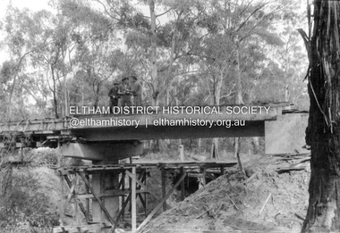
Album - Photograph, J.A. McDonald, Henley Road Bridge over Watsons Creek, Aug. 1962
Henley Road Bridge over Watsons Creek Yarra Glen Abutment August 1962Record of various Shire of Eltham infrastructure works undertaken during the period of 1952-1962 involving bridge and road reconstruction projects, sometimes with Eltham Shire Council Project Reference numbers quoted. It was during this period that a number of significant improvements were made to roads and new bridges constructed within the shire that remain in place as of present day (2022). In many situations, the photos provide a tangible visible record of infrastructure that existed throughout the early days of the Shire. The album was put together by or under the direction of the Shire Engineer, J.A. McDonald.H941 stamped on reverse (film processing #)infrastructure, shire of eltham, bridge construction, road construction, bushfires, 1962-08, bend of islands, henley road, henley road bridge, kangaroo ground, oxley bridge, watsons creek -
 Eltham District Historical Society Inc
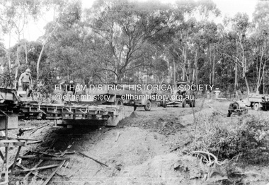
Album - Photograph, J.A. McDonald, Henley Road Bridge over Watsons Creek, Sep. 1962
Henley Road Bridge over Watsons Creek Yarra Glen Abutment September 1962Record of various Shire of Eltham infrastructure works undertaken during the period of 1952-1962 involving bridge and road reconstruction projects, sometimes with Eltham Shire Council Project Reference numbers quoted. It was during this period that a number of significant improvements were made to roads and new bridges constructed within the shire that remain in place as of present day (2022). In many situations, the photos provide a tangible visible record of infrastructure that existed throughout the early days of the Shire. The album was put together by or under the direction of the Shire Engineer, J.A. McDonald.H941 stamped on reverse (film processing #)infrastructure, shire of eltham, bridge construction, road construction, bushfires, bend of islands, henley road, henley road bridge, kangaroo ground, oxley bridge, watsons creek, 1962-09 -
 Greensborough Historical Society
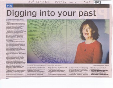
Article - Newspaper Clipping, Digging into your past, 28/07/2010
Article with Liz Pidgeon about researching Family History at Yarra Plenty Regional Library.Newspaper Clipping, text and colour imagefamily history, yarra plenty regional library, liz pidgeon -
Whitehorse Historical Society Inc.
Map, Melbourne and Metropolitan Board of Works, Feb 1982
Map area: North - Laburnum and Blackburn Stations East - Blackburn Lake South - bordering Canterbury Road West - Middleborough Roadnon-fictionMap area: North - Laburnum and Blackburn Stations East - Blackburn Lake South - bordering Canterbury Road West - Middleborough Roadmaps, melbourne and metropolitan board of works, parish of nunawading -
Robin Boyd Foundation
Letter, Blake & Riggall (Solicitors and Notaries), 21.03.1958
Letter to Robin Boyd regarding 290 Walsh St, South Yarra property valuation. -
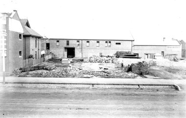 Ballarat Tramway Museum
Photograph - Geelong MESCO offices, Melbourne Electric Supply Co (MESCo), c.1900-10
Site cleared for construction of MESCO offices on SW corner of Yarra and Corio Sts., Geelong.Yields information on early Geelong streetscape and constructionBlack and white print on paper.Plate 2-8 Spare written in ink on the back of the photograph.mesco geelong, corner yarra and corio sts. geelong -
 Warrnambool and District Historical Society Inc.
Postcard - Views of Warrnambool
Pictures depicting scenes of Warrnambool & District. 9 pictures are, The Beach. Hopkins River. Thunder Point. Liebig St. Botanical Gardens. Breakwater and pier. Hopkins River. Soldiers Memorial. Hopkins Falls.A typical souvenir postcard from the 1930'sOblong postcard with flip down views of Warrnambool from a purse with two kittensValentine's Mail Novelty Post Card; Good Luck And a Bagful of Views from WARRNAMBOOLwarrnambool, hopkins river, warrnambool breakwater, warrnambool postcards, postcards, hopkins falls, thunder point, soldiers memorial -
Tatura Irrigation & Wartime Camps Museum
Book, The Supply of Water for Irrigation in Victoria 1881-1981, 1981
Includes history of early irrigation schemes, Goulburn system, river Murray system, Post war expansion, drainage and salinity. Change from State Rivers & Water Supply Commission to Rural CommissionCream cover, black writing. Cover photo of early days of irrigation, many channels constructed by teams of horses dragging scoops.sr & wscommision, books, rural, industry -
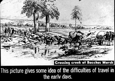 Bendigo Historical Society Inc.
Slide - DIGGERS & MINING. THE GOLD ERA, c1850s
Diggers & mining. The gold era. This picture gives some idea of the difficulties of travel in the early days. Shows 10 oxen pulling a large heavy cart through a river, a rider from the top of the cart falls off. Another cart is being pulled by a horse, one man has fallen on the ground another is headfirst of the large cart, 3 men behind the cart may be pushing. A dead horse lay by the river. Crossing a creek at Bacchus Marsh. Markings 40 994.031 GOL:5. Used as a teaching aid.hanimounteducation, tertiary, goldfields -
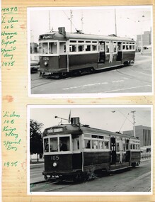 Melbourne Tram Museum
Album - Photo Album, Neil Mackintosh, Bob Lilburn, L class 106 at Hanna Street Depot, special day 1975, 1947
Two Pages from a photo album book with adhesive surface and clear plastic sheet cover on cardboard sheet - containing three photographs of Melbourne L class trams and of the Murray River Queen paddle boat. 1 - L class 106 at Hanna Street Depot, special day 1975 - Neil Mackintosh photo? 2 - No. 105 Kingsway 3 - No. 103, Glenhuntly Station, 11/1/1947 - Photo by Bob Lilburn 4 - Murray River Queen paddle boat. Not known who assembled the album.trams, tramways, l class, kingsway, south melbourne depot, hanna st depot, glenhuntly, tram 106, tram 105, tram 103 -
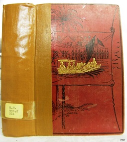 Flagstaff Hill Maritime Museum and Village
Book, Through The Dark Continent
WARRNAMBOOL MECHANICS’ INSTITUTE Warrnambool's Mechanics' Institute (or Institution as it was sometimes called) was one of the earliest in Victoria. On 17th October 1853 a meeting was held where it was resolved to request the Lieutenant Governor of the Colony to grant land for the erection of a Mechanics' Institutes building. A committee was formed at the meeting and Richard Osburne chaired the first meeting of this committee. The land on the North West corner of Banyan and Merri Streets was granted but there were no funds to erect the building. The Formal Rights of the Warrnambool Mechanics' Institute's encompassed its aims and these were officially adopted in1859; "This Institution has for its object the diffusion of literary, scientific, and other useful knowledge amongst its members, excluding all controversial subjects, religious or political. These objects are sought to be obtained by means of a circulating library, a reading room, the establishment of classes, debates, and the occasional delivery of lectures on natural and experimental philosophy, mechanics, astronomy, chemistry, natural history, literature, and the useful and ornamental arts, particularly those which have a more immediate reference to the colony." The Warrnambool Mechanics' Institute opened its first reading room in November1884 in the National School building at the corner of Banyan and Timor Streets. The Institute was funded by member subscription, payable on a quarterly, half yearly or yearly basis. Samuel Hannaford, the Manager of the Warrnambool Bank of Australasia, was the first Honorary Secretary of the Mechanics' Institutes, and an early President and Vice-President. He also gave several of the early lectures in the Reading Room. Another early Secretary, Librarian and lecturer was Marmaduke Fisher, the teacher at the National School. Lecture topics included The Poets and Poetry of Ireland', 'The Birth and Development of the Earth', 'The Vertebrae - with Remarks on the pleasures resulting from the study of Natural History' and 'Architecture'. In 1856 the Reading Room was moved to James Hider's shop in Timor Street, and by 1864 it was located in the bookshop of Davies and Read. In the 1860's the Mechanics' Institute struggled as membership waned but in 1866, after a series of fund raising efforts, the committee was able to purchase land in Liebig Street, on a site then called Market Square, between the weighbridge and the fire station. A Mechanics' Institute building was opened at this site in August 1871. The following year four more rooms were added to the main Reading Room and in 1873 the Artisan School of Design was incorporated into the Institute. The same year Joseph Archibald established a Museum; however it deteriorated when he was transferred to Bendigo in 1877. In 1880, with Archibald's return to Warrnambool, the Museum was re-established, and in 1885 a new building was built at the back of the Institute to accommodate the re-created School of Design, the Art Gallery and the Museum. In 1887 the Museum section was moved to the former court house in Timor Street (for some time the walls of the building formed part of the TAFE cafeteria but all is now demolished)). In 1911 the Museum was transferred back to the original building and the management of the Mechanics' Institute was handed over to the Warrnambool City Council. The Museum and Art Gallery became one and housed many fine works of art, and the Library continued to grow. The building was well patronised, with records showing that at the beginning of the 20th century there were between 500 and 800 visitors. During World War One the monthly figures were in the thousands, with 3,400 people visiting in January 1915. The Museum was a much loved Institution in Warrnambool until the contents of the Museum and Art Gallery were removed to make room for the Warrnambool City Council Engineers' Department. The contents were stored but many of the items were scattered or lost. When the original building was demolished the site became occupied by the Civic Centre, which included the new City Library. (The library was temporarily located in the old Palais building in Koroit Street.) In the process of reorganisation the Collection was distributed amongst the community groups: -The new City Library took some of the historic books and some important documents, historic photographs and newspapers. -The Art Gallery kept the 19th Century art collection and some of the artefacts from the museum. -The Historic Society has some items -The State Museum has some items -Some items were destroyed -Flagstaff Hill Maritime Village has old newspapers, Government Gazettes, most of the Mechanics' Institute Library, ledgers and documents connected to the Mechanics' Institute Library, some framed and unframed art works and some photographs. The Warrnambool Mechanics' Institute Library book collection is deemed to be of great importance because it is one of the few collections in an almost intact state, and many of the books are now very rare and of great value. Through The Dark Continent Or The sources of the Nile around the great lakes of equatorial Africa and down the Livingstone River to the Atlantic Ocean Author: Henry M Stanley Publisher: Sampson Low Marston Searle and Rivington Date: 1890Label on spine cover with typed text RH 916.2 STA Pastedown front endpaper has sticker from Warrnambool Mechanics Institute and Free Library Fly paper has a stamp from Warrnambool Public Museum warrnambool, shipwrecked-coast, flagstaff-hill, flagstaff-hill-maritime-museum, maritime-museum, shipwreck-coast, flagstaff-hill-maritime-village, shipwrecked-artefact, great ocean road, book, warrnambool library, warrnambool mechanics’ institute, mechanics’ institute library, victorian library board, warrnambool books and records, warrnambool children’s library, warrnambool public library, through the dark continent, henry m stanley -
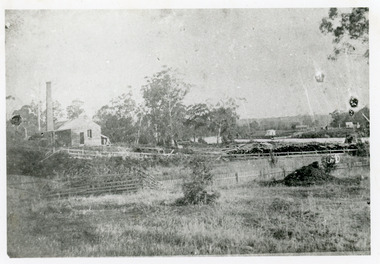
 Phillip Island and District Historical Society Inc.
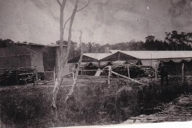
Photograph, Anderson Family, 1869
Brickworks situated on large farming area. Built soon after his arrival on Phillip Island in 1868.Brickworks in rural setting. Slender tree trunks in foreground alongside river. Post and wire fence with slip-rail gate. Large brick building and pavilion-type sheds with canvas awnings. Wood piled up outside.local history, photography, photographs, slides, film, buildings, historic, brick works of robert anderson snr, at phillip island, black & white photograph, mrs emma anderson jacobs -
Glenelg Shire Council Cultural Collection
Card - Portland Express Etching - Portland of Old, Irene Bartlett, artist, n.d
White card, Portland Express etching from original pen and ink sketch by Irene Bartlett. William Dutton's farm near mouth of Surrey River at Narrawong. Sketch on front, description of sketch and method of production on back -
Glenelg Shire Council Cultural Collection
Souvenir - Stubby Holder, n.d
Neoprene stubby holder. Originally cylindrical, open top, but has been cut down join and bottom removed, to make it wrap around. Royal blue outside, photo of Glenelg River at Nelson, yellow and white lettering.Front: 'A great place to Relax' - yellow NELSON Victoria - white -
 Halls Gap & Grampians Historical Society
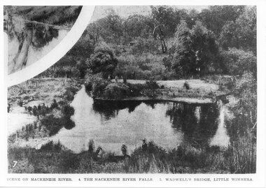
Photograph - B/W
This is the pondage below Wartook Lake embankment. The photo is from the Weekly Times. Oddly, the inscription on the bottom of the photo does not appear to relate to the images.Photo shows a river with four people standing on a sandy bank. Four other people can be seen in the forgrouns standing on the near bank. A smaller inset at the top left corner seems to show a tee reflected in water.scenery, mackenzie river -
4th/19th Prince of Wales's Light Horse Regiment Unit History Room
Booklet, Army Training Memorandum (War) (Australia) No 27, 22 Nov 1943
One of a series produced during World War 2All paper stapled memorandum distributed to each officer containing notes on Japanese hand grenades and mines, Intelligence bulletins from operations on various fronts, methods of transporting equipment across rivers and points on unarmed combat. booklet, army intelligence, world war 2 -
 Orbost & District Historical Society
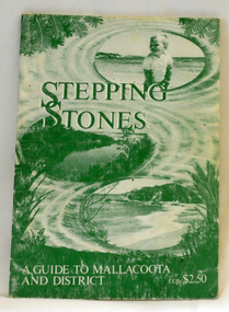
book, Stepping Stones, 1986
This book was compiled in 1983 by Chris Smyth, Isabel Baltvilks, Lorelle Roberts and Maurice Roberts for the Friends of Mallacoota as a guide to Victoria's eastern corner. Friends of Mallacoota is a group of volunteers, established in 1983, aiming to sustain the character of Mallacoota and its surrounds by protecting and caring for the natural environment. This book is a useful guide to Mallacoota's history and environment.A stapled, 40 pp, paperback book, titled "Stepping Stones A Guide to Mallacoota". The cover is green with a background drawing of a beach and river at Mallacoota. It is priced at $2.50. It contains descriptions, history, maps, black/white photographs and drawings.Stamped on inside cover - MAREEBA LODGE 59 MIRRABOOKA ROAD MALLACOOTA 3983 It has telephone details. mallacoota friends-of-mallacoota stepping-stones -
 Federation University Historical Collection
Banner, Chinese Calligraphic Banner, 10/08/1995
Presented to the Ballarat School of Mines from Changzhou Educaiton Delegation. A Chinese calligraphic banne a a famous poem 'On the Stork Tower' written in the Tang Dynesty by Wang Zhihuan. The Sun along the mountains bows; The yellow river seawards flows. You will enjoy a grander sight; By climbing to a greater height. wang zhihuan, poem, tang dynasty, stork tower, changzhou, chine, calligraphy -
 Bendigo Historical Society Inc.
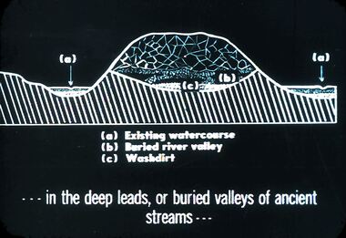
Slide - DIGGERS & MINING. DIGGERS AND MINERS, c1850s
Diggers & Mining. Diggers and miners. . . . In the deep leads, or buried valleys of ancient streams . . . (a) Existing water course (b) Buried river valley (c) Washdirt Markings: 22 994:LIF I. Used as a teaching aid.hanimounteducation, tertiary, goldfields -
Bendigo Historical Society Inc.
Map - CAMPBELL COLLECTION: BENDIGO AND DISTRICT MAPS, 9-4-29
Map. Campaspe, Parish of Kimbolton, Scale 20 chains to 1 inch. Total area 4117 acres, Campaspe River, Prepared in W.P.B. by W.J.Galbraith from Parish and Assessment Plans. (number 384 in map cupboard 1)W.J.Galbraithmap, bendigo, agricultural lands -
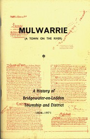 Bendigo Historical Society Inc.
Book - MULWARRIE A TOWN ON THE RIVER A HISTORY OF BRIDGWATER-0N-LODDON TOWNSHIP AND DISTRICT 1836-1971, 1971
'Mulwarrie' (A Town on the River). A History of Bridgewater-on-Loddon Township and District 1836-1971. Publisher: Jim Lowden Printing, Kilmore 3601. 80 pages. Photographs & illustrations. Bridgewater-on -Loddon History. Inscriptions: Bendigo Historical Society.Back to Bridgewater Committee 1971history, bridgewater -
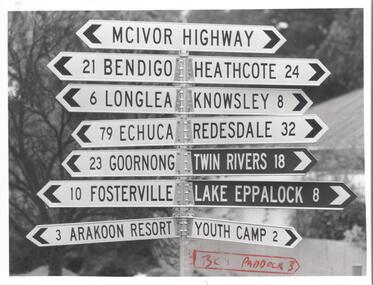 Bendigo Historical Society Inc.
Photograph - BENDIGO ADVERTISER COLLECTION: SIGN POST AT AXEDALE, 16/06/1993
Sign post at Axedale on the McIvor Highway indicating the distance to nearby places. Places named: Bendigo, Heathcote, Longlea, Knowsley, Echuca, Redesdale, Goornong, Twin Rivers, Fosterville, Lake Eppalock, Arakoon Resort, Youth Camp.Bill Hawkingregion, small towns, axedale -
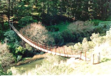 Hume City Civic Collection
Photograph
The original swing bridge was built across the Deep Creek in 1854 to allow the Daniel family to visit the Dickens sisters. It was renewed in later years and was used by Bulla children until the school closed in 1995.A coloured photograph of the swing bridge which straddles the Deep Creek at Bulla. The photograph shows the full length of the wooden and wire bridge from bank to bank. There is a thick row of conifers growing along the opposite river bank.bulla swing bridge, deep creek, daniel family, bulla state school, george evans collection -
Lakes Entrance Regional Historical Society (operating as Lakes Entrance History Centre & Museum)
Book, Land Conservation Council Victoria, Final Recommendations Gippsland Lakes hinterland Area, 1983
1980 report and recommendations of the Victorian Land Conservation Council, for the balanced use of public land in teh gippsland Lakes Hinterland includes reserves schools forests rivers foreshores and other public sites. Map and diagrams added.topography, parks, waterways -
Whitehorse Historical Society Inc.
Document, Establishment of a German settlement
Establishment of a German settlement at Port Phillip : extract from 'Westgarthtown : The German settlement, by Robert WuchatschEstablishment of a German settlement at Port Phillip : extract from 'Westgarthtown : The German settlement, by Robert Wuchatsch plus extracts from 'From Hamburg to Hobson's Bay' by T.A. Darragh and Wuchatsch and 'The Northcote side of the river' by Andrew Lemon.Establishment of a German settlement at Port Phillip : extract from 'Westgarthtown : The German settlement, by Robert Wuchatschgermans in australia, westgarthtown, schwerkolt, johann august, wuchatsch, robert, darragh, t.a., lemon, andrew -
 Lakes Entrance Regional Historical Society (operating as Lakes Entrance History Centre & Museum)
Photograph, 1895
Original creamery was at Bruthen, ,shifted to Johnsonville in March 1892, run by the Chilled Butter Company until 1899 with Mr G Lucas, last manager.Black and white photograph of the Johnsonville Creamery, situated on the southern bank of the Tambo River on Punt Road. A small timber building with gable roof, large chimney adjacent, punt landing and roadway on opposite bank. Johnsonville Victoriaretail trade