Showing 143117 items
matching colour-photograph
-
 Greensborough Historical Society
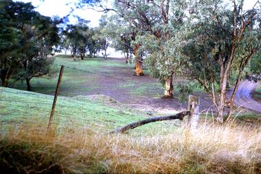
Slide - Photograph, John Ramsdale, Erosion on overgrazed property: Slide 124, 1990s
Photograph shows a fenced paddock and gum trees; this is sheet erosion on an overgrazed property near Whittlesea.Part of the John Ramsdale collection of slides and audio visual material.Colour photograph scanned from slide.No maker's marks. No caption on slide.whittlesea, erosion, farming -
 Greensborough Historical Society
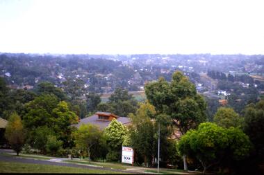
Slide - Photograph, John Ramsdale, Apollo Parkways: Slide 129, 1990s
Photograph shows a residential area among trees with auction sign in foreground. This is Apollo Parkways in the 1990s.Part of the John Ramsdale collection of slides and audio visual material.Colour photograph scanned from slide.No maker's marks. No caption on slide.apollo parkways, residential development -
 Greensborough Historical Society
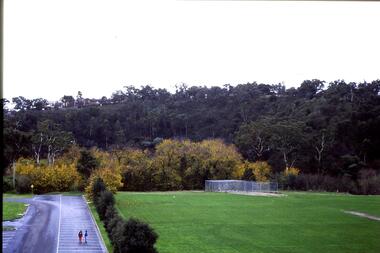
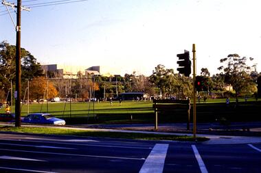
Slide - Photograph, John Ramsdale, Looking from Kalparrin to Partington's Flat: Slide 34, 1990s
Photograph shows a sports ground with cricket nets. Looking toward Partington Flat from Kalparrin.Part of the John Ramsdale collection of slides and audio visual material.Colour photograph scanned from slide.No caption. Printed maker's mark on slide "Kodak Kodachrome Slide"partingtons flat, cricket, public reserves -
 Greensborough Historical Society
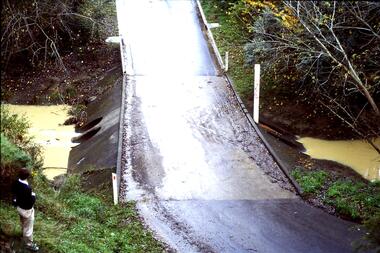
Slide - Photograph, John Ramsdale, Ford over Plenty River to Partington's Flat: Slide 72, 1990s
Photograph shows road or path over culvert. This is the ford over Plenty River to Partington's FlatPart of the John Ramsdale collection of slides and audio visual material.Colour photograph scanned from slide.No caption. Printed maker's mark on slide "Kodak Kodachrome Slide"ford over plenty river, plenty river, partington's flat -
 Greensborough Historical Society
Slide - Photograph, John Ramsdale, Greensborough Park: Slide 44, 1990s
Photograph shows Greensborough Park from the corner of St Helena and Diamond Creek Roads GreensboroughPart of the John Ramsdale collection of slides and audio visual material.Colour photograph scanned from slide.No maker's marks. No caption on slide.greensborough park, st helena road greensborough, diamond creek road greensborough -
 Greensborough Historical Society
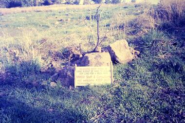
Slide - Photograph, John Ramsdale, Plenty Gorge sign: Slide 50, 1990s
Photograph shows a sign accusing MMBW of taking land for mega park - Plenty Gorge ParkPart of the John Ramsdale collection of slides and audio visual material.Colour photograph scanned from slide.No maker's marks. No caption on slide.plenty gorge metropolitan park, plenty gorge, melbourne and metropolitan board of works -
 Greensborough Historical Society
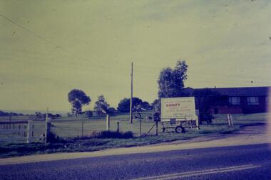
Slide - Photograph, John Ramsdale, Gorge Road sign: Slide 55, 1990s
Photograph shows house with anti-Plenty Gorge Park sign, Gorge Road South MorangPart of the John Ramsdale collection of slides and audio visual material.Colour photograph scanned from slide.No maker's marks. No caption on slide.plenty gorge, plenty gorge metropolitan park, melbourne and metropolitan board of works -
 Greensborough Historical Society
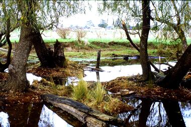
Slide - Photograph, John Ramsdale, Upper Plenty, possibly Yan Yean: Slide 56, 1990s
Photograph shows a rural scene after rain. The upper Plenty, possibly around Yan Yean.Part of the John Ramsdale collection of slides and audio visual material.Colour photograph scanned from slide.No maker's marks. No caption on slide.plenty river, yan yean -
 Greensborough Historical Society
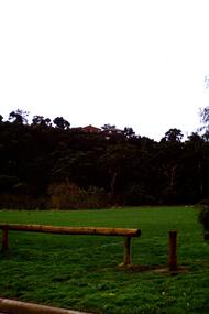
Slide - Photograph, John Ramsdale, Sports fields at Whatmough Park: Slide 78, 1990s
Photograph shows a park with pole fence in foreground. Part of the sports fields at Whatmough Park Greensborough.Part of the John Ramsdale collection of slides and audio visual material.Colour photograph scanned from slide.No maker's marks. No caption on slide.whatmough park, sports fields -
 Greensborough Historical Society
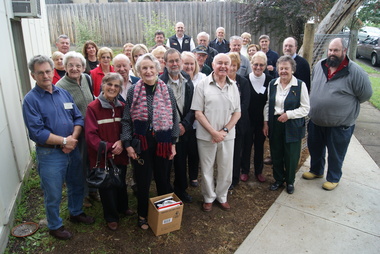
Photograph (Framed), Greensborough Historical Society, Greensborough Hisstorical Society Resource Centre Opening Day, Members, 22/10/2011
Group photograph of GHS members at the official opening of the GHS Resource Centre 22/10/2011Colour photograph in black plastic framegreensborough historical society -
 Greensborough Historical Society
Photograph - Digital image, Star Wars activity, Grimshaw Street Greensborough circa 1980s, 1980s
Photographs of local children participating in a Star Wars activity in Grimshaw Street Greensborough circa 1980s.Digital copy of 2 colour photographs.main street greensborough -
![Photograph - Digital image, Greensborough Cemetery [view of damage], 04/10/2011](/media/collectors/4f729f5697f83e03086015b8/items/54c4b3b12162f10704762f8a/item-media/54c4b3e62162f1070476341a/item-fit-380x285.jpg) Greensborough Historical Society
Greensborough Historical SocietyPhotograph - Digital image, Greensborough Cemetery [view of damage], 04/10/2011
View of damaged grave in Greensborough Cemetery 04/10/2011. Photograph taken by Jasmin Burge.Greensborough Cemetery was created when land was given for the cemetery by Mr William Poulter, a local settler, about 1864. The cemetery holds the graves of many of the early settlers in the district. The cemetery holds approximately 250 grave sites with 350 people buried there. Digital copy of colour photograph of cemetery.greensborough cemetery -
 Tatura Irrigation & Wartime Camps Museum
Photograph - original, Tatura Museum, 1988
Photograph of Historical Society Member Phil McTier working on verandah post during Museum restoration.Colour photograph of Phil McTier. 1988.on back: Phil McTiertatura museum -
 Glen Eira Historical Society
Photograph, Dalny Road, 7, Murrumbeena, 2001
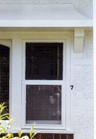
Originally labelled "Beauville Estate, Established 1936, Still Thriving 65 years on, 10th March 2001", the Beauville Estate Album contains colour photographs of houses in the Estate. They were taken around the time of the Beauville Estate’s 65th Heritage Celebration held on 10/03/2001 and donated to the Caulfield Historical Society shortly afterwards. Photographer unknown. City of Glen Eira’s Heritage Management Plan Vol 2 p79 (this is p84 of the pdf version) – HO12 Beauville Estate and environs, Murrumbeena: The Beauville Historic Area is important at the State level as the first large housing estate undertaken by the AV Jennings Construction Co, later Jennings Group Limited, Victoria’s largest home builder. It is important also as a very early estate development incorporating a range of features other than houses and including made roads, shops and recreation facilities. In this respect it was the forerunner of the comprehensively planned housing estate of the post war era. The estate is distinguished by its aesthetic values, as is the earlier and comparable Hillcrest Estate, which are formed by a combination of restrained diversity in house styles, with the exception of no. 30 in the emerging International style, and by a landscaped garden environment. Colour photograph of a section of a window of a white rendered brick house. The double hung window, with lead lights glass in the top pane, has a decorative bracket above it and unpainted feature variegated brown bricks below. "7' is on the edge of the frame. 7murrumbeena, houses, architectural styles, 1930's, inter war style, a.v. jennings, av jennings, jennings, brick houses, beauville estate, dalny road, sir albert victor jennings, a v jennings construction co, beauville estate heritage area, glen eira city council, architectural features, jennings group limited, land subdivision, beauville historic area, sash windows, lead lights, rendered houses, brick features -
 Lakes Entrance Regional Historical Society (operating as Lakes Entrance History Centre & Museum)
Photograph, 1999
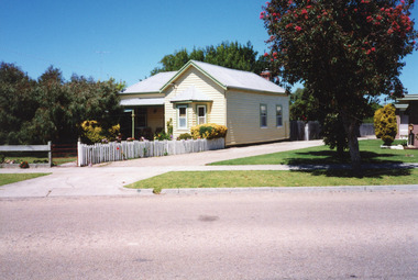
Built 1900c, cottage was made available for widow and children of Dougal Egan, lost when fishing boat Orme disappeared in 1909. After Mrs Egan married George South, cottage became known as the South House. Later resident Mrs Edith Rawlinson. Cottage restumped, refurbished 2011 / 2012.|Also Two colour photographs various viewsColour photograph of a timber cottage at 26 Church Street, with both hipped and gable iron roof. Triple sided bay window. Sash windows on west side, with window hoods. Western wall is on boundary of allotment. Lakes Entrance Victoriahouses, heritage study -
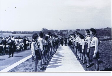 Greensborough Historical Society
Photograph - Digital Image, Opening of Shire of Diamond Valley offices 1972: Guides lined up to welcome official party, 26/02/1972
The official opening of the Shire of Diamond Valley offices in Greensborough on 26/02/1972. These photographs show local guides lined up to welcome official party, the Governor of Victoria, Sir Rohan Delacombe and Shire President Monte Vale. Photographs taken by a member of SDV staff.Photographs from of a folder of 21 colour photographsOn cover of folder "Opening of S.D.V. Office"shire of diamond valley, shire of diamond valley offices 1972, sir rohan delacombe, monte vale -
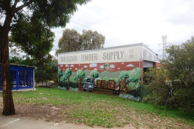 Greensborough Historical Society
Photograph - Digital Image, Marilyn Smith, Watsonia Timber Supply 2018, 04/12/2018
Watsonia Timber Supply, 58 Watsonia Road Watsonia. This business now trades as Rex Paine Timber and Hardware. This photograph show the mural on the side wall of the building.Digital copy of colour photographwatsonia shopping centre, rex paine timber and hardware, watsonia road watsonia, murals, watsonia timber supply -
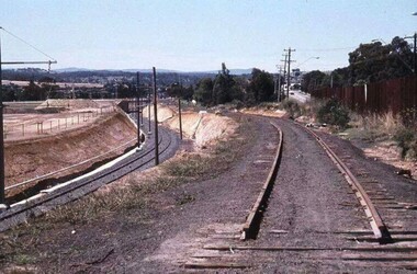 Greensborough Historical Society
Photograph - Digital Image, Watsonia Station, 1978c, 1978c
Watsonia Station during the duplication of the train line c1978. This photograph shows the existing rail line and the construction of the new tracks in the cutting. Looking toward Grimshaw Street.Shows the rural nature of the Greensborough area in the early 20th centuryDigital copy of colour photograph. trains, watsonia railway station -
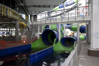 Greensborough Historical Society
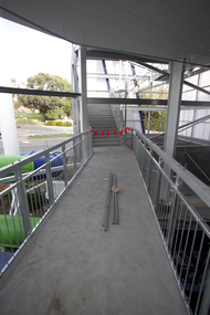
Photograph - Digital image, Watermarc under construction: Interior with part constructed waterslide, 18/05/2012
Watermarc under construction: Interior with part constructed waterslide. The redevelopment of the Greensborough Pool into the Watermarc aquatic centre is documented in this collection of photographs from the collection of Rosie Bray. These photographs taken on a ‘Community Consultative Committee’ walkthrough prior to completion of Watermarc, May 18 2012.Digital copy of colour photograph.watermarc, rosalie bray, greensborough swimming pool, swimming pools -
 Greensborough Historical Society
Photograph - Digital image, Watermarc under construction: Interior views of walkway and stairs, 18/05/2012
Watermarc under construction: Interior views of walkway and stairs. The redevelopment of the Greensborough Pool into the Watermarc aquatic centre is documented in this collection of photographs from the collection of Rosie Bray. These photographs taken on a ‘Community Consultative Committee’ walkthrough prior to completion of Watermarc, May 18 2012.Digital copy of colour photographs.watermarc, rosalie bray, greensborough swimming pool, swimming pools -
 Greensborough Historical Society
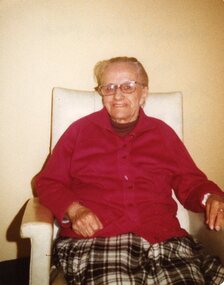
Photograph - Digital image, Jane Stock Finn 1970s, 1970s
Jane Finn (nee Stock) taken circa 1970s. Photographs from the collection of Peter Blackbourn, a descendant of the Chapman Stock family. Annotations to photos by Peter Blackbourn.Digital copy of colour photograph.peter blackbourn, jane stock finn -
 Greensborough Historical Society
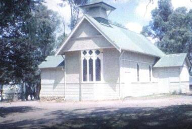
Photograph - Digital image, All Saints Greensborough, 1960c
This photograph shows the old timber church in Greensborough - All Saint's Anglican Church - now replaced by a modern church on the corner of Grimshaw Street and Church Street Greensborough.Digital copy of colour photograph.all saints anglican church greensborough -
 Greensborough Historical Society
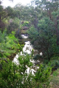
Photograph - Digital Image, Plenty River Greensborough May 2014 -1, 21/05/2014
The Plenty River flows south from Mt Disappointment before meeting with the Yarra River at Rosanna. These images taken in the Greensborough area. Photograph by Marilyn Smith 2014.Digital copy of colour photograph.plenty river, greensborough -
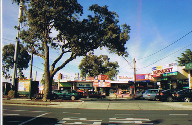
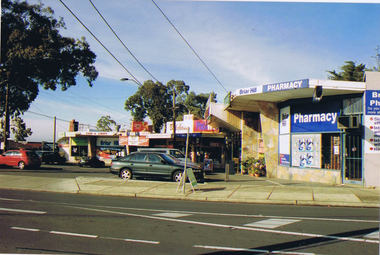
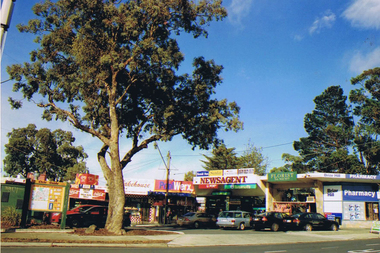
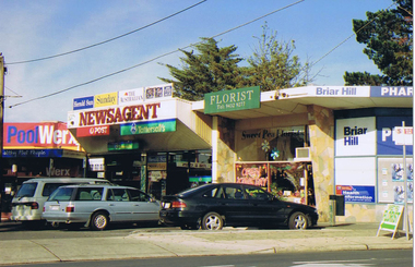 Greensborough Historical Society
Photograph - Digital image, Frank Solomon, Briar Hill shops 1, 2012_
Briar Hill shops are on the corner of Sherbourne Road and Mountainview Road Briar Hill. These photographs were taken by Frank Solomon and depict a small local shopping strip.Digital copy of colour photographbriar hill shops, briar hill -
 Greensborough Historical Society
Photograph - Digital image, Frank Solomon, Briar Hill shops 2, 2012_
Briar Hill shops are on the corner of Sherbourne Road and Mountainview Road Briar Hill. These photographs were taken by Frank Solomon and depict a small local shopping strip.Digital copy of colour photographbriar hill shops, briar hill -
 Greensborough Historical Society
Photograph - Digital image, Frank Solomon, Briar Hill shops 3, 2012_
Briar Hill shops are on the corner of Sherbourne Road and Mountainview Road Briar Hill. These photographs were taken by Frank Solomon and depict a small local shopping strip.Digital copy of colour photographbriar hill shops, briar hill -
 Greensborough Historical Society
Photograph - Digital image, Frank Solomon, Briar Hill Shops 4, 2012_
Briar Hill shops are on the corner of Sherbourne Road and Mountainview Road Briar Hill. These photographs were taken by Frank Solomon and depict a small local shopping strip.Digital copy of colour photographbriar hill shops, briar hill -
 Greensborough Historical Society
Photograph - Digital Image, Dog tags, Samuel Rich 1915-1918, 1915-1918
Identification tags belonging to Private Samuel Rich in World War 1. Other photographs taken by Samuel Rich during WWI are available at items 3973-3987.Digital copy of colour photographsamuel rich, world war 1, egypt -
 Greensborough Historical Society
Photograph - Digital Image, Marilyn Smith, Greensborough Grain Store, 183 Para Road. Architectural detail, 06/11/2017
This photograph shows architectural details of the building at 183 Para Road when it was used for Greensborough Grain Store; front door and bluestone steps, trellis and internal shelving.In 2017, the Greensborough Grain Store closed its Para Road premises and now trades online.Digital copy of colour photographgreensborough grain store, para road greensborough -
 Greensborough Historical Society
Photograph - Digital Image, Bundoora State School site, Redevelopment sign Bu1915, 01/10/2017
This photograph shows the Auction notice for the redeveloped site, formerly Bundoora State School. The original school building was incorporated into the redevelopment to provide a modern child care facility.Digital copy of colour photographbundoora primary school, bundoora state school, plenty road bundoora, childcare centre