Showing 27536 items
matching yarra-river
-
 Uniting Church Archives - Synod of Victoria
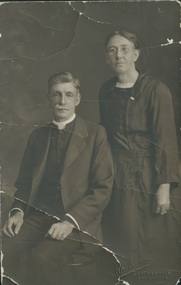
Photograph, Undated c.1920
James Rogers was born in Wallaroo, South Australia, but came to Sailor's Gully, Eaglehawk with his family as an infant. He was converted in a Salvation Army meeting at Bendigo. He became a member of the Primitive Methodist Church at Eaglehawk. He was stationed at: 1888 Murtoa; 1889 Hamilton; 1892 Melbourne, Collingwood; 1892 Beaconsfield; 1894 Penguin; 1900 Castlemaine; 1905 Dimboola; 1909 Geelong, Yarra St.; 1913 Kilcunda & Powlett River; 1917 Kyabram; 1920 North Melbourne; 1923 Brighton; 1928 Prahran; 1932 Supernumerary Hawthorn. Gaol Chaplain 1909 - 1912; Hospital Chaplain 1935 - 1936Died 2nd September 1937 Agnes Rogers (nee Caldwell) was born in 1867, married James Rogers in 1892 and died in 1951.B & W studio portrait of Rev James Rogers and Mrs Agnes Rogers (nee Caldwell)james rogers, agnes rogers, agnes caldwell, methodist, primitive methodist, eaglehawk, minister -
 Melbourne Tram Museum
Newspaper - Newspaper clipping, The Age Newspaper, "Trams CEO on a track to lift service", 01/07/2023
Interview with Yarra Trams CEO, Carla Purcell. Appointed to CEO role by Yarra Trams owner Kelli's Downer in November 2022, but started in April 2023 after returning from maternity leave. Tender process is underway for next tram franchise, currently worth $500M per year. Yarra Trams have operated the network for 13 years with current contract expiring at end of 2024. Tram patronage currently at 75% of pre-Covid levels. Melbourne's tram network currently consists of 475 trams, 250 km of track, 2300 employees servicing 200M annual passengers.Informative interview with Carla Purcell, CEO of Yarra TramsNewspaper clipping from the Age titled: "Trams CEO on a track to lift service"tramways, ceo, yarra trams, keolis downer-edi, tender documents, trams -
 Eltham District Historical Society Inc
Photograph, Fay Bridge, Toe-hold tree, Heritage Excursion, Killeavey, Laughing Waters Road, Eltham, November 2016
This scar or 'toe hold' tree fell over 50 yrs ago. It had died 50yrs before it fell and is estimated to be around 400 years old. It has a diameter of 1.3 m and is the only 'toe hold' tree in Nillumbik. Heritage Excursion - Killeavey Walk and Talk - Saturday 5th November Jane Woollard’s book Laughing Waters Road Art Landscape and Memory in Eltham devotes several chapters to the property Killeavey situated on the Yarra River at the end of Reynolds Road, Eltham. Jane has written about the natural history and indigenous history of the area and stories of the family who lived at Killeavey for many years. Killeavey was the home of Sir William Irvine, Victorian and Federal Parliamentarian and Supreme Court Judge. Later it was the home of his daughter Beatrice Morrison, a significant figure in the Eltham community. The original house was destroyed by fire and its replacement was demolished by Parks Victoria. Its sits high above the Yarra River and contains significant garden remnants. The surrounding bushland is valued for its significant plant communities. In September 2011 we visited Killeavey but without the benefit of the information more recently available from Jane’s research. We are fortunate that Jane will be joining us on this walk. There will be an extended stop at the house site for a discussion on the environment and history of the area. Inside the cover panels of Jane’s book is a reproduction of the complete artwork from ‘The Symbiogenesis Project: Laughing Waters 2011 by Aviva Reed and Paul Kalemba, as displayed in the Eltham Town Centre. This walk will start at 2 pm on Saturday 5th November at the corner of Laughing Waters and Overbank Roads. - EDHS Newsletter No. 230 October 2016fay bridge collection, 2016-11-05, activities, eltham, eltham district historical society, heritage excursion, kileavey, laughing waters road, parks victoria, cameron beardsall -
 Federation University Historical Collection
Newspaper, Overland Telegraph Centenary, 1972, 1972
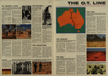
.1) Overland Centenary Supplement to The Australian. Six pages of information and images including the Roper River Camp, First Telegraph Pole at Port Darwin, Route of the Overland Telegraph, Australian Telecommunications Development Association, Alice Springs, Frew's Ponds. Charles Todd, Alice ToddFrank Kraegen, Pony Express. .2) 'The O.T. Line' - four page coloured news shhet published of by the Australian Post Office for the Overland Telegraph Line Centenary, 22 August 1972. Includes articles and images such as J.A.G. Little (Darwin Poatmaster), Robert Patterson, Charles Todd, A.J. Mitchell (surveyor), Maps of the sections (Begot's contract, Central Sections, Darwent and Dalwood contract, Patterson contract), planting of the first pole at Darwin, Roper River Camp, Charles Todd, Alice Todd, Alice Springs Repeater Station, Grave of Kavenagh, Roper River, Frank Kraegem, Maryvale station.roper river camp, telegraph pole, port darwin, overland telegraph route, australian telecommunications development association, alice springs, frew's ponds, charles todd, alice todd, frank kraegen, pony express -
 Kew Historical Society Inc
Photograph - Bridge over the Tambo River, 1926
Henry Beater Christian (1886-1962) , was a descendant of one of the earliest settler families in Kew. Employed at the Kew Asylum as a 'public servant', he was a skilled amateur photographer, photographing numerous scenes in Kew and on his travels around Victoria. The majority of his photographs date from 1916 to 1929. His finest photographs are housed in two photograph albums. Digital copy of a photograph from page 31 of the 47-page photograph album containing 261 gelatinous silver images, loaned by Diane Washfold with permission given to digitise and hold a copy in our collection. John Chapman has written in 'Bushwalking Clubs - A Brief History', about the establishment in Victoria of the first bushwalking club in 1888, and the popularisation of bushwalking during the interwar period. Henry Christian's 'walks' appear to have been undertaken solely or with a companion/s. This black and white photo is part of a group of six photos taken on an 18 kilometre walking trip between Bruthen and Swan Reach in East Gippsland in 1926. The route of the walk followed the Tambo River. The photographer has focussed the view on a ruined bridge, presumably caused by a flood, crossing the river. Sections of the left hand pier and span can be seen in the river."BRUTHEN TO SWAN REACH 1926"henry beater christian (1886-1962), landscape photography, christian-washfold collection, photograph albums, bushwalking, bruthen, swan reach, tambo river, east gippsland -
 Orbost & District Historical Society
album, Cameron, Alex, C1898
The photographs in this album were taken by Alex Cameron in 1898. The captions have been hand-written' Owned by Alexander Cameron who arrived in Australia in 1853. Alexander Cameron ("Big Alex") was an early settler on the Snowy River flats. he worked the paddle steamer Cheviot for a while, having a wharf and sheds on the Snowy River in 1900. Later moved to Cann River. This item is part of the Mary Gilbert Collection.This item is associated with the Cameron family, earty settlers of Orbost. The photographs are pictorial records of early East Gippsland.A ohotograph album with red covers. It contains labelled photographs of East Gippsland. On the front cover a label has been glued on. "Taken by Alex Cameron 1898" is written in red pen.on front cover - KODAK on spine - hand written KODAKcameron-alex photographs-east-gippsland -
 Orbost & District Historical Society
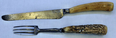
knife and fork, Joseph Rodgers & Son
The Tabbara Sawmill was located at Brodribb River, at the lower Snowy River estuary. In the early 1900’s bow saws and broad axes were used to selectively log the forest. Ox driven carts pulled the logs to the Snowy River; the logs were floated downstream to the steam powered mill. The PS Curlip steamboat, transported the timber to growing townships, for schools, houses and farms. The mill closed in 1903. Knife and fork with steel blades and bone handles..Knife - Joseph Rodgers & Son Cuttlers to her Majestyknife fork cutlery domestic-item rodgers-joseph -
 Tatura Irrigation & Wartime Camps Museum
Photograph, Paddle Steamer "Arbuthnot", 1986
Paddle Steamer "Arbuthnot", purchased by the Shire of Rodney to be restored using unemployment relief funding. Located on Goulburn River, upstream of Shepparton. Photo taken 1986 during river flooding. Now restored at Echuca.|Rodney Shire -
 Greensborough Historical Society
Photograph - Digital Image, River's up on Greensborough Bridge, 1910c
Plenty River in flood at old Greensborough bridge.Digital copy of black and white photograph.plenty river, floods -
 Ballarat Heritage Services
Photograph - Black and White Photograph, Tom Fitzgerald at Tarrone Starion
Torrone Station was on the Moyne River near Koroit. A black and white photograph with Tom Fitzgerald and his horse at Torrone Station. Many rabbits hang in the background.tom fitzgerald, torrone station -
 Port Fairy Historical Society Museum and Archives
Photograph - Postcard, Wm. Thompson
Port Fairy views - gardens, river, beachMontage of 5 Photographs headed with a large flourishing banner announcing Greetings from Port Fairy (postcard)published by Wm.Thompson Port Fairy- Greetings from Port fairy,View in the gardens Port fairy ,Government wharf Port Fairy Bathing boxes Port Fairygardens, river, beach, crags, botanical gardens, bathing boxes, battery hill, wharf, government wharf, moyne river, port fairy -
 Orbost & District Historical Society
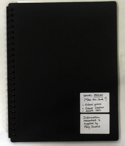
folder, Daniel Moylan (Dan the Cook), October 2012
This research record was part of a thesis that Mary Doland was preparing.This record is an excellent research tool for the study of the Indigenous history of Orbost.A 38 pp black spiral bound plastic folder containing a CD and research evidence compiled by Mary Doland on the topic of Dan Moylan, known as "Dan the Cook". He was speared to death in 1851 at Orbost Station, Snowy River.handwritten on a white label - Daniel Moylan handwritten on a white label below -Information researched and supplied by Mary Doland (Dan the Cook) Orbost grave Orbost station death 1851daniel-moylan aboriginal-history-orbost -
 Bendigo Historical Society Inc.
Photograph - BENDIGO HISTORICAL SOCIETY COLLECTION: KENNEDY'S OLD STABLE BUILDING , BARNADOWN
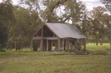
Colour photograph of Kennedy's old stables, Barnadown, situated near the Burke and Wills Memorial site. Shed has timber uprights and iron roof, no cladding on the walls. Large trees behind. Property is situated near the Campaspe River.agriculture, farm, kennedy's woolshed -
 Port Melbourne Historical & Preservation Society
Photograph - Nairana, 15 Jan 1942
"Nairana" probably in the Derwent River (?). Turbine vessel built just before WWI and commandeered by British Government as an aircraft carrier. Later ferry to Tasmania and went around west of Station Pier, came to Australia c 1920/21.maritime, transport - shipping, nairana -
 El Dorado Museum Association Inc.
Photograph (item) - Digital Image
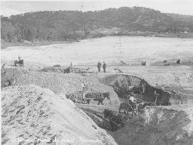
Altering course of Reedy Creek, El Dorado. Cocks Pioneer Electric Gold & Tin Mine Company was formed in 1899. The company's first power station, located at the eastern end of the valley began operating with its 340 Kilowatt steam-powered generator. By 1909, from 2,500,000 cubic yards worked, reported recovery was 17,284 ounces of gold and 224 tons of tin ore. By 1909, Cocks Pioneer’s power plant had become inadequate and uneconomical. The barge was floated downstream about a mile, but lost time caused the operations to cease. Following testing, a new mine was established by diverting Reid's Creek at a cost of £25 000. Settling dams were built, one of which held 1,935,900 cubic feet. Sold earth banks, built against a wall of stringy bark saplings constructed and laced with vertical props, were built. In 1914, the company was reformed as Cock’s Pioneer Gold and Tin Mines NL, another power station was constructed at the western end of the township, near the junction of Clear and Reid's Creeks. From 6,800,000 cubic yards of material processed, the returns were 64,397 ounces of gold and 855 ton of tin. Cocks Pioneer mine then moved the barge downs stream and continued sluicing. In 1929 Cocks Pioneer Electric Gold and Tin Mining Company ceased operations due to a drop in values. Cock’s Pioneer Gold and Tin Mines NL carried on large-scale hydraulic sluicing operations until 1941. Handwritten across the front: 'Altering course of creek. Eldorado'mining, gold, tin, sluicing, reedy creek, cocks pioneer, el dorado, eldorado, men, horses -
 Victorian Aboriginal Corporation for Languages
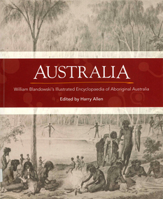
Book, Harry Allen, Australia : William Blandowski's illustrated encyclopaedia of Aboriginal Australia, 2010
William Blandowski was an explorer, natural scientist and artist who led a Victorian government expedition to the junction of the Murray and Darling Rivers from 1856 to 1857. This is the first publication in English of his nineteenth century illustrated encyclopaedia of Aboriginal life.Maps, b&w illustrationsaboriginal australian history, pictorial histories, william blandowski -
Victorian Aboriginal Corporation for Languages
Book, Harry Allen, Australia : William Blandowski's illustrated encyclopaedia of Aboriginal Australia, 2010
William Blandowski was an explorer, natural scientist and artist who led a Victorian government expedition to the junction of the Murray and Darling Rivers from 1856 to 1857. This is the first publication in English of his nineteenth century illustrated encyclopaedia of Aboriginal life.b&w illustrations, mapswilliam blandowski, pictorial works -
Lakes Entrance Regional Historical Society (operating as Lakes Entrance History Centre & Museum)
Book, Gippsland Heritage Journal - issue 23, 1999
This issue contains articles on the McMahon brothers voyage to Sydney by rowing boat, Dorothy Humphreys Soprano, Photographers Bert Boardman and Neil Macfarlane, Aboriginal historical sites on the Snowy river, Wilson's Promontory National Park, Crosslea Hphotography, aboriginals, ships and shipping -
Lakes Entrance Regional Historical Society (operating as Lakes Entrance History Centre & Museum)
Book, Refshauge W F, Tracing your Family History in Australia, 2012
An intriguing account of the authors search for the identity of Banjo Paterson Man from Snowy river through research into newspapers official records, manuscripts,books and articles, as well as legendary accounts from High Country inhabitants his life isbibliography, animals, heritage -
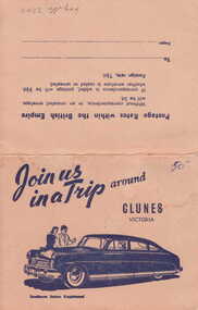 Clunes Museum
Photograph
PICTURESQUE SOUVENIR OF CLUNES. A FOLDER OF 8 PHOTOS CONSISTING OF VIEWS OF CLUNES 1. 4 PANORAMAS 2. CLUNES HOSPITAL 3. OLD POST OFFICE 4. TALLAROOP RIVER CLUNES 5. 2 OF FRASER STREET, CLUNESJOIN US IN A TRIP AROUND CLUNESlocal history, photography, photographs, township & buildings -
 Lakes Entrance Regional Historical Society (operating as Lakes Entrance History Centre & Museum)
Photograph, 1911
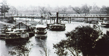
Black and white photograph showing P S Tanjil, S S Gippsland and dredge Pioneer at Bairnsdale wharf, steamer J C D at opposite bank. Early road bridge across Mitchell River. Bairnsdale Victoriaships and shipping, waterways, vegetation -
 Lakes Entrance Regional Historical Society (operating as Lakes Entrance History Centre & Museum)
Postcard, Segerberg and Bulmer, 1909
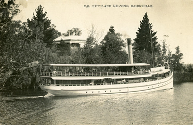
S S Gippsland was launched at Paynesville 1908. Letter on back mentioning 'Our New Boat'Black and white postcard print showing S S Gippsland in Mitchell river at Bairnsdale, shows three pine trees, large house vegetation on eastern bank, ship leaving Bairnsdale newly painted. Lakes Entrance VictoriaS.S. Gippsland Leaving Bairnsdalevegetation, waterways, ships and shipping -
 Lakes Entrance Regional Historical Society (operating as Lakes Entrance History Centre & Museum)
Photograph, Bulmer H D, 1923c
Second copyBlack and white photograph showing aerial view of the entrance to the Gippsland Lakes, shows Cunninghame Arm, North Arm, Reeves River and Hopetoun Channel, Rigby Island and Snake Island, the barrier on right foreground. Lakes Entrance Victoriawaterways, islands, aerial photograph, fishing industry, coast -
 Lakes Entrance Regional Historical Society (operating as Lakes Entrance History Centre & Museum)
Photograph, 1950c
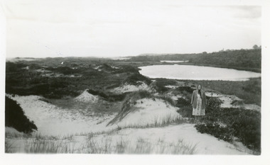
Also enlargement 15x25cmBlack and white photograph of the Warm Holes, from the sand hummocks looking west. The Warm Holes are the remnant of Reeves River, the original waterway from the Gippsland lakes to the natural entrance. Lady with shawl in foreground. Lakes Entrance Victoriatourism, waterways, topography -
 Lakes Entrance Regional Historical Society (operating as Lakes Entrance History Centre & Museum)
Photograph, 1920
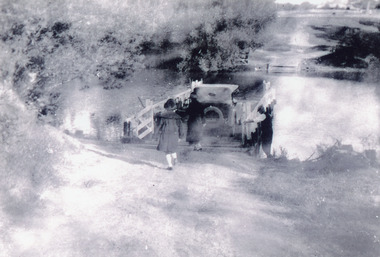
Black and white photograph showing two females and one male and car using punt to cross rive, Punt man loosening guide chains in preparation for crossing. Shows both banks of Tambo River at Tambo Upper Victoriaboats and boating, waterways -
 Bendigo Historical Society Inc.
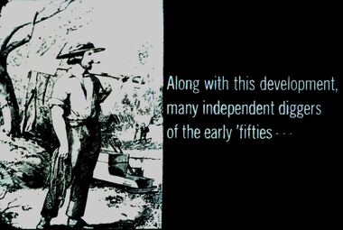
Slide - DIGGERS & MINING. DIGGERS AND MINERS, c1850s
Diggers & Mining. Diggers and miners. Along with this development, many independent diggers of the early 'fifties' - - - Slide shows a miner caring a shovel and a rope. A cradle by the river in the background. Markings: 30 994:LIF I. Used as a teaching aid.hanimounteducation, tertiary, goldfields -
 Kew Historical Society Inc
Map, Robert Russell, Map Shewing the Site of Melbourne and the Position of the Huts & Buildings Previous to the Foundation of the Township by Sir Richard Bourke in 1837
Map shows the first layout of Melbourne by Government surveyor Robert Russell, who accompanied Governor Richard Bourke in 1837. The surveyed blocks extend from present-day Flinders Street to Lonsdale Street, and Spring Street to Spencer Street, with extensive vacant land west to a salt lake (afterwards Batman's Swamp, later drained), north beyond Flagstaff Hill and south towards South Melbourne. Vegetation coverage is indicated, and tracks and existing buildings and cultivated land are shown.Printed map was created by Day & Haghe, Lithographers to the Queen, sometime after 1838, when the company received its Royal appointment. Copies of the 1837 map exist in several major map collections in Australia; most are uncoloured. This particular map is the earliest in the Kew Historical Society's map collection. It is a nationally significant artefact. Black and white lithographed map hand-coloured in blue and yellow gouache of the town of Melbourne in 1837. In contrast to the original lithograph, the river and the township blocks are coloured blue and yellow. A similar, partly coloured copy is in the collection of the University of Melbourne.maps - melbourne - 1830s, governor sir richard bourke, robert russell - surveyor, cartography -
Beechworth Honey Archive
Map- Albury/Wodonga
(5x) Map centred on Albury and Wodonga. Shows Albury and Wodonga, Murray River, Hume Highway, Murray Valley Highway and Riverina Highway. Scale 1:50,000. Paper is white on back and yellow on front. Ca 1974-1975 Labelled 'Albury series R 652'map, albury, wodonga, paper, beechworth honey -
 Wodonga & District Historical Society Inc
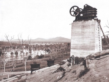
Album - Hume Reservoir Australia Album - Quarry plant being erected September 1921, 1927
This set of photos is from a leather bound album bearing the inscription "HUME RESERVOIR AUSTRALIA" plus 'The Rt. Hon. L. C. M. S. Amery, P. C., M .P.' all inscribed in gold. It was presented to The Rt. Hon. L. C. M. S. Amery, P. C., M. P, Secretary of State for Dominion Affairs on the occasion of his visit to the Hume Reservoir on 2nd November 1927. This album is of local and national significance as it documents the planning and development of the Hume Reservoir up to 1927. It was the largest water reservoir in the British Empire. The album records the pioneering engineering work that went into its construction.DEPARTMENT OF PUBLIC WORKS, N.S.W. RIVER MURRAY WATERS SCHEME. HUME RESERVOIR. 7. Quarry plant (New South Wales) being erected, September 1921. Murray Flats (in foreground) and Mitta Mitta Flats (beyond) flooded.hume reservoir australia, river murray waters scheme, quarry plant hume -
 Bendigo Historical Society Inc.
Postcard - Alice McGregor Postcard Collection, 1900 - 1920
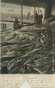
Alice McGREGOR Born: 1908; unknown parents. Possibly adopted by the Salter family? Electoral Roll 1936: Highland Terrace Kangaroo Flat. Alice Mary Salter and William Robert Salter living together; presumed to be sister and brother. William Robert Salter was killed in a MVA in Bendigo in 1937 aged 26. In Victoria in 1938, Alice Mary Salter married James Thomas McGregor (born Victoria 1917, died Victoria 1983, buried Fawkner Cemetery) Lived: 1968; 22 Wade Street Golden Square Alice McGregor Died: 1999 aged 91 at Anne Caudle Centre, Bendigo Buried: Kangaroo Flat Cemetery See additional research. Postcard Album of Alice McGregor contained 86 post cards.Postcard Album of Alice McGregor containing 86 post cards. See 1400 Colour image of fish on Cannery Wharf, Fraser River, British Columbia, Canada 4 people overlooking a vast pile of fish. Wharf in background Addressed to Miss A. Stapleton, Arcade, Bendigo, Victoria, Australia Sender - Harold Nation, Cranbrook, British Columbia, Canada dated Oct 2 '05 postcard, collector, alice mcgregor