Showing 11138 items
matching planning
-
 Eltham District Historical Society Inc
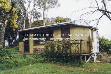
Photograph - Colour Print, Alan Marshall's bungalow, 13 Park West Road, Eltham, 22 July 1993
From 1955 Alan Marshall's home was a bungalow at the rear of his sister's house at Eltham. The first bungalow burnt down. Its replacement shown here still stands. In March 2020 the property was sold. It was last sold previously in November 1982. No mention was made in the advertising regarding the heritage protected bungalow in the rear yard and advertising material presented it as having future potential to develop STCA (Subject To Council Approval). Concerned local members of the community alerted to EDHS to the pending upcoming sale and Council was also alerted to the sale and the potential risk presented to the heritage protected bungalow. In 2021 an updated amendment, C133nill, was made to the Nillumbik Planning Scheme in response to a planning application to develop the property following its sale. The Minster of Planning approved and gazetted the Amendment. Gazettal occurred on 25th November 2021. A copy of the gazetted Amendment is available on website of the Department of Environment, Land, Water and Planning at www.planning.vic.gov.au/schemes-and-amendments/browse-amendments. It was last updated March 2022.Colour photo print 10 x 15 cm, originally stuck down on corflute for displayeltham, alan marshall, alan marshall bungalow, heritage assessment, heritage protection overlay, houses, nillumbik shire council, park west road, heritage overlay ho147 -
 Bendigo Military Museum
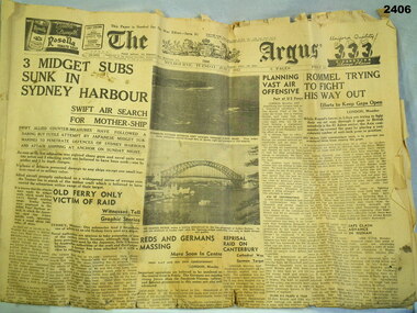
Newspaper - NEWSPAPER, ARGUS, Melbourne Argus, C. June 1942
The Argus, Melbourne Tuesday June 2 1942. 6 pages. Main headlines: - 3 midget subs sunk in Sydney Harbour - Rommel trying to fight his way out - No more beer for Germany - Planning vase air offensivedocuments - newspapers, military history, the argus -
 Flagstaff Hill Maritime Museum and Village
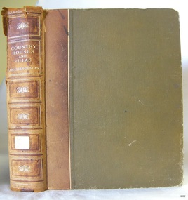
Book, Country Houses and Villas
This item is from the ‘Pattison Collection’, a collection of books and records that was originally owned by the Warrnambool Mechanics’ Institute, which was founded in Warrnambool in 1853. By 1886 the Warrnambool Mechanics’ Institute (WMI) had grown to have a Library, Museum and Fine Arts Gallery, with a collection of “… choice productions of art, and valuable specimens in almost every branch and many wonderful national curiosities are now to be seen there, including historic relics of the town and district.” It later included a School of Design. Although it was very well patronised, the lack of financial support led the WMI in 1911 to ask the City Council to take it over. In 1935 Ralph Pattison was appointed as City Librarian to establish and organise the Warrnambool Library as it was then called. When the WMI building was pulled down in 1963 a new civic building was erected on the site and the new Warrnambool Library, on behalf of the City Council, took over all the holdings of the WMI. At this time some of the items were separated and identified as the ‘Pattison Collection’, named after Ralph Pattison. Eventually the components of the WMI were distributed from the Warrnambool Library to various places, including the Art Gallery, Historical Society and Flagstaff Hill. Later some were even distributed to other regional branches of Corangamite Regional Library and passed to and fro. It is difficult now to trace just where all of the items have ended up. The books at Flagstaff Hill Maritime Village generally display stamps and markings from Pattison as well as a variety of other institutions including the Mechanics’ Institute itself. RALPH ERIC PATTISON Ralph Eric Pattison was born in Rockhampton, Queensland, in 1891. He married Maude Swan from Warrnambool in 1920 and they set up home in Warrnambool. In 1935 Pattison accepted a position as City Librarian for the Warrnambool City Council. His huge challenge was to make a functional library within two rooms of the Mechanics’ Institute. He tirelessly cleaned, cleared and sorted a disarrayed collection of old books, jars of preserved specimens and other items reserved for exhibition in the city’s museum. He developed and updated the library with a wide variety of books for all tastes, including reference books for students; a difficult task to fulfil during the years following the Depression. He converted all of the lower area of the building into a library, reference room and reading room for members and the public. The books were sorted and stored using a cataloguing and card index system that he had developed himself. He also prepared the upper floor of the building and established the Art Gallery and later the Museum, a place to exhibit the many old relics that had been stored for years for this purpose. One of the treasures he found was a beautiful ancient clock, which he repaired, restored and enjoyed using in his office during the years of his service there. Ralph Pattison was described as “a meticulous gentleman whose punctuality, floorless courtesy and distinctive neat dress were hallmarks of his character, and ‘his’ clock controlled his daily routine, and his opening and closing of the library’s large heavy doors to the minute.” Pattison took leave during 1942 to 1945 to serve in the Royal Australian Navy, Volunteer Reserve as Lieutenant. A few years later he converted one of the Museum’s rooms into a Children’s Library, stocking it with suitable books for the younger generation. This was an instant success. In the 1950’s he had the honour of being appointed to the Victorian Library Board and received more inspiration from the monthly conferences in Melbourne. He was sadly retired in 1959 after over 23 years of service, due to the fact that he had gone over the working age of council officers. However he continued to take a very keen interest in the continual development of the Library until his death in 1969. The Pattison Collection, along with other items at Flagstaff Hill Maritime Village, was originally part of the Warrnambool Mechanics' Institute’s collection. The Warrnambool Mechanics’ Institute Collection is primarily significant in its totality, rather than for the individual objects it contains. Its contents are highly representative of the development of Mechanics' Institute libraries across Australia, particularly Victoria. A diversity of publications and themes has been amassed, and these provide clues to our understanding of the nature of and changes in the reading habits of Victorians from the 1850s to the middle of the 20th century. The collection also highlights the Warrnambool community’s commitment to the Mechanics’ Institute, reading, literacy and learning in the regions, and proves that access to knowledge was not impeded by distance. These items help to provide a more complete picture of our community’s ideals and aspirations. The Warrnambool Mechanics Institute book collection has historical and social significance for its strong association with the Mechanics Institute movement and the important role it played in the intellectual, cultural and social development of people throughout the latter part of the nineteenth century and the early twentieth century. The collection of books is a rare example of an early lending library and its significance is enhanced by the survival of an original collection of many volumes. The Warrnambool Mechanics' Institute’s publication collection is of both local and state significance. Country Houses and Villas Comprising 'Country Cottages' & 'The House Beautiful' illustrated with plans and interior decorations by well known Architects Author: J H Elder-Duncan Editorial secretary of "The Architectural Review" Publisher: Cassell & Co Date: 1908Label on spine cover with typed text PAT F 728 ELD Pastedown front endpaper has sticker from Warrnambool Mechanics Institute and Free Library Front loose endpaper has a sticker from Corangamite Regional Library Service Front loose endpaper has a stamp from Corangamite Regional Library Service warrnambool, shipwrecked-coast, flagstaff-hill, flagstaff-hill-maritime-museum, maritime-museum, shipwreck-coast, flagstaff-hill-maritime-village, shipwrecked-artefact, book, pattison collection, warrnambool library, warrnambool mechanics’ institute, ralph eric pattison, corangamite regional library service, warrnambool city librarian, mechanics’ institute library, victorian library board, warrnambool books and records, warrnambool children’s library, great ocean road, country houses and villas, j h elder-duncan, the architectural review -
 Bendigo Historical Society Inc.
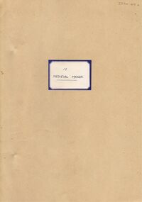
Document - LA TROBE UNIVERSITY BENDIGO COLLECTION: MEDIEVAL MANOR 13
A brown paper folder titled "Medieval Manor". A teaching plan to teach life in 'Medieval England'. From the files of Mr. L.J. Pryor. Former Principal of Bendigo Teachers' College. Donated to Education Resource Centre for archival use in 1992.bendigo, education, bendigo teachers' college, la trobe university bendigo collection, collection, bendigo, bendigo teachers' college, history, history - study and teaching, curriculum, mr. l.j. pryor, male, person, individual, education, education resource centre -
 Bendigo Historical Society Inc.
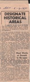
Newspaper - BENDIGO ADVERTISER SEPTEMBER 8, 1971 DESIGNATE HISTORICAL AREAS IN BENDIGO, 1971
Black & White Bendigo Advertiser Article September 9, 1971. Designate Historical Areas. Town Planning Officer Mr. B.S. Collins suggests that having areas of Bendigo designated as having historical significance would be especially useful for tourism.bendigo, newspapers, bendigo advertiser historical areas, previous number newspaper clippings folder 51-100 -
 Bendigo Historical Society Inc.
Map - CAMPBELL COLLECTION: BENDIGO AND DISTRICT MAPS, 16-4-29
Map. Kennington, Parishes of Sandhurst, Mandurang and Strathfieldsaye. Scale 20 chains to 1 inch. Total area 2918 acres. Prepared in W.P.B. from A. and C.L. Plans by W.J.Galbraith, 16-4-29. (number 394 in map cupboard 1)W.J.Galbraithmap, bendigo, allotments -
Bendigo Historical Society Inc.
Map - CAMPBELL COLLECTION: BENDIGO & DISTRICT MAPS, 22-3 29
Map. Marong, Parishes of Marong, Lockwood and Mandurang. Scale 20 chains to an inch. Total area 5106 acres. Crusoe Reservoir on right. Compiled in W.P.B. from Field Survey and Parish Plans (number 373 in map cupboard 1)G.W.Lmap, bendigo, allotments -
Bendigo Historical Society Inc.
Map - CAMPBELL COLLECTION: BENDIGO AND DISTRICT MAPS
Map. Marong, Parishes of Marong, Lockwood and Mandurang. Scale 20 chains to an inch. Total 5106 acres. Compiled in W.P.B. from Field Survey and Parish Plans. Crusoe Reservoir to the right of map. (number 362 in map cupboard 1)map, bendigo, parish plan -
 Bendigo Historical Society Inc.
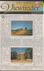
Newspaper - JACK PERRY COLLECTION: NEWSPAPER LIGHTNING HILL
Newspaper article, Bendigo Weekly, on Lightning Hill and Permanent Survey Markers, their importance in mapping, drainage and sewerage planning. Marker on Lightning Hill shows distance and direction to Mr. Ida Heathcote, Pyramid Hill, Mt. Moliagul and Mt. Korong.person, individual, jack perry, lightning hill, permanent survey markers, windmill hill -
Bendigo Historical Society Inc.
Map - CAMPBELL COLLECTION: BENDIGO AND DISTRICT MAPS, 6-4-28
Map. Sedgwick, Parishes of Strathfieldsaye, Lyell, and Sedgwick. Scale 20 chains to 1 inch. Total area 5372 acres. Prepared in W.P.B. from C.L.and A. Plans by W.J.Galbraith 6-4-28. (number 400 in map cupboard 1)W.J.Galbraith.map, bendigo, agricultural lands -
Port Melbourne Historical & Preservation Society
Booklet - Radiation monitoring plan for visit to Station Pier of nuclear powered cruiser USS Long Beach, 1976
Radiation monitoring plan for the visit of nuclear powered cruiser USS Long Beach to Station Pier, Port Melbourne 30 October to 6 November 1976 (prepared by the Australian Atomic Energy Commission and the Australian Radiation Laboratory of the Department of Health)melbourne harbor trust - port of melbourne authority, uss truxton - nuclear powered cruiser, uss long beach - nuclear powered cruiser -
Port Melbourne Historical & Preservation Society
Plan - Annotated and handcoloured by Peter Libbis to indicate his research into Libbis family residences and hotels on copy of a section of an MMBW map, Melbourne and Metropolitan Board of Works, c. 1980s
Peter LIBBIS obtained these copies from the MMBW when he researched his family history in the 1980s. He has annotated them, colour in hotels etc. Donated to Society in 1997.One of a group of 19 photocopies of various 20th century MMBW plans, annotated/coloured in to indicate residences of Libbis family and local hotels, by Peter LIBBIS in family and hotel research - Beach, Nott to Dow,South of Graham - date unknownbusiness and traders - hotels, built environment - domestic, transport - railways, melbourne and metropolitan board of works, libbis family -
Port Melbourne Historical & Preservation Society
Plan - Annotated and handcoloured by Peter Libbis to indicate his research into Libbis family residences and hotels on copy of a section of an MMBW map, Melbourne and Metropolitan Board of Works, c. 1980s
Peter LIBBIS obtained these copies from the MMBW when he researched his family history in the 1980s. He has annotated them, colour in hotels etc. Donated to Society in 1997.One of a group of 19 photocopies of various 20th century MMBW plans, annotated/coloured in to indicate residences of Libbis family and local hotels, by Peter LIBBIS in family and hotel research - Railway, Montague to Ingles Street (South Melbourne mostly)business and traders - hotels, built environment - domestic, transport - railways, melbourne and metropolitan board of works, libbis family -
Port Melbourne Historical & Preservation Society
Plan - Annotated and handcoloured by Peter Libbis to indicate his research into Libbis family residences and hotels on copy of a section of an MMBW map, Melbourne and Metropolitan Board of Works, c. 1980s
Peter LIBBIS obtained these copies from the MMBW when he researched his family history in the 1980s. He has annotated them, colour in hotels etc. Donated to Society in 1997.One of a group of 19 photocopies of various 20th century MMBW plans, annotated/coloured in to indicate residences of Libbis family and local hotels, by Peter LIBBIS in family and hotel research - Princes, Graham to Liardet (portion thereof; i.e. of 671.18)business and traders - hotels, built environment - domestic, transport - railways, melbourne and metropolitan board of works, libbis family, thomas libbis -
 Bendigo Historical Society Inc.
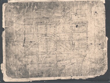
Photograph - WES HARRY COLLECTION: TOWNSHIP OF SANDHURST, 1854
Photograph of the Parish Plan of the Township of Sandhurst in 1854. It covers the area of the CBD from Mitchell (not named) to Bernal Streets and from the Bendigo Creek to Mollison St. ( other than Pall Mall and McRae streets, none of these parallel streets are named)place, bendigo, first survey, sandhurst, first survey, bendigo creek -
Tatura Irrigation & Wartime Camps Museum
Booklet, Internees at camp 1 Tatura, Hermann Junge, 1940's
Produced by internees at Camp 1, Tatura and intended for their and fellow internee use.Unbound, folded loose leave, booklet featuring head and shoulders black and white sketch of man on front cover. Below the name Hermann Junge is written. Typed on manual typewriter. Contains 2 maps and camp plans. 83 pagesHermann Jungehedlig docke, camp 1 tatura, hermann junge -
 Anglesea and District Historical Society
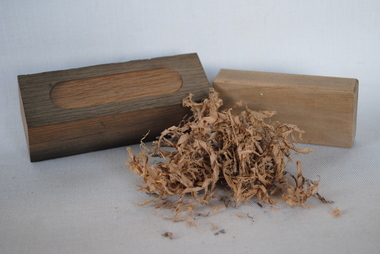
Items from ship "Lightning"
1. Rectangular block of wood with shallow lozenge shaped cut out on one side. 2. Rectangular block of wood with planed edges. 3. Shavings of white oak timber recovered from hull of "Lightning" contained in glass jar.1. and 2. have "Lightning" written on them.ss lightning -
Whitehorse Historical Society Inc.
Newspaper, Blackburn P-12 College To Proceed, 18/12/1991 12:00:00 AM
Minister for Education & Planning, Hon. Barry Pullen, approves proposal for Prep-Year 12 Government College in Blackburn.Minister for Education & Planning, Hon. Barry Pullen, approves proposal for Prep-Year 12 Government College in Blackburn. Proposal from Blackburn Secondary College, Blackburn High School, Blackburn North Primary School & Middlefield Primary School.Minister for Education & Planning, Hon. Barry Pullen, approves proposal for Prep-Year 12 Government College in Blackburn. pullen, barry, victoria. education department, blackburn secondary college, blackburn high school, blackburn north primary school, middlefield primary school, colleges, schools -
 Whitehorse Historical Society Inc.
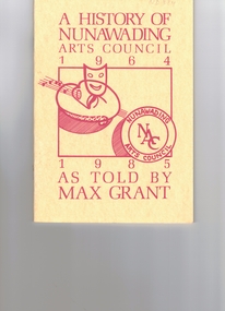
Pamphlet, A History of Nunawading Arts Council 1964-1985, 1985
A History of Nunawading Arts CouncilA History of Nunawading Arts Council 1964-1985,as told by Max Grant. A year by year account is given of the Nunawading Festival and the various orginations involved. Planning and development of the Nunawading Arts and Entertainment Centre is included. There is a list of Office Bearers for the period.A History of Nunawading Arts Council art exhibitions, art festivals, nunawading festival, nunawading arts council, nunawading arts & exhibition centre -
Whitehorse Historical Society Inc.
Map, Municipality of Nunawading, c1950
Plan No 234, compiled and photo-lithographed at the Melbourne and Metropolitan Board of Works under the direction of G.R. McGowan, Chief Surveyor.Plan No 234, compiled and photo-lithographed at the Melbourne and Metropolitan Board of Works under the direction of G.R. McGowan, Chief Surveyor. Covers the area each Side of Canterbury Road from Orchard Grove to Vernon Street. Includes detail of creeks.Plan No 234, compiled and photo-lithographed at the Melbourne and Metropolitan Board of Works under the direction of G.R. McGowan, Chief Surveyor. blackburn south, gardiners creek, blackburn, blackburn creeklands -
 Whitehorse Historical Society Inc.
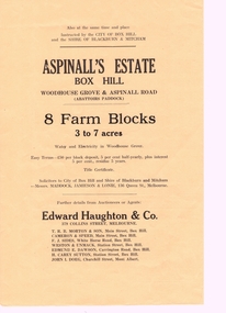
Pamphlet, Aspinall's Estate Box Hill, 1937
Pamphlet advertising 8 farm blocks on Aspinall Estate,Pamphlet advertising 8 farm blocks on Aspinall Estate, Box Hill on Woodhouse Grove and Aspinall Road, 27 October 1937. Sale was for the City of Box Hill and the Shire of Blackburn and Mitcham.. A plan is included. A list of other sales is on the verso.Pamphlet advertising 8 farm blocks on Aspinall Estate,auctions, aspinalls estate, abattoirs paddock, woodhouse grove, box hill north, aspinall road, mont albert, box hill, surrey hills, burwood, edward haughton pty ltd, t. r. b. morton & son, cameron and speed, f. j. sides, weston and unmacht, edmund dawson, h. carey sutton (estate agent), j. i. doeg, city of box hill, shire of blackburn and mitcham -
Whitehorse Historical Society Inc.
Document, Nunawading South State School
Documents relating to purchase of land to build Nunawading South State School. Land purchased from K.E. & L.A. Jones. Photocopies of photos of the land before and during building. Road Plan. Notice from Native Plants Preservation Society.nunawading south state school no. 4808, k.e. & l.a. jones, victoria. education department, native plants preservation society of victoria -
 Whitehorse Historical Society Inc.
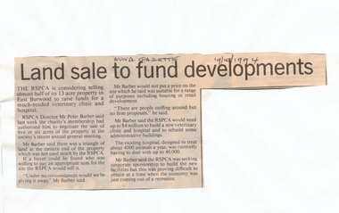
Article, Land sale to fund developments, 19/10/1994 12:00:00 AM
RSPCA plans to sell 5 or 6 acres of its East Burwood property at market value to help fund the new veterinary clinic and hospital.Newspaper article outlining RSPCA plans to sell 5 or 6 acres of its East Burwood property at market value to help fund the new veterinary clinic and hospital. The sum required to build the new hospital and clinic is $4 million. RSPCA plans to sell 5 or 6 acres of its East Burwood property at market value to help fund the new veterinary clinic and hospital. royal society for the prevention of cruelty to animals, burwood east, barber, peter, veterinary services, land sales -
 Whitehorse Historical Society Inc.
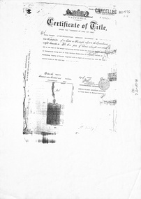
Legal record - Document, Forest Hill, 12/08/1913
Photocopy of Certificate of Title. Vol 3715 Fol. 742903 to Julius Draeger, 12 August 1913, for fifteen acres of land being part of Crown Portion 94, including plan of subdivision (P72294) cancelling title. [Contract of Sale ND567]Photocopy of Certificate of Title. Vol 3715 Fol. 742903 to Julius Draeger, 12 August 1913, for fifteen acres of land being part of Crown Portion 94, including plan of subdivision (P72294) cancelling title. [Contract of Sale ND567]Photocopy of Certificate of Title. Vol 3715 Fol. 742903 to Julius Draeger, 12 August 1913, for fifteen acres of land being part of Crown Portion 94, including plan of subdivision (P72294) cancelling title. [Contract of Sale ND567]glebe street, forest hill, land subdivision, draeger, carl julius otto, vicki street, bindy street, lee-ann street -
 Whitehorse Historical Society Inc.
Document - Planning Scheme Amendment, Former Town Hall, 1/11/1998
Whitehorse Planning Scheme amendment L21, Part 2 with explanatory report and covering latter from Department of Infrastructure to City of Whitehorse regarding changed requirements affecting former town hall building, 360 - 362 Whitehorse Road, Nunawading.city of whitehorse, victoria. department of infrastructure, whitehorse road, nunawading, no 360, municipal chambers, city of nunawading, whitehorse planning scheme, shire of blackburn and mitcham -
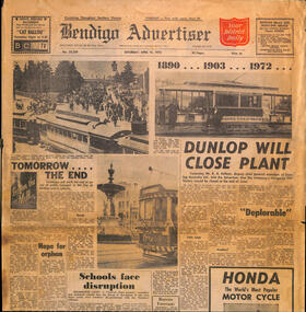 Ballarat Tramway Museum
Newspaper, Bendigo Advertiser, "Tomorrow the End", 15/04/1972 12:00:00 AM
Newspaper clipping from The Bendigo Advertiser 15/4/1972, titled "Tomorrow the End" reporting on the closure the following day of the Bendigo tramway system, Has a short history of the tramway and three photos of trams in Bendigo and the plans for the following day.closure, bendigo, sec -
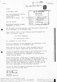
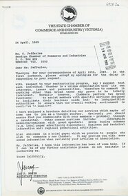 Bendigo Historical Society Inc.
Document - Bendigo Chamber of Commerce letter from the Victorian State Chamber of commerce re re-structure, 1989
The Bendigo Chamber of Commerce and Industry was constituted in 1886 with the vision to be the single voice for the business community across greater Bendigo. ‘Be.Bendigo’ is the trading name of the organisation ‘Bendigo Business Council’ which was formed in 2008 as a merger between two Bendigo business organisations: The Bendigo Chamber of Commerce and Central Victorian Business Network (CVBN). Upon the merger, Bendigo Business Council continued the functions of both the Chamber and CVBN by providing advocacy, networking and events to members and partners.Bendigo Chamber of Commerce letter from the Victorian State Chamber of commerce re re-structure. Dated 28 April 1989. Numerous printed pages outlining the plan of action for forming an independent Chamber of Commerce in Bendigo and developing a constitution.history, bendigo, bendigo chamber of commerce collection -
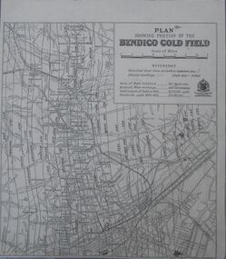 Bendigo Historical Society Inc.
Map - Bendigo Gold Field
Plan showing portion of the Bendigo goldfield. Area of main goldfield: 140 square miles. Deepest mine working: 4593' (Victoria quartz). Gold output of field to 1935: 20,775,000 ounces. Dividends paid 1870-1935: 10,740,000 pounds.map, goldfield, bendigo -
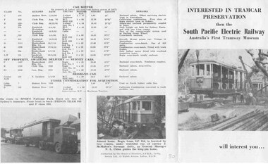 Ballarat Tramway Museum
Pamphlet, South Pacific Electric Railway, SPER - invitation and information, 1960
A folder pamphlet inviting inspection and participation to South Pacific Electric Railway Museum at National Park - 4 photos, outlining future plans, etc. folds into 3 portions - gives list of trams held at the time - early 60's.trams, tramways, tramway museums, sydney, tramcars, preservation -
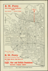 Kew Historical Society Inc
Map - Map of Kew and Hawthorn Districts
Map of Kew, East Kew and Hawthorn produced for a Kew Real Estate Agent, RW Perry. The map is undated.Two-colour map of Kew and Hawthorn Districts produced for by R.L. Jarrett for RW Perry, Real Estate & Insurance Agent. The map has unusual features such as a planned railway link from Kew Station to the former Outer Circle Railway. RW Perry / Real Estate & Insurance Agent, 602 High Street, East Kewmaps - kew (vic), maps - hawthorn (vic), r.w. perry, real estate agents -- kew (vic.)