Showing 10832 items
matching maps
-
 Ballarat Tramway Museum
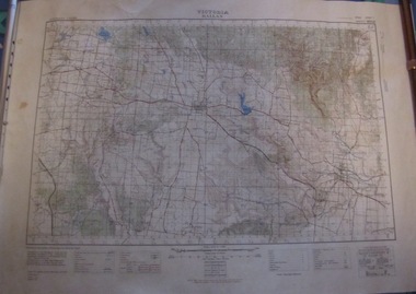
Map, Australian Survey Corps, "Victoria Ballan", 1933
Topographic map of the Ballan area - includes Bacchus Marsh and Bungaree, No. 837, Zone 7, Army Map, dated 1933, 1:63360. Shows rail lines, roads, elevations, contours. Collected with relevance to the Museum's association with the area, at Bungareetrams, tramways, bungaree, map -
 Greensborough Historical Society
Map, Victoria: Yan Yean, prep. by Australian Section of Imperial General Staff, 1935
Part of 1:63,360 series of survey mapsColour copy from original. Scale: 1: 63,360 (1 inch to 1 mile) 2 copiesRev. 1930 by Australian Survey Corps using RAAF Air Photos. yan yean -
 Greensborough Historical Society
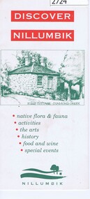
Leaflet, Nillumbik Shire Council, Discover Nillumbik, 2000c
Map and lists of attractions within the Shire of NillumbikDouble sided, folded seven times printed in red and greennillumbik -
Federation University Historical Collection
Plan - Plan (copy), Melbourne Road Ballaarat, 1857
This map shows the vicinity of the site of the Eureka Stockade. A3 black and whole photocopy of a plan of Ballarat's Melbourne Road. The plan shows Melbourne Road, Proposed Melbourne Road (later Eureka Street), Chamberlain Street, Queen Street, Allotments between Rodier Street and Stawell Street (William Collard Smith, J & T Oddie, F.A. Edward A. Wynne, David Fitzpatrick, Robert Walsh, Charles Spencer, Alfred Lester, Free Trade Hotel)william collard smith, oddie, wynne, fitzpatrick, walsh, spencer, lester, free trade hotel -
 Stawell Historical Society Inc
Photograph, H.M.A.S. Stawell Corvett Class -- Tour of Duty Map
Corvette H.M.A.S. STAWELL Tour of Duty Mapstawell ww2 -
 National Wool Museum
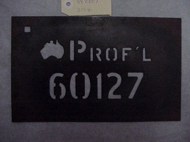
Stencil
Formica stencil, map of Australia, PROF'L 60127 .PROF' L 60127shearing, wool bales, stencil -
 Whitehorse Historical Society Inc.
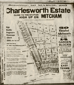
Document, Charlesworth Estate, 1913
Charlesworth Estate, Mitcham. 50 elevated allotments, 1/2 to 1 acre each and 14 garden blocks from 2 to 7 acres each. 1 March 1913.Brochure for auction of Charlesworth Estate, Mitcham. 50 elevated allotments, 1/2 to 1 acre each and 14 garden blocks from 2 to 7 acres each. 1 March 1913. Agents: Coghill & Houghton and H. Carey Sutton.Charlesworth Estate, Mitcham. 50 elevated allotments, 1/2 to 1 acre each and 14 garden blocks from 2 to 7 acres each. 1 March 1913.auctions, charlesworth estate, mitcham, quarry road, doncaster east road, burnett street, harrison street, whitehorse road -
 Whitehorse Historical Society Inc.
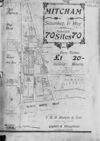
Document, Mitcham, ca 1920
Brochure for auction of 70 sites bounded by Mitcham, Doncaster East and Whitehorse Roads on 1 May ?1920.Brochure for auction of 70 sites bounded by Mitcham, Doncaster East and Whitehorse Roads on 1 May ?1920. Agents: T.R.B. Morton & Sons, Coghill & Haughton.|The home/hospital shown on brochure in Harrison Street near Mitcham Road owned by Dr Drake and later Dr Cochrane was called 'Coombe-Wood'Brochure for auction of 70 sites bounded by Mitcham, Doncaster East and Whitehorse Roads on 1 May ?1920.auctions, doncaster east road, mitcham, whitehorse road, mitcham road, mcdowall street, burnett street, t.r.b. morton & son, coghill & haughton, william street, harrison street, drake, francis, john, dr -
 Whitehorse Historical Society Inc.
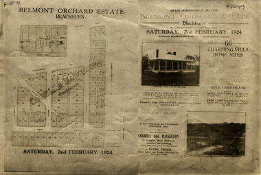
Document, Belmont Orchard Estate, 1924
Brochure for auction of Belmont Orchard Estate, BlackburnBrochure for auction of Belmont Orchard Estate, Blackburn, (now Nunawading) 66 sites, 2 February 1924. Agents: Coghill & Haughton, Frank Fisher.Brochure for auction of Belmont Orchard Estate, Blackburnauctions, belmont orchard estate, patterson street, nunawading, central road, joyce street, lilian street, west avenue -
![Brochure for auction of Eastdawn Estate, Mitcham, 70 lots [20 February 1915]](/media/collectors/56f368632162f118acbff12e/items/60d923316e5f99545134e472/item-media/60d9477c6e5f995451350fb8/item-fit-380x285.jpg) Whitehorse Historical Society Inc.
Whitehorse Historical Society Inc.Document, Eastdawn Estate, 1915
Brochure for auction of Eastdawn Estate, Mitcham, 70 lots [20 February 1915]Brochure for auction of Eastdawn Estate, Mitcham, 70 lots [20 February 1915]. Agents Coghill & Haughton.Brochure for auction of Eastdawn Estate, Mitcham, 70 lots [20 February 1915]auctions, eastdawn estate, mother foster's estate, mitcham road, mitcham, orient avenue, hull parade, vernal avenue -
 Whitehorse Historical Society Inc.
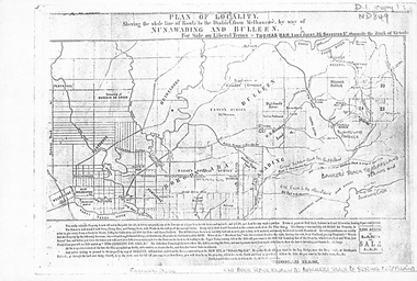
Map, Plan of locality, 1855-60?
'Plan of locality, showing the whole line of route to the district from Melbourne by way of Nunawading and Bulleen. 2,000 acres for sale... Thomas Ham, Land Agent [ 1855 - 60?]nunawading, bulleen, barkers track, land sales -
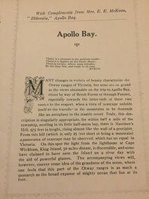 Apollo Bay Museum
Audio - Elderslie Guesthouse tourism booklet
Reading of tourism booklet for the Heart Maps projectapollo bay, elderslie guesthouse, tourism, great ocean rd -
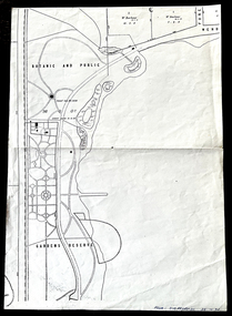 Friends of Ballarat Botanical Gardens History Group
Work on paper - 1885 Map, Ballarat Botanic and Public Gardens Reserve, 1885
Botanic and Public Gardens Reserve: Early Map.This Plan shows how the Ballarat Botanic Gardens had been set out and part of the Lake Wendouree area in 1885.One large cream sheet of paper, folded in two.bottom of the page on the right in blue biro, "From: Jim Reynolds, 29.10.94".john garner collection, garner, dr, map, early, gardens reserve, ballarat botanical gardens, ballarat, gardens, 1885, public, wendouree parade, w. barbour. -
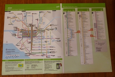 Melbourne Tram Museum
Poster, Yarra Trams, "Melbourne Tram Network" and "Routes from this Stop", Dec. 2012
... Maps ...Full colour poster printed on a vinyl plasticized based sheet, titled "Melbourne Tram Network" - showing a diagrammatic layout of Melbourne tram routes, Myki ticket notes and where tickets can be obtained, information numbers (PTV, phone applications) and information on Tram Tracker, twitter and other contact systems on the left side. On the right side titled "Routes from this Stop" is the information and detailed plan of every stop on routes 3, 3a, 16 and 96, including buses and train stop and connecting tram services. Printed for Stop 136, The Esplanade. Map shown as effective April 2011, printed December 2012. Has the document information on the right hand side of the poster. Two copies held.trams, tramways, yarra trams, ptv, maps, tramtracker, myki, the esplanade, route 96, route 3, route 16 -
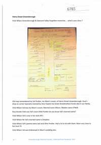 Greensborough Historical Society
Article and Photograph, Henry Street Greensborough, 2017_
Map and information about Henry Street Greensborough, map drawn in 1999 by Valma Simpkins (nee Poulter) of residents and businesses in Henry Street near Grimshaw Street in the 1930s. Further discussion about Poulter and Clayton family connectionsThis photograph and text was copied from a Facebook site. Members are people who lived in the Greensborough area and share their reminiscences of the area with others. The site is administered by a GHS member but is not officially affiliated with the Society. Any information is the opinion of the contributor. Article and photograph sourced from social media.henry street greensborough, valma poulter, valma simpkins, clayton family -
Moorabbin Air Museum
Map - RAAF Navigational Maps
Historical Details: . Description: Official Wartime Maps NewGuinea, New Britain etc AAP Date: 1940-45 Author: RAAF Amended to AL Publisher: RAAF Pages: 15 Maps Binding: Content/Keywords. Level of Importance: -
 Federation University Historical Collection
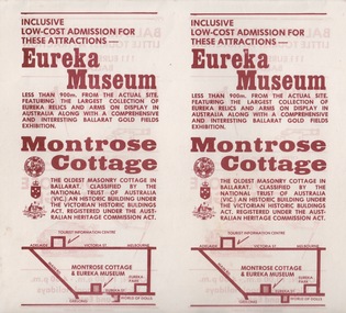
Document - Document - Advertising Cards, ZILLES COLLECTION: Advertising Card for Historic Montrose Cottage and Eureka Museum
Zilles Printers was begun by Lewis Zilles in the early 1930s. It was in McKenzie Street Ballarat. His son Jeffrey also became a printer - letterpress, offset and screen printer. The business became Zilles Printers/Graphics and was in Armstrong Street and later Bell Street Ballarat. Montrose Cottage was build c1856 by John Alexander, builder. He was a Scottish stone mason. It was built with bluestone and hand-made bricks. It is on the Historic Buildings Register, National Trust (Victoria). It is important as a substantial and very early stone cottage. The house is now open to the public. It also provides short term accommodation - self contained apartments. Double sided cards advertising Montrose Cottage and Eureka Museum. Printed by Zilles Graphic Industries, Ballarat. White card with russet colour print. Printed on both sides. Each side has Eureka Museum and Montrose CottageEureka Flag and Cannon. Drawing of Montrose Cottage and flag with Lion. Symbol of National Trust Australia. Coat of Arms. Location map.zilles graphic industries, montrose cottage, eureka musuem -
 Ballarat Heritage Services
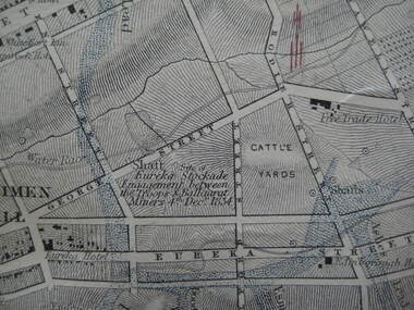
Photograph - Digital photograph, Map Detail Showing the Eureka Stockade site, 1861
Eureka Stockade is the site of the battle between government forces and miners and occurred on 3 December 1854 early one Sunday morning. Around 30 were killed, 130 arrested and 13 tried for High Treason. Many were injured in the affray. digital photographEureka Stockade Engagement between the troops and Ballarat Miners 4th December 1854. * Please note the date is recorded wrongly on the map.eureka site, map, george street, cattle yards, eureka street, ballarat, eureka stockade -
 Montmorency/Eltham RSL Sub Branch
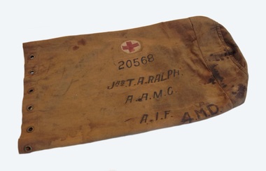
Kit Bag, WW1, World War one era
The kit bag was used by James Thomas Alfred Ralph, who was born in South Australia on 25 September 1897. He enlisted for service in the First World War on 17 May 1918 in Adelaide with the Australian Medical Corps General Reinforcements. He was allocated the service number 20568 and embarked from Adelaide on the HMT Gaika on 6 August 1918. He arrived in London, England on the 13 October 1918 and allocated to the Australian Army Medical Corps Training Depot. He transferred as a medical officer to the 1st Australian Hospital (Hayfield?) on 2 December 1918, and was attached to the 1st Australian Army Hospital (Sutton Vale?) in January 1919. He returned to Australia in Febuary 1920 on the Cape Verde as nursing staff. He was discharged from service in Adelaide on 17th March 1920.Tan coloured canvas kit bag used by a member of the Australian Army Medical Corps during World War 1. The tubular kit bag has 12 brass eyelets placed around its opening, and is reinforced with a second layer of canvas at its base. The kit bag has a side stitched seam, stiching around the base and top opening. A circular lightweight tan canvas flap is stitched to the top opening at the side seam.On the side if the kit bag is a red cross on a white background, surrounded by a circular yellow line. It also has the numbers 20568, with the words JAS.T. A. RALPH, A.A.M.C, A.I.F., AND 4.M.D. The base of the kit bag has a map of Australia in black ink, with 4.M.D printed in black ink above the map. "Sth. Aus." and numbers "20568" are printed in black ink over the map of Australia. The marking 'broad arrow' is printed in black ink on the inside of the top opening.world war one, kit bag -
Bendigo Historical Society Inc.
Map - CAMPBELL COLLECTION: BENDIGO AND DISTRICT MAPS
Map. Eppalock, Sedgwick and Strathfieldsaye, scale 20 chains to 1 inch. Road to Bendigo 13 1/2 miles at top right of map, Longlea Railway Station 5 1/2 miles, Bendigo 11 miles, Strathfieldsaye 5 miles on left of map. Total area 3972 acres. Prepared in W.P.B. from Assessment Plan and Parish Plans. H.A. Darby 14-6-29.H.A.Darbymap, bendigo, agricultural lands -
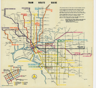
 Melbourne Tram Museum
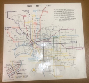
Map, Melbourne & Metropolitan Tramways Board (MMTB), "Tram Route Guide", Aug. 1979
Full colour map or poster printed on clear plastic with an adhesive peel off backing sheets, titled "Tram Route Guide". Map dated 8/79, showing proposed extension to Bundoora, routes with route numbers and names of main destinations. Has notes about the services, weekend and telephone numbers for information. 1979 2 copies held. See Reg Item 1098 for a smaller version of this map.trams, tramways, mmtb, map, routes, posters -
 Melbourne Tram Museum
Map, Melbourne & Metropolitan Tramways Board (MMTB), "Tram Route Guide", Jun. 1979
Full colour map or poster printed on clear plastic with an adhesive peel off backing sheets, titled "Tram Route Guide". Map dated 6/79, showing proposed extension to Bundoora, routes with route numbers and names of main destinations. Has notes about the services, weekend and telephone numbers for information. 1979 Two copies held. See Reg Item 3765 for a larger version of this map.trams, tramways, mmtb, map, routes, posters -
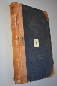 Warrnambool and District Historical Society Inc.
Ledger, Letter book 1892-1904, 1892
This letter book has letters, sketch maps and plans and dates from 1892 to 1904. It came from the office of John William Crawley, Junior, an engineer, architect and surveyor in private practice in Warrnambool and also the engineer of the Shire of Warrnambool from 1895 to 1935. His father, brother and son were also engineers and worked in that capacity or as the Shire Secretary for the Shire of Warrnambool, with the Crawley family recording a total of 132 years of service to the Shire. This letter book was passed on to John Crawley’s son, Rolf Crawley, Engineer for the Shire of Warrnambool from 1935 to 1968. The letter book then came into the possession of Michael Hand who took over the private surveying business of Rolf Crawley in Warrnambool. The Warrnambool and District Historical Society has acquired the letter book, one of several Crawley ledgers, from the Michael Hand estate. This letter book is of considerable significance as it contains maps, plans, sketches and written information which is the work of John William Crawley Junior, the engineer for the Shire of Warrnambool for 40 years. It will be very useful to researchers. This is a hard cover letter book of 500 pages. The cover is black with leather binding on the edges of the cover and on the spine. The pages contain an alphabetical listing of the letters, handwritten letters and many sketch maps and plans. There are several loose pages of plans and diagrams at the back of the book. The inside of the covers has a blue mottled pattern. The edges of the cover are torn. There is a mauve stamp on the first page. ‘Letter Book 1892 to 1901’ ‘Rolf L. Crawley, Civil Engineer, Drainage and Water Supply Engineer, Licensed Surveyor, Registered Architect, Warrnambool’ john william crawley, junior, warrnambool, rolf crawley, warrnambool, shire of warrnambool -
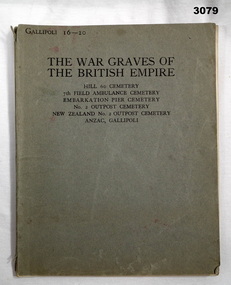 Bendigo Military Museum
Book - BOOK, WAR GRAVES, Imperial War Graves Commission, The War Graves of the British Empire, Post WW1
Grey cardboard cover with black print on front, 52 white pages with black print. Coloured map of Anzac area inside front cover showing maps of cemeteries with names & plot locations of those buried who fell in the Great War.Inside back cover: “Printed by H M Stationery Office Press - Harrow”books military, memorials - tombstones, war graves -
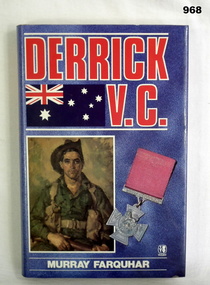 Bendigo Military Museum
Book, Derrick V.C
Authors history on back of dust cover. Book part of N. DALEY Collection. Hard cover, pink colour, title and author in white lettering on spine. Mediterranean Ops map inside front cover. Derrick bike trip to Berri map inside with Australian flag. Printing of soldier and medal on front. Illustrated - 205 pages.N. DALEY Bendigo 1985 inside front cover.books, biography, military history -
Bendigo Historical Society Inc.
Map - CAMPBELL COLLECTION: BENDIGO AND DISTRICT MAPS, 11-4-29
Map. Huntly, Parishes of Huntly Nerring and Neilborough. Scale 20 chains to 1 inch. Total area 4738 acres. Eaglehawk. Prepared in W.J.B. from A. and C.L. Plans by W.J.Galbraith 11-4-29. (number 396 in map cupboard 1)W.J.Galbraithmap, bendigo, agricultural lands -
Bendigo Historical Society Inc.
Map - CAMPBELL COLLECTION: BENDIGO AND DISTRICT MAPS, 14-6-29
Map. Terricks, Parish of Terrick Terrick West, scale 20 chains to 1 inch, total area 6318 acres, prepared in W.P.B. from Assessment and Parish Plans by W.J.G. 14-6-29. (number 388 in map cupboard 1)W.J.Galbraithmap, bendigo, agricultural lands -
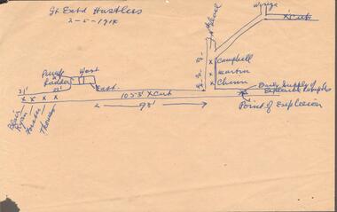 Bendigo Historical Society Inc.
Document - GREAT EXTENDED HUSTLERS MINE - MAP WHERE EXPLOSION OCCURRED
Hand drawn map on beige paper where an explosion occurred in the mine killing seven men. They were Blair, Ryan, Forster, Thomas, Campbell, Martin and Chinn. Map shows where the men were, how far from the point of explosion.mine, gold, great extended hustlers., great extended hustlers mine, map where explosion occurred, blair, ryan, forster, thomas, campbell, martin, chinn -
Bendigo Historical Society Inc.
Map - SALISBURY : COUNTY OF BENDIGO, 1965
Map. Salisbury, County of Bendigo, Pompapiel, Yallook, Yarraberb, Yarrayne, Bullock Creek. Drawn and reproduced at the Department of Lands and Survey, Melbourne. Price $1.00. 1965. By authority A.C. Brooks, Government Printer, Melbourne. (number 28 in map cupboard 1)A.C. Brooks,Government Printer, Melbourne.map, bendigo, salisbury -
Bendigo Historical Society Inc.
Map - CAMPBELL COLLECTION: BENDIGO AND DISTRICT MAPS, 10-5-29
Map. Mandurang, Scale 20 chains to an inch. Total area 5746 acres. Kennington, Township of Mandurang. To accompany my report of 10-5-29 R. Marshall, Forest assessor. Drawn by I.M.K. (number 399 in map cupboard 1)I.M.K.map, bendigo, allotments