Showing 4549 items matching "historical maps"
-
 Victorian Railway History Library
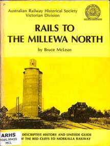
Book, McLean, Bruce, Rails To The Millewa North, 1975
A history of the Victorian Railway's railway from Red Cliffs to Morkalla in far North West Victoria and a lineside guide for the occasion of the 'Back to Millewa' celebrations on 14 & 15 June 1975.ill, maps, p.60.non-fictionA history of the Victorian Railway's railway from Red Cliffs to Morkalla in far North West Victoria and a lineside guide for the occasion of the 'Back to Millewa' celebrations on 14 & 15 June 1975.railroad construction - victoria - history, railroads -- victoria -- history -
 Broadmeadows Historical Society & Museum
Map - Map of Australia, John Bartholomew & Son Ltd, Contour- coloured world map series: Australia, c. 1955
... for research purposes Australia Map Historical information Education ...Printed 1955Quality Map in good condition, can be used for research purposesMap of Australia - Colour contoured - printed on cloth, scale 1:5,000,000australia, map, historical information, education -
 Linton and District Historical Society Inc
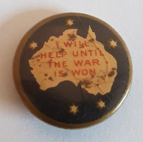
Badge, I Will Help Until the War is Won, 1914-1918
Badge was worn by civilians during World War I, 1914-1918.Black and gold circular badge with map of Australian continent (no Tasmania), surrounded by stars of the Southern Cross. Badge was worn by civilians during World War I, 1914-1918.Text: ' I WILL / HELP UNTIL / THE WAR / IS WON. 'world war i -
 Victorian Railway History Library
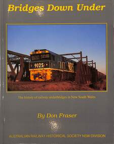
Book, Fraser, Don, Bridges Down Under: The history of Railway underbridges in New South Wales, 2016
A history of railway underbridges (structures that support a railway line) in New South Walesindex, ill, maps, p.202.A history of railway underbridges (structures that support a railway line) in New South Walesrailway construction - new south wales - history, bridges -- new south wales -- design and construction -
 Victorian Railway History Library
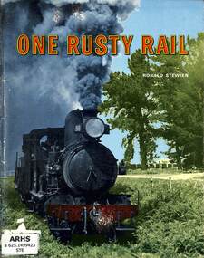
Book, Stewien, Ronald, One Rusty Rail, 1973
A history of the narrow gauge 3'6" and broad gauge 5'3" railways in South-East South Australia centered on Naracoorte and Mt Gambier.ill, maps, p.65.A history of the narrow gauge 3'6" and broad gauge 5'3" railways in South-East South Australia centered on Naracoorte and Mt Gambier.railway construction - australia, narrow gauge railroads - south australia - history -
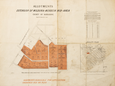 Merbein District Historical Society
Map - Allotments Extension of Mildura-Merbein Mid-Area, Allotments available, 23 November 1920
Allotments available to Discharged Soldiers Discharged Soldier's Settlement Act Historic Large map, folded in 4, coloured map of Merbein indicating allotments available and locality plan. Scale 10 chain to 1 inchPhoto-Lithographed at Department of lands Survey, Melbourne J. Butson 23.11.20discharged soldiers, ww1, soldier settlement, irrigation -
Merbein District Historical Society
Map, Merbein Irrigation District Drainage Systems, 5 Dec.1936
drainage, irrigation -
Merbein District Historical Society
Document, Merbein Cemetery Location map, unknown
merbein township, cemetery -
Merbein District Historical Society
Map, Township of Yelta, 30 Aug.1968
yelta -
Merbein District Historical Society
Map, Township of Yelta (Cowanna), 1958
yelta -
Merbein District Historical Society
Map, Township of Yelta, Jul.1968
yelta -
Merbein District Historical Society
Map, Township of Yelta, Jul.1968
yelta -
Merbein District Historical Society
Map, Township of Yelta (Cowanna), 1958
yelta -
Merbein District Historical Society
Map, Township of Yelta, 30 Aug.1968
yelta -
Merbein District Historical Society
Map, Road Construction Authority Shire of Mildura, Aug.1986
merbein, roads, shire of mildura -
Merbein District Historical Society
Map, State Rivers & Water Supply Commission-Merbein Urban District n.d, unknown
state rivers and water supply commission, merbein township -
Merbein District Historical Society
Map, Mildura and District Map, After 1954
merbein, yelta, merbein south, the lake, merbein west, birdwoodton -
Merbein District Historical Society
Map, Horticultural Blocks - Merbein, c.1920's
blocks, merbein west blocks, merbein blocks -
Merbein District Historical Society
Map, Merbein Drainage Proposed Layout Plan No 65-D-1 (3 parts), unknown
drainage proposed layout plan no 65-d-1 -
Merbein District Historical Society
Map, White Cliffs Homestead Allotments and Farm Allotments, 15 Apr.1909
farm allotments, homestead allotments, parish of yelta, parish of merbein, irrigation, blocks -
Merbein District Historical Society
Map, White Cliffs Irrigation Settlement - Plan of Homestead Allotments, 1917
blocks, irrigation, parish of merbein, homestead allotments -
Merbein District Historical Society
Map, Whitehead's Map of Victoria with Alphabetical Key, 1869
merbein -
Merbein District Historical Society
Map, White Cliffs Irrigation Settlement - Plan of Homestead Allotments, 1917
homestead allotments, parish of merbein, county of karkarooc, blocks, irrigation settlement -
Merbein District Historical Society
Document, Papers regarding the Stephen Thompson Family, 1909+
conditional purchase lease- homestead allotment, stephen thompson, john coulter thompson, block, local land board - notes of evidence, application for property to local land board, map lot 52 (s. thompson) & lot 51 (j.c. thompson), house, eldora -
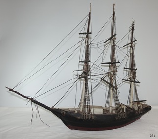 Flagstaff Hill Maritime Museum and Village
Craft - Ship model, Johann A. Landmann, Wilhelmsburg, 1853
This ship model of the Wilhelmsburg was made by Johann Landmann during his journey on the very vessel, the sailing ship Wilhelmsburg. It was donated to Flagstaff Hill by the wife of Landmann's great-grandson. Landmann (or Landman, also known as August Landmann) was born in 1826 in Ganhor, Silesia, Prussia. At the age of 20, he travelled through Europe, working from town to town as a cabinet maker. At 26 years old he returned to Germany, married Anna Rosina in Wahlstatt, Prussia, and on the same day sailed for Australia on the Wilhelmsburg in 1853, the year the ship was registered. The Wilhelmsburg was a three-masted, square-rigged sailing ship built at Reiherstieg, Hamburg, and registered in Hamburg on 27th April 1853. On her maiden voyage in 1853, the ship sailed from Hamburg, Germany, to Australia with 510 passengers on board, including emigrants under the Bounty Scheme. Johan Landmann was one of the passengers. The Wilhelmsburg arrived in Hobson’s Bay, Melbourne after sailing for 100 days. Johann spent a week in Melbourne then travelled to Warrnambool aboard the Merry Kitty, arriving fourteen days later. Johann had landed in Melbourne with only 16 shillings in his pocket and by the time he arrived in Warrnambool, he only had one shilling and sixpence left. He also had very limited ability to speak English. He settled in the Allansford area, near Warrnambool, together with other families from Germany and went on to play a significant role in the history of Warrnambool. Johann worked as a cabinet maker in Warrnambool, making the first coffin in the Warrnambool cemetery. He also worked as a general merchant. He built many of the earliest shops in Warrnambool, and the first paddle boat used on the local Hopkins River. He made models of Warrnambool’s Ozone Hotel and Presbyterian Church; the model of the Hotel is now in the Warrnambool Art Gallery, and the model of the Presbyterian Church has been in the care of the Warrnambool & District Historical Society since around 2017. One of Landmann's residences was a two-storey building in Henna Street Warrnambool where he, lived upstairs and operated his business downstairs. After he retired Landmann built a ‘handsome stone residence’ at 30 Mickle Street, Warrnambool, where he lived until his death in June 1920; he was aged ninety-five. “Landmann Street” in Warrnambool has been named after Johann and appears on a map in 1872. He has also been honoured on Warrnambool’s Pioneer Memorial Board which is displayed at the Warrnambool and District Historical Society. Landmann's son Adolph Fritz Landmann (Fritz Landmann) born in 1861, was a Councillor from 1905 to 1915, and Mayor of Warrnambool from 1912 to 1915. The Wilhelmsburg sailed from Hamburg in 1863 heading for Queensland, Australia, but in December the vessel was wrecked off the coast of Holland during storms, with the loss of 247 lives.The ship model of the Wilhelmsburg is significant historically, having a connection to the maiden voyage of a ship that holds the record for the number of passengers carried in one journey on such a small vessel. It is also significant as it is believed to be the only existing model or representation of the ship. Johann Landmann, the maker of the model, was one of the earliest residents in Warrnambool and is a significant historical figure in colonial Warrnambool. He has the honour of appearing on the Memorial Pioneers’ Board. Landmann used his craftsmanship skills to make several early Warrnambool buildings, the first coffin in the cemetery, the first paddle boat on the Hopkins River as well as models of significant local buildings. Model of the sailing ship Wilhelmsburg, carved in wood by Johann Carl Augustus Landmann in 1853. The three-masted model barque is painted black. It has a long bow spit. flagstaff hill, flagstaff hill maritime museum, maritime museum, warrnambool, barque, wilhelmsburg, landmann, johann landmann, augustus landmann, landman, ozone hotel warrnambool, presbyterian church warrnambool, 30mickle street warrnambool, ship model, shipwreck coast, 1853, fritz landmann, warrnambool councillor, warrnambool mayor, anna rosina, maiden voyage, bounty scheme, hobson's bay, hamburg, merry kitty, coffin maker, cabinet maker, paddle boat, henna street, landmann street, pioneer memorial board -
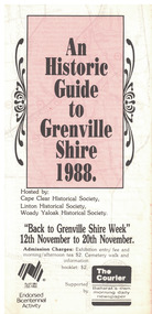 Linton and District Historical Society Inc
Document - Leaflet, An Historic Guide to Grenville Shire, 1988
... Grenville Shire Cape Clear Historical Society Linton ...A4 sized printed leaflet folded into three. White background with pink rectangle on front. Black printed text throughout. Inside of leaflet is a map with places of interest circled and numbered in red ink.Text, front: 'An / Historic / Guide / to / Grenville / Shire / 1988. / Hosted by: / Cape Clear Historical Society, / Linton Historical Society, / Woady Yaloak Historical Society. 'grenville shire, cape clear historical society, linton historical society, woady yaloak historical society, bicentennial celebrations, maps -
Merbein District Historical Society
Map, Plan Of Merbein West - Allotments 137-173, 12 Jul.1908
maps, allotments, merbein west -
Merbein District Historical Society
Map, Birdwoodton (Merbein) Allotments - Sec A, 4 Mar.1938
-
Merbein District Historical Society
Map, Township of Merbein - Sale of Allotments, 29 Jul.1914
-
Merbein District Historical Society
Map, Parish of Merbein - Irrigation Allotments, 3 Aug.1912
irrigation