Showing 41895 items
matching were
-
 Kew Historical Society Inc
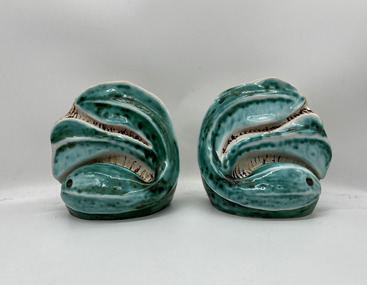
Ceramic - Wall sculptures, Viola Ayling, 1950–1970
Viola Annie McVicars (1911–1990) was born in Korumburra on 29 April 1911. At the age of 21, she married William John Ayling (1909–1995). After their marriage in 1932, they moved to Kew, initially to 81 Tennyson Street, and later to 180 Pakington Street. A professional tailoress, Viola Ayling was also a talented amateur potter, creating her ceramics at her home in Pakington Street, where she had an internal studio and a handmade, wood-fired brick kiln in her backyard. Following her death in 1990, her studio pottery passed to her daughter, and following the daughter’s death, to her granddaughter. This piece of glazed earthenware is part of a collection of 15 functional and decorative ceramic items donated by Viola’s granddaughter to the collection in 2024.A pair of handmade bookends, expertly potted and glazed. The style is representative of Australian ceramic design of the period, particularly that employed by Klytie Pate.Pair of hand moulded abstract ceramic wall sculptures with holes and marks of the original wires on the reverse. The front and back are glazed while the interior has been left unglazed. The free-form shapes resemble waves which were initially covered with a white glaze which was then overgrazed in a semi-transparent turquoise glaze. Both pieces are signed by the artist on the reverse.Signature to bases: "V. Ayling"ceramics, pakington street -- kew (vic.), viola annie mcvicars, viola annie ayling, ceramic sculptures -
 Bendigo Historical Society Inc.
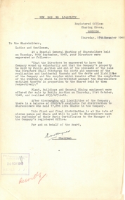
Document - MCCOLL, RANKIN AND STANISTREET COLLECTION: NEW DON NO LIABIITY CORRESPONDENCE
Two documents relating to winding up of the Company. a. Letter to the shareholders, dated Thursday 18th November 1948, stating that at a special general meeting of shareholders that directors were empowered to have 'the Company wound up voluntarily and that the company's property be sold by Public Auction ......' b. Financial statement as at 9/11/'48 for New Don No Liability, total assets £820.4.8.business, mining, new don no liability mine -
 Bendigo Historical Society Inc.
Newspaper - JENNY FOLEY COLLECTION: HISTORY MAKERS
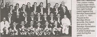
BHS CollectionBendigo Advertiser ''The way we were'' from Monday, December 6, 2004. History makers: the Loddon Valley league team which contested Bendigo's first night football match against the Bendigo Association on June 11, 1951. Played at the Bendigo Showgrounds, the match was won by the Bendigo Association by four points. A white football was used during the game.newspaper, bendigo advertiser, the way we were -
 Bendigo Historical Society Inc.
Newspaper - JENNY FOLEY COLLECTION: FLOATING ALONG
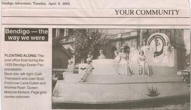
BHS CollectionBendigo Advertiser ''The way we were'' from Tuesday, April 8, 2003. Floating along: the post office float during the 1939 Bendigo Easter Fair procession. Back row: Cath Thompson and Joan Bool. Front row: Lena Cullen and Windfred Ryan. Queen: Marjorie Mollard. Page girls: names unknown. The clip is in a folder.newspaper, bendigo advertiser, the way we were -
 Melbourne Tram Museum
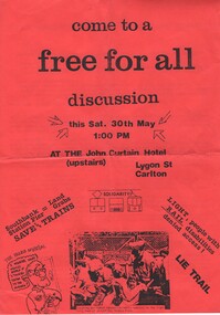
Pamphlet, Public Transport Victoria (PTV), "come to a free for all discussion", May. 1987
Pamphlet - A4 printed on red paper, titled "come to a free for all discussion" , advertising a meeting at the John Curtain Hotel, Lygon St Carlton, 30 May (1987). Makes reference to the Light Rail system and lack of information and threats to existing workers, users, disabled. Produced by the Public Transport Workers Association - who were not happy with the Unions.trams, tramways, unions, personnel, light rail, lrv, south melbourne depot, preston depot -
 Melbourne Tram Museum
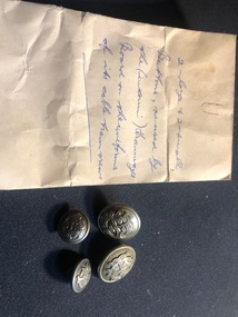
Uniform - Coat Button/s, Buttons Birmingham, c1916
Set of four nickel silver MMTB Coat buttons with brass backs and a sewing lug or ring on the rear. All of the items are made by Buttons of Birmingham - name stamped into the rear section. Two large - 22mm diameter and two 15mm dia. Received in a small envelope with information that they were issued by the Interim Tramway Board. The design appears to be similar or identical to that of the MMTBIn a small manila envelope "2 large and 2 small buttons issued by the (interim) Tramways Board on their uniforms of its cable tram crews"trams, tramways, melbourne tramways, uniforms, buttons, tramway board, cable trams -
 Melbourne Tram Museum
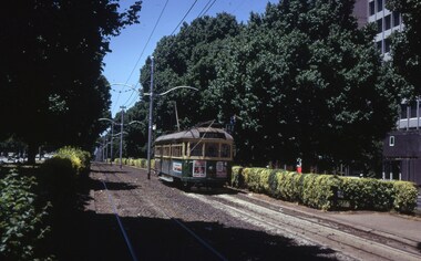
Slide, Peter Moses, 1974
Photograph looking west along Victoria Parade from about Smith St with SW5 843 during 1974. Shows the hedges that were along the track. Tram on a route 42, City service. Tram has advertisements for Courage Draught and Dirty Dicks. Kodak cardboard mount slide, taken by Peter Moses. Slide mount dated Dec. 1974.In ink on slide " 1974 Melbourne Victoria Pade"trams, tramways, victoria parade, sw5 class, route 42, tram 843 -
 Melbourne Tram Museum
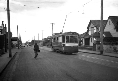
Negative, Wal Jack, 21/04/1945 12:00:00 AM
Black and white negative, by Wal Jack, of S 166 in Barkly St West Footscray, near intersection with Blandford St. returning to Footscray with an X1 at the end of the double track. The two church buildings were still there 9/2020 on Google Earth, but had a temporary fence in front of them. In the Wal Jack Melbourne album, the date is 21-4-1945.trams, tramways, russell st, barkly st, footscray, s class, tram 166, mmtb -
 Melbourne Tram Museum
Negative, Wal Jack, c1940
Black and white negative by Wal Jack of U211, 209 and the Ballast car stored at Preston Workshops. Photo maybe 19-1-1941 or 13-10-40, based on other similar photo dates. The car numbers were detailed in the album held by the Ballarat Tramway Museum. See Reg Item 6370 for a photo by Ray Pearson of these trams at the workshops.trams, tramways, preston workshops, u class, work trams, tram 211, tram 209, tram ballast motor -
 National Vietnam Veterans Museum (NVVM)
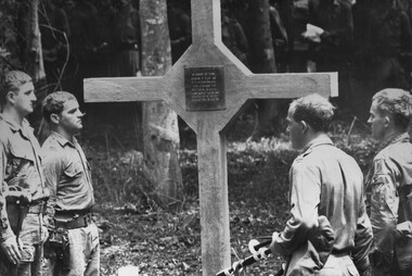
Photograph, Gibbons, Denis, Long Tan Cross Dedication
Denis Gibbons (1937 – 2011) Trained with the Australian Army, before travelling to Vietnam in January 1966, Denis stayed with the 1st Australian Task Force in Nui Dat working as a photographer. For almost five years Gibbons toured with nine Australian infantry battalions, posting compelling war images from within many combat zones before being flown out in late November 1970 after sustaining injuries. The images held within the National Vietnam Veterans Museum make up the Gibbons Collection. A black and white photograph at Long Tan, Phuoc Tuy Province, South Vietnam, 18/08/1969. During the dedication of the Cross the original members of D Company 6 RAR who were present at the battle flanked the cross (L to R) Sgt J Beere, Cpl W "Piggy" O'Rourke, Cpl W.A. Roche and a 6 RAR Piper.photograph, long tan, d coy, 6 rar, sgt j beere, cpl w "piggy' o'rourke, cpl w a roche, gibbons collection catalogue, pipers, phuoc tuy province, long tan cross dedication, 6 rar piper, denis gibbons -
 Bendigo Historical Society Inc.
Magazine - LA TROBE UNIVERSITY BENDIGO COLLECTION: EMBERS 1955
A 1955 copy of a page from 'Embers' the Bendigo Teachers' College magazine. It covers the current news and activities of the college in that year. There is news on a farewell social given to Mr. and Mrs.Colin Archibald who were returning to America after Mr. Archibald taught at the college. A cartoon of the college basket ball team is among the sporting news on campus. See 3320.100bendigo, education, bendigo teachers' college, la trobe university bendigo collection, collection, bendigo, education, embers, bendigo teachers' college, teacher training, magazine, tertiary education, teaching, history, miss. j.c. burnett, mr. geoff pryor -
 National Vietnam Veterans Museum (NVVM)
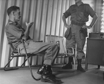
Photograph, Gibbons, Denis, Making A Point
Denis Gibbons (1937 – 2011) Trained with the Australian Army, before travelling to Vietnam in January 1966, Denis stayed with the 1st Australian Task Force in Nui Dat working as a photographer. For almost five years Gibbons toured with nine Australian infantry battalions, posting compelling war images from within many combat zones before being flown out in late November 1970 after sustaining injuries. The images held within the National Vietnam Veterans Museum make up the Gibbons Collection. A black and white photograph of Maj Gen Doug Vincent Commanding Officer, Australian Force Vietnam "forcefully" makes a point to Lt Col Don Begg, Commanding Officer 1st Field Regt RAA. The talks were held in the Ist ATF Commanders office at Nui Dat, Phuoc Tuy Province, South Vietnam (circa Feb 1967)photograph, maj gen doug vincent, lt col don begg, 1st field regt, 1st atf base, nui dat, phuoc tuy province, gibbons collection catalogue, australian force vietnam, 1st field raa, australian task force, denis gibbons -
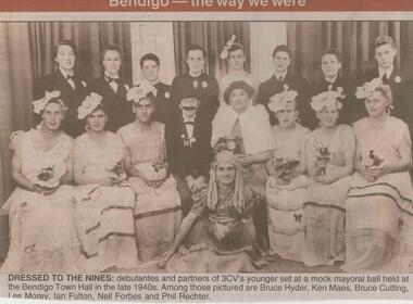 Bendigo Historical Society Inc.
Newspaper - JENNY FOLEY COLLECTION: DRESSED TO THE NINES
BHS CollectionBendigo Advertiser ''The way we were'' from 2002. Dressed to the nines: debutantes and partners of 3CV's younger set at a mock mayoral ball held at the Bendigo Town Hall in the late 1940s. Among those pictured are Bruce Hyder, Ken Maes, Bruce Cutting, Les Morey, Ian Fulton, Neil Forbes and Phil Rechter. The clip is in a folder.newspaper, bendigo advertiser, the way we were -
 Port Melbourne Historical & Preservation Society
Photograph - Various ships at Station Pier, Port Melbourne, The Age, 4 Jan 1968
COPYRIGHT THE AGE Two black and white photographs each showing 2 ships at Station Pier . .01 - "Iberia" (inner East) and "Guglielmo Marconi" (outer East) .02 - "Achille Lauro" (inner West) and "Orcades (outer West). Cars line both sides of Station Pier. All four ships were in at the Pier at one time. 04.01.1968transport - shipping, piers and wharves - station pier, ss iberia, ss guglielmo marconi, ss orcades, ms achille lauro -
University of Melbourne, Burnley Campus Archives
Album - Colour 35mm slides, Kodachrome, Excursion to Canberra, 1990
(1) 48 colour slides of views of Canberra including the National Botanic Gardens, Mt Ainslie, Black Mountain and Mt Kosciusko. Most labelled. (2) The Australian Garden Journal Vol 9 No 4 August/September 1990. Contains several articles on Canberra. Probably from a student excursion to Canberra as they were found in the former Staff Room. Not scanned.canberra, national botanic gardens, mt ainslie, black mountain, mt kosciusko, the australian garden journal, excursion -
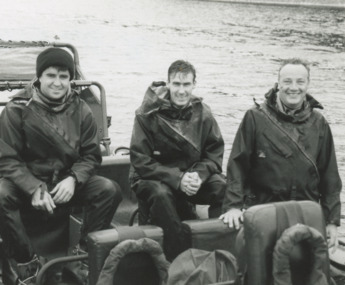 Lakes Entrance Historical Society
Photograph, Lakes Post Newspaper, Australian Army at Lakes Entrance Victoria, 1/03/1996 12:00:00 AM
Black and white photograph of Cpl Amir Tito Mick Allen and Giz McKechnie of Australian Army training in a Rigid Inflatable boat on Cunninghame Arm Lakes Entrance Victoria. Also a black and white photograph taken at the same time at New Works Jetty another R I B shown in distance Nine members were involved in training military history, people, r a a f, world war 1939 - 1945 -
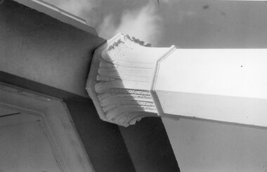 Stawell Historical Society Inc
Photograph, Pioneers’ Memorial on Big Hill -- 2 Photos
Two black & white photographs of the Pioneers’ Memorial. One photo shows a close-up view of Corinthian Pillar supporting the roof of the dome. The other photo is a distant view of the memorial with a view of the directional pedestal under the dome installed in c 1947. Note the white iron posts either side of the steps to protect the memorial from external hazards.Two black and white photos of Pioneers Memorial on Big Hill Stawell. One photo shows the detail view of the top of the Corinthian pillar. The second photo is a view of the memorial showing the directional indicator pedestal installed in c 1947. The white iron posts either side of the steps on the second photo were constructed to protect the memorial from hazards such as cars.stawell -
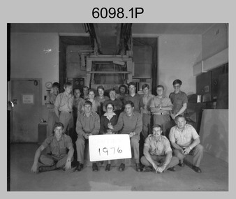 Bendigo Military Museum
photograph - Camera Section, Lithographic Squadron at the Army Survey Regiment, Bendigo, 1976, 1978 and 1979
This is a set of four photograph of Camera Section, Lithographic Squadron, one of the Army Survey Regiment’s four squadrons, at Fortuna, Bendigo in 1976, 1978 and 1979. The main tasks undertaken by Camera Section’s technicians were photographic enlargements, reductions and duplication of map reproduction material, and processing of aerial photography. Photo .2P and its enlargement (.3P) was taken with Camera Section in front of the Klimsch Commodore camera on the 5th of October 1978, before its decommissioning. It was replaced with a new Klimsch model with computerised control, improved speed and consistent controlled output.This is a set of four photograph of Camera Section, Lithographic Squadron, Army Survey Regiment at Fortuna, Bendigo, c1970s. The black and white photographs were printed on photographic paper and are part of the Army Survey Regiment’s Collection. The photographs were scanned at 300 dpi. .1) - Photo, black & white, 1976, Back Row L to R: unidentified, Garry Hudson, unidentified, Greg Kidman, unidentified, Bob Chamberlain, Mick ‘Buddha’ Ellis, Zoe (Lisiewich) Ames, Bill Jones, Trevor Osborne, Dave Miles, Chris Osborne. Front Row L to R: Frank Lenane, Gavin Neilson, Joanne Green, Warren ‘Waldo’ Shirley, Peter Coombes, John Nicholls. .2) & .3) - Photo, black & white, 5th Oct 1978, Back Row L to R: CPL Bob Chamberlain, Greg Kidman, SSGT George Graham, Chris Osborne, John Nicholls, Frank Lenane, Terry Edwards, Bill Jones, CAPT Gary Kenney, Peter Imeson. Front Row L to R: CPL Warren ‘Waldo’ Shirley, SPR Mick ‘Buddha’ Ellis, CPL Garran Hill. .4) - Photo, black & white, 1979, Back Row L to R: WO2 George Graham, CAPT Stan Vote, Peter Imeson, Gary Tremain, Penny Knott, Zoe (Lisiewich) Ames, Di Chalmers, Rob Bogumil, Bill Jones, Rhys De Laine, Brian Fauth, John McCracken. Front Row L to R: SGT Ralph Chant, SGT Garran Hill, CPL Gavin Neilson, Frank Lenane, Paul Baker, SSGT Trevor Osborne.No personnel are identified. Each photo is annotated on the front. .1P annotated ‘1976’ .2P &.3P annotated ‘CAMERA SECT 5 Oct 1978 The Last of the old Klimsch’ .3P annotated ‘Camera ‘79’royal australian survey corps, rasvy, army survey regiment, army svy regt, fortuna, asr, litho -
City of Moorabbin Historical Society (Operating the Box Cottage Museum)
Newsletter - CMHS April 2014 pdf, April 2014
The City of Moorabbin Historical Society was formed c 1960 by a group of Moorabbin area residents who were concerned that the history of the area should be preserved. A good response to a call for items related to the historical area of Moorabbin Shire brought donations of a wide variety of artefacts that are now preserved by the current members of CMHS at Box Cottage Museum. Helen Stanley, Secretary of CMHS, began producing a Newsletter for members in April 2007 to provide current information and well researched items of historical interest. Jim Dale continued to produce the Newsletter in 2013 after Helen resigned. 3 x A4 paper pages printed on one side with colour photographs, Jim Dale, President, welcomes members to the April 27th Meeting at Box Cottage. There were many visitors on the February Open Day including Jeff Marriot. In March some guests from a Wedding at the Rotunda in Joyce Park visited. Chris and Judy Hawker, relatives of early aviator Harry Hawker were presented to Her Excellency, the Governor General of Australia, Quentin Bryce during the Centenary of Military Aviation Air Show, held at Point Cook on March1st & 2nd. Jim representing CMHS attended this memorable occasion. Jim also attended Moorabbin Primary School March 3rd where he told the pupils about Harry Hawker. March 22nd Jim, Valma and Anne attended the Moorabbin Primary School Fete handing out leaflets and talking about Box Cottage Museum. City of Glen Eira is conducting a project for WW1 Centenary involving significant Street names in the area eg Monash, Chauvel, Birdwood etc. Jim has compiled a story about Thomas Calcutt 1809 - 45, a shepherd who emigrated from Oxford, England to Brighton Victoria 1842. He was part of the Henry Dendy 's assignment of settlers. Thomas obtained employment with Public Works and lived in Brighton with his family. Sadly he died during the 6km walk home from his work in St Kilda to Brighton 1845. After a 2 day search his body was found. He was the first immigrant to die in this area and subject to an Inquest.City of Moorabbin Historical Society Newsletter APRIL 2014city of moorabbin historical society, stanley helen, dale jim, melbourne, moorabbin, brighton, cheltenham, ormond, bentleigh, market gardeners, pioneers, early settlers, east bentleigh, city of kingston, marriott jeff, hawker harry, aviators, moorabbin primary school, peulich paul, point cook airforce base, bryce dame quentin, hawker judy, hawker christopher, city of glen eira, world war 1 1914-18, monash sir john, calcutt thomas, calcutt eleanor, calcutt george, calcutt rosanna, calcutt henry, dendy henry, henry dendy's special survey 1841, wilmot w b md jp, st andrew's church of england brighton victoria -
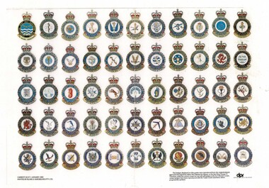 Lara RSL Sub Branch
Squadron Insignia / Badges of the Royal Australian Air Force, Badges of the Royal Australian Air Force, Current as at 01January 1983
2 x Laminated colour photocopy of poster of RAAF Squadron Insignia / BadgesThe badges displayed on this poster were produced from the original artwork approved and signed by either Her Majesty the Queen, or the late King George VI. Therefore, while the correct crown for use with all badges is the St. Edward's crown, certain badges have been reproduced with the Tudor crown and these will be progressively updated. Defence Public Relationsraaf badges, squadron badges, badges of the raaf -
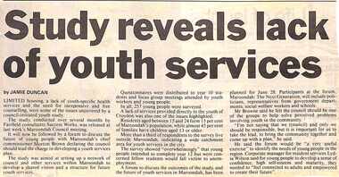 Ringwood and District Historical Society
Newspaper, Scrapbook Clipping, Library Collection, Ringwood, Victoria, `
``Newspaper clipping from "The Mail", 21-5-96 P3. Study reveals lack of youth services. By JAMIE DUNCAN Limited housing, a lack of youth-specific health services and the need for inexpensive and free counselling, were some of the issues uncovered by a council-initiated youth study. It will now be follwed by a forum to discuss the future of young people with Maroondah's chief commissioner Moreton Brown declaring the council should lead the charge in developinfg a youth services plan.` -
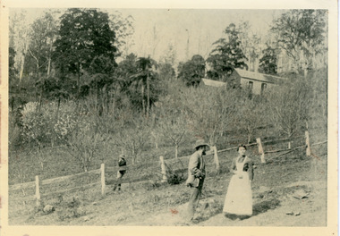 Mt Dandenong & District Historical Society Inc.
Photograph, George Dodd With Daughter Jessie 1890, 1890
1890 picture of George Dodd and his daughter Jessie (Mrs Ebbels) with the Dodd home in the background. The descriptive text on the reverse of this photograph was hand written by John Lundy-Clarke.1890 picture of George Dodd with his daughter Jessie (Mrs Ebbels) with the Dodd home in the background. Remains of the house were burned in the bushfires between 1910 and 1926 when Alan grandson of George and his wife Vera, nee Devine, started to build their home on the same spot and developed the present extensive flower farm “Rainbow Gully”.george dodd, jessie dodd, jessie ebbels -
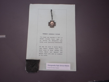 Wangaratta High School
WHS Sports Medal, 1917
Small silver medal with a protruding laurel wreath and shield awarded to H. Taylor in 1917 for winning the junior swimming championships. It has a leather protective pouch and a explanatory notice reading:HERBERT LONSDALE TAYLOR This medal was awarded in 1917 to Herbert Lonsdale Taylor, aged 13, for winning the Wangaratta High School Junior Swimming Championship. He was the uncle of Carole Martin (nee Taylor), Graeme Taylor, and great uncle of Kylie, Bradley and Travis martin and Malcolm and Narelle Taylor who were all students at this school. -
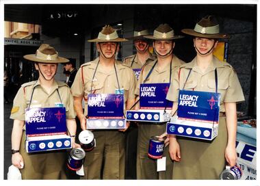 Melbourne Legacy
Photograph, Legacy Appeal 1999, 1999
Two groups of badge sellers outside Legacy House for Badge Week in September. The students from Ivanhoe Grammar helped sell badges and members of the Australian Defence Forces. The photo of the school boys featured in a newsletter in October 1999.A record of fundraising for Badge Week.Colour photo x 2 of badge sellers outside Legacy House.00509.1 has P3 in pencil plus printing on the back "legacy appeal, fundraising, badge week, army, adf -
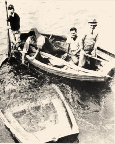 Queenscliffe Maritime Museum
Photograph - Black & white photograph of dinghies, Rescue dinghies, unknown
Couta fishing boatsCouta fishing boat RFD399B & W photo of the sunken rescue dinghyReverse - " L to R / Frank Ferrier, Ron Shapter, Tony Jergens, Tom Warren / sunken 14 ft dinghy used in rescue of wreck of Merlan / This sat on Lonsdale pier for a considerable time (2 years?) prior to rescue. When they put it in to rescue the dinghy commenced filling and rescue were carried out while bailing. ".historical references -
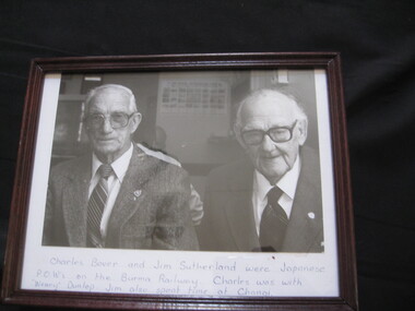 Lilydale RSL Sub Branch
Photograph - Photo of RSL service Members
Charles Bover and Jim Sutherland were Japanese POWs on the Burma Railway. Charles was with Weary Dunlop. Jim also spent time at Changi. Lilydale RSL members Bover C Vx8270 2/2nd Pioneer Btn - Thai-Burma Railway Sutherland JJ Vx54057 2/2nd Pioneer Btn - Thai-Burma Railway and Changipow, changi, thai/burma railway -
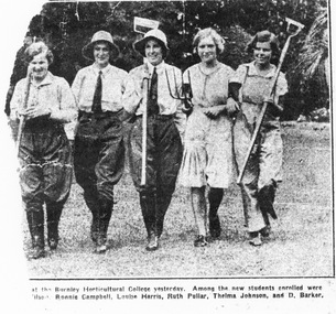 University of Melbourne, Burnley Campus Archives
Photograph - Black and white photocopy, Dorothy Baker, New Students at Burnley Horticultural College, 1931-1932
The original newspaper cutting was lent by Dorothy Baker Barker (1933) in 1991 and returned in February 1992.Photocopy of a newspaper article with a photograph of 5 female students in a line carrying tools.The inscription reads, "... at the Burnley Horticultural College yesterday. Among the new students enrolled were G. Wilson, Ronnie Campbell, Louise Harris, Ruth Pullar, Thelma Johnson and D. Barker." 5 female students walking along side by side, four of them are carrying gardening implements, three in jodhpurs, one in overalls and one in a dress.female students, burnley horticultural college, g. wilson, louise harris, ruth pullar, thelma johnson, dorothy baker ( barker), ronnie campbell -
 Glenelg Shire Council Cultural Collection
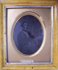
Negative, Mr. John Pearson, c. 1890
Tinted portrait of a seated man. He is turned to the right, and has his left hand resting on a table, loosely holding a pair of folding spectacles (tinted gold). He is wearing a three-piece suit, black cravat with a small knot, checked trousers and has curly hair and long side burns.Front: (no inscriptions) Back: Mr. John Pearson, Percy Street, Portland (black fountain pen, centre). This photo came from Windsor Cottage. John pearson and Captain Fawthrop were great friends. They are buried together in the Queensland Cemetry (black ink, lower centre). Harry Ward Goldsmith, late of Portland (pencil, lower centre).ambrotype, photography, james fawthrop, admella, portrait photography -
 Wangaratta RSL Sub Branch
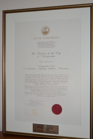
Document - Framed Document, Freedom of the City of Wangaratta, 27/10/1990
The 2/24th Australian Infantry Battalion Association was uniquely granted the Freedom of the City by the Rural City of Wangaratta in 1990 - to our knowledge the only/first Battalion Association in Australia to be granted this honour. Council acknowledges its appreciation of the contribution made by this Unit to community peace and national democracy and congratulates “Wangaratta’s Own” 2/24 Australian Infantry Battalion Association on its Fiftieth Anniversary since formation.The 2/24th Australian Infantry Battalion Association was uniquely granted the Freedom of the City by the Rural City of Wangaratta in 1990 - to our knowledge the only/first Battalion Association in Australia to be granted this honour. Council acknowledges its appreciation of the contribution made by this Unit to community peace and national democracy and congratulates “Wangaratta’s Own” 2/24 Australian Infantry Battalion Association on its Fiftieth Anniversary since formation.Brown timber and gold gilt edged frame containing document with three signatures and red seal. A plaque is attached to glass on lower edge below document.Plaque reads - On 18 November 1994 the City of Wangaratta the Shires of Wangaratta, Oxley and part of the Shires of Benalla, Yarrawonga and Beechworth were amalgamated to create what is now the Rural City of Wangaratta. On 9 November 1996 the Commissioners and Citizens Proudly conferred "Freedom of Entry to the Rural City of Wangaratta" on the 2/24th Infantry Battalion Association.freedom of the city of wangaratta, 2/24th australian infantry battalion association -
 Kiewa Valley Historical Society
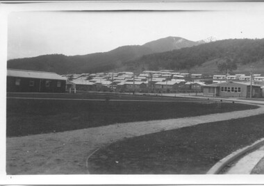
Photographs - Townships of Mt Beauty and Bogong and the Kiewa Valley, c 1940, 1950, 1960
The township of Mt. Beauty was built to provide family accommodation for personnel working on the construction of the Kiewa Scheme. construction commenced in 1946. Photo 1 is looking towards the corner of Lakeside Ave. and Kiewa Crescent. The Post Office is on the corner and the original building housing the Co op store was in Kiewa Crescent. Photo 2 is taken at a later date as the garden in front of the Post Office is well established. The Community Centre is centre left of the photo and the back buildings are the staff accommodation called "The Chalet". Photo 3. Farming country taken from Wallacedale. The Wallaces were one of he early farming families in the Kiewa Valley. Photo 4. This photo is of Junction Camp at Bogong Village and was commenced late in 1939 and by 1940 accommodated 96 men who were engaged in work on Junction Dam. Sleeping accommodation was provided in hutments, each of four rooms, each room being approx. 12 feet by 10 feet and provided for the accommodation of 2 men. This camp remained in use until November 1962.These photos have both historical and social significance. They show the type of accommodation available for workers during the construction of the SEC Kiewa Hydro Scheme as well as early streetscape views of Mt. Beauty. The Junction Camp photo also shows the state of the forest following the 1939 fires in the area.4 Black and white photographs of various sizes.Photo 1. On back, hand written in pencil: top left hand corner: "Sept 1950". Centre of photo: "Return to Gibson Envelope". Right hand side: "Cooper". Bottom left corner: "Mt. Beauty Camp SEC Kiewa Scheme". Photo 2. No inscriptions or markings. Photo 3. Back of photo handwritten in pencil: "In W>T> June 14. 1961 page31. Some of the farming country in the Kiewa Valley. This taken from the home of Mr. Geoff Wallace Wallacedale, Kergunyah where some of his 600 cattle were rounded up." Bottom right corner "Return to Gibson Envelope". There is a copyright stamp belonging to "the Herald & Weekly Times Ltd. also on the back. Photo 4. Typed on a sticker on the back of the photo "Stable attendants Cottage and Camp Sept. 1940".camp, sec kiewa scheme, kiewa, cattle, mt. beauty