Showing 10832 items
matching maps
-
 Lakes Entrance Regional Historical Society (operating as Lakes Entrance History Centre & Museum)
Book, Drew G J, Discovering Historic Burra, 1998
A description of the historic copper mining area of Burra, South Australia with maps tourist trail photographs.historic sites, township, mines and mining -
Lakes Entrance Regional Historical Society (operating as Lakes Entrance History Centre & Museum)
Book, Department of Natural Resources and Environment, Request for Tender - Recreation Earthworks in Colquhoun Forest, 2002
Tender request for recreation building works in the Colquhoun Forest, especially bridges. Contains a location maprecreation, government -
Lakes Entrance Regional Historical Society (operating as Lakes Entrance History Centre & Museum)
Book, Department of Natural Resources and Environment, Australian Natural Heritage Charter - Standards, 2002
Tender specifications for recreation earthworks in the Colquhoun Foret, including pathways and drainage. Contains location map.government, recreation -
Stawell Historical Society Inc
Map, T.F. McGauran, William Couty of Borong 1891, 1891
Stawell Water Supply Reserve. Grampians State Forest. Dairy Creek, Fyans Creek, Barney's Creek, Bovine Creek, Glasstree Creek, Stoney Creek. Stawell Water Supply Aquaduct Fkuming Tunnel.A2 Parish Map of Willam Inculdin Stawell Water Supply Reserve and Creeks. Marked in redPhoto Lithographed at the Department of Lands and Survey Melbourne. By T.F. McGauran 20.07.91 water supply survey -
Stawell Historical Society Inc
Map, Department of Mines Victoria, Alluvial Map Stawell Region, 1870's
c1870 Coloured map showing Black Range North to Stawell and Illawarra. Shows geological layout.Department Mines Victoria 1952/G/2 mining, gold, map -
Koorie Heritage Trust
Book, Beauglehole, A. C, The distribution and conservation of vascular plants in the Melbourne area, Victoria, 1983
iii, 156 p. : ill. ; 22 x 30 cm. + 1 folded col. map.indigenous vascular plants. distribution. melbourne region | botany -- victoria -- melbourne region. -
Koorie Heritage Trust
Book, Beauglehole, A. C, The distribution and conservation of vascular plants in the Ballarat area, Victoria, 1983
iv, 94 p. : ill. ; 22 x 30 cm. + 1 folded col. map.indigenous vascular plants. distribution. victoria. ballarat region. | botany -- victoria -- ballarat region. -
Koorie Heritage Trust
Book, Banfield, Lorna. L, Green Pastures and Gold: A history of Ararat, 1974
Early contacts between Thomas Mitchell and Aboriginal peoples and the later violent encounters involving settlers and squatters. The work and contacts of G.A. Robinson among the various peoples of the Western District. Gatherings of many Aboriginal peoples at Lake Bolac for eeling season, during which there was also trading of sandstone, obsidian and other materials for weapons and spears. Photograph of Jenny 'Ware' "the last of the Fiery Creek tribe of the Aboriginies" facing page 20.v-xi; 146 p.; ports;maps; index; bib.; appendics; footnotes; 22 cm.Early contacts between Thomas Mitchell and Aboriginal peoples and the later violent encounters involving settlers and squatters. The work and contacts of G.A. Robinson among the various peoples of the Western District. Gatherings of many Aboriginal peoples at Lake Bolac for eeling season, during which there was also trading of sandstone, obsidian and other materials for weapons and spears. Photograph of Jenny 'Ware' "the last of the Fiery Creek tribe of the Aboriginies" facing page 20.ararat -- victoria -- history |, aborigines, ararat district-conflict-social life and customs-bunjil's cave| place names- weapons and implements-hunting -
Koorie Heritage Trust
Book, Berndt, Ronald, A World That Was : The Yaraldi of the Murray River and the Lakes, South Australia, 1993
The book's range is encyclopedic and engrossing. It encompasses relations between and among individuals and clan groups, land tenure, kinship, the subsistence economy, trade, ceremony, councils, fighting and warfare, rites of passage from conception to death , myths, beliefs and practices concerning healing and the supernatural. Not least it is a record of the dramatic changes following European colonization.xv-xvii; 624P.; plates; appendices; bib.; indes; tables; figs.; maps; 25 cm.The book's range is encyclopedic and engrossing. It encompasses relations between and among individuals and clan groups, land tenure, kinship, the subsistence economy, trade, ceremony, councils, fighting and warfare, rites of passage from conception to death , myths, beliefs and practices concerning healing and the supernatural. Not least it is a record of the dramatic changes following European colonization.ngarrindjeri (australian people) -- social life and customs. | ngarrindjeri (australian people) -- cultural assimilation. | aboriginal australians -- murray river estuary (n.s.w.-s.a.) | aboriginal australians -- south australia. -
Koorie Heritage Trust
Book, Roberts, Janine, From Massacres to mining. The colonization of Aboriginal Australia, 1978
White colonisation of Australia; violent conflict; establishment of reserves; current situation legal oppression in Queensland; racism and discrimination; poverty, malnutrition and disease; government policy; land rights; mining on Aboriginal land; Aboriginal struggle for rights.212 P.; appendices; maps; plates; ill.; footnotes; bib.; refs.; figs.; 21 cm.White colonisation of Australia; violent conflict; establishment of reserves; current situation legal oppression in Queensland; racism and discrimination; poverty, malnutrition and disease; government policy; land rights; mining on Aboriginal land; Aboriginal struggle for rights.aboriginal australians -- social conditions. | aboriginal australians -- government relations. | aboriginal australians -- land tenure. | colonisation | economics - income - poverty and low income | government policy | health - nutrition disorders | land rights - mining industry | land rights - excisions and leases - mining leases | race relations - violent - massacres, murders, poisonings etc. - to 1900 | race relations - racial discrimination - legislative -
Koorie Heritage Trust
Book, Ball, Desmond, Aborigines in the defence of Australia, 1991
This book is designed to provide all the information required for informed consideration of the potential role of Aborigines in the defence of Australia, for clarification and resolution of the disparate and complex issues involved and for the design of policy initiatives to realise the potential of Aborigines in Australia's defence planning and operations.vii-xxii; 240 P.; figs.; maps; notes; bib.; index; tables; 23 cm.This book is designed to provide all the information required for informed consideration of the potential role of Aborigines in the defence of Australia, for clarification and resolution of the disparate and complex issues involved and for the design of policy initiatives to realise the potential of Aborigines in Australia's defence planning and operations.world war, 1939-1945 -- participation, aboriginal australian. | world war, 1939-1945 -- participation, torres strait islander. | aboriginal australian soldiers. | australia -- armed forces -- minorities -- history. -
Koorie Heritage Trust
Book, Barlow, Alex et al, Heroes of the Aboriginal struggle, 1987
30 p. : ill. (some col.), ports., col. maps ; 20 x 26 cm.aboriginal australians -- civil rights -- juvenile literature. -
Koorie Heritage Trust
Book, Abdulla, Ian W, As I grew older : the life and times of a Nunga growing up along the River Murray, 1993
As I Grew Older affirms the culture of rural Aborigines who, despite being dispossessed, have been determined to stay onb their own land. The painting of Ian Abdulla offer us a window on to the life of an Aboriginal Family on the Murray River in the mid-twentieth century.40 unnumbered pages : colour illustrations, 1 colour map ; 26 x 31 cm.As I Grew Older affirms the culture of rural Aborigines who, despite being dispossessed, have been determined to stay onb their own land. The painting of Ian Abdulla offer us a window on to the life of an Aboriginal Family on the Murray River in the mid-twentieth century.abdulla, ian w., 1947-2011. | aboriginal australians -- murray river region (n.s.w.-s.a.) -- biography. | aboriginal australians -- south australia -- juvenile literature. | aboriginal australians, in art -- juvenile literature. | painting, aboriginal australian -- south australia -- juvenile literature. | murray river region (n.s.w.-s.a.) -- biography. | australian -
Koorie Heritage Trust
Book, Pybus, Cassandra, Community of thieves, 1992
In 1892 Richard Pybus took up a large land grant on Bruny Island, the traditional home of the Nuenone people of south-east Tasmania. Within months of his arrival there were no Nuenone left on the island - they had either died from disease, or been murdered or exiled. Truganini, the last of the Nuenone, died in 1876, having spent her adult life in exile as a dependent of the colonial government. Describes sealers use of Tasmanian women and Robinson's Port Phillip expedition.xiv, 198 p., [2] leaves. : ill., maps & ports. ; references; appendix; 20 cm.In 1892 Richard Pybus took up a large land grant on Bruny Island, the traditional home of the Nuenone people of south-east Tasmania. Within months of his arrival there were no Nuenone left on the island - they had either died from disease, or been murdered or exiled. Truganini, the last of the Nuenone, died in 1876, having spent her adult life in exile as a dependent of the colonial government. Describes sealers use of Tasmanian women and Robinson's Port Phillip expedition.truganini, 1812?-1876. | aboriginal tasmanians -- tasmania -- bruny island -- history -- 19th century. | nuenone (australian people) -- tasmania -- bruny island -- history -- 19th century. -
Whitehorse Historical Society Inc.
Pamphlet, Koori Sites, 1/04/1999 12:00:00 AM
Brochure with map showing Koori sites in the City of Whitehorse and giving a brief history of aborigines in area.Brochure with map showing Koori sites in the City of Whitehorse and giving a brief history of aborigines in area.Brochure with map showing Koori sites in the City of Whitehorse and giving a brief history of aborigines in area.aborigines, sacred sites, city of whitehorse, archaeological sites, aboriginal artefacts, wurundjeri-willam tribe -
Whitehorse Historical Society Inc.
Map, State Electoral Districts, 1937
Map showing [Victorian] State Electoral Districts, Metropolitan, 1937.Map showing [Victorian] State Electoral Districts, Metropolitan, 1937. Scale: 40 chains to the inch.Map showing [Victorian] State Electoral Districts, Metropolitan, 1937.electoral boundaries, melbourne, elections -
Whitehorse Historical Society Inc.
Map, Map of Mitcham, 1916?
Copy of early map of Mitcham.Copy of early map of Mitcham showing main roads and large blocks of land with owners' namesCopy of early map of Mitcham. mitcham road mitcham, heatherdale road mitcham, whitehorse road mitcham, morton, william, ainger, f, morgan, r. r., harding, w, sergeant, r, mcclelland, john, wilson, w, cook, j -
Whitehorse Historical Society Inc.
Map, City of Nunawading, n.d
Map of the City of Nunawading with a list and locations of 48 schools.Map of the City of Nunawading with a list and locations of 48 schools. Scale: 1 mile = 3.75 inches.Map of the City of Nunawading with a list and locations of 48 schools. city of nunawading, schools -
Whitehorse Historical Society Inc.
Map, City of Nunawading, n.d
Map of the City of Nunawading with a list and locations of 49 schools.Map of the City of Nunawading with a list and locations of 49 schools. Scale: 1 mile = 3.75 inchesMap of the City of Nunawading with a list and locations of 49 schools. schools, city of nunawading -
Whitehorse Historical Society Inc.
Article, Aboriginal tribal boundaries of Victoria, n.d
Map of Victoria showing tribal names and boundaries in Victoria with comment on activities of the Christian Action Committee.Map of Victoria showing tribal names and boundaries in Victoria with comment on activities of the Christian Action Committee.Map of Victoria showing tribal names and boundaries in Victoria with comment on activities of the Christian Action Committee.aborigines, christian action committee -
 Whitehorse Historical Society Inc.
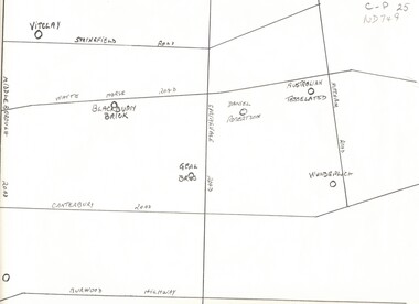
Map, Potteries, n.d
Sketch map of location of potteries in the area bounded by Middleborough, Springfield, Mitcham Roads and Burwood Highway.Sketch map of location of potteries in the area bounded by Middleborough, Springfield, Mitcham Roads and Burwood Highway.Sketch map of location of potteries in the area bounded by Middleborough, Springfield, Mitcham Roads and Burwood Highway.potteries, vitclay pipes pty ltd, blackburn brick and tile co., geal bros., wunderlich limited, australian tesselated tile co. pty ltd., daniel robertson australia pty ltd -
Southern Sherbrooke Historical Society Inc.
Map, "South Riding, Shire of Sherbrooke", Jun-92
A3 maps (2) showing subdivisions in Shire of Sherbrooke South Riding, 2 copies of eachshire of sherbrooke -
 Ringwood RSL Sub-Branch
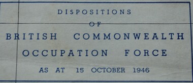
Document, July 1946
Map of Southern Japan showing dispositions of British Commonwealth Occupation Forces as at 15 October 1946 -
 Otway Districts Historical Society
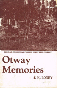
Book, J.K. Loney, Otway memories. J.K. Loney, 1971
A family history of the Thomas James McMinn family and the settlement on Block 33 on the Wait-a-while Road, Wyelangta, Victoria.Otway memories. J.K. Loney. Soft cover. i, 53 p.; illus, map. 1971the beechy; roads; forests; sawmills; bushfires; history; visitors' guide; reminiscences; wyelangta; -
 Queenscliffe Maritime Museum
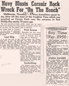
Mixed media - Wreck of the TIME, News articles re the wreck of the TIME, c1949 newspapers
Shipwreck & rescueSS TIME wreck, Corsair Reef & Queenscliffe Lifeboat.News articles, photos, map & report re SS TIME wreck at Corsair Reef c1949Reverse " NIL ".historical references -
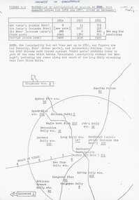 Bendigo Historical Society Inc.
Document - Chinese Distribution in Eaglehawk and Sandhurst in 1861
Chinese Distribution in Eaglehawk and Sandhurst in 1861. Sketch and Map of the Chinese showing their population based on the census.history, bendigo, eaglehawk, chinese, sandhurst -
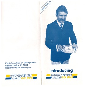 Bendigo Historical Society Inc.
Ephemera - "Bendigo Bus" new routes, 1960 -1970s
BHS CollectionGlossy Brochure introducing "Bendigo Bus" new routes. Map of the new routes and information hotline.history, bendigo, merle lummis collection, bendigo bus -
Kew Historical Society Inc
Archive (Sub-series) - Subject File, Kew Historical Society, GARDINER, John, 1958
Various partiesReference, Research, InformationSecondary Values (KHS Imposed Order)Subject file containing photocopied notes, articles and a map relating to the Hawthorn pioneer, John Gardinerhistory - european settlement - squatters - hawthorn - melbourne - victoria, john gardiner -- pioneerhistory - european settlement - squatters - hawthorn - melbourne - victoria, john gardiner -- pioneer -
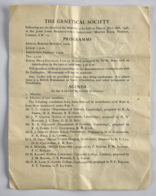 National Wool Museum
Document - The Genetical Society, 1946
This item is associated with the Secretary of the New South Wales Graziers Association, Mr J. W. AllenFour page folded leaflet outlining the agenda for a business meeting. A map is printed on the back page.Front: THE GENETICAL SOCIETY / Following are the details of the MEETING to be held on FRIDAY, JULY 26th, 1946, / at the JOHN INNES HORTICULTURAL INSTITUTION, MOSTYN ROAD, MERTON, / LONDON, S.W. 19. -
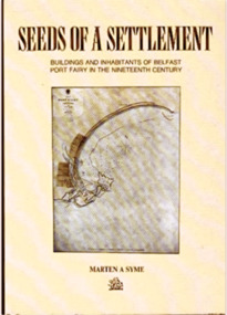 Port Fairy Historical Society Museum and Archives
Book, Roebuck, Seeds of settlement :Buildings and Inhabitants of Belfast Port Fairy in the Nineteenth Century, 1991
Seeds of a settlement : a perspective of Port Fairy in the second half of the nineteenth century through the surviving buildings and their inhabitants / Marten A. Symexii, 158, [1] p. folded leaf of plate : ill., maps, ports. ; 25 cm. non-fictionSeeds of a settlement : a perspective of Port Fairy in the second half of the nineteenth century through the surviving buildings and their inhabitants / Marten A. Symeport fairy (vic.) -- history, book, history, biography, port fairy, residents, buildings