Showing 23768 items
matching matthew-creek
-
 Eltham District Historical Society Inc
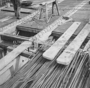
Album - Photograph, J.A. McDonald, General; Albion Street and Eltham-Yarra Glen Road, Oct. 1955
General – Country Roads Board Albion Street bridge over Moonee Ponds Creek, Brunswick West Deck Forms October 1955Record of various Shire of Eltham infrastructure works undertaken during the period of 1952-1962 involving bridge and road reconstruction projects, sometimes with Eltham Shire Council Project Reference numbers quoted. It was during this period that a number of significant improvements were made to roads and new bridges constructed within the shire that remain in place as of present day (2022). In many situations, the photos provide a tangible visible record of infrastructure that existed throughout the early days of the Shire. The album was put together by or under the direction of the Shire Engineer, J.A. McDonald.infrastructure, road construction, shire of eltham, 1955-10, albion street, bridge construction, country roads board, benchmark studies, brunswick west, moonee ponds creek -
 Eltham District Historical Society Inc
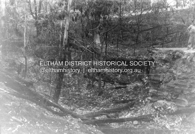
Album - Photograph, J.A. McDonald, Salters Rush Road, Smiths Gully, Aug. 1962
Salters Rush Road, Smiths Gully Bridge over Salters Rush Creek following bush fires 15-16 Jan. 1962Record of various Shire of Eltham infrastructure works undertaken during the period of 1952-1962 involving bridge and road reconstruction projects, sometimes with Eltham Shire Council Project Reference numbers quoted. It was during this period that a number of significant improvements were made to roads and new bridges constructed within the shire that remain in place as of present day (2022). In many situations, the photos provide a tangible visible record of infrastructure that existed throughout the early days of the Shire. The album was put together by or under the direction of the Shire Engineer, J.A. McDonald.H941 stamped on reverse (film processing #)infrastructure, shire of eltham, bridge construction, road construction, 1962-08, bushfires, salters rush road, smiths gully, victorian bushfires - 1962 -
 Eltham District Historical Society Inc
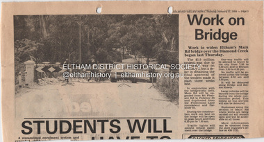
Document - Property Binder, Main Road Bridge, Eltham
Newspaper article: Diamond Valley News, 31 January 1984, work to begin on widening of Main Road Bridge over Diamond Creek.main road, bridges, main road bridge, diamond creek, eltham (vic) -
 Eltham District Historical Society Inc
Negative - Photograph, J.A. McDonald, Heidelberg-Kinglake Road, 3 Nov. 1959
Job 56M431 Contractors Wolf and Wood Yow Yow Creek Bridge Curve improvement north of bridge site 3 November 1959Record of various Shire of Eltham infrastructure works undertaken during the period of 1952-1962 involving bridge and road reconstruction projects, sometimes with Eltham Shire Council Project Reference numbers quoted. It was during this period that a number of significant improvements were made to roads and new bridges constructed within the shire that remain in place as of present day (2022). In many situations, the photos provide a tangible visible record of infrastructure that existed throughout the early days of the Shire. The album was put together by or under the direction of the Shire Engineer, J.A. McDonald.infrastructure, shire of eltham, bridge construction, heidelberg-kinglake road, road construction, yow yow creek, 1959-11-03 -
 Eltham District Historical Society Inc
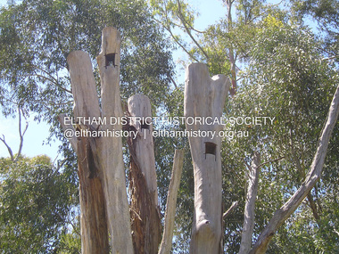
Photograph, Fay Bridge, Nesting hollows for birds in dead tree trunks, St Andrews, 29 January 2020
Artificial nesting hollows in tree trunks to encourage wildlife situated near St Andrews Market on the road to Kinglake just near the creekfay bridge collection, 2020-01-29, kinglake road, nesting hollow, st andrews -
 Phillip Island and District Historical Society Inc.
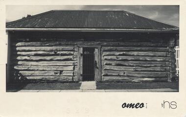
Photograph - Post Card, 1974
Postcard sent to Jean Archibald by Helen Jansson whilst holidaying at Mt Beauty, Omeo and Fall's Creek area. Donated by Helen Jansson.Black & White postcard of the Gaol in Omeo. Letter on back to Jean Archibald from Helen Jansson posted on the 18th April 1974."Omeo - Vic" by HSomeo gaol, mrs helen jansson, jean archibald -
 Greensborough Historical Society
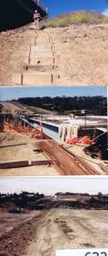
Photographs, Gary Partington, Greensborough By-Pass, 1986_
The Greensborough by-pass extends from Grimshaw Street in the south to Diamond Creek Road in the north. It is intersected by the eastern end of the Metropolitan Ring Road.Unpublished photographs of the construction of the Greensborough by-pass.21 colour photographs of the construction phase of the Greensborough By-pass.greensborough bypass, roads, greensborough, gary partington, metropolitan ring road -
 Greensborough Historical Society
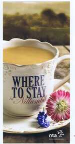
Leaflet, Nillumbik Tourist Association, Where to stay in Nillumbik, 17/10/2015
Lists 10 major tourist accommodations in: Bundoora, Diamond Creek, Eltham, Hurstbridge, Kangaroo Ground, Panton Hill, Research, St AndrewsColour, printed both sides, map of area, A4 folded twicenillumbik -
 Greensborough Historical Society
Newspaper clipping, Fiona Cameron, Pioneer bridge is demolished, by Fiona Cameron, 1974_
Describes the removal of the bluestone bridge abutment on the north side of the Plenty River in Greensborough, to make way for the Diamond Creek Road bridge duplication.Photocopy of news articleplenty river, diamond creek road -
 Greensborough Historical Society
Article, Greensborough Historical Society et al, Jonathan Lionel Mills, 1914-1918
A short article about Jonathan Lionel Mills and his service in World War 1. He was born in Upper Diamond Creek (Plenty).One page, text and colour images.world war 1 project, jonathan lionel mills -
 Greensborough Historical Society
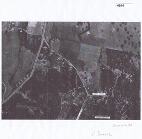
Aerial Photograph, Greenhills Aerial View, 1945_
Section from the 1945 aerial survey of Greensborough, including part of Diamond Creek Road, Greenhill Road, Crest Street and Albion Crescent.Photocopy of part of 1945 aerial survey. Some streets have been marked.greenhills -
 Greensborough Historical Society
Newspaper Clipping, Diamond Valley Leader, Creekers beaten by mighty Darebin Falcons but still proud, 27/09/2017
Had this Diamond Creek team been brought together in any other era, its trophy cabinet would be flush with premiership cupsNews article 1 page, black text, colour image.vflw, diamond creek football club, darebin falcons football club, victorian football league women -
 Eltham District Historical Society Inc
Negative - Photograph, George W. Bell, Foot Bridge to Eltham High School, c.1960
Footbridge over the Diamond Creek at Dalton Street near Withers Way. It has since been replaced and integrated into the Wingrove Park Trail.This photo forms part of a collection of photographs gathered by the Shire of Eltham for their centenary project book,"Pioneers and Painters: 100 years of the Shire of Eltham" by Alan Marshall (1971). The collection of over 500 images is held in partnership between Eltham District Historical Society and Yarra Plenty Regional Library (Eltham Library) and is now formally known as the 'The Shire of Eltham Pioneers Photograph Collection.' It is significant in being the first community sourced collection representing the places and people of the Shire's first one hundred years.Digital image 4 x 5 inch B&W Negsepp, shire of eltham pioneers photograph collection, eltham, eltham high school, foot bridge, bridge, dalton street, diamond creek (creek), george w. bell collection, wingrove park trail, withers way -
 Eltham District Historical Society Inc
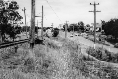
Photograph, Looking north along Main Road from Cecil Street intersection, Eltham, February 1968, Feb 1968
Shows position of under road water course, which also went under railway line to the Diamond Creek and Cecil Street sign.In February 1968 an unknown person took a series of photos from the Eltham Hotel at Pitt Street heading north along Main Road through the shopping centre to just north of Elsa Court covering the length of the section of Main Road which was duplicated shortly thereafter. Shows the condition and environment of the streesscape of Main Road, Eltham immediately prior to the duplication between Pitt Street and Elsa Court through the shopping centre. Also shows a number of shops and businesses that operated at that time.Black and white photographduplication, eltham, main road, cecil street, railway line, watercourse, floods -
 Hume City Civic Collection
Photograph
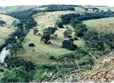
Lochton Flour Mill was established in the 1850s and is only one of a few surviving mills in Victoria. It is situated on a horseshoe bend on the Deep Creek at Bulla.A coloured photograph of a horse shoe bend in a river and the open flood plain. The river is tree-lined. The ruins of a stone building are on the river bend. A damaged fence and prickly pears are in the foreground.lochton mill, deep creek, hunter, william morrison, george evans collection -
 Mt Dandenong & District Historical Society Inc.
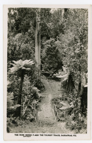
Photograph, Tourist Track, Sassafras. Vic, c1920
The tourist track running alongside the creek from Sassafras Mechanics’ Hall to Emerald. In the early 1900s the track started at Rostrevor Guest House.Black & White postcard P1501 from the Rose Series. Shows a log bridge along a tree fern lined section of the Tourist Track.On reverse - POST CARD A Real Photograph. Produced in Australia.rose series, sassafras, track, postcard, mechanics' hall -
 Mt Dandenong & District Historical Society Inc.
Photograph, The Tourist Track, Sassafras. Vic, c1920
The tourist track running alongside the creek from Sassafras Mechanics’ Hall to Emerald. In the early 1900s the track started at Rostrevor Guest House.Black and white photograph. Rose Series P. 4825 postcard showing a footbridge along a Tourist rack surrounded by bush and tree ferns.rose series, rostrevor, mechanics' hall, sassafras, track -
 Mt Dandenong & District Historical Society Inc.
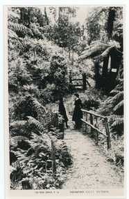
Photograph, Sassafras Gully, Victoria, c1920
The tourist track running alongside the creek from Sassafras Mechanics’ Hall to Emerald. In the early 1900s the track started at Rostrevor Guest House.Black and white copy of Rose Series Post card P. 74 showing two young women standing on a footbridge at Sassafras Gully. A set of steep steps can be seen above them.rose series, track, footbridge, bridge, sassafras -
 Mt Dandenong & District Historical Society Inc.
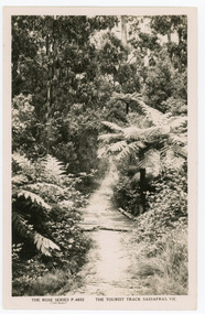
Photograph, The Tourist Track, Sassafras.Vic, c1920
The tourist track running alongside the creek from Sassafras Mechanics’ Hall to Emerald. In the early 1900s the track started at Rostrevor Guest House.Black and white Rose Series postcard P. 4832 showing a section of the Tourist Track in Sassafras surrounded by tree ferns and bush.On Reverse POST CARD A Real Photograph. Produced in Australia.sassafras, rose series, postcard, track -
 Kiewa Valley Historical Society
Photos - Kancoona Primary School 1960s
Kancoona School is at Kancoona/Running Creek which runs off the Kiewa Valley Highway. In the 1960s small communities had their own school.The students and families were part of the Kiewa Valley. Social history of small schools and education.Photos of 1. Kancoona Primary School (School Number 3576) students in 1967 2. Names of 1967 students in photo and Teacher Alan Crilly 1963-1967 3. Kancoona P.S. 4. House in Mt BeautyStudent photo has names of students written on the back and school photo has dates for head teacher.1960skancoona, running creek, kancoona primary school -
 Whitehorse Historical Society Inc.
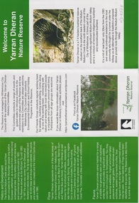
Pamphlet, Yarran Dheran, 26/02/2025
4 pamphlets 1. Welcome to Yarran Dheran Nature Reserve 2. Stepping Stones for Wildlife 3. Birds of Yarran Dheran 4. Butterflies4 pamphletsnon-fiction4 pamphlets 1. Welcome to Yarran Dheran Nature Reserve 2. Stepping Stones for Wildlife 3. Birds of Yarran Dheran 4. Butterfliesyarran dheran, city of whitehouse -
 Clunes Museum
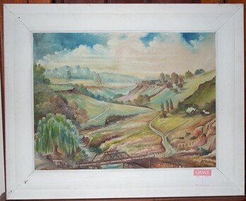
Painting, RICHARD FORD, CIRCA 1923
OIL PAINTING FEATURING BRIDGE ACROSS CRESWICK CREEK IN THE STATION FLAT AREA. NORTH WEST OF CLUNES. BRIDGE IS NOW REPLACED BY "FORD".OIL PAINTING BY CLUNES ARTIST RICHARD FORD.local history, illustration, oil, ford richard -
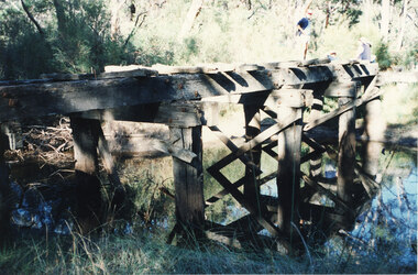 Halls Gap & Grampians Historical Society
Photograph - Coloured, C 1980s
This is a photo of one of the trestle bridges on the Heatherlie Quarry train line. It is located near the current site of "the Pines" campground.Photo shows an angle a derelict bridge with many sleepers missing. Thick bush and trees on left side with weeds in the front. The bridge is over a shallow creek. At the far end of the bridge a man wearing a pink cap and blue jumper stands looking towards camera. Three adults are seated and partly out of picture.structures, bridges, quarrying, heatherlie -
 Kiewa Valley Historical Society
Photos - A. Dartmouth Dam B.-E. Kiewa Valley
A. x3 colored photos of Dartmouth Dam during construction B. x5 black & white photos of Falls Creek and Kiewa Valley C. x7 black & white photos of groups of people D. x5 black & white photos and 3 colored photos of people in clubs E, x1 black & white photo -
 Bendigo Historical Society Inc.
Book - RAILWAYS COLLECTION: THE AUSTRALIAN RAILWAY HISTORICAL SOCIETY NOVEMBER 1956, 1956
Railways Collection - Article from Pages 160-161 of The Australian Railway Historical Society November 1956 Bulletin No. 229. There is a photo of opening day of the Port Darwin -Pine Creek Railway on 1.10.1889. An A Class train is shown. Page 161 has an article Victorian Rail Services now and then by John D. Keating.John D. Keatingrailways, bendigo to melbourne, opening day of the port darwin -pine creek railway -
 Bendigo Historical Society Inc.
Map - TANDARRA : COUNTY OF BENDIGO, 14-3-24
Map. Tandarra, County of Bendigo, Talambe, Yallook, Neilborough, Whirrakee, Kamarooka. Myers Creek, Tandarra Estate. Photo-Lithographed at the Department of Lands and Survey, Melbourne by W.J. Butson, 14-3-24. Price 1/-. By authority Albert J. Mullett, Government Printer, Melbourne. (number 25 in map cupboard 1)Albert J. Mullett, Government Printer, Melbourne.map, bendigo, tandarra -
 Bendigo Historical Society Inc.
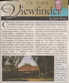
Newspaper - JACK PERRY COLLECTION: NEWSPAPER FOUNDRIES
Newspaper article discussing Harkness, Roberts & Son United Ironworks, Myers St later in Wills St where Target is now, Carter and Brown, Creek St., Phoenix foundry in Wattle St., Horsfield in Havilah Road, Central Foundry Eaglehawk Road ( Osborne's ) Eaglehawk Foundry, Caldwell's Road, Jobs Hill.bendigo, mining, harkness foundry -
Bendigo Historical Society Inc.
Map - DARGILE : COUNTY OF BENDIGO, November 1953
Map. Dargile, County of Bendigo, County of Rodney, Cornella Creek, Northern Highway, Crosbie, Redcastle, Knowsley East, Heathcote, Costerfield, Moormbool West. By authority W.M. Houston, Government Printer. Drawn and reproduced at the Department of Lands and Survey, Melbourne. November 1953. Price 2/-. (number 115 in map cupboard 1)W.M Houston, Government Printermap, bendigo, dargile -
Bendigo Historical Society Inc.
Map - CROSBIE : COUNTY OF BENDIGO, 1970
Map. Crosbie, County of Bendigo, County of Rodney, Toolleen, Weston, Dargile, Knowsley East, Redcastle, Township of Toolleen, Northern Highway, Mt.Pleasant Creek. By Authority R.H. Rixon, Government Printer, Melbourne. Drawn and reproduced at the Department of Lands and Survey, Melbourne. 1970. Price $1.00. (number 114 in map cupboard 1)R.H. Rixon, Government Printer, Melbourne.map, bendigo, crosbie -
Bendigo Historical Society Inc.
Map - WESTON : COUNTY OF BENDIGO : COUNTY OF RODNEY, 4-5-21
Map. Weston, County of Bendigo, County of Rodney, Muskerry, Crosbie, Knowsley East, Knowsley, Axedale. Back Creek. By authority A.J. Mullett, Government Printer, Melbourne. Photo-Lithographed at the Department of Lands and Survey, Melbourne by W.J. Butson 4-5-21. Price 1/-. (number 108 in map cupboard 1)A.J. Mullett, Government Printer, Melbourne.map, bendigo, weston