Showing 8877 items
matching south road
-
 Eltham District Historical Society Inc
Photograph, Liz Pidgeon, Heritage Excursion; East of Eltham, 6 Sep 2014, 20 May 2017
Newsletter No. 218, September 2014 September Excursion - East of Eltham Walk In Newsletter No. 197, March 2011, there was a brief history of Crown Allotment 15 Section 5 Parish of Nillumbik (CA 15) a parcel of land of a quarter of a square mile extending from Eucalyptus Road to Reynolds Road at the eastern extremity of Eltham. From the 1940s it was known as Stokes orchard. In later years it has been subdivided for residential purposes but leaving significant areas as power line and water supply reserves and bushland reserves that are habitat for the threatened For our excursion on 6th September we intend to walk through CA 15 to a bushland reserve east of Reynolds Road. The walk will traverse the boundary between suburban Eltham and the non-urban areas to the south and east. This is a pleasant walk through residential areas and bushland. Along the way we will discuss the early and more recent history of CA 15 as well as local natural history and geology. This walk is about 3.5 km in length and will take 2 to 2.5 hours. It will start at 2pm at the corner of Eucalyptus Road, Pitt Street and Nyora Road.Born Digitaleltham east, eltham district historical society, heritage excursion, activities, nyora road, reynolds road, gum tree road reserve, diosma road, stokes orchard, eucalyptus road -
 Eltham District Historical Society Inc
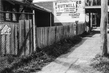
Photograph, Looking south along the east side of Main Road towards York Street, Eltham, February 1968, Feb 1968
Shows Eltham Stock and Poultry Feed Store. Site of current Le Pine Funeral Home In February 1968 an unknown person took a series of photos from the Eltham Hotel at Pitt Street heading north along Main Road through the shopping centre to just north of Elsa Court covering the length of the section of Main Road which was duplicated shortly thereafter. Shows the condition and environment of the streesscape of Main Road, Eltham immediately prior to the duplication between Pitt Street and Elsa Court through the shopping centre. Also shows a number of shops and businesses that operated at that time.Black and white photographduplication, eltham, main road, briquettes, fuel merchant, le pine funeral home, york street, a.r warren, eltham feed store -
 Eltham District Historical Society Inc
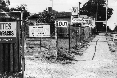
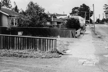
Photograph, Looking south along the east side of Main Road from Henry Street to Bridge Street, Eltham, February 1968, Feb 1968
Shows Warrens Fuel Merchant yard and Eltham Feed Store. Site of current Le Pine Funeral Home In February 1968 an unknown person took a series of photos from the Eltham Hotel at Pitt Street heading north along Main Road through the shopping centre to just north of Elsa Court covering the length of the section of Main Road which was duplicated shortly thereafter. Shows the condition and environment of the streesscape of Main Road, Eltham immediately prior to the duplication between Pitt Street and Elsa Court through the shopping centre. Also shows a number of shops and businesses that operated at that time.Black and white photographduplication, eltham, main road, briquettes, fuel merchant, le pine funeral home, york street, a.r warren, eltham feed store -
 Eltham District Historical Society Inc
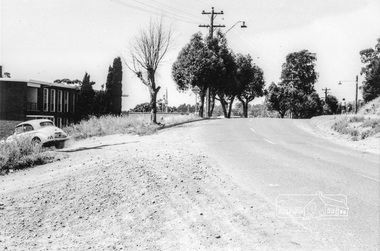
Photograph, Eltham Shire Office, Main Road, Eltham, February 1968, Feb 1968
Shows the new Shire offices prior to the south wing addition provided for Engineering Department and Library use. In February 1968 an unknown person took a series of photos from the Eltham Hotel at Pitt Street heading north along Main Road through the shopping centre to just north of Elsa Court covering the length of the section of Main Road which was duplicated shortly thereafter. Shows the condition and environment of the streesscape of Main Road, Eltham immediately prior to the duplication between Pitt Street and Elsa Court through the shopping centre. Also shows a number of shops and businesses that operated at that time.Black and white photographduplication, eltham, main road, eltham shire offices, shillinglaw trees -
 Eltham District Historical Society Inc
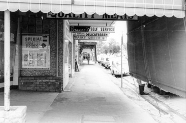
Photograph, Shopping centre, Main Road, Eltham, February 1968, Feb 1968
Main Road shops from midway between Luck and Pryor Streets, looking south along the east side. Includes Browne's Self Service, Delicatessen, Dairy Queen, Commonwealth Bank, Mac's Meats and Thompson's Chemist.In February 1968 an unknown person took a series of photos from the Eltham Hotel at Pitt Street heading north along Main Road through the shopping centre to just north of Elsa Court covering the length of the section of Main Road which was duplicated shortly thereafter. Shows the condition and environment of the streesscape of Main Road, Eltham immediately prior to the duplication between Pitt Street and Elsa Court through the shopping centre. Also shows a number of shops and businesses that operated at that time.Black and white photographduplication, eltham, main road, shopping centre, thompson's pharmacy, mac's meats, delicatessen, dairy queen, commonwealth bank, browne's self service -
 Eltham District Historical Society Inc
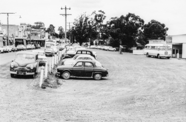
Photograph, Looking south across to the shopping centre from the west side of Main Road, Eltham, February 1968, Feb 1968
Shows Bryant Motors beside Railway Station.In February 1968 an unknown person took a series of photos from the Eltham Hotel at Pitt Street heading north along Main Road through the shopping centre to just north of Elsa Court covering the length of the section of Main Road which was duplicated shortly thereafter. Shows the condition and environment of the streesscape of Main Road, Eltham immediately prior to the duplication between Pitt Street and Elsa Court through the shopping centre. Also shows a number of shops and businesses that operated at that time.Black and white photographduplication, eltham, main road, luck street, bryant motors, buses -
 Eltham District Historical Society Inc
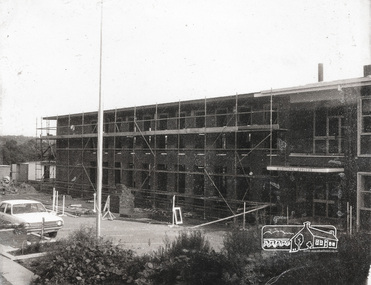
Photograph, Completing the south wing of Eltham Shire Offices for Library and Planning Departments, 1971, 1971
Completing the south wing of Eltham Shire Offices for Library and Planning Departments, Main road, Eltham. Building demolished 1990s.1 photographBack: "Shire Office extensions 1971" eltham, shire of eltham, eltham library, building, planning department -
 Eltham District Historical Society Inc
Photograph, Para Road, Montmorency, industrial area looking south from Plenty River Bridge on boundary of Shire of Eltham
Colour photograph02076, montmorency (france) photo album, montmorency, para road, plenty river, industry -
 Eltham District Historical Society Inc
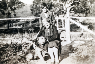
Photograph, Arrowsmith family members taken at front gate of 523 Main Road, Eltham
View is looking south west from inside the front gate. Main Road is running across the picture just past the trees and the open area is where the current day Fitzsimons Lane runsShows the area of Fitzsimons Lane prior to developmentBlack and white photograph - digital fileeltham, main road, fitzsimons lane, porter street, castledine -
 Eltham District Historical Society Inc
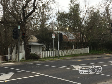
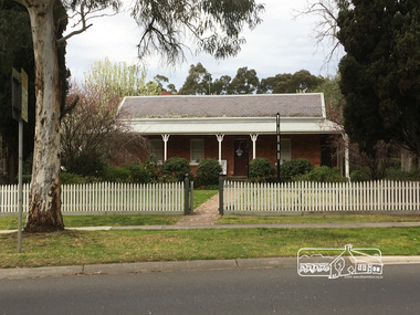
Photograph, Peter Pidgeon, Whitecloud Jarrold Cottage c.1850 & boot makers cottage. The fence was knocked down by a car in 1974, Main Road, Eltham, 2 Sep 2017
Heritage Excursion - An Eltham South Ramble, 2 Sep 2017Born Digitalactivities, eltham district historical society, eltham south, heritage excursion, local history centre -
 Eltham District Historical Society Inc
Photograph, 1934 Floods at Eltham
... Falkiner Street, beside the Main Road bridge at Eltham South from... Falkiner Street, beside the Main Road bridge at Eltham South from ...Published in the Diamond Creek Basin Study, 1980 and identified at Diamond Creek, locality not identified, 1934. The location is actually looking south across the Diamond Creek towards Falkiner Street, beside the Main Road bridge at Eltham South from what is now part of Wingrove Park opposite Antoinette Boulevard. The bridge railing is just visible to the left of image. The large leaning Manna Gum beside the bridge still stands in 2021 alongside the Diamond Creek trail. In 1934 extensive flooding of the Yarra River and Diamond Creek set new records for flood plain level (Eltham Chronology, EDHS)Black and white photographCopied by Hugh Fisher, Photographer, 6 York Street Eltham A1678B Floods- Eltham - 1934floods, yarra river, eltham, flooding, diamond creek, flood -
 Eltham District Historical Society Inc
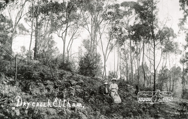
Photograph, Tom Prior, Dry Creek, Eltham
At the south of Research, the creek that starts at Geoff Joslyn's and follows Mount Pleasant Road and it eventually flows into the Yarra. Possibly Ivy Reynolds' aunty shown.The Reynolds family were early settlers in Research. The Reynolds/ Prior collection of photographs were taken by Tom Prior, the maternal uncle of Ivy Reynolds, around 1900 and the 60 photos in the album give a fine overview of many of the landmarks of Research and Eltham over 100 years ago. lvy lived in the family home for many years at 106 Thompson Cres Research. Ivy's father, Ernst Richard Reynolds and grandfather, Richard Reynolds, lived at the same address. Ivy's father Richard worked for Mr. Trail on his property in Research. Reynolds Road is named after the family. Mr Tom Prior (wife Eva) worked at the Melbourne zoo. He was very innovative and made his own camera, using the black cloth hood to exclude the light. The photographs are a reminder of the rural nature of Research and Eltham and its rich heritage. Black and white photograph mounted in an album, the Reynolds/Prior Photograph Collection, this being one of 53 reproduced black and white images of early Eltham.The Reynolds/Prior Photograph Collection, Presented to the Eltham District Historical Society, 14 June 2006 by Ross McDonald. A second copy was also presented to the Andrew Ross Museum, Kangaroo Groundreynolds prior collection, creek, eltham -
 Eltham District Historical Society Inc
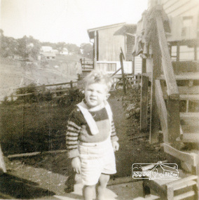
Photograph, Graeme Landy (approx. 3); looking south from the backyard of 38 Beattie Street, Montmorency, towards Rattray Road, c.1952, 1952c
Digital copy of black and white photograph38 beattie street, graeme landy, montmorency -
 Eltham District Historical Society Inc
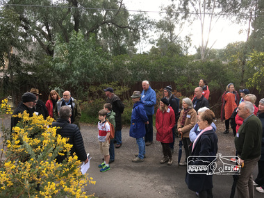
Photograph, Peter Pidgeon, Great turnout for our heritage excursion; outside Shoestring in Metery Road, Eltham, 2 Sep 2017
Heritage Excursion - An Eltham South Ramble, 2 Sep 2017Born Digitalactivities, eltham district historical society, eltham south, heritage excursion, local history centre -
 Eltham District Historical Society Inc
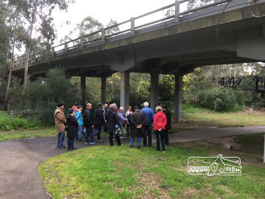
Photograph, Peter Pidgeon, Main Road Bridge over Diamond Creek, 2 Sep 2017
Heritage Excursion - An Eltham South Ramble, 2 Sep 2017Born Digitalactivities, eltham district historical society, eltham south, heritage excursion, local history centre -
 Eltham District Historical Society Inc
Photograph, Peter Pidgeon, Site of the original Catholic Church but was too far from centre of community, Main Road, Eltham, 2 Sep 2017
Heritage Excursion - An Eltham South Ramble, 2 Sep 2017Born Digitalactivities, eltham district historical society, eltham south, heritage excursion, local history centre -
 Eltham District Historical Society Inc
Photograph, Peter Pidgeon, Wingrove Cottage 1858 home of C.S Wingrove, Secretary Eltham Roads Board 1857 & Shire of Eltham 1871, 2 Sep 2017
Heritage Excursion - An Eltham South Ramble, 2 Sep 2017Born Digitalactivities, eltham district historical society, eltham south, heritage excursion, local history centre