Showing 23767 items
matching matthew-creek
-
 Bendigo Historical Society Inc.
Map - HAWKESTONE : COUNTY OF BENDIGO, December 1953
Map. Hawkestone, Parish, County of Bendigo, County of Talbot, Sutton Grange, Redesdale, Faraday, Elphinstone, Metcalfe, Lyell, Coliban River, Myrtla Creek. By Authority W.M. Houston, Government Printer. Drawn and reproduced at the Department of Lands and Survey, Melbourne. December 1953. Price 2/-. (number 99 in map cupboard 1)W.M. Houston, Government Printer.map, bendigo, hawkestone. -
Bendigo Historical Society Inc.
Map - SALISBURY WEST : COUNTY OF BENDIGO, 3-3-1944
Map. Salisbury, County of Bendigo, County of Gladstone, Powlett, Yarrayne, Bridgewater, Inglewood, River Loddon, Bullabul Creek, Glenalbyn, Kurting. By Authority H.E. Daw, Government Printer, Melbourne. Drawn and reproduced at the Department of Lands and Survey, Melbourne., 3-3-1944. Price 5/-. (number 94 in map cupboard 1)H.E. Daw, Government Printer, Melbourne.map, bendigo, salisbury west -
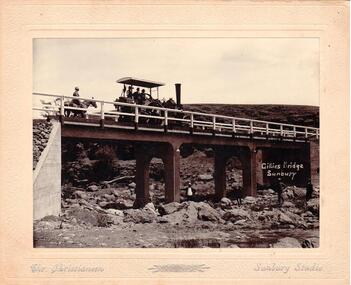 Hume City Civic Collection
Photograph
Chris. Christiansen was a barber in Sunbury. He also ran a photographic studio from 1892 - 1916. His business was situated on the corner of Evans and Brook Streets. The Gillies Bridge is Situated on the Wildwood Road just off the Lancefield Road.A mounted sepia photograph of the Gillies Bridge at Sunbury. Across the bridge there are three men on a steam roller and one man behind on horseback. There are four men standing across the creek bed. The mounting is cream, 2 cm wide with silver writing under the photo. Cream mounting - 2 cm wide with silver inscriptionsGILLIES BRIDGE / SUNBURY / CHR. CHRISTIANSEN /gillies bridge, wildwood bridge, bridges, horses, christiansen, chris, photographers, animals, steam rollers, sunbury, men, clothing and dress, george evans collection -
 Southern Sherbrooke Historical Society Inc.
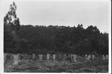
Photograph - Photo - Bagged-up spuds awaiting collection on Hermon's farm
B&W photo showing rows of filled potato sacks in a field at Hermon's farm on Black Hill Road, Menzies Creek. Land was leased from Forest Dept. Trees are in the middle ground and behind them, the ridge of Ridge Road can be seen. See also M0055 taken from the same position. -
 Southern Sherbrooke Historical Society Inc.
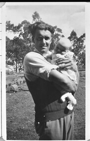
Photograph - Photo - Bill Hermon with his first daughter, Joy, in the 1940s
B&W photo of Bill Hermon holding a baby of about three months of age. Bill is wearing a sleeveless pullover over a shirt with rolled-up sleeves. They appear to be on the Hermon farm at Menzies Creek. In the field behind them is a metal hand roller. Beyond a small row of shrubs is a child's tricycle. 1940s. -
 Bendigo Historical Society Inc.
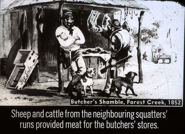
Slide - DIGGERS & MINING. STORES AT THE DIGGINGS, c1852
Diggers & Mining. Stores at the diggings. Butcher's Shamble, Forest Creek, 1852. Sheep and cattle from the neighbouring squatters' runs provided meat for the butchers' stores. Slide shows miner checking out the meat for sale other items are also for sale. Markings: 23 994.LIF. 5. Used as a teaching aid.hanimounteducation, tertiary, goldfields -
 Bendigo Historical Society Inc.
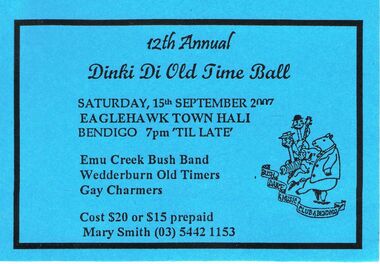
Document - PETER ELLIS COLLECTION: TICKET TO DINKI DI OLD TIME BALL 2007, 15th September, 2007
Two blue cards for the 12th Annual Dinki Di Old Time Ball Saturday 15th September 2007 at the Eaglehawk Town Hall Bendigo7pm 'til late. Emu Creek bush Band, Wedderburn Old Timers, Gay Charmers. Cost $20 or $15 prepaid, Mary Smith (03) 5442 1153entertainment, dance, dinki di old time ball -
 Bendigo Historical Society Inc.
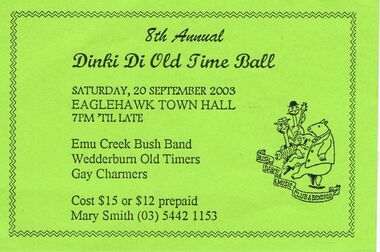
Document - PETER ELLIS COLLECTION: DINKI DI OLD TIME BALL 2003
Green card to 8th Annual Dinki Di Old time Ball to be held Saturday 20 September 2003 at the Eaglehawk Town Hall 7pm till late. Emu Creek bush Band, Wedderburn Old Timers, Gay Charmers. Cost $15 or $12 prepaid Mary Smith (o3) 5442 1153.entertainment, dance, dinki di old time ball -
 Bendigo Historical Society Inc.
Slide - DIGGERS & MINING: THE DIGGINGS - THE DIGGERS
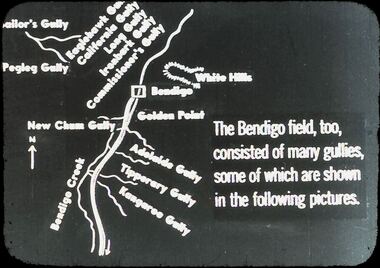
Diggers & Mining: The Digging - The Diggers. Slide depicts areas of Bendigo. Golden Point, New Chum Gully, Adelaide Gully, Tiperary Gully, Kangaroo Gully, Bendigo Creek, Pegleg Gully, Sailor's Gully, California Gullly, LongGully, Commissioner's Gully. Markings: 17 994.LIF:6. Used as a teaching aid.hanimounteducation, tertiary, goldfields -
 Bendigo Historical Society Inc.
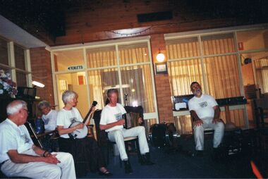
Photograph - PETER ELLIS COLLECTION: EMU CREEK BUSH BAND, 25th November, 2007
Colour photograph. Members of Emu Creek Bush Band sitting in hall in front of windows. Toilets sign visible. Banjo, accordian and drum. Back of photo reads: Bendigo Retirement Village Sunday Nov. 25 2007 L-R Des Skinner, Olive Dobbyn, Julie and Don Maneypeney Peter Ellis.entertainment, music, emu creek bush band -
Tarnagulla History Archive
Allen marriage certificate (copy), 3rd October 1894
Donald Clark Collection.Photocopy of a Certificate of Marriage from Dunolly Gladstone district. Parties are Ebenezer Allen (31 years) of Hillsborough Farm, Kangedaar Creek near Tarnagulla and Jane Esther Laurie (27 years) of Laurie near Tarnagulla. Minister is Robert Thomson, Presbyterian Minister. Marriage took place at Red Hill Farm, Tarnagulla. -
 Bendigo Historical Society Inc.
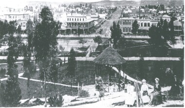
Photograph - LANDSCAPE - BENDIGO - PRE-POST OFFICE
Photograph - black and white. Photo of a view over Bendigo, Shamrock Hotel in middle left. Group of women in immediate foreground. Rosalind Park, creek then bare land. Written on back of photo 'Pre-Post Office Blng - began 1883, Open 1887.' Came with negatives under name of Davidson, negatives are not of the photo.place, landscape view, hargreaves street from rosalind par, bendigo. pre- post office. rosalind park. landscape -
 Bendigo Historical Society Inc.
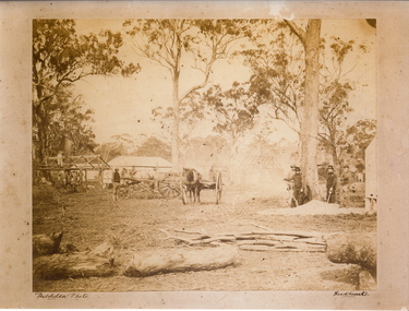
Photograph - MYERS CREEK DIGGINGS, c1867
Sepia photograph: Myers Creek Diggings, Victoria, Australia. Photographed by Claver Carroll from original photo by Batchelder. Hut under construction with man on top of it on left, two horse and carts in center, four men with shovels on right. Tents and partly constructed hut in background. Inscriptions/Markings Batchelder Photo, Sandhurst.Claver Carrollplace, mining site, myer's creek diggings -
 Eltham District Historical Society Inc
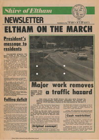
Journal - Newsletter, Shire of Eltham, Shire of Eltham newsletter, 1979
Articles, some with photos. Subjects include President's message, Eltham-templestowe intersection, indoor recreational centre, Bridge over Watsons Creek, town square, list of councillors, forward planning, recreational faciliaites including Eltham town park, Hurstbridge hall, roads, community welfare services, eltham Community and reception centre opening, amenities for youth, concrete bridge at Arthurs creek and Mitton's Bridge at St Andrew's Newsprint, 4 pages harry gilham collection, intersection, round-about, recreation, recreational centre, watsons creek, town square, councilors, newsletter, planning, parks, hurstbridge hall, community welfare service, roads, eltham community and reception centre, youth, skateboard track, mitton's bridge, arthur's creek, fitzsimons lane, main road, road construction, rondabout -
 Greensborough Historical Society
Map, Melbourne and Metropolitan Board of Works. Survey Division, MMBW, Yarra 2500 / 13.21. Central Greensborough, 1979_05
Melbourne and Metropolitan Board of Works. Yarra 2500 [base map]. 13-21, Parishes of Keelbundora 2856 and Nillumbik 3310, Municipality of Diamond Valley 257. Shows street names, easement sizes, lot numbers, lodged plan numbers, names of prominent features, contour values, creek or river names. Central Greensborough. Prominent streets: Main Street, Para Road, St Helena Road and Diamond Creek Road.MMBW Map in 1:2500 [scale] series. Cream parchment with green tape reinforcing on edges and punched holes on left edge.mmbw, melbourne and metropolitan board of works, shire of diamond valley, greensborough - maps -
 Ballarat Heritage Services
Photograph - Colour, Clare Gervasoni, Fawcett Hall and Public Library, 2015, 11/01//2015
Fawcett Hall is 14 kilometres North West of Alexandra, North East Victoria, in Spring Creek Road and is set amongst a small picturesque rural farming and business community with hills as a backdrop and Stony Creek running alongside the public reserves property boundary. Part of our hall building dates back to its establishment in 1882. Originally the hall served as a Mechanics Institute and Public Library and later as a primary school.Colour photograph of a weatherboard Hall.fawcett hall and public library, fawcett, fawcett mechanics' institute -
 Melton City Libraries
Photograph, Wendy, Bon and Peter Barrie, c.1948
Sections of the property from the Ferris Rd to the Toolern Creek were compulsorily acquired for the construction of the Melton By Pass road to become the Western Freeway. The freeway plan divided the original 1911“Darlingsford” farm. The section of the Ferris Rd 70-acre paddock belonging to Bon became the Freeway and roundabout. The construction to the west passed over the paddocks and the internal track along the fences connecting the Barrie brothers to the original Homestead at the Toolern Creek. Wendy, Bon and Peter Barrie entering Ferris Road from houselocal identities -
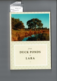 Lara RSL Sub Branch
from Duck Ponds to Lara, Booklet from Duck Ponds to Lara, 2004
Lara - Duck Ponds history and input by local population. Insight into the History of a small community.Local knowledge of Lara's History, some items are not well known, Excellant referamce.Soft back booklet a collection of of memories "From Duck Ponds to Lara." Published by the Lara Heritage Festival Inc 2004. Edited by Mary Budd, Caroline Delaney, and John Grainger. Contributions of short stories to the project have come from local residents. Booklet also came with a fold-up heritage map of Lara printed on both sides. The booklet is tagged for the names of contributors who are members of Lara R. S. L. Front of the Booklet is half covered by a photograph of Lara Creek and environes. Booklet also came with a fold-up heritage map of Lara printed on both sides.duck ponds, lara -
 Ringwood and District Historical Society
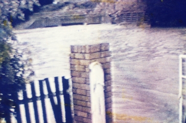
Photograph, Ringwood Bowling Club- Flooding of greens, 1989
Colour photographPhotograph was taken off the video shots taken by Jack Shandley. The flooding occurred on 10th April, 1989, when four inches of rain fell in 1½ hours. Photograph shows the height of the water in relation to the top of the Mullum Creek viaduct. -
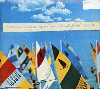 Ringwood and District Historical Society
Album, Ringwood Bowls Club- Miscellaneous photographs of Club personalities and events, 1983, 1984, 1985
Coloured photographs(61)Photographs include: Luncheon at Rembrandt, May 1984. Visit to Coal Creek. Cup Eve, 1984. Annual Dinner, March 29th 1985. Ladies World Bowls, 1985. Smorgesboard Social Bowls 17th November 1985. Miscellaneous photographs. -
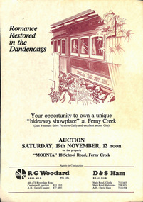 Melbourne Tram Museum
Document - Personal Papers, The Age, Keith Kings, Progress Press, Higgins Teale & Co, Herald Sun, house built using former PMTT tramcars, 1976 to 1983
Collection of Personal Papers regarding a house built using former PMTT tramcars. Comprises: 1 - Auction notice - folded A3 light card, "Moonta 18 School Road Ferny Creek" - giving details of the property, agents, floor plan and auction date of 19/11/1983. Agents R. Woodard and D&S Ham (2 copies held) 2 - Newspaper clipping from the Progress Press with a sketch and article - "Home built from trams" 3 -"Fares please for tram treat" - Herald Sun, 24/9/1983. 4 -Auction notice - 21/11/1983 - property passed in. 5 - hand written note, with plan of the trams and location map - not dated 6 - set of six hand written notes recording conversations with various people regarding a house in Ferny Creek with trams, including the Public Trustee 1976 and 1977. 7 - Auction notice for "Charrawalla" - School Road, Ferny Creek dated 7/5/1977 from The Age. Not all items numbered, See also Reg Item 1356, 1833 and 1518 for related items.trams, tramways, mmtb, pmtt, ferny creek, tramcars, melbourne, houses, sale of land -
 Eltham District Historical Society Inc
Album - Photograph, J.A. McDonald, General; Albion Street and Eltham-Yarra Glen Road, Oct. 1955
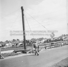
General – Country Roads Board Albion Street bridge over Moonee Ponds Creek, Brunswick West Derrick for launching beams October 1955Record of various Shire of Eltham infrastructure works undertaken during the period of 1952-1962 involving bridge and road reconstruction projects, sometimes with Eltham Shire Council Project Reference numbers quoted. It was during this period that a number of significant improvements were made to roads and new bridges constructed within the shire that remain in place as of present day (2022). In many situations, the photos provide a tangible visible record of infrastructure that existed throughout the early days of the Shire. The album was put together by or under the direction of the Shire Engineer, J.A. McDonald.infrastructure, road construction, shire of eltham, 1955-10, albion street, bridge construction, country roads board, benchmark studies, brunswick west, moonee ponds creek -
 Eltham District Historical Society Inc
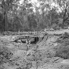
Negative - Photograph, J.A. McDonald, Heidelberg-Kinglake Road, 3 Nov. 1959
Job 56M431 Contractors Wolf and Wood Yow Yow Creek Bridge Old bridge cut Temporary bridge in use 3 November 1959Record of various Shire of Eltham infrastructure works undertaken during the period of 1952-1962 involving bridge and road reconstruction projects, sometimes with Eltham Shire Council Project Reference numbers quoted. It was during this period that a number of significant improvements were made to roads and new bridges constructed within the shire that remain in place as of present day (2022). In many situations, the photos provide a tangible visible record of infrastructure that existed throughout the early days of the Shire. The album was put together by or under the direction of the Shire Engineer, J.A. McDonald.infrastructure, shire of eltham, bridge construction, heidelberg-kinglake road, road construction, yow yow creek, 1959-11-03 -
 Eltham District Historical Society Inc
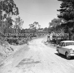
Negative - Photograph, J.A. McDonald, Heidelberg-Kinglake Road, Mar. 1960
Job 56M431 ?? ?? bridge and curve improvement to south of Yow Yow Creek March 1960 Contractor W.E. Wolf – Bridge, F.C. Wood - RoadRecord of various Shire of Eltham infrastructure works undertaken during the period of 1952-1962 involving bridge and road reconstruction projects, sometimes with Eltham Shire Council Project Reference numbers quoted. It was during this period that a number of significant improvements were made to roads and new bridges constructed within the shire that remain in place as of present day (2022). In many situations, the photos provide a tangible visible record of infrastructure that existed throughout the early days of the Shire. The album was put together by or under the direction of the Shire Engineer, J.A. McDonald.infrastructure, 1960-03, bridge construction, cherry tree road, heidelberg-kinglake road, road construction, shire of eltham -
 Eltham District Historical Society Inc
Slide - Photograph, Candlebark, Eltham Lower Park, c.Nov. 2001
Part of a slide show presentation "A Trip Down the Diamond Creek" by Russell Yeoman to the Eltham District Historical Society meeting of 14 Nov. 200135mm colour positive transparency Mount - Black and Whitecandlebark, eltham lower park, significant tree -
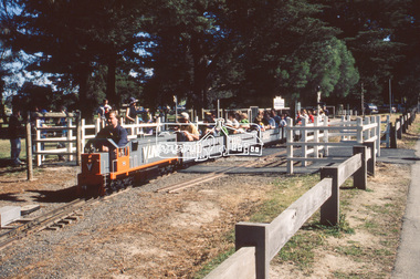 Eltham District Historical Society Inc
Slide - Photograph, Diamond Valley Railway, Eltham Lower Park, c.Nov. 2001
Part of a slide show presentation "A Trip Down the Diamond Creek" by Russell Yeoman to the Eltham District Historical Society meeting of 14 Nov. 200135mm colour positive transparency Mount - Black and Whiteeltham lower park, diamond valley railway -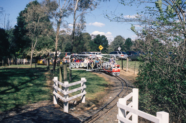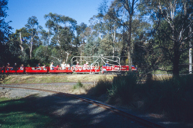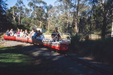
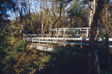 Eltham District Historical Society Inc
Slide - Photograph, Brougham Street Bridge, Eltham, c.Nov. 2001
Part of a slide show presentation "A Trip Down the Diamond Creek" by Russell Yeoman to the Eltham District Historical Society meeting of 14 Nov. 200135mm colour positive transparency Mount - Black and Whitebrougham street bridge, eltham