Showing 27534 items
matching yarra-river
-
 Mont De Lancey
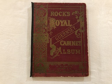
Book, Rock's Royal Guernsey. Cabinet Album
Mrs Liddy, 59 River Street, Maidstone, VictoriaAlbum containing Postcard scenes of Guernsey. Printed in Germany. Maroon cover, embossed in gold, black binding.albums, books -
 Wodonga & District Historical Society Inc
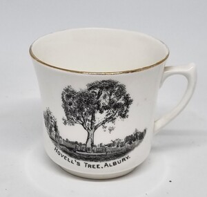
Souvenir - Cup Hovell's Tree, Albury, c1925-1950
This souvenir represents the Hovell Tree, a local historic landmark in Albury, NSW. This item is from a collection donated by descendants of John Francis Turner of Wodonga. The Hovell Tree commemorates the exploration and naming of the Hume River (now the Murray) by Hume and Hovell`s expedition of 1824. In 1824, Governor Brisbane asked Hume to join forces with an English sea captain, William Hovell, to go from Lake George to the Spencer Gulf in South Australia. The Hovell Tree, marked by William Hovell on November 17, 1824 was flanked by another tree marked by Hamilton Hume which was destroyed by fire in the 1840's. The river gum was marked by William Hovell when discovering river. Hume and Hovell travelled from the Yass area and after crossing the Murray River where Lake Hume now is, they crossed the Mitta Mitta River and proceeded to Corio Bay, Westernport.This item is representative of souvenirs produced to represent key buildings and historic landmarks in the Albury-Wodonga district.A white cup with gilt trim around the lip. It bears an image of the Hovell Tree in Albury, NSWBeneath image: "HOVELL'S TREE, ALBURY."albury souvenirs, hovell tree, hume and hovell, australian exploration -
 Upper Yarra Museum
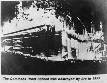
Negative Photographic Reproduction, Dammans Road school (destroyed by fire 1959) Warburton, 14.9.1983
Print in Collection of Photographs compiled by R Crowley from the History Committee Shire of Upper Yarra for UYVHS 1988Dammans Road school (destroyed by fire 1959) Warburton. Negative Black white. Scanned at 600 dpi dammans road school destroyed fire warburton 1959 -
 Upper Yarra Museum
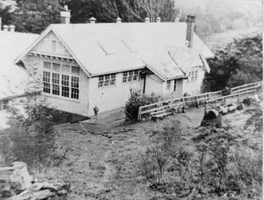
Negative Photographic Reproduction, Damman’s Rd school 1940 Warburton, 14.9.1983
Print in Collection of Photographs compiled by R Crowley from the History Committee Shire of Upper Yarra for UYVHS 1988Damman’s Rd school 1940 Warburton Negative Black white. Scanned at 600 dpidammans road school warburton 1940 -
 Eltham District Historical Society Inc
Negative - Photograph, J.A. McDonald, Eltham, Cecil Street, Sep. 1959
Stabilising junction with Eltham-Yarra Glen Road View looking west across Main Road to the railway lineRecord of various Shire of Eltham infrastructure works undertaken during the period of 1952-1962 involving bridge and road reconstruction projects, sometimes with Eltham Shire Council Project Reference numbers quoted. It was during this period that a number of significant improvements were made to roads and new bridges constructed within the shire that remain in place as of present day (2022). In many situations, the photos provide a tangible visible record of infrastructure that existed throughout the early days of the Shire. The album was put together by or under the direction of the Shire Engineer, J.A. McDonald.infrastructure, shire of eltham, road construction, cecil street, eltham, eltham-yarra glen road, main road, 1959-09 -
 Eltham District Historical Society Inc
Document, Notice of Decision to Grant a Permit; Ref: E94/306 - Subdivision of 30-34 Diosma Road; 16 November 1994, 16/11/1994
This permit was eventually overturned following community objection and the land was donated by Yarra Valley Water for use as a community reserve.The Stokes Orchard Estate collection is typical of housing developments of the late 1970s and 1980s. It was one of the earliest estates in Eltham following the nearby Woodridge Estate development.A4 document consisting of ten pagesAs notedstokes place, eltham, stokes orchard, stokes orchard estate, streets, houses, peter and carla vermey, diosma road, letter of objection, melbourne metropolitan board of works, planning application, reservoir, shire of eltham -
 Robin Boyd Foundation
Journal, Sydney Morning Herald, Art in Australia, Dec, Jan, Feb 1941-1942
Article titled "Flats on the Yarra at Toorak", about Roy Ground's Glover Court flats p. 72- 75.roy grounds, albert hanson, australian art, walsh st library -
 Uniting Church Archives - Synod of Victoria
Photograph, C1964
Rev. Graeme Gregory spoke at Yarra Bank, Voice of Methodism and his social work involved in the Department of Childcare.Gloss, black and white, head and shoulders, studio portrait of Rev. Graeme Gregory.gregory, g., methodist -
 Uniting Church Archives - Synod of Victoria
Photograph, C1975
Rev. Graeme Gregory spoke at Yarra Bank, Voice of Methodism and his social work involved in the Department of Childcare.Gloss, black and white image of Rev. Graeme Gregory in situ.gregory, g., methodist -
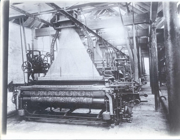 National Wool Museum
Photograph
Photograph probably for promotional purposes, of a carpet loom. Photograph was with other photographs in an envelope from Yarra Falls Mill.Photograph, black and white, of a carpet loom.textile machinery weaving, yarra falls mill david sowden & sons, weaving looms, weaving machinery, carpet, textile machinery, weaving -
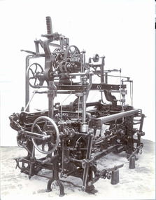 National Wool Museum
Photograph
Photograph probably for promotional purposes, of a loom No177. Photograph was with other photographs in an envelope from Yarra Falls Mill.Photograph, black and white, probably of a "David Sowden & Sons" loom No 177.177textile machinery weaving, yarra falls mill david sowden & sons, weaving looms, weaving machinery, textile machinery, weaving -
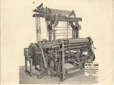 National Wool Museum
Print
Lithographic print of a "David Sowden & Sons Patent Loom No 75." Among items from Yarra Falls Mill.Lithographic print of a "David Sowden & Sons Patent Loom No 75."textile machinery weaving, yarra falls mill david sowden & sons, weaving looms, weaving machinery, textile machinery, weaving -
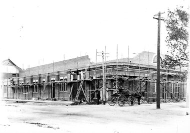 Ballarat Tramway Museum
Photograph - Geelong MESCO office, Melbourne Electric Supply Co (MESCo), c.1910-15
MESCo offices in the process of construction. Sewerage contractor's buggy passing by. SW corner of Yarra and Corio Sts., Geelong.Yields information on MESCo Geelong building under construction. Black and white print on paperPlate 2-6 written in ink on the back of the photographmesco geelong, building construction, sewerage buggy -
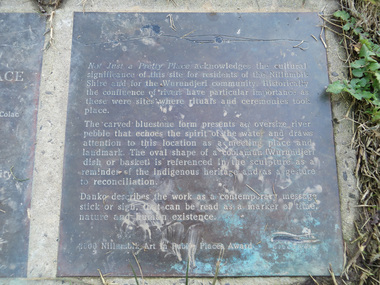 Eltham District Historical Society Inc
Photograph, Liz Pidgeon, Heritage Excursion; Eltham Lower Park Walk and Talk, 1 July 2017, 1 July 2017
Transcription of plaque: Not Just a Pretty Place acknowledges the cultural significance of this site for residnets of the Nillumbik Shire and for the Wurundjeri community. Historically the confluence of rivers have particular importance as these were sites where rituals and ceremonies took place. The carved bluestone form presents an oversize river pebble that echoes the spirit of the water and draws attention to this location as a meeting place and landmark. The oval shape of a coolamun (Wurundjeri dish or basket) is referenced in the sculpture as a reminder of the indigenous heritage and as a gesture to reconciliation Danko describes the work as a contemporary message stick or sign, that can be read as a merker of time, nature and human existance. 2000 Nillumbik Art in Public Places Award. Heritage Excursion - Saturday 1st July - Eltham Lower Park - Walk and Talk Eltham Lower Park has played an important part in the history of our area since the early days of European settlement when it was used by local residents as an informal racecourse. Prior to that its location at the junction of the Diamond Creek and the Yarra River made it an important meeting place for the Wurundjeri people. The park combines formal elements and sporting facilities with remnant bushland that is of environmental significance. It is home to sporting and horse riding clubs, popular play spaces and the Diamond Valley Miniature Railway, which attracts large numbers of visitors. The park will be the venue for our July excursion which will comprise a walk of about 3.5 km around the park and adjacent areas. Along the way we will discuss the history and natural history of the area. The path along the creek and the river provides a pleasant and scenic walk. This walk on Saturday 1st July is about 3.5 km in length and will take 2 to 2.5 hours. It will start at 2pm at the Main Road car park at the front of the park. (Melway ref 21 H 10). From Newsletter No., 234, June 2017 Born Digitalelection day, heritage excursion, activities, eltham district historical society, eltham lower park, not just a pretty place, public art, plaque -
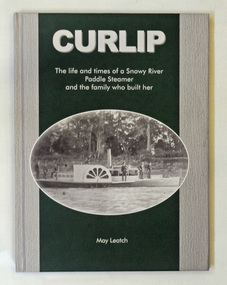 Orbost & District Historical Society
book, Curlip, November 2008
This book was written at the same time as the replica of the PS Curlip was being built in Orbost. The great grandson of Samuel Richardson is Gil Richardson who lives in Bete Bolong just outside Orbost. Gil and Heather Richards presented the author, May Leatch with a box of old diaries written by Sam Richardson and Sam's sons, Alan and Frank. Using these as the basis of the story, May wrote the full story of the Curlip and the Richardson family.This book about a local icon and a local family was written in Orbost by a local historian.A green and grey covered book titled, CURLIP The life and times of a Snowy River Paddle Steamer and the family who built her. On the front cover is a black and white photograph of the PS Curlip taken shortly after its launch in 1890. On the back cover is a black and white photograph of phragmites on the Snowy River floodplain. The book traces the history of the Richardson family from Godalming, Surrey, England to Orbost, East Gippsland, Victoria in Australia. It contains b/w photographs, diary extracts and newspaper extracts. The book was written by May Leatch.p.s.curlip paddle-steamers orbost richardson-family richardson-samuel -
![Photograph - Digital image, Pioneer Children's Cemetery [from above], 1985_](/media/collectors/4f729f5697f83e03086015b8/items/54bb56202162f10ca8d79013/item-media/54bb56452162f10ca8d79127/item-fit-380x285.jpg) Greensborough Historical Society
Greensborough Historical SocietyPhotograph - Digital image, Pioneer Children's Cemetery [from above], 1985_
The unmarked graves of the children of two Greensborough pioneer families lie in a private cemetery on the Plenty River. Burials occurred between 1848 and 1860. This photograph is taken from above the cemetery site looking towards the Plenty River with the Maroondah Aqueduct in the background.An important historical site in Greensborough.Digital copy of colour photograph.pioneer childrens cemetery, plenty river, maroondah aqueduct, partington, whatmough -
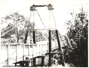 Kew Historical Society Inc
Photograph - Photograph (copy), Kanes Bridge, Studley Park, 195-1955
In 1928 a footbridge was erected to link Kew with the public golf course across the Yarra. The total cost of construction came to 250 pounds and the bridge became known as Kane's Bridge. During the 1934 floods the bridge was washed downstream, and was subsequently rebuilt. The present form of the bridge resembles the earlier bridge which crossed from the Yarra Bend Asylum to Kew, further upstream. (VHD)This work forms part of the collection assembled by the historian Dorothy Rogers, that was donated to the Kew Historical Society by her son John Rogers in 2015. The manuscripts, photographs, maps, and documents were sourced by her from both family and local collections or produced as references for her print publications. Many were directly used by Rogers in writing ‘Lovely Old Homes of Kew’ (1961) and 'A History of Kew' (1973), or the numerous articles on local history that she produced for suburban newspapers. Most of the photographs in the collection include detailed annotations in her hand. The Rogers Collection provides a comprehensive insight into the working habits of a historian in the 1960s and 1970s. Together it forms the largest privately-donated collection within the archives of the Kew Historical Society.A photographic copy of an older photograph of Kanes Bridge."Kanes Bridge"kanes bridge, yarra river, bridges - kew (vic.) -
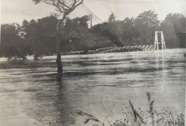 Kew Historical Society Inc
Photograph - Kane's Bridge destroyed by the 1934 Flood, 1934
In 1928 a footbridge was erected to link Kew with the public golf course across the Yarra. The total cost of construction came to 250 pounds and the bridge became known as Kane's Bridge. During the 1934 floods the bridge was washed downstream, and was subsequently rebuilt. The present form of the bridge resembles the earlier bridge which crossed from the Yarra Bend Asylum to Kew, further upstream. (VHD)Black and white positive print (identical to 2021.70 but with a different annotation) showing the destruction of Kane's Bridge in the floods of 1934. The Kodak paper would indicate a 1950s reprinting.Annotation verso: "Kane's Bridge in 1934 flood / Dec. 1934.kane's bridge, river yarra, yarra valley, 1934 floods -
 Ballan Shire Historical Society
Map - Map. Shire of Ballan, Shire of Ballan
This is a fairly comprehensive map of the former Shire of Ballan which is now amalgamated into the Shire of Moorabool.A black and white map of the Shire of Ballan showing major roads, rivers, towns, settlements, State parks and forests and land subdivisions. It appears to be a copy of the original as no dates or maker or printer appear on the map. There is a scale of 2 miles to 1 inch.gordon, ballan, bungal, kerrit bareet, borhoneyghurk, bungeeltap, ballark, yaloak, gorong, beremboke, wallace, ingliston, hunterston, millbrook, bradshaw, myrniong, blackwood, moorarbool, greendale, bayup, trentham, bullarto, korweinguboora, glenlyon, bolwarra -
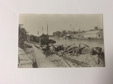 Port of Echuca
Black and white photograph, Approx 1980
Scene depicted is believed to have been the Euston Lock. It shows various pieces of equipment in the foreground , with a pontoon names Bream on the left bank with a paddle steamer, sheds and cranes in the distance on the right hand side of the photograph. Original photograph from the Price collection. Historically and socially significant photograph depicting early 1920's life on the Murray river.Black and white photograph of river scene depicting , by the left bank a pontoon "Bream" and by the right bank a steamboat behind a shelter construction. There are various cranes on the right bank. Copy of an original photograph taken in the 1920s believed to at Euston Lock, N.S.W.In pencil on back: Price / believed to be Euston Lock.riverboats, paddle steamers, price collection -
 Bendigo Military Museum
Book, The Edge of the Sword, 1955
The Edge of the Sword - This book is the story of the Gloucestershire Regiment in the Imjin Battle and in captivity.Hard cover, red colour buckram, gold print own spine. 286 pages cut plain. Illustrated black and white photographs. End paper illustrated with map "Battle of the Imjin River" and "Routes followed by the author after capture"books, military history -
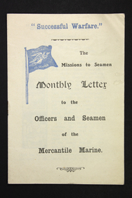 Mission to Seafarers Victoria
Flyer - Newsletter, Mission to Seafarers, "Successful Warfare" - The Missions to Seamen Monthly Letter to the Officers and Seamen of the Mercantile Marine, 1914-1918
The newsletter was published to address the Mercantile Marine primarily officers in the service. This is the number 19. The term "Merchant Navy" was coined in 1919 by King George V. So this foyer predates 1919.An unusual example of newsletter circulated by the Missions to Seamen (UK) during WW1. The aim may well have been to boost morale but clearly targeting Merchant mariners.Small paper and ink (2 colours, black and blue) 4 page stapled paper pamphlet/booklet. First page features some small black and white printed hand drawn graphics of a river mouth and a decorative angel or female. ww 1, mercantile marine service, mercantile marine, ww1, first world war, great war -
 Kiewa Valley Historical Society
Photos - Kiewa Hydro Electric Scheme - Dartmouth, Official S.E.C.V. photos
Dartmouth Dam was built on the Mitta Mitta River in the 1970s. It is the highest dam in Australia (2022). It is the largest storage in Victoria (2022). It was built primarly for irrigation and urban use. The power station has the largest hydro-electric generator in Victoria (2022). -
 Bendigo Historical Society Inc.
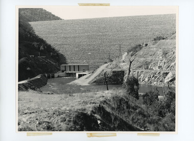
Slide - MOUAT CRAWFORD COLLECTION: FARMING IN THE WIMMERA, c1962
Mouat Collection - Farming in the Wimmera. Slide shows; State Rivers and Water Supply Commission. Eppalock Project. Cross section of dam along tunnel. Markings: Plan of Eppalock Res. Near Bendigo SEP 62M. Used as a teaching aid.kodak -
 Bendigo Historical Society Inc.
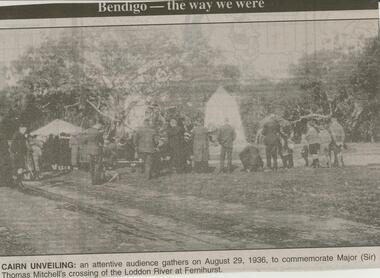
Newspaper - JENNY FOLEY COLLECTION: CAIRN UNVEILING
Bendigo Advertiser ''The way we were'' from Monday, March 12, 2001. Cairn unveiling: an attentive audience gathers on August 29, 1936, to commemorate Major (Sir) Thomas Mitchell's crossing of the Loddon River at Fernihurst. The clip is in a folder.newspaper, bendigo advertiser, the way we were -
 Bendigo Historical Society Inc.
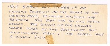
Document - BOTTLE FROM MOORNA STATION
White card with handwritten note: 'This Bottle was picked up on Moorna Station on the banks of the Murray River, between Mildura and Renmark. The spot was an old hotel cellar. The bricks of the cellar were made by the prisoners at Wentworth Gaol. The hotel was a coach Stop.document, bottle from moorna station, wentworth gaol. -
Bendigo Historical Society Inc.
Map - ROCHESTER WEST : COUNTY OF BENDIGO, 30-10-12
Map. Rochester West, County of Bendigo, Ballendella, Giggorra, Township of Rochester. Campaspe River. Photo-lithographed at the Department of Lands and Survey, Melbourne, by W.J. Butson 30-10-12. Price 1/-. (number 22 in map cupboard 1)W.J. Butson, Government Printer.map, bendigo, rochester west -
 National Vietnam Veterans Museum (NVVM)
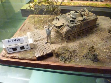
Model - Diorama
M113 APC Stopped on track near simple sapling river crossing. Twp Crew are in attendance, all hatches are open, soldier sitting in top hatch is holding a can of coke. Soldier at front of APC appears to be stretching, taking a break.m113, armoured personnel carrier, diorama, at rest -
 Bendigo Historical Society Inc.
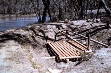
Slide - PETER ELLIS COLLECTION: SLIDE, May 1970 - Jan 1972
Coloured slide transparency. Image is of a bush area. There is some machinery set into the ground in the foreground and some water from either a river or dam can be seen to the right. The words, Ruedin's Euc Oil Condenser are handwritten across the bottom border.Kodachrome Transparencyslide, bendigo, bendigo institute of technology -
Bendigo Historical Society Inc.
Photograph - HARRY BIGGS COLLECTION: BOTANICAL GARDEN BEACH, BRISBANE
Photograph. Harry Biggs Collection. A very small black & white photo of Botanical Garden Beach, Brisbane River. The photo is taken from what we now call Southbank. 5 boats can be seen in the foreground & the city in the background.place, land, public park, harry biggs collection, botanical garden beach, brisbane