Showing 1211 items
matching australian rivers
-
 Flagstaff Hill Maritime Museum and Village
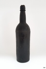
Container - Bottle, 1840s to 1878
This handmade black glass bottle was recovered between the late 1960s to early 1970s from the wreck of the sailing ship Loch Ard. The ship was wrecked in 1878 and its remains are located at Mutton Bird Island, near Port Campbell, Victoria and bottles of liquor were listed as part of the Loch Ard’s cargo. All glass is made from silica, which is found in quartz sand. The naturally occurring sand has impurities, such as iron, that determine the colour of the glass. Residual iron leads to green or amber-coloured glass and carbon in the sand makes that glass appear as ‘black’. A strong light behind the glass will show its colour as dark green or dark amber. This handmade bottle appears to have been made in a two-piece dip mould, with the molten glass blown into a seamless shoulder-height mould to give the body a uniform symmetrical shape and size. After the body is blown, the glass blower continues blowing free-form (without the mould) to form the shoulder and neck, then the base is pushed up with a tool, and the finish for the mouth is added with his tools. The dip mould gives the body a slightly textured surface, with the free-blown shoulders and neck being smoother and shinier. There is usually a line around the shoulder where the mould of the body meets the shoulder, and a lump or mark in the centre of the base, called a pontil mark, where the push-up tool was removed. The ship Loch Ard was built on the River Clyde in Scotland in 1873 for the prestigious Loch Line of colonial clipper ships, designed for the Australian run. It sailed from England on 1 March 1878 carrying 37 crew, 17 passengers and a diverse general cargo ranging from luxury items to bulk railway iron. On 1 June 1878, emerging from the fog and hearing too late the sound of breakers against the tall limestone cliffs, the vessel struck the southern foot of Mutton Bird Island and sank in 23 metres of water. Of the fifty-four people on board only two survived, one young male crewman, Tom Pearce, and one young female passenger, Eva Carmichael. This bottle is historically significant as an example of liquor bottles imported into to Colonial Victoria in the mid-1800s to early-1900s. The bottle is also significant for being part of Flagstaff Hill’s collection of artefacts from the Loch Ard, which is significant for being one of the largest collections of artefacts from this shipwreck in Victoria. The collection is significant for its association with the shipwreck, which is on the Victorian Heritage Register (VHR S417. The collection has additional significance because of the relationship between the objects, as together they have a high potential to interpret the story of the Loch Ard. The Loch Ard collection is archaeologically significant as the remains of a large international passenger and cargo ship. The Loch Ard collection is historically significant for representing aspects of Victoria’s shipping history and its potential to interpret sub-theme 1.5 of Victoria’s Framework of Historical Themes (living with natural processes). The shipwreck is one of the worst, and best-known, shipwrecks in Victoria’s history.Bottle, black glass wine bottle with contents. Glass has ripples, crease lines and side seams. The mouth has a seal in place. The applied lip is wide. The base has been pushed-up base and has a pontil mark. Handmade with a ridge in the body around the base of the shoulder. The bottle has a white sticker.flagstaff hill, warrnambool, flagstaff hill maritime museum, maritime museum, shipwreck coast, flagstaff hill maritime village, great ocean road, shipwreck artefact, loch ard, mutton bird island, eva carmichael, tom pearce, john chance, bottle, antique bottle, bulge neck bottle, handmade, dip mould, mouth blown, pontil base, blown bottle, liquor bottle, ale bottle, black glass, black bottle -
 Flagstaff Hill Maritime Museum and Village
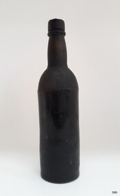
Container - Bottle, 1840s to 1878
This handmade black glass bottle was recovered between the late 1960s to early 1970s from the wreck of the sailing ship Loch Ard. The ship was wrecked in 1878 and its remains are located at Mutton Bird Island, near Port Campbell, Victoria and bottles of liquor were listed as part of the Loch Ard’s cargo. All glass is made from silica, which is found in quartz sand. The naturally occurring sand has impurities, such as iron, that determine the colour of the glass. Residual iron leads to green or amber-coloured glass and carbon in the sand makes that glass appear as ‘black’. A strong light behind the glass will show its colour as dark green or dark amber. This handmade bottle appears to have been made in a two-piece dip mould, with the molten glass blown into a seamless shoulder-height mould to give the body a uniform symmetrical shape and size. After the body is blown, the glass blower continues blowing free-form (without the mould) to form the shoulder and neck, then the base is pushed up with a tool, and the finish for the mouth is added with his tools. The dip mould gives the body a slightly textured surface, with the free-blown shoulders and neck being smoother and shinier. There is usually a line around the shoulder where the mould of the body meets the shoulder, and a lump or mark in the centre of the base, called a pontil mark, where the push-up tool was removed. The ship Loch Ard was built on the River Clyde in Scotland in 1873 for the prestigious Loch Line of colonial clipper ships, designed for the Australian run. It sailed from England on 1 March 1878 carrying 37 crew, 17 passengers and a diverse general cargo ranging from luxury items to bulk railway iron. On 1 June 1878, emerging from the fog and hearing too late the sound of breakers against the tall limestone cliffs, the vessel struck the southern foot of Mutton Bird Island and sank in 23 metres of water. Of the fifty-four people on board only two survived, one young male crewman, Tom Pearce, and one young female passenger, Eva Carmichael. This bottle is historically significant as an example of liquor bottles imported into to Colonial Victoria in the mid-1800s to early-1900s. The bottle is also significant for being part of Flagstaff Hill’s collection of artefacts from the Loch Ard, which is significant for being one of the largest collections of artefacts from this shipwreck in Victoria. The collection is significant for its association with the shipwreck, which is on the Victorian Heritage Register (VHR S417. The collection has additional significance because of the relationship between the objects, as together they have a high potential to interpret the story of the Loch Ard. The Loch Ard collection is archaeologically significant as the remains of a large international passenger and cargo ship. The Loch Ard collection is historically significant for representing aspects of Victoria’s shipping history and its potential to interpret sub-theme 1.5 of Victoria’s Framework of Historical Themes (living with natural processes). The shipwreck is one of the worst, and best-known, shipwrecks in Victoria’s history.Bottle, black glass wine bottle with contents. Glass has ripples, and crease lines and the neck has side seams. The mouth has a seal, the top of which comes away from the rest of the seal. The applied lip is wide. The base has been pushed-up base and has a pontil mark. Handmade with a ridge in the body around the base of the shoulder. The contents have no colour or odour. The bottle has a white sticker.flagstaff hill, warrnambool, flagstaff hill maritime museum, maritime museum, shipwreck coast, flagstaff hill maritime village, great ocean road, shipwreck artefact, loch ard, mutton bird island, eva carmichael, tom pearce, john chance, bottle, antique bottle, bulge neck bottle, handmade, dip mould, mouth blown, pontil base, blown bottle, liquor bottle, ale bottle, black glass, black bottle -
 Marysville & District Historical Society
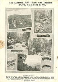
Ephemera (Item) - Magaine page, Government Tourist Bureau, See Australia First-Start with Victoria-Travel in Comfort by Rail, Unknown
A page from a magazine advertising Marysville and some local beauty spots to visit. This magazine was published when it was still possible to travel to Healesville by rail. From Healesville you would travel by car to Marysville via the Black's Spur, as it was known in those days.A page from a magazine advertising Marysville and some local beauty spots to visit.marysville, victoria, glover's walk, taggerty river, nicholl's lookout, government tourist bureau, healesville, black's spur, black spur -
 Marysville & District Historical Society
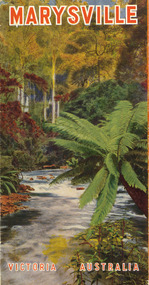
Ephemera (Item) - Tourist brochure, Victorian Railways, Marysville Victoria Australia, 01-1941
A tourist information brochure that was issued by the Publicity and Tourist Services of Victorian Railways, in January, 1941, to promote Marysville and the surrounding district.A tourist information brochure that was issued by the Publicity and Tourist Services of Victorian Railways, in January, 1941, to promote Marysville and the surrounding district.marysville, victoria, cumberland valley, messmate, buxton, taggerty river, acheron way, black's spur, cement creek, keppel falls, steavenson falls, cumberland falls, narbethong, st fillan, taggerty valley, wade's lookout, mount gordon, nicholls lookout, lake mountain, victorian government tourist bureau, victorian railways -
 Marysville & District Historical Society
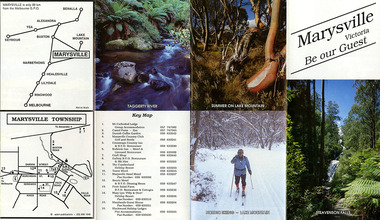
Booklet (Item) - Leisure guide, Michael Chesire & Associates Pty. Ltd, MARYSVILLE & DISTRICT LEISURE GUIDE-AUTUMN/WINTER, 1986, 1986
A free leisure guide to Marysville and the surrounding district published for Autumn and Winter, 1986. This was produced by Michael Cheshire as a free publication to promote tourism in Marysville and the surrounding district. It includes maps of the Big River Valley, Cumberland Valley, Lady Talbot Forest Drive, the Marysville area, and the township of Marysville. It was released in the autumn of 1986 and was sponsored by the Marysville Tourist & Progress Association. The Association was formed in November 1907 to promote tourism within the area. This included the physical creation of signage, parklands, roads, and walks to various attractions. A free leisure guide to Marysville and the surrounding district published for Autumn and Winter, 1986.marysville, victoria, australia, leisure guide, michael cheshire & associates pty ltd, marysville golf club, blackwood lodges, sir colin mackenzie fauna park, lake eildon, fraser national park, yarra valley wineries, marysville coach tours, kooringa, marylands guest house, lady talbot forest drive, wishing well, taggerty river recreation area, athols abbey, phantom falls, keppel falls, the beeches walking track, marylyn guest house, kufstein inn motel, the cumberland, marysville tourist & progress association, marysville newsagency & general store, crossways restaurant & motel, beauty spot walk, tree fern gully walk, michaeldene track, keppel track, woods lookout track, marysville hotel motel, lake mountain ski hire, marysville recreation and fun park, mytanta horseback safaris, upper big river valley, the big culvert, marysville mountain view horse hire, maryton park, amber view holiday lodges, cathedral restaurant, the top shop, tower motel, menzes garage, beauty spot nursery, marysville ski hire, lake mountain ski school, faraway forest, scenic motel, buxton trout farm, marysville hardware, timbertop steakhouse, marysville trout farm, healesville sanctuary, buxton hotel motel, nanda binya lodge, buxton antique and furniture mart, the black spur inn hotel, alexandra, lake mountain, geoffrey pope & associates -
 Marysville & District Historical Society
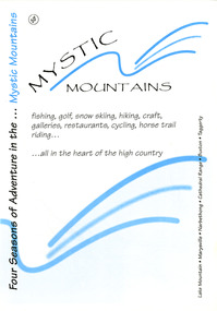
Ephemera (Item) - Visitor information pack, Four Seasons of Adventure in the Mystic Mountains, Unknown
A visitor information pack on Marysville and the surrounding district.A visitor information pack on Marysville and the surrounding district.marysville, victoria, australia, visitor information pack, lake mountain, narbethong, cathedral range, buxton, taggerty, mystic mountains, beauty spot walk, tree fern gully walk, michaeldene track, keppel track, woods lookout track, lady talbot forest drive, wishing well, taggerty river picnic area, taggerty river, phantom falls, keppel falls, the beeches walking track, mount sugarloaf, department of conservation & environment victoria -
 Marysville & District Historical Society
Ephemera (Item) - Tourist Guide, Marysville Tourist Association, Marysville Victoria Be our Guest, Unknown
A fold out tourist guide to Marysville and the surrounding district. This map was produced by the Marysville Tourist Association.A fold out tourist guide to Marysville and the surrounding district.marysville, victoria, australia, tourist guide, steavenson falls, mt cathedral lodge, camelot camel farm, danish coffee garden, marysville country club, crossways country inn, kufstein inn, marysville craft shop, gallery restaurant, the cumberland, tower motel, marysville hotel, scenic motel, fruit salad farm, marylyn guest house, marylands guest house, blackwood lodges, taggerty river, lake mountain -
 Marysville & District Historical Society
Book - Hardcover book, J.W. Lindt Master Photographer, 1985
A book of photographs taken by John William Lindt of locations and scenery throughout the world.A book of photographs taken by John William Lindt of locations and scenery throughout the world. John William Lindt (1845–1926), was a German-born Australian landscape and ethnographic photographer, early photojournalist, and portraitist. John Lindt was responsible for a folio of photographs of the Fernshaw and Watts River area and he sold over 25,000 images of the Black Spur from his original negatives. In 1895 he was able to purchase land on the North East side of the Black Spur and subsequently built his home and guesthouse "The Hermitage" from where he continued his photographic career. In 1913 he collaborated with Nicholas Caire to produce a tourist booklet on the area. In 1925 the Argus reported that Lindt "continues to produce remarkable and most artistic pictures of the beauties of mountain landscape. He is not a believer in the blurred effects favoured by many ... instead he is a master of detail." Aged 81 Lindt died of heart failure during disastrous bushfires on 19 February 1926 at the Hermitage. He was survived by his wife Catherine who continued to run ‘The Hermitage’ guest house before she retired to the city.Hardcover. Front cover photograph-Log Bridge at the Hermitage c1910photography, artistic, john william lindt, la trobe collection, shar jones -
 Marysville & District Historical Society
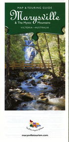
Map (Item) - Map and touring guide, Murrindindi Regional Tourism Association Inc, Marysville & The Mystic Mountains VICTORIA-AUSTRALIA, 08-2002
A fold out map and touring guide of Marysville and the surrounding district published in 2002 by Murrindindi Regional Tourism Association Inc.A fold out map and touring guide of Marysville and the surrounding district published in 2002 by Murrindindi Regional Tourism Association Inc.marysville, victoria, australia, map and touring guide, mystic mountains tourism, the beeches rainforest walk, lake mountain, cambarville, cathedral range state park, the cumberland, abbey green b&b cottages, anastasia fairytale cottage, ashlar cottage b&b, somerled mountain retreat, baree mudbrick cottages, blackwood cottages, camellia cottage, cathedral view b&b, cottage riverside, crossways country inn, dalrymples guest cottages, esa country ministries, hillcrest, keppels hotel motel, kerami house, lomatia lodge, lyell guest cottages, marylands country house, marysville caravan park, marysville holiday cottages, maryton park, melina cottage, moondai farm b&b, mountain lodge marysville, mount cathedral lodge, mystic mountains holiday cottages, nanda binya lodge, rendezvous on murchison, scenic b&b, the hermitage, tower motel, waratah house, willowbank at taggerty, woodlands of narbethong, keppels, lake mountain resort cafe, lanterns at willowbank, mantirri blueberry farm, marysville country bakery, the old woolshed cafe, clearstream olives, uncle fred & aunty val's old style lolly shop, acheron valley alpacas country store & gallery, bruno's art and sculpture garden, country touch, things of sand & stone, willowbank gallery, marysville auto & hardware, marysville newsagency & general store, marysville visitor information centre, narbethong visitor information centre, gallipoli park, keppels lookout, lady talbot drive, steavenson falls, steavenson river, taggerty river, acheron river, black spur trail riding centre, buxton trout farm, lake mountain resort ski hire, lake mountain ski school, marysville district country club, marysville ski centre, narbethong ski hire, rubicon horse riding, country touch tours, murrindindi regional tourism association inc -
 Marysville & District Historical Society
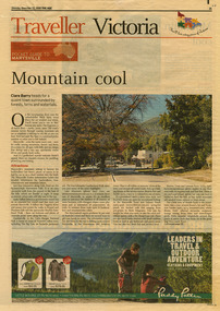
Newspaper (Item) - Newspaper article, The Age, POCKET GUIDE TO MARYSVILLE, 22-11-2008
A newspaper article on Marysville, its local attractions, places to shop and dine, where to stay and ways of traveling to Marysville. This article was published in The Age on Saturday, November 22, 2008.A newspaper article on Marysville, its local attractions, places to shop and dine, where to stay and ways of traveling to Marysville.marysville, victoria, australia, the age, black spur, marysville visitor information centre, steavenson falls, lady talbot drive, taggerty river, keppel falls, phantom falls, beeches rainforest walk, cambarville, yarra ranges national park, the big tree, cumberland walk, lake mountain, steavenson river, acheron river, buxton bait and tackle, marysville trout and salmon ponds, buxton trout and salmon farm, bruno's art and sculpture garden, villa day spa, cathedral view natural therapies, marysville massage, murchison street, village walk, uncle fred & aunty val's old style lolly shop, country touch gallery, manical mechanicals, hidden talent craft gallery, carmyle farm boutique, marysville community market, marysville patisserie, marysville country bakery, fraga's cafe restaurant, terracotta room, marylands country house, the cumberland, mantirri blueberry farm, narbethong, marysville farmers market, the black spur inn, allawah country cottages, barree mud brick cottages -
 Marysville & District Historical Society
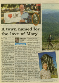
Newspaper (Item) - Newspaper article, Geoffrey Wright, A town named for the love of Mary, Unknown
A digital copy of a newspaper article on Marysville and some of its history as well as some local identities. This article was written by Geoffrey Wright for THE WRIGHT ROAD.A digital copy of a newspaper article on Marysville and some of its history as well as some local identities.marysville, victoria, australia, geoffrey wright, lake mountain, wood's point, gaffney's creek, goulburn river, john steavenson, mary martha murphy, yarra track, barton bros store, j l gould sawmill -
 Marysville & District Historical Society
Ephemera (Item) - Information brochure, Artworkz Tourism, MARYSVILLE TOWNSHIP, 11-2020
An information brochure on the township of Marysville in Victoria. This brochure was produced by Artworkz Tourism in November 2020.An information brochure on the township of Marysville in Victoria.Disclaimer: The authors have taken care to ensure this/ publication is correct, though please be aware that/ errors and omissions do occur.marysville, victoria, australia, information brochure, artworkz tourism, 2009 black saturday bushfires, bruno's sculpture garden, steavenson falls, gallipoli lake, keppel falls, lady talbot drive, cora lynn falls, cambarville walk, phantom falls, taggerty river visitor area, meeting of the waters, the beeches, cambarville day visitor area, the big tree, keppel hut, keppel lookout, mount gordon, marysville golf course, jock's lookout, gallipoli park, yellow dog day visitor area -
Marysville & District Historical Society
Ephemera (Item) - Information brochure, Artworkz Tourism, MARYSVILLE THINGS TO DO AROUND MARYSVILLE, 27-01-2018
An information brochure on things to do around Marysville in Victoria.An information brochure on things to do around Marysville in Victoria.Disclaimer: The authors have taken care to ensure this/ publication is correct, though please be aware that/ errors and omissions do occur.marysville, victoria, australia, information brochure, gallipoli park lake, gallipoli lake, steavenson falls, steavenson river, bruno's art and sculpture garden, fernshaw park, buxton recreation reserve, taggerty river areas, anderson mill camping area, cooks mill camping area, neds gully camping area, keppel creek day area, beauty spot nature walk, gilbert gully nature walk, michaeldene track, cathedral range, the beeches walk, tree fern gully walk, crystal journey, marysville market, lake mountain ski resort, marysville golf club, marysville public outdoor swimming pool, buxton trout & salmon farm, keppel's lookout, jock's lookout, mount gordon, armstrong lookout, keppel falls, phantom falls, cora lynn falls, meeting of the waters, st ronan's well, preiffer falls, camberville historical township, keppels hut, the big culvert, the big tree, marysville historical society -
Marysville & District Historical Society
Ephemera (Item) - Information brochure, Artworkz Tourism, MARYSVILLE-MARYSVILLE ATTRACTIONS, 23-11-2014
An information brochure on various attractions to be visited in an around Marysville. This brochure was produced by Artworkz Tourism in November 2014.An information brochure on various attractions to be visited in an around Marysville.Disclaimer: The authors have taken care to ensure this/ publication is correct, though please be aware that/ errors and omissions do occur.marysville, victoria, australia, information brochure, bruno's sculpture garden, steavenson falls, gallipoli lake, keppel falls, cora lynn falls, phantom falls, taggerty river visitor area, the beeches, meeting of the waters, cambarville day visitor area, the big tree, the big culvert, keppels hut, keppel lookout, mount gordon, marysville golf course, trestle bridge, marysville caravan park, marysville swimming pool, jock's lookout, yellow dog day visitor area, artworkz tourism -
Marysville & District Historical Society
Ephemera (Item) - Information brochure, Artworkz Tourism, MARYSVILLE-REFLECTIVE GARDENS & KIN PLAYSPACE, 04-01-2020
An information brochure on reflective gardens and play spaces in and around Marysville. This brochure was produced by Artworkz Tourism in January 2020.An information brochure on reflective gardens and play spaces in and around Marysville.Disclaimer: The authors have taken care to ensure this/ publication is correct, though please be aware that/ errors and omissions do occur.marysville, victoria, australia, information brochure, bruno torfs, steavenson river, gallipoli lake, gallipoli park, marysville visitor information centre, artworkz tourism -
Marysville & District Historical Society
Book (Item) - Ebook, Artworkz Tourism, Marysville Gallery, 05-2012
An ebook on various attractions to be visited in and around Marysville. This ebook was published by Artworkz Tourism in May 2012.An ebook on various attractions to be visited in and around Marysville.cambarville, cambarville waterfalls, cathedral state park, cora lynn falls, historic trestle bridge, jock's lookout, lady talbot drive, keppel falls, keppel hut, keppel lookout, gallipoli park, phantom falls, steavenson falls, taggerty river, taggerty cascades, the beeches rainforest walk, the big culvert, the big tree, meeting of the waters marysville, meeting of the waters buxton, marysville, victoria, australia, ebook -
 Marysville & District Historical Society
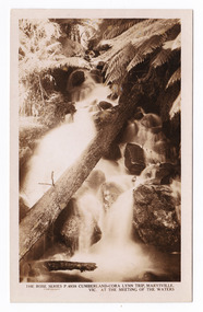
Postcard (item) - Black and white postcard, Rose Stereograph Company, Cumberland-Cora Lynn Trip, Marysville, Vic. At the Meeting of the Waters, 1913-1967
A postcard in a series produced by the Rose Stereograph Company in Victoria, Australia as a souvenir of Marysville.A black and white photograph of the Cora-Lynn waterfall at the Meeting of the Waters near the Cumberland Creek. The Whitehouse Creek joins the Taggerty River at the Meeting of the Waters which is near The Beeches Rainforest Walk. The ancient rainforest features groves of Myrtle Beech trees (Nothofagus cunninghamii) with many trees over 300 years old. POST CARD The "Rose" Series/ De Luxe A Real Photograph/ Produced in Australia Published by the Rose Stereograph Co.,/ Armadale, Victoria.cora lynn falls, waterfalls, cumberland valley, cumberland creek, marysville, victoria, p. 4938, rose series postcard, postcard, souvenir, the beeches, nothofagus cunninghamii, whitehouse creek, taggerty river -
 Marysville & District Historical Society
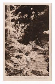
Postcard (item) - Black and white postcard, Rose Stereograph Company, At the Meeting of the Waters, Cumberland-Cora Lynn Trip, Marysville, Vic, 1913-1967
A postcard in a series produced by the Rose Stereograph Company in Victoria, Australia as a souvenir of Marysville.A black and white photograph taken at the Meeting of the Waters near the Cumberland Creek. The Whitehouse Creek joins the Taggerty River at the Meeting of the Waters which is near The Beeches Rainforest Walk. The ancient rainforest features groves of Myrtle Beech trees (Nothofagus cunninghamii) with many trees over 300 years old. POST CARD The "Rose" Series/ De Luxe A Real Photograph/ Produced in Australia Published by the Rose Stereograph Co./ Armadale, Victoria. With all Good Wishes/ for a Merry Xmas & a/ Happy New Year/ From/ The Robertson & James families/ Maude James Mrs De La Rue/ Russell St/ Northcotecora lynn falls, waterfalls, cumberland valley, cumberland creek, marysville, victoria, rose series postcard, postcard, souvenir, the beeches, nothofagus cunninghamii, whitehouse creek, taggerty river, p. 4977 -
 Marysville & District Historical Society
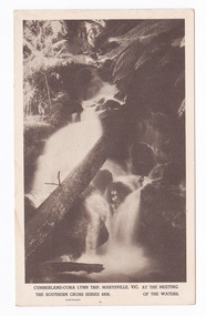
Postcard (item) - Black and white postcard, Rose Stereograph Company, Cumberland-Cora Lynn Trip, Marysville, Vic. At the Meeting of the Waters, 1913-1967
A postcard in a series produced by the Rose Stereograph Company in Victoria, Australia as a souvenir of Marysville.A black and white photograph of the Cora-Lynn waterfall at the Meeting of the Waters near the Cumberland Creek. The Whitehouse Creek joins the Taggerty River at the Meeting of the Waters which is near The Beeches Rainforest Walk. The ancient rainforest features groves of Myrtle Beech trees (Nothofagus cunninghamii) with many trees over 300 years old. POST CARD Correspondence Addresscora lynn falls, waterfalls, cumberland valley, cumberland creek, marysville, victoria, postcard, souvenir, the beeches, nothofagus cunninghamii, whitehouse creek, taggerty river, southern cross series, 4938 -
Marysville & District Historical Society
Article (item) - Museum Victoria Australia Article, Museum Victoria Australia, Aboriginal Land, Unknown
A brief history of the Kulin clan in Victoria.A brief history of the Kulin clan in Victoria.kulin clan, great dividing range, yarra river, goulburn river, tonne-be-wong, toole-be-wong, donne-be-wong, mount riddell, ben cairn, donna buang, port phillip settlement, john batman, james dredge, port phillip protectorate for aborigines, duang wurrung, king parrot creek, acheron river, mitchellstown, william le souef, murchison, woi wurrung, boon wurrung, warrandyte, mordialloc, little river, william thomas, acheron station, mohican run, john green, mohican station, badger creek, healesville, coranderrk, black's spur, christmas bush, prostanthera lasianothos, geringdah -
Marysville & District Historical Society
Article (item) - Book extract, Unknown
A book extract from an unknown publication.A book extract from an unknown publication.mohican station, board of land and works, acheron station, niagaroon station, r brough smyth, robert hickson, john green, goulburn district, wurunjeri, yarra river, rev r hamilton, illustrated australian news 25 august 1865, coranderrk, central board, woori yaloak, upper yarra, woori yaloak reserve, hoddles creek, woori yaloak creek -
Marysville & District Historical Society
Article (item) - Book Extract, Aboriginal History, Unknown
An extract from a book regarding a brief history of the Kulin nation of the North Central district of Victoria.An extract from a book regarding a brief history of the Kulin nation of the North Central district of Victoria. This history covered is both prior to European history and post-European history. The extract also covers current (1991) status of Aboriginal affairs and European settlement of the area.kulin nation, woiworung, taungurong, bunurong, watherong, jajowrong, wurrundjeri-willam, waring-ilam-balluk, goulburn valley, acheron valley, upper goulburn district, eildon-thornton, eildon homestead, o'rourke, thornton, assistant protector thomas, yarra valley, kilmore, mount william, jt gellibrand, william buckley, major mitchell, port phillip, murray river, yorta yorta, yowung-illam-balluk, waring-illam-balluk, ngurai-illam-wurrung, kurnai nation, protectorate system, victoria, george robinson, chief protector, willam thomas, james dredge, edward parker, charles sievewright, central board for the protection of aborigines, presbyterian mission, anglican mission, moravian mission, wonga, munnarin, beaning, murrin murrin, parugean, baruppin, koo-gurrin, acheron river, little river, acheron run, peter snodgrass, stephen jones, barak, dividing range, black spur, watts river, badger creek, healesville, coranderrk, victorian christmas bush, aboriginal and torres strait islander heritage protection act 1984, archaelological and aboriginal relics preservation act 1972, camp jungai, rubicon, warrawa college, victorian archaeological survey, hume and hovell, molesworth, broadford, william hamilton, alexandra, mansfield, avenel, tallarook, worrough, john cotton, trawool valley, seymour, pyalong, gold mining, central victoria, strath creek, reedy creek, yea, jamieson, marysville, jordan goldfields, comet mine, wandong, melbourne-albury railway, rabbit plague, narbethong, lord kitchener, puckapunyal military camp, 1944 decentralisation policy, eildon weir, hume freeway bypass, timber industry, australian paper manufacturers mill -
Marysville & District Historical Society
Document (item) - Report, Clement Wilks, Track to the River Jordan Gold Fields, 1864-1865
A report by Mr Road Engineer Wilks on the construction of the Yarra Track in Victoria.A report by Mr Road Engineer Wilks on the construction of the Yarra Track in Victoria. The Yarra Track is the former name of the gold fields road from Healesville to the Woods Point and Jordan Goldfields, in Victoria, Australia. By Authority: JOHN FERRES, Government Printer, Melbourneclement wilks, yarra track, marysville, victoria, wood's point, healesville, jordan gold fields -
Marysville & District Historical Society
Document (Item) - Document-Table, Judith Vimpani, Yarra Track Hostelries- Marysville to Woods Point, Unknown
A document outlining all the hostelries that existed along the Yarra Track between Marysville and Wood's Point.A document outling all the hostelries that existed along the Yarra Track between Marysville and Wood's Point.yarra track, marysville, wood's point, woods point, fernshaw, paradise plains, black spur, mount grant, george edwards, walker family, melbourne, new chum, hit & miss restaurant, mr clifford, michael woods, glen watts, tri bhean hotel, ewen cameron, ewen hugh cameron, thomas barton, butler's wood's point directory, globe hotel, swanston street, mount juliet, ben more & c, jordan district, jefferson's watts bridge inn, matthew jefferson, reefer's hotel, boyle's hotel, william henry johnson, samuel boyle, black spur hotel, fisher's creek, narbethong, fisher's home hotel, black spur inn, frederick fisher, william hodson, wood's point road, acheron river, acheron bridge hotel, john robson, granton, clifford, wilks creek, wilks creek hotel, patrick maloney, steavenson, marysville hotel, australian hotel, junction hotel, the dutchman's restaurant, henry kuyper, william podlech, mount arnold, mount arnold hotel, charles schultz, james toohey, john gleeson, joy burchall, ian newman, henry brockman, belle isle, belle elle, bellell creek, upper yarra, guerin's bridge, bell's hotel, henry petty, celia moran, ruth petty, cumberland creek, cumberland creek store and restaurant, cumberland creek hotel, charles edwin hargreaves, annie hargreaves, urina hargreaves, alice hargreaves, healesville, josiah hargreaves, henderson drysdale, henry whelan, halfway house, thomas smith, svendson, gosling, donovans creek, chesterville, perry's hotel, john perry, perry's coach and horses hotel, edward courtney, scandinavian hotel, the swede's, walker's hotel, jacob burchart, golden fleece, theodore kappler, george koehler's hotel, david walker, millicent walker, elsie jowett, bill walker, big river, royal mail hotel, shaw's, slingsby davies, edwin jones, elizabeth jane parker, sandridge, archibald charles edwin jones, matlock, alexander myers, frank berwick frederick jones, ned jones, jennie jones, sophie milllicent parker jones, thomas shaw, dorothy walker, travellers rest hotel, reefton, summers, john fehring, f fehring, katerina fehring, john christoph blumeyer, anne fehring, john baker, evelyn observer, anna katrina baker, hannah catherine baker, john frederick baker, mcmahon's creek, oaks, the springs, st clair, sinclair's valley, mountain home hotel, neilson, collins, waters, jan emma sinclair, john sinclair, mr cox, peter sinclair, willie we have missed you hotel, spring vale hotel, robert matthews, thomas crawford -
 Marysville & District Historical Society
Photograph (Item) - Black and white photograph, Fernshaw, c1900
An early black and white photograph taken at Fernshaw.An early black and white photograph taken at Fernshaw. Fernshaw was a rural township 63 km north-east of Melbourne and 10 km north-east of Healesville. Situated on the Watts River, near where a log had fallen making a convenient crossing, Fernshaw was settled in the 1860s. It provided good country for orchards and berry growing. The location was at the foot of Blacks Spur, with Mounts Juliet and Mondah rising on either side, providing spectacular scenery. There were nearby fern gullies giving rise to the name – ‘shaw’ is old English for thicket or wood. By 1875 Fernshaw had a post office (1865), two hotels, a school (1871) and stores. It was famed for its beauty, attracting tourists. In 1886 the Melbourne and Metropolitan Board of Works began work on the Watts River water catchment scheme – later to become Maroondah – and the Board obtained approval for the catchment country to be reserved and kept free of settlement. This required the removal of the Fernshaw township, which was completed by about 1890. The area was described in the 1903 Australian handbook:ARMSTRONG COLLECTION 42 STATION STREET/ SANDRINGHAM 3191/ TEL. (03) 9521 5442/ IAN M.L. ARMSTRONG OAMfernshaw, healesville, watts river, orchard, berry orchard, blacks spur, black spur, mount juliet, mount mondah, maroondah dam, victoria -
 Marysville & District Historical Society
Photograph (Item) - Black and white photograph, Yarra Track Hotel, c1900
An early black and white photograph of a hotel along the Yarra Track.An early black and white photograph of a hotel along the Yarra Track. The Yarra Track is the former name of the gold fields road from Healesville to the Woods Point and Jordan Goldfields, in Victoria, Australia. A direct route via the Yarra River and the Great Divide was discovered by Rieck in September 1862 and became known as the Yarra Track. Early in 1863, the Victorian Government decided to construct a 193-kilometre (120 mile) road along the route. Its original width varied between 4 and 6 metres (12 and 20 feet), and was designed to accommodate horse-drawn vehicles. The Track involved the climbing of the Black Spur, descent into the Acheron Valley, and then through Marysville to the Cumberland where it followed the existing route. Unable to ascertain both the location and name of hotel.ARMSTRONG COLLECTION 42 STATION STREET/ SANDRINGHAM 3191/ TEL. (03) 9521 5442/ IAN M.L. ARMSTRONG OAMyarra track, healesville, wood's point, jordan goldfields, victoria, yarra river, great divide, reick, black spur, acheron valley, marysville, cumberland creek -
 Marysville & District Historical Society
Photograph (Item) - Black and white photograph, The "Scandinavians' - (Deserted), c1900
An early black and white photograph of The Scandinavian's Hotel and Boarding House along the Yarra Track.An early black and white photograph of The Scandinavian's Hotel and Boarding House along the Yarra Track. The Yarra Track is the former name of the gold fields road from Healesville to the Woods Point and Jordan Goldfields, in Victoria, Australia. A direct route via the Yarra River and the Great Divide was discovered by Rieck in September 1862 and became known as the Yarra Track. Early in 1863, the Victorian Government decided to construct a 193-kilometre (120 mile) road along the route. Its original width varied between 4 and 6 metres (12 and 20 feet), and was designed to accommodate horse-drawn vehicles. The Track involved the climbing of the Black Spur, descent into the Acheron Valley, and then through Marysville to the Cumberland where it followed the existing route.ARMSTRONG COLLECTION 42 STATION STREET/ SANDRINGHAM 3191/ TEL. (03) 9521 5442/ IAN M.L. ARMSTRONG OAMthe scandinavians', yarra track, healesville, wood's point, jordan goldfields, victoria, yarra river, great divide, reick, black spur, acheron valley, marysville, cumberland creek -
 Marysville & District Historical Society
Photograph (Item) - Black and white photograph, Camp Opposite The "Scandinavians', c1900
An early black and white photograph of a camp which was opposite The Scandinavian's Hotel and Boarding House along the Yarra Track.An early black and white photograph of a camp which was opposite The Scandinavian's Hotel and Boarding House along the Yarra Track. The Yarra Track is the former name of the gold fields road from Healesville to the Woods Point and Jordan Goldfields, in Victoria, Australia. A direct route via the Yarra River and the Great Divide was discovered by Rieck in September 1862 and became known as the Yarra Track. Early in 1863, the Victorian Government decided to construct a 193-kilometre (120 mile) road along the route. Its original width varied between 4 and 6 metres (12 and 20 feet), and was designed to accommodate horse-drawn vehicles. The Track involved the climbing of the Black Spur, descent into the Acheron Valley, and then through Marysville to the Cumberland where it followed the existing route.ARMSTRONG COLLECTION 42 STATION STREET/ SANDRINGHAM 3191/ TEL. (03) 9521 5442/ IAN M.L. ARMSTRONG OAMthe scandinavians', yarra track, healesville, wood's point, jordan goldfields, victoria, yarra river, great divide, reick, black spur, acheron valley, marysville, cumberland creek -
Marysville & District Historical Society
Document (Item) - Research Document, Judith Vimpani, William Cavanagh Farrell (1844-1901), 04-2020
An account of the life of William Cavanagh Farrell.An account of the life of William Cavanagh Farrell who was important to Marysville as his review in 1863 of the routes to Wood's Point led to the Yarra Track ascending the Black Spur and going on to what became the resort town of Marysville on the Steavenson River. The Yarra Track is the former name of the gold fields road from Healesville to the Woods Point and Jordan Goldfields, in Victoria, Australia. A direct route via the Yarra River and the Great Divide was discovered by Reick in September 1862 and became known as the Yarra Track. Early in 1863, the Victorian Government decided to construct a 193-kilometre (120 mile) road along the route. Its original width varied between 4 and 6 metres (12 and 20 feet), and was designed to accommodate horse-drawn vehicles. The Track involved the climbing of the Black Spur, descent into the Acheron Valley, and then through Marysville to the Cumberland where it followed the existing route.willaim cavanagh farrell, marysville, victoria, wood's point, yarra track, black spur, steavenson's creek, steavenson river, george theodore rieck