Showing 816 items
matching computer
-
 Bacchus Marsh & District Historical Society
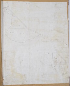
Map, Lerderderg Gorge Road Goodmans Creek to Gisborne Road
The date of this map and its purpose has not been established. It was possibly produced to indicate landholders who were impacted by works along the Lerderderg Gorge Road. A single page paper map showing various blocks of land along the route of the Lerderderg Gorge Road near Bacchus Marsh from Goodmans Creek to the point where the road joins with Gisborne Road. The map is pasted into a bound volume containing 76 maps or plans in total. High resolution digital image stored on BMDHS computer network. bacchus marsh victoria maps, lerderderg gorge road bacchus marsh maps -
 Whitehorse Historical Society Inc.
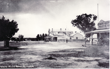
Photograph, North Corner of Whitehorse & Mitcham Road, Mitcham, c1920's
Black and white photo of the northern cnr Whitehorse and Mitcham Roads, Mitcham, showing Hughs Produce Store, with his white horse and delivery waggon outside. This was later the site of Mirama Court, later to be refurbished as shops and offices.|The vacant land on the far corner became a grocers shop and later the Westpac Bank. It is currently (2005) a computer sales shop.hughes produce store, mitcham road, mitcham, whitehorse road mitcham, mirama court mitcham, westpac bank -
 Tatura Irrigation & Wartime Camps Museum
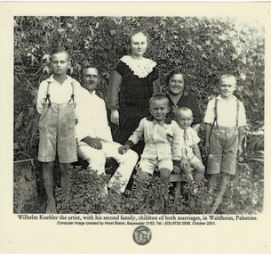
Photograph, Wilhelm Kuebler and family
Photograph of Wilhelm Kuebler and his second family. Wilhelm as an internee in Camp 3 at Rushworth during WW2.Black and white photograph of a man, woman and children posing in front of a backdrop shrubs. Man and woman and two children sitting, two boys and girl standing. Photograph has been laminated.Wilhelm Kuebler the artist, with his second family, children of both marriages, in Waldheim, Palestine. Computer image created by Horst Blaich, Bayswater 3153. Tel.: (03) 9720 2658 October 2001 round emblem underneath with side on head. Around the edge: Albert Blaich Family Archive 1970-2000wilhelm kuebler, camp 3 rushworth -
 Bendigo Military Museum
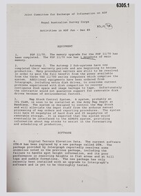
Administrative record - Joint Committee for the exchange of Information on ADP within the RASvy Corps, Activities Jun- Dec 1985, Army Survey Regiment, December 1985
Automated Computer Processing (ADP) was instrumental to the successful operation of the Royal Australian Survey Corps Mapping capability and production. This paper describes elements of the ADP with a comprehensive description of each. They Include, PDP 11/70 Memory, Map Stock Control System, Digital Terrain Elevation Data, Digital Terrain Model Package, ASMAPS, ASTIS, Reflectance Hill Shading, Aerial Triangulation and Terrain Analysis.Two page paper report about Automated Data Processing, unstapledHand annotated "Folio 74" in top right hand cornerroyal australian survey corps, rasvy, fortuna, army survey regiment, army svy regt, asr -
 Bialik College
Photograph (Item) - School photographs, c1980s, various activities
School photographs taken at various school events throughout the 1980s. Some specific photographs are labelled from 1984, showing students working on a computer, in the junior school, playing sport, musical instruments, art, woodworking room, library Includes Bnei Mitzvah photographs. Images from 1988, look to be at a school photography exhibition. No names included. For inquiries or access contact [email protected] school, bialik college, photographs., school -
 Stawell Historical Society Inc
Photograph, Various BIARRI photographs
7152: 8 PEOPLE, 7 PEOPLE SITTING AROUND A TABLE, 1 SITTING AT ANOTHER TABLE. 7152 -1: 4 PEOPLE SITTING AROUND A TABLE, OLD COMPUTER TO THE RIGHT. 7152-2 A GROUP OF PEOPLE SITTING AROUND A TABLE COVERED IN PAGES AND BOOKS. 7152-: 5 WOMEN STANDING HOLDING CERTIFICATES, ONE MALE SEATED IN FRONT HOLDING CERTIFICATE TO LEFT.biarri -
 Bacchus Marsh & District Historical Society
Map, Coimadai Parish Map, County of Bourke. Circa 1890s-1900s
The cadastral Parish of Coimadai, a subdivision of the County of Bourke, lies directly north of the township of Bacchus Marsh. The date of this map is uncertain. T.F. McGauran the person who made a photo-lithographic copy of the map was in charge of photo-lithography at the Victorian Department of Lands and Survey in the late 19th century until about 1910.A single page paper map showing the map for the Parish of Coimadai in the County of Bourke. A cadastral map showing parish boundaries and land ownership. A rectangle shaped area is missing from the centre of the map due to a tear or deliberate excision. The map is pasted into a bound volume containing 76 maps or plans in total. High resolution digital image stored on BMDHS computer network. Photo-lithographed at the Department of Lands and Survey, Melbourne by T.F. McGauran 26.8.[??] NOTE. Photo litho from L.P showing temporary surveys and occupation of land prepared for departmental use onlybacchus marsh region parish plans, coimadai parish maps, coimadai parish plan -
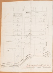 Bacchus Marsh & District Historical Society
Map, Langmann's Estate Bacchus Marsh
The date of this map has not been determined. It bears the signature of D.A. Little upon of a portion of the map. Little was Bacchus Marsh Shire Secretary and Engineer between 1886 and 1914 which dates the map to some time between 1886 and 1914.A single page paper map showing a portions of land in part of Bacchus Marsh.The area shown is described as Langmann's Estate. The area is bounded by the Werribee River, Fisken Street, Waddle Street(sic.) (Waddell) and Lord Street. The map is pasted into a bound volume containing 76 maps or plans in total. High resolution digital image stored on BMDHS computer network. interim map record stage 1, bacchus marsh victoria maps -
 Melbourne Tram Museum
Pamphlet, Yarra Trams, "Free TramTracker", Apr. 2013
Pamphlet, DL, printed on gloss card, titled "TramTracker" - Yarra Trams real time tram arrival information. Has the TramTRACKER logo (dog) foldout at the top of the card when folded into half. Provides instructions how to use it on the iPhone, Android and other smartphones. and computer systems. Advises passengers where to find the TramTRACKER ID for each stop. .1 - Hangingtrams, tramways, yarra trams, tramtracker, tram stops, operations, computer systems -
 Melbourne Tram Museum
Photograph - Digital Image, Kevin O'Reilly, Kew Barkers Rd, c1930
Image from CD (Compact Diskette for use in computers) - see Reg Item 135. Image titled "Kew Barkers Rd" on CD, looking west from over Kew Junction towards Victoria Bridge over the Yarra River. Has a W class tram, eastbound in Victoria St, about to cross the bridge. c1930 (Cable conversion late 1929)trams, tramways, kew, barkers rd, victoria st -
 Uniting Church Archives - Synod of Victoria
Photograph, 1979
David Norman Loader had been principal of an independent school in Orange NSW, and was appointed Principal of Methodist Ladies' College in 1979. Following his term at MLC, he was appointed Principal of Wesley College Melbourne 1997-2002. He was the driving force behind the establishment of the Clunes campus of Wesley and the introduction of notebook computers to the secondary years throughout Wesley. He retired to take on private consultancy work from 2002.B & W Gloss Head and Shoulders photograph of Mr David Loader, taken at the commencement of his Principalship of Methodist Ladies' College for "Church and Nation" in 1979.david norman loader; principal methodist ladies' college; principal wesley college melbourne -
Vision Australia
Audio (item) - Sound recording, Royal Victorian Institute for the Blind, Around the Institute: January 15, 2002
Around the Institute was a weekly program designed to keep clients and staff informed of events, activities and thoughts relating to low vision and blindness. It consisted of interviews undertaken by Jo Matthews-Lamb, Susan Thompson, Janet Cronin and Corey Nassau, with sound engineer Ed Gamble, designed to inform, educate and explore on a variety of topics. January 15: Computer training courses – Dale Moore, Hume region update – Julie Johnson.royal victorian institute for the blind, radio shows -
Vision Australia
Audio (item) - Sound recording, Royal Victorian Institute for the Blind, Around the Institute: September 4, 2001
Around the Institute was a weekly program designed to keep clients and staff informed of events, activities and thoughts relating to low vision and blindness. It consisted of interviews undertaken by Jo Matthews, with sound engineer Ed Gamble, designed to inform, educate and explore on a variety of topics. September 4: Recreation update – Chris Headland, Book review – Marcus Stacey, M40 program – Janet Cronin, Website and computer tips – Glen Morrow. royal victorian institute for the blind, radio shows -
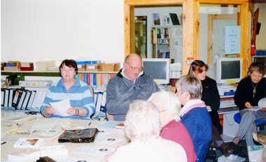
 Orbost & District Historical Society
coloured photographs, Snowy River Mail, second half 20th century
3098.28 is associated with Orbost Education Support Centre Country Education Project. It shows Helen Shiel and two men. 3098.29 is of a group working at desks with computers. One lady is standing. 3098.30 is a demonstration of Hi Tech for teachers and parents at the East Gippsland Conference and Expo at Bairnsdale. Joan Mehlert is in the photograph. 3098.31 shows a group of students of the Comm Skills 1 Evening Class. 3098.32 is associated with the Country Education Project Ruskin Street, Orbost.These photographs are associated with Adult Learning in Orbost.Five coloured photographs related to adult education.education-adult-learning-orbost country-education-project -
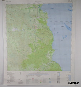 Bendigo Military Museum
Poster - Map Production flow chart poster using Automap 2, Army Survey Regiment, Bendigo, 1982
This poster designed to be folded into a brochure describes the second phase of the computer assisted cartographic system to be used by the Royal Australian Survey Corps in the establishment of a topographic data base, Future tactical applications and map products using the data base are displayed. A topographic map of Series R631 1:100,000 Helenvale, Queensland printed on the reverse side that was produced by the Automap system using information from the topographic data base. This is the fifth edition of the poster.A multi colour poster of map production using the Automap 2 system. Poster shows a schematic and pictorial flow chart diagram of the stages of the map production process using the Automap 2 system. The poster was intended to be folded into a small brochure. A 1:100,000 Army Survey Map Series R631, 7966 Helenvale, Queensland Edition 2 is printed on the reverse side of the poster. The map is an example of one of the initial maps produced on the Automap 2 System at the Army Survey Regiment, Bendigo.royal australian survey corps, rasvy, fortuna, army survey regiment, army svy regt, asr, automap 2 -
 Kiewa Valley Historical Society
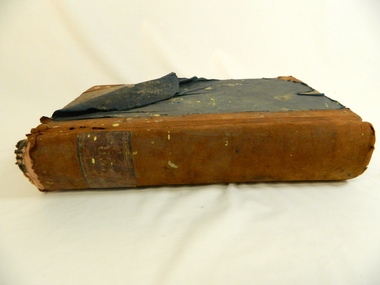
Book - Ledger Commercial, Ledger No 5, Commenced Jan 1st 1897, circa 1890's
Historically this ledger not only details the legible hand writing of this era but also the day to day commercial activity in this region. The neatness and the diligence of those who were required to pen the information was a requirement by all who were in commercial trade. Emphasis on neatness was ingrained in students at a young age. This era was well before general typewriters and computers. Generally all students of commerce required an accuracy in writing and arithmetic. Neatness and order were a selection requirement This item clearly identifies the Kiewa Valley as having a substantial financial hub to accommodate the various commercial enterprises within a rural environment Circa 1880's. Although Kiewa Valley had mining, agriculture, cattle and sheep it was also composed of a mixed society, encompassing all levels of society at that period. It identifies some family farming history in the specific year of 1897Leather reinforced corner covers and spine. Remaining book front and back covers are protected by blue weaved cloth. The covers are very thick cardboard, in layers. Missing front index pages C,E - 0,Q,T,U,V,XSpine of book marked in faded golden print "Ledger". First page in hand writing "Ledger No. 5" and underneath handwritten "Commenced Jan 1st !897" After the index pages each page (double sided) has a page number stamped in black and is 6mm highledger, early bookkeeping, local history, commerce circa 1890 -
Port Melbourne Historical & Preservation Society
Functional object - Shopping Bag, Bay Street Traders Association, 2001
Produced by and for the Bay Street Traders Association. .01 was produced first and printed on clear plastic, which made the images unreadable. Hence .02 was produced and printed on white plastic. Note that the 2000 scene is a computer generated image of what Bay Street may look like in the future, not as actually was in 2001. Similarly, the scene portrayed for 1800 does not reflect any reality as Liardet only landed at Sandridge in 1839. It may be an 1890s view.Black and white plastic promotional bag produced by the Bay Street Traders Association, purporting to show scenes of Bay Street in 1800 (sic) and 2000. Bears the Association logo.advertising, business and traders, bay street traders association, bay street -
Port Melbourne Historical & Preservation Society
Functional object - Shopping Bag, Bay Street Traders Association, 2001
Produced by and for the Bay Street Traders Association . .01 was produced first and printed on clear plastic, which made the images unreadable. Hence .02 was produced and printed on white plastic. Note that the 2000 scene is a computer generated image of what Bay Street may look like in the future, not as actually was in 2001. Similarly, the scene portrayed for 1800 does not reflect any reality as Liardet only landed at Sandridge in 1839. It may be an 1890s view.Black on clear plastic promotional bag produced by the Bay Street Traders Association, purporting to show scenes of Bay Street in 1800 (sic) and 2001. Bears the Association logo.advertising, business and traders, bay street traders association, bay street -
 Federation University Historical Collection
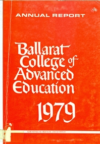
Book, Ballarat College of Advanced Education Annual Report, 1979, 1979
In 1980 the President was M.B. John. In 1980 the administration staff moved out of the lower level of the library and the space was converted for teaching use. Extensive alterations were made to the lower level of the mechanical/Civil Engineering wing for the housing of Applied Geology and Environmental Science. Car parking facilities were extended at Mt Helen.Orange soft covered book of 35 pages. Contents include: Courses, student numbers, Victorian School of Forestry, financial statement, Education Building (T Building) completed, Gillies Street Campus, Art building under construction, Great Hall (1870s Founders Hall) completion date expected to be mid 1980, Centenary Appeal, E.J. Barker Library, Computer Centre, bookshop . ballarat college of advanced education, bcae, mt helen, mount helen, library computer -
 Bendigo Historical Society Inc.
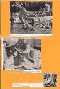
Newspaper - GOLDEN SQUARE P.S. LAUREL ST. 1189 COLLECTION: NEWSPAPER CUTTINGS
Yellow, laminated card with three newspaper cuttings. The first is a photo of Tracey Saunders in the 11 years high jump at the sports. The second is a photo are three girls learning to use a computer. They are Megan Baxter, Johanna White and Candice Reid. The third is a photo of Jaclyn Curnow and John Rainbow who received rewards recognising attitudes to school and fellow students, community - - (cut off) and sporting achievement.education, primary, golden square laurel st p.s., golden square primary school 1189 collection - newspaper cuttings, tracey saunders, megan baxter, johanna white, candice reid, jaclyn curnow, john rainbow -
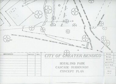 Bendigo Historical Society Inc.
Plan - MERLE HALL COLLECTION: ROSALIND PARK CREATIVE VILLAGE BENDIGO PROJECT CONCEPT PLAN, 1993
MERLE HALL COLLECTION: ROSALIND PARK CREATIVE VILLAGE BENDIGO PROJECT Concept Plan City of Greater Bendigo Rosalind Park Cascade Surrounds Concept Plan number GB095 Sheet 1 of 2 Level Book 365, Backup No Tape 01, Computer File No. ROS QEO. Large Sheet which shows the location of utilities, vegetation, drains, embankments etc. June 1993 -
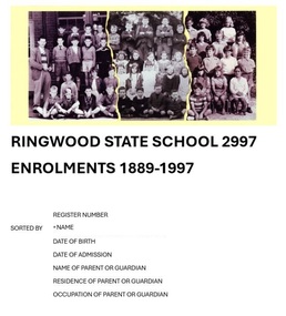 Ringwood and District Historical Society
Book, Ringwood State School 2997 - Enrolments 1889-1997
Blue A4 size 2-ring binder containing 129-page computer printout of transcribed Ringwood State School no.2997 rolls sorted alphabetically by pupil name, with details of register number, date of birth, date of admission, name of parent or guardian, and residential address and occupation of parent or guardian. List transcribed from original enrolment registers by Ringwood and District Historical Society, 2022. -
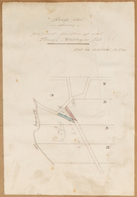
![Map, [Plan for road to give J. Allan access to permanent water at Coimadai] circa 1870s](/media/collectors/5e461d8021ea67224c82f2a1/items/67735190d671e67dd573a84c/item-media/6773533dd671e67dd573cd90/item-fit-380x285.jpg) Bacchus Marsh & District Historical Society
Bacchus Marsh & District Historical SocietyMap, [Plan for road to give J. Allan access to permanent water at Coimadai] circa 1870s
The date of this map or plan is uncertain but it appears to be from the early to mid 1870s. One of the landholders identified on the plan, James Allan of Coimadai died suddenly on the 9th July, 1874 (see Bacchus Marsh Express, 11 July, 1874, page. 3). There are mentions of an Allans Road at Coimadai in the Bacchus Marsh Express between 1887 and 1942.Single page map showing an excision of land belonging to Charles Ross which was selected to construct a road to give another landholder, J. Allan access to permanent water. Scale 1 chain to 1 inch. Part of a set of maps which are pasted into a bound volume containing 76 maps or plans in total. High resolution digital image stored on BMDHS computer network. Plan showing Excisions from Ross's selection and 1 chain road thro' the said selection in Coimadai to give J. Allan access to permanent water. Alistair ?? Shire Eng? 6?/5/7?coimadai victoria maps, coimadai roads and streets -
 Bacchus Marsh & District Historical Society
Map, Rough plan showing proposed deviation of road through McKenzie's Flat
The date of this map or plan is uncertain. McKenzie's Flat is a bushland picnic area on the Lerderderg River in the Lerderderg State Park close to Bacchus Marsh. Single page map showing a proposed deviation of the road near the McKenzie's Flat area close to Bacchus Marsh. The proposed deviation is shaded in pink, The existing road section to be replaced is shaded in blue. No scale is indicated. Part of a set of maps which are pasted into a bound volume containing 76 maps or plans in total. High resolution digital image stored on BMDHS computer network. mckenzies flat bacchus marsh, bacchus marsh roads and streets -
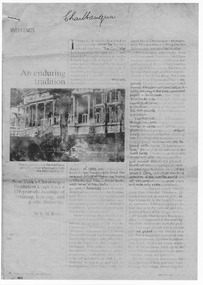 Halls Gap & Grampians Historical Society
Document - Fax of article (magazine/newspaper)
The article is c.1993. Chautauqua peak is named after the Chautauquans, who held summer camps in Halls Gap in the 1890s. NOTE: Additional images are second and third pages, and a Microsoft Word file which includes the text of all three pages. A PDF file of an "augmented copy of the fax (with the more difficult to read sections clarified in pencil) is also available in the \Pictures\MP Navigator\2009_09_-02 directory on the computer (as there is not further space to attach it to this record)A copy of a three page National Geographic Traveler article entitled 'An enduring tradition'. The article describes the reporter's trip to Lake Chautauqua where the Chautauqua Institution was founded, and includes historical information about the Chautauquans.Chautauqua written in ball-point pen on top of front page.media, magazine articles -
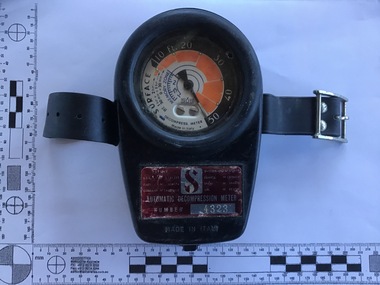 Queenscliffe Maritime Museum
Equipment - The ScubaPro Automatic Decompression Meter 1966 in original box
First available in ScubaPro’s catalogue in 1966, the ScubaPro Automatic Decompression Meter was a break through in diving technology and a forerunner to the modern dive computer. The meter attempted to calculate nitrogen absorption based on dive time and depth. This was done mechanically instead of electronically, and without the benefit of any actual computing. The Automatic Decompression Meter was introduced just a year after ScubaPro’s most successful product – the ScubaPro Jet Fins – which still remain popular today. Used by divers since 1966The ScubaPro Automatic Decompression Meter 1966 in original box Automatic Decompression Meter Number 4323 made in Italydiving, decompression meter, scubapro -
 Ballarat Tramway Museum
Newspaper, Paul Nolan and Glenn Shields, "Jenkins calls for tourist trolleys on our streets", 26/2//1997
Article in The Courier, Ballarat 26/2/1997, page 3, written by Paul Nolan reporting on the proposals by Paul Jenkins MLA for Ballarat West that motor buses dressed as "trolleys" be used to transport visitors around Ballarat prior to the reintroduction of trams to Ballarat streets. Features a computer image by Glenn Shields of on the Disneyland "trolleys" superimposed on the photo of the Ballarat Town Hall. (btm1511i1) and a cartoon by Burns (btm1511i2)."Wednesday February 26 1997 pg3" in blue ink along top right hand edge.tourist bus, ballarat city tramway, ballarat revival, disneyland -
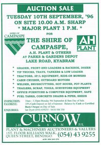 Bendigo Historical Society Inc.
Document - IAN DYETT COLLECTION: AUCTION CATALOGUE - THE SHIRE OF CAMPASPE, A H PLANT & OTHERS
White catalogue with green printing for a sale on the 10th September, '96 on account of The Shire of Campaspe, A. H. Plant & Others. For sale were tip trucks, grader, tractors, cabin cruiser, welder, garden equipment, scrap, tools, surveyors equipment, office furniture, computer equipment, safe, fuel tanks, concrete drains & pipes and sheds. J. H. Curnow & Son P/L were the auctioneers.business, auctioneers, j h curnow & son pty ltd, ian dyett collection - auction catalogue - the shire of campaspe a h plant & others, ian dyett, j h curnow & son p/l, noel dyett, fred dyett -
 Bacchus Marsh & District Historical Society
Map, Plan of land purchased by the Bacchus Marsh Shire Council from Mr. T. Low for a deviation of the Melbourne to Ballarat main road. 1877
The date of this plan is 1877 and the land indicted on it required for a road deviation is shaded in blue. It adjoins the Korkuperrimul Creek on one side which indicates the land is located just a few kilometers to the west of Bacchus Marsh. Single page map showing a portion of land purchased by the Bacchus Marsh Shire from Mr Thomas Low for the purpose of a road deviation. Land held by David Robertson is also shown on the map. Scale: 2 chains to 1 inch. Part of a set of maps which are pasted into a bound volume containing 76 maps or plans in total. High resolution digital image stored on BMDHS computer network. Surveyed by W. E. Standfield, Shire Engineer, Bacchus Marsh, 12/4/77bacchus marsh roads and streets, melbourne to ballarat road -
 Bacchus Marsh & District Historical Society
Map, Gaynor Street Area Land Sales, Maddingley, 1888
This map was produced for a major sale of land in the Maddingley area of Bacchus Marsh in 1888. The sale was conducted by two firms from Melbourne, Carney and Kelly 12 Swanston Street Melbourne. and 'Richardson, Kerr & Co. 40 Flinders Lane Melbourne. 136 blocks were for sale.A single page paper map showing land allotments for sale in the Maddingley area of Bacchus Marsh. Locations shown include Gaynor Street, Maddingley Road South, Parwan Road, Mitchem Street, Typpynge Street, Finn Street and East Maddingley Road. . The map is pasted into a bound volume containing 76 maps or plans in total. High resolution digital image stored on BMDHS computer network. bacchus marsh victoria maps, maddingley victoria maps, land use, maddingley victoria history, land sales bacchus marsh, land sales maddingley