Showing 526 items
matching drainage
-
 Port Melbourne Historical & Preservation Society
Document - Scrapbook, Newspaper cuttings relating to Port Melbourne, Edward C Crockford, Town Clerk, 1890s
EC CROCKFORD's scrapbook from time he became acting Town Clerk (1892) until he left to serve South Melbourne (1909).Scrapbook kept by Port Melbourne Town Clerk EC CROCKFORD, 1890s: notebook with marbled board covers, 38 ruled pp, some empty. Back of book used upside down. Pasted with clippings related to municipal operation, and ads for contracts (in back). Insert: note on rateslocal government - town of port melbourne, engineering department - town of port melbourne, transport - railways, transport - tramways, engineering - roads streets lanes and footpaths, engineering - canals and drainage, amalgamation, piers and wharves - station pier, business and traders, sport - lawn bowls, health - general health, law, nightsoil, piers and wharves - railway pier, statistics, edward c crockford, town clerks, municipal elections -
Port Melbourne Historical & Preservation Society
Document - Scrapbook relating to Port Melbourne, Newspaper Cuttings, 1900
98 pages of clippings kept by Port Melbourne Town Clerk E.C. CROCKFORD; sequential to item 162. (This also has his bowling scores in back). NB Crockford supposed to have moved to South Melbourne in November, 1909, but this book kept up to 28-07-1910, apparently still in Crockford's handwriting.Notationslocal government - town of port melbourne, engineering - board of works, melbourne harbor trust - port of melbourne authority, sandridge lagoon, livestock, piers and wharves - miscellaneous, amalgamation, royal visits and occasions, law, sport - lawn bowls, transport - tramways, health - general health, business & traders - dairies, flood, transport - horse, transport - railways, environmental issues, fishermans bend, engineering - canals and drainage, hotels, built environment - domestic, celebrations fetes and exhibitions, town planning - proposals shelved, natural environment, edward c crockford, town clerks, pumping station, waste disposal, sand carters -
Port Melbourne Historical & Preservation Society
Map - MMBW, c. 1894
Melbourne and Metropolitan Board of Works Plan No. 323,330, 335, 336 Segments shown: As Plan No. Large scale plan of lagoon fill area (40'=1")engineering - board of works, sandridge lagoon, transport - tramways, engineering - canals and drainage, built environment, gasworks, hotels -
Port Melbourne Historical & Preservation Society
Book - Town of Port Melbourne, Arthur Victor Heath, Town Surveyor et al, Surveyors Report Book, 1901
Reports to Council hand entered by Town Surveyor and ATS, with marginal notes on actions taken by Council.Book of reports of Port Melbourne Town Surveyor 1901-1911: 475 pp volume bound in dark green with maroon spine and corners. Gold stamped on spine 'Minute Book' but added leather label below reads 'Surveyors Report Book'. Some inserts (glued in)Stamped inside cover and on some pages, 'Town of Port Melbourne Surveyors Office'sandridge lagoon, local government - town of port melbourne, fishermans bend, flood, fire and fire services, port melbourne town hall, transport - horse, transport - tramways, parks and gardens, engineering - roads streets lanes and footpaths, excelsior hall, societies clubs unions and other organisations, built environment, hotels, industry - manufacturing, engineering - canals and drainage, crimes and misdemeanours, transport - ferries, south melbourne, arthur victor heath, george beazley, h v champion -
Port Melbourne Historical & Preservation Society
Book - Borough of Sandridge, Charles Clay, Borough Surveyor, Surveyor's Reports, 1877
Surveyor Charles CLAY's reports to Council March 1877 to June 1882, handwritten. 176pp volume bound in maroon linen with red spine; sticker on front: MINUTE BOOK; 'Surveyor's Reports' hand printedThree names/addresses noted on first page. Two printed Agendas 1881 and 1882 pasted in front.local government - borough of sandridge, engineering - roads streets lanes and footpaths, port melbourne town hall, transport - tramways, engineering - canals and drainage, celebrations fetes and exhibitions, business and traders, fishermans bend, fire and fire services, flood, engineering - bridges, utilities, health - general health, hotels, built environment - domestic, industry - manufacturing, livestock, transport - railways, charles clay, sandridge lagoon -
Port Melbourne Historical & Preservation Society
Plan - Reclamation Fishermans Bend with material dredged from Coode Canal, Melbourne Harbor Trust, 1940
One of two A3 photocopies from MHTC plans of proposals for reclaiming Fishermans (sic) Bend with materials dredged from widening of Coode Canal, 1940 (Second copy missing April 2019)Pencil notations re Rotten Row etc.fishermans bend, engineering - canals and drainage, coode canal, melbourne harbor trust - port of melbourne authority -
Port Melbourne Historical & Preservation Society
Plan - Suggested Alterations, Port Melbourne Pumping Station, Engineering Department, City of Port Melbourne
Plan showing suggested alterations to Port Melbourne Pumping Station, date unknown.engineering - canals and drainage, sandridge lagoon -
Port Melbourne Historical & Preservation Society
Document - Specifications, Main drain, west branch, Evans Street to Esplanade East, Port Melbourne, Arthur Victor Heath, Town Clerk et al, 14 Mar 1893
Specifications for the construction of main drain west branch 1893 (together with plan attached - refer 75.2)A.V. Heath (Town Surveyor):J.J. Bartlett (Mayor)engineering - canals and drainage, arthur victor heath, town clerks, james john bartlett, mayors -
Port Melbourne Historical & Preservation Society
Plan - Main drain, west branch, Evans Street to Esplanade East, Port Melbourne, 14 Mar 1893
Plan of main drain west branch, from Evans Street to Esplanade East (together with written specifications attached - refer 75.1) 1893.J.J. Bartlett (Mayor) 14/3/93engineering - canals and drainage, arthur victor heath, town clerks, james john bartlett, mayors -
Port Melbourne Historical & Preservation Society
Plan - Melbourne and suburbs sewerage works, MMBW, 1 Jul 1908
MMBW map of Melbourne and Suburbs sewerage work to 1-7-1908. Reticulation areas in red, reticulation areas under construction in blue.engineering - canals and drainage, engineering - board of works -
Port Melbourne Historical & Preservation Society
Book - Minutes, Port Melbourne Town Council, Edward C Crockford, Town Clerk, c. 1900
Large volume of rough minutes Port Melbourne Town Council May 1901 - April 1904, with typed and printed minutes inserted throughout - dark green, dark red binding loose and partly missingdeaths and funerals, built environment, port melbourne town hall, societies clubs unions and other organisations, local government - town of port melbourne, social activities, built environment - civic, excelsior hall, engineering - canals and drainage, transport - tramways, edward c crockford, town clerks, port melbourne library -
Port Melbourne Historical & Preservation Society
Document - Delivery docket, A E HOCKING for repaired magneto, 8 Jan 1923
Found in pages of item 588 (Town Clerk's Reports); probably related to the running of the pumphouseDelivery docket from A.E. HOCKING of Crockford Street for repaired magneto, signed by George BEAZLEY on behalf of Port Council, 1923Small figures on back in pencilsandridge lagoon, engineering - canals and drainage, george beazley, a e hocking -
Port Melbourne Historical & Preservation Society
Photograph - Canal at Fishermen's Bend, 1886
View of canal at Fishermen's Bend 1886. East end - showing inflow of water, during flooding.On rear: SLTF 919.45 M48F Views of canal at Fishermen's Bend 1886. View No 5 - General view East end - inflow of water.engineering - canals and drainage -
Port Melbourne Historical & Preservation Society
Photograph - Sketch, Excavation of the Coode Canal and Reclaiming Land, 1880
Photograph of Sketch - Excavation of the Coode Canal And Reclaiming Land. 1880engineering - canals and drainage -
Port Melbourne Historical & Preservation Society
Plan - Port Melbourne, MMBW, 1987
Very large MMBW plan of Port Melbourne 1987 made up of several sections taped together; drains indicated in blackPMH&PS stamp on backengineering - canals and drainage, mmbw, melbourne and metropolitan board of works -
 Port Melbourne Historical & Preservation Society
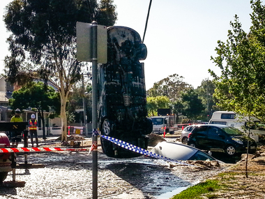
Document - Sink-hole, Liardet Street, Port Melbourne, 17 Dec 2014
In the early hours of Tuesday 16 December, 2014 a water main burst in Liardet St. The resulting sink-hole swallowed two cars and left a massive hole which took 8 days to repair and re-open the road. Several houses on the city side of Liardet St suffered water damage and water also entered the underground car park of the apartment block on the beach side.Photos taken of the damage and vehicle recoveries when a sink-hole opened up on Liardet Street on Tuesday 16 December 2014.built environment - domestic, engineering - roads streets lanes and footpaths, engineering - canals and drainage, liardet street, water supply, fran egan -
 Port Melbourne Historical & Preservation Society
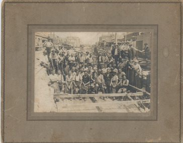
Photograph - Workers in main drain excavation, Princes Street, Port Melbourne, 1933
Thought to be MMBW works on the main Princes Street pipeline. The 'original', which appears to be a framed, sepia original, is actually screened, so has appeared in a publication at some point. It belonged to Beryl nee BROWN, whose father 'Gus' BROWN is one of the workers. Lasercopy from photo loaned for copying and later donated (item 799.01), then digitally restored (item 799.02), of workers in main drain excavation, Princes Street, 1933.sydney "gus" brown, mmbw, engineering - canals and drainage, princes street, melbourne and metropolitan board of works -
 Port Melbourne Historical & Preservation Society
Photograph - Workers in main drain excavation, Princes Street, Port Melbourne, 1933
Given to member Jan MacDonald by Beryl nee BROWN , whose father is one of the workers in the photo. Appears to be an original photo but an enlargement reveals it's a half- tone , so could have been copied from a publication. 'Gus' BROWN appears in third row from front 1933 photograph of construction workers in the excavation for the main drain in Princes Street. Sepia, mounted on cardboard 'frame'. Appears to be an original but is actually a halftone.Top left on back, in ink 'Kelly'engineering - board of works, engineering - canals and drainage, hotels, built environment, sydney 'gus' brown, swallow & ariell ltd -
 Port Melbourne Historical & Preservation Society
Photograph - Photograph (digitally restored), Workers in main drain excavation, Princes Street, Port Melbourne, Appro Images, 1933
Digitally restored print of 1933 photograph of construction workers in the excavation for the main drain in Princes Street (799.01).engineering - board of works, engineering - canals and drainage, hotels, built environment, sydney 'gus' brown, swallow & ariell ltd -
Port Melbourne Historical & Preservation Society
Book - Submission for AFC Construction Achievement Award, Bayside clean-up project, Roche Bros, 1991
(1)Submission for 1991 AFCC Construction Achievement Award. Bayside clean-up project. (2-3) Two clippings form "The Age" regarding the project.natural environment, engineering - canals and drainage, roger bacon, urban land authority, reeves construction engineers, rms consultants -
Port Melbourne Historical & Preservation Society
Photograph - Renewal of storm water drain, Esplanade West, Port Melbourne, Janet Bolitho, Jul 2002
Five coloured photographs of renewal of storm water drain Esplanade West. .01 Esplanade East Street sign .02 Digging .03 Putting in pipe .04 large casing on end of crane .05 Workersbuilt environment - civic, engineering - canals and drainage, natural environment, sandridge lagoon, esplanade east, hmas lonsdale, stormwater drain, melbourne and metropolitan board of works -
Port Melbourne Historical & Preservation Society
Map, City of Port Melbourne, Oct 1963
Gives a visual understanding of the Port Melbourne area in 1963A detailed map of the Port Melbourne area in October 1963. Details roads and laneways, undeground cables, light and power poles, sewer, bridges, piers reserve and park areas.local government, built environment, piers and wharves, natural environment - beaches and foreshore, parks and gardens, piers and wharves - princes pier, piers and wharves - station pier, engineering - roads streets lanes and footpaths, engineering - canals and drainage -
Port Melbourne Historical & Preservation Society
Photograph - Main drain reconstruction, Cruikshank Street, Port Melbourne, Outfall Timber Drain Reconstruction, 23 Aug 2004
Photographs & plans supplied by Melbourne water of Cruikshank Street main drain reconstruction of bay outfall. 2004 .01 19x25 colour photo of clear spanning footing .02 19x25 colour photo of outer edge of drain .03 19x25 colour photo of top deck of drain .04 19x25 colour photo of excavation .05 - .08 19x25 colour photo of excavation of drain .09 - .12 colour photo of excavation of drain .13 - .14 22x33 colour photo of plan of area .15 - .17 39x53 drawn plan of area surrounding .18 - .19 39x53 Cruickshank St main drain reconstruction .20 Initial e-mail letter regarding drain (3-8-04) .21 Business card, Melbourne Water's Paul Balassomeengineering - canals and drainage, cruickshank street -
 Kew Historical Society Inc
Photograph - Flooding of the Yarra Valley at Kew East, 1974
Flooding of the Yarra Valley, including that section of the Yarra bordering Kew and Kew East in the north and west of the municipality, was a regular occurrence. Extreme flood events of the Yarra River are recorded to have occurred in 1891, 1901, 1916, 1923 and 1934. The Municipality of Kew's response to these floods was to enact planning decisions restricting residential development in flood prone areas following the floods of 1916, 1921 and 1934. While floods continued after the development of the Upper Yarra Reservoir (construction 1948-57), the regularity and extent of these inundations diminished. During the nineteenth century, the land abutting the south side of the Yarra in Kew was devoted to dairy farming. In the twentieth century, before and after the construction of the Eastern Freeway, much of this low-lying area was used as golf courses and public parks.Late example of the capacity of the Yarra Valley at Kew to flood, even though drainage works and the Upper Yarra Reservoir had reduced their regularity.Original black and white print photograph of the low-lying land at East Kew under floodwater on 16 May 1974. The vantage point of the photographer is Lister Street. In the photo, the fences of the Kilby Farm can be seen. Flooding was caused by overflowing water in Glass' Creek and the River Yarra. Annotation verso: "Hay's Paddock op No.30 Lister Street / 16 May 1974 11.50am / R.L. 46.04"hays paddock, floods, yarra river, glass' creek, lister street -
 Kew Historical Society Inc
Photograph - Flooding of the Yarra Valley at Kew East, 1974
Flooding of the Yarra Valley, including that section of the Yarra bordering Kew and Kew East in the north and west of the municipality, was a regular occurrence. Extreme flood events of the Yarra River are recorded to have occurred in 1891, 1901, 1916, 1923 and 1934. The Municipality of Kew's response to these floods was to enact planning decisions restricting residential development in flood prone areas following the floods of 1916, 1921 and 1934. While floods continued after the development of the Upper Yarra Reservoir (construction 1948-57), the regularity and extent of these inundations diminished. During the nineteenth century, the land abutting the south side of the Yarra in Kew was devoted to dairy farming. In the twentieth century, before and after the construction of the Eastern Freeway, much of this low-lying area was used as golf courses and public parks.Late example of the capacity of the Yarra Valley at Kew to flood, even though drainage works and the Upper Yarra Reservoir had reduced their regularity.Original black and white print photograph of the low-lying land at East Kew under floodwater on 16 May 1974. The vantage point of the photographer is Lister Street. Flooding was caused by overflowing water in Glass' Creek and the River Yarra. Annotation verso: "Lister Street looking north / Flood level / 16 May 1974 11.30am / R.L. 46.04"hays paddock, floods, yarra river, glass' creek, lister street -
 Kew Historical Society Inc
Photograph - Flooding of the Yarra Valley at Kew East, 1974
Flooding of the Yarra Valley, including that section of the Yarra bordering Kew and Kew East in the north and west of the municipality, was a regular occurrence. Extreme flood events of the Yarra River are recorded to have occurred in 1891, 1901, 1916, 1923 and 1934. The Municipality of Kew's response to these floods was to enact planning decisions restricting residential development in flood prone areas following the floods of 1916, 1921 and 1934. While floods continued after the development of the Upper Yarra Reservoir (construction 1948-57), the regularity and extent of these inundations diminished. During the nineteenth century, the land abutting the south side of the Yarra in Kew was devoted to dairy farming. In the twentieth century, before and after the construction of the Eastern Freeway, much of this low-lying area was used as golf courses and public parks.Late example of the capacity of the Yarra Valley at Kew to flood, even though drainage works and the Upper Yarra Reservoir had reduced their regularity.Original black and white print photograph of Hay's Paddock under floodwater on 16 May 1974. The vantage point of the photographer is Keystone Crescent looking east. Flooding was caused by overflowing water in Glass' Creek and the River Yarra. Annotation verso: "Keystone Cr looking east / 16 May 1974 11.50am"hays paddock, floods, yarra river, glass' creek -
 Kew Historical Society Inc
Photograph - Flooding of the Yarra Valley at Kew East, 1974
Flooding of the Yarra Valley, including that section of the Yarra bordering Kew and Kew East in the north and west of the municipality, was a regular occurrence. Extreme flood events of the Yarra River are recorded to have occurred in 1891, 1901, 1916, 1923 and 1934. The Municipality of Kew's response to these floods was to enact planning decisions restricting residential development in flood prone areas following the floods of 1916, 1921 and 1934. While floods continued after the development of the Upper Yarra Reservoir (construction 1948-57), the regularity and extent of these inundations diminished. During the nineteenth century, the land abutting the south side of the Yarra in Kew was devoted to dairy farming. In the twentieth century, before and after the construction of the Eastern Freeway, much of this low-lying area was used as golf courses and public parks.Late example of the capacity of the Yarra Valley at Kew to flood, even though drainage works and the Upper Yarra Reservoir had reduced their regularity.Original black and white print photograph of the low-lying land at East Kew under floodwater on 16 May 1974. The vantage point of the photographer is Lister Street. Flooding was caused by overflowing water in Glass' Creek and the River Yarra. Annotation verso: "Lister St looking same as No.3 / 16 May 1974 11.30"floods, yarra river, glass' creek, lister street -
 Kew Historical Society Inc
Photograph - Flooding of the Yarra Valley at Kew East, 1974
Flooding of the Yarra Valley, including that section of the Yarra bordering Kew and Kew East in the north and west of the municipality, was a regular occurrence. Extreme flood events of the Yarra River are recorded to have occurred in 1891, 1901, 1916, 1923 and 1934. The Municipality of Kew's response to these floods was to enact planning decisions restricting residential development in flood prone areas following the floods of 1916, 1921 and 1934. While floods continued after the development of the Upper Yarra Reservoir (construction 1948-57), the regularity and extent of these inundations diminished. During the nineteenth century, the land abutting the south side of the Yarra in Kew was devoted to dairy farming. In the twentieth century, before and after the construction of the Eastern Freeway, much of this low-lying area was used as golf courses and public parks.Late example of the capacity of the Yarra Valley at Kew to flood, even though drainage works and the Upper Yarra Reservoir had reduced their regularity.Original black and white print photograph of the low-lying land at East Kew under floodwater on 16 May 1974. The vantage point of the photographer is at Willsmere Road. The road itself is underwater.Annotation verso: "Willsmere Rd / Same as No.7 / 16 May 1974 11.15am"floods, yarra river, willsmere road -
 Kew Historical Society Inc
Photograph - Flooding of the Yarra Valley at Kew East, 1974
Flooding of the Yarra Valley, including that section of the Yarra bordering Kew and Kew East in the north and west of the municipality, was a regular occurrence. Extreme flood events of the Yarra River are recorded to have occurred in 1891, 1901, 1916, 1923 and 1934. The Municipality of Kew's response to these floods was to enact planning decisions restricting residential development in flood prone areas following the floods of 1916, 1921 and 1934. While floods continued after the development of the Upper Yarra Reservoir (construction 1948-57), the regularity and extent of these inundations diminished. During the nineteenth century, the land abutting the south side of the Yarra in Kew was devoted to dairy farming. In the twentieth century, before and after the construction of the Eastern Freeway, much of this low-lying area was used as golf courses and public parks.Late example of the capacity of the Yarra Valley at Kew to flood, even though drainage works and the Upper Yarra Reservoir had reduced their regularity.Original black and white print photograph of the low-lying land at East Kew under floodwater on 16 May 1974. The photograph is of Hyde Park looking north-east.Annotation verso: "Hyde Park looking nth-east / Flood Level / 16 May 1974 11.15am / R.L. 46.61"floods, yarra river, hyde park -
 Kew Historical Society Inc
Photograph - Flooding of the Yarra Valley at Kew, 1974
Flooding of the Yarra Valley, including that section of the Yarra bordering Kew and Kew East in the north and west of the municipality, was a regular occurrence. Extreme flood events of the Yarra River are recorded to have occurred in 1891, 1901, 1916, 1923 and 1934. The Municipality of Kew's response to these floods was to enact planning decisions restricting residential development in flood prone areas following the floods of 1916, 1921 and 1934. While floods continued after the development of the Upper Yarra Reservoir (construction 1948-57), the regularity and extent of these inundations diminished. During the nineteenth century, the land abutting the south side of the Yarra in Kew was devoted to dairy farming. In the twentieth century, before and after the construction of the Eastern Freeway, much of this low-lying area was used as golf courses and public parks.Late example of the capacity of the Yarra Valley at Kew to flood, even though drainage works and the Upper Yarra Reservoir had reduced their regularity.Original black and white print photograph of the low-lying land at East Kew under floodwater on 16 May 1974. The photograph is taken from 43 Kellett Grove.Annotation verso: "Kellett Gve No.43 / Flood Level / 16 May 1974 11.40am"floods, yarra river, kellett grove