Showing 1087 items matching " navigation"
-
 Queenscliffe Maritime Museum
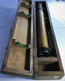
Instrument - Telescope in timber box
A telescope in its own timber box.Turn this to change powertelescope, navigation -
 Queenscliffe Maritime Museum
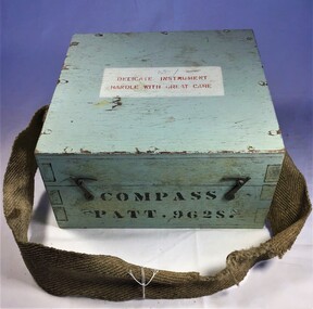
Instrument - Compass
8 cm compass Pattern 9628 in wooden boxCompass Patt 9628S Delicate instrument handle with care 287A/62compass, navigation -
 Queenscliffe Maritime Museum
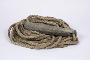
Equipment - Sounding lead line
Although the provenance cannot be confirmed it is believed that this lead possibly originated from the SS Time.Since at least the sixth century B.C. the sounding lead or sounding weight was in use in the Mediterranean area for maritime navigation. It is the oldest known marine navigational instrument and it remained a primary navigational aid in coastal waters and rivers well into the twentieth century.A sounding lead with rope line attached. One surviving leather fathom depth marker is spliced into the rope.sound lead, navigation -
 Lakes Entrance Historical Society
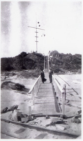
Photograph - Flagstaff, 1910c
Black and white photograph showing flagstaff and signal baskets on dunes, two women in long dresses on boardwalk, tram track on beach in front of unfinished boardwalk, vegetation on dunes. Lakes Entrance Victorianavigation, boardwalk -
 Lakes Entrance Historical Society
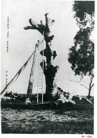
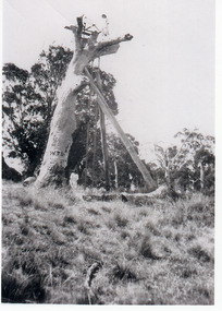
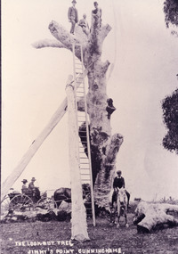
Photograph - Lookout tree, Bulmer H D, 1910 c
Also copy 15 x 10 same imageBlack and white photograph copied from a postcard of the LookOut Tree on Jemmys Point, shows the standing dead grey box tree supported by two heavy logs, a 35 foot ladder attached for access to top. Lakes Entrance Victoria.historic sites, navigation -
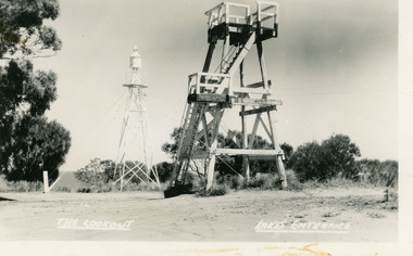
 Lakes Entrance Historical Society
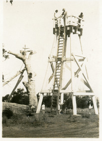
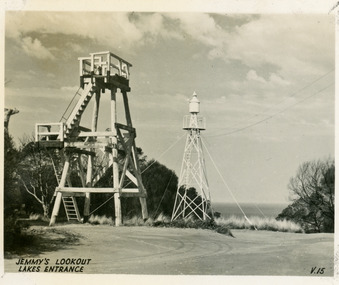
Postcard - Lookout tower Jemmys Point, 1929
Also, two enlargements, 10 x 15 cm, and one enlargement 17 x 25 cm, all purchasedSmall format postcard showing the first observation lookout erected on Jemmys Point, Lakes Entrance, Victoria, showing a timber structure about 30 feet high with a fenced platform on top, narrow ladder leading straight to top from ground. Five people on ground, three on platform. Old LookOut Tree standing in background.On reverse, 'LookOut Jemmys Point, Lakes Entrance'historic sites, navigation -
 Lakes Entrance Historical Society
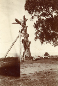
Photograph - Lookout tree, 1910
Black and white small format photograph of the LookOut Tree at Jemmys Point, showing dead tree supported by two logs, a woman two-thirds of the way up the 35 foot ladder which reaches the top. Lakes Entrance, Victoriahistoric sites, navigation -
 Lakes Entrance Historical Society
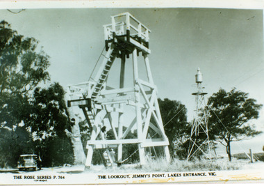
Photograph - Lookout tower Jemmy's Point, The Rose Series, 1950
Identical copy 10 x 15Black and white photograph copied from a postcard showing the timber lookout tower and signal light on Jemmys Point, old lookout tree in background appears to have some of the top missing. Lakes Entrance Victoria.The Lookout Jemmy's Point Lakes Entrancehistoric sites, navigation -
 Lakes Entrance Historical Society
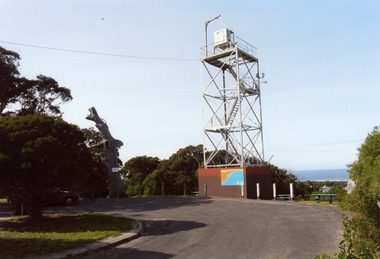
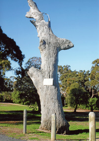
Photograph - Lookout tower Jemmy's Point, Price Wendy, 2008
This is the after paired photograph used in the 150 year Lakes entrance 1858-2008 display.|The before paired photograph number 02269|Also one 12 x 16 framed photograph used in room display.Colour photograph lookout tree and steel signal light tow on Jemmys Point. Lakes Entrance Victoria.historic sites, navigation -
 Lakes Entrance Historical Society
Photograph - Lookout tree, 1927
Black and white photograph of the Lookout Tree on Jemmys Point showing a standing dead grey box tree supported by two long timbers. Access to the top via a 35 foot ladder. Thelma Roder standing on top beside signal structure, two women and child standing near base. Lakes Entrance Victoria,historic sites, navigation -
 Lakes Entrance Historical Society
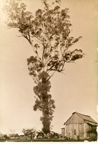
Photograph - Historic tree Kalimna West, 1920
Sepia photograph of a tall tree on James Rowes property at Kalimna West. This tree was a landmark for shipping at sea off Lakes Entrance during late 19th and early 20th Centuries. It was later struck by lightning, cut down and hewn into sleepers and beams. Kalimna West Victoriahistoric sites, navigation -
 Lakes Entrance Historical Society
Postcard - Lookout tower Jemmy's Point, Valentine Series, 1940
Black and white small format postcard of the timber observation lookout at Jemmys Point, Lakes Entrance, Victoria, showing the timber tower with observation deck, signal light on steel tower nearby. Top of old standing lookout tree just visible.Jemmys Lookout Lakes Entrancehistoric sites, navigation -
 Lakes Entrance Historical Society
Postcard - Lookout tower Jemmy's Point, Bulmer H D, 1950
Black and white postcard of the timber lookout on Jemmys Point, with the signal light on steel tower nearby. Lakes Entrance Victoria,The Lookout, Lakes Entrancehistoric sites, navigation -
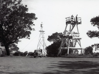 Lakes Entrance Historical Society
Photograph - Lookout tower Jemmy's Point, 1960
Also one other photograh similar showing steps, landing, and Carpenters Chev car parked.Black and white photograph of the timber lookout on Jemmys Point, steel tower with signal light in background, base of old lookout tree visible on left of image. Lakes Entrance, Victoria.historic sites, navigation -
 Lakes Entrance Historical Society
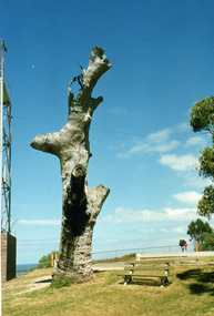
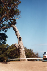
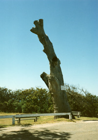
Photograph - Lookout tree, 1990
Colour photograph of the old lookout tree on Jemmys Point, showing a standing dead grey box tree, remains of three branches at top which once held a platform and signal structure. Two timber seats on lawn at base, roadway in foreground. Lakes Entrance, Victoria,2008historic sites, navigation -
 Lakes Entrance Historical Society
Photograph - Lookout tree, 1990
Colour photograph of the old lookout tree on Jemmys Point, showing a standing dead grey box tree, remains of three branches at top which once held a platform and signal structure. Two timber seats on lawn at base, roadway in foreground. Lakes Entrance, Victoria,historic sites, navigation -
 Lakes Entrance Historical Society
Photograph - Lookout tree, 1900
Image appears to be copied from an original postcard, maker unidentified|Also and enlarged copy of photograph 27 x 17Colour photograph of the LookOut Tree on Jemmys Point, shows a dead standing grey box tree supported by two logs and with a ladder over thirty feet long attached for access to the four branches used as a viewing platform. One person sitting on top, man in Indian dress halfway up ladder. Lakes Entrance Victoria.LookOut Tree at Lakes Entrance Cunninghame, Victoriahistoric sites, navigation -
 Moorabbin Air Museum
Manual - Trans Australia Airlines training manuals, TAA Training Manual Boeing 727 Nav/AFCS Book No.2
Overview of=Boeing 727 navigation & auto flight systems for traihess, circa 1980Spiral bound manualnon-fictionOverview of=Boeing 727 navigation & auto flight systems for traihess, circa 1980navigation, auto pilot -
 Lakes Entrance Historical Society
Photograph - Lookout tree c1910, 1910
On back of original 'What price our Yankees climbing trees?'Black and white photograph copied from a postcard showing three men on top of the LookOut Tree at Jemmys Point, tree supported by two logs, 35 foot ladder against tree for access on top, man and woman in buggy and boy on horse watching photographer. Lakes Entrance, Victoriahistoric sites, navigation -
 Lakes Entrance Historical Society
Photograph, Lookout tree on Jemmys Point Lakes Entrance Victoria, 1990
Colour photograph of the old lookout tree on Jemmys Point, showing a standing dead grey box tree, remains of three branches at top which once held a platform and signal structure. Two timber seats on lawn at base, roadway in foreground. Lakes Entrance, Victoria,historic sites, navigation -
 Lakes Entrance Historical Society
Photograph, old lookout tree on Jemmys Point, Lakes Entrance, 1990
Colour photograph of the old lookout tree on Jemmys Point, showing a standing dead grey box tree, remains of three branches at top which once held a platform and signal structure. Two timber seats on lawn at base, roadway in foreground. Lakes Entrance, Victoria,historic sites, navigation -
 Lakes Entrance Historical Society
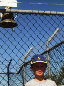
Photograph, Anne Macarthur, Tom and Toby Macarthur at New Works Lakes Entrance Victoria, 1/01/2013 12:00:00 AM
Colour photographs showing Tom and Toby Macarthur standing beneath the Flagstaff bell at New Works Lakes Entrance Victorianavigation, people -
Lakes Entrance Historical Society
Book, D W Paterson, Collins Street Directory 1936, 1936
Book of maps showing street directionsBook of mapsnon-fictionBook of maps showing street directionsnavigation, local history -
 Flagstaff Hill Maritime Museum and Village
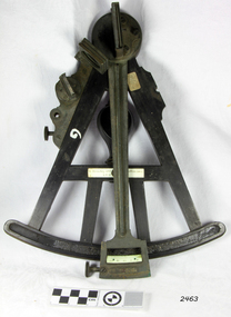
Octant, Late 18th to mid-19th century
An Octant is a doubly reflecting navigation instrument used primarily by sailors to measure the angular distance between two visible objects and was a forerunner of the sextant. The name comes from the Latin octo, or “one-eighth of a circle,” for the Octant’s arc which spans 45°, or one-eighth of a circle. The primary use of an Octant is to measure the angle between an astronomical object and the horizon for the purposes of celestial navigation. The estimation of this angle is known as sighting or shooting the object, or taking a sight. The angle, and the time when it was measured, can be used to calculate a position line on a nautical chart (latitude), for example, sighting the Sun at noon or Polaris at night (in the Northern Hemisphere) gives an angle by which the latitude can then be estimated. Sighting the height of a landmark on land can also give a measure of distance. History: The principle of the Octant as an instrument to measure ones latitude was first implemented around 1742-present but was superseded by the improvement of the octant to a sextant, a very similar instrument, better made and able to measure bigger angles 120°, allowing the measurement of Luna distances to give longitude when used with an accurate chronometer. The sextant started to appear around 1730 and had been attributed to by John Hadley (1682–1744) and Thomas Godfrey (1704–1749), but reference to the sextant was also found later in the unpublished writings of Isaac Newton (1643–1727). Earlier links can be found to Bartholomew Gosnold (1571–1607) indicating that the use of a Sextant for nautical navigation predates Hadley's implementation. In 1922, the sextant was modified for aeronautical navigation by Portuguese navigator and naval officer Gago Coutinho. Henry Hemsley was a lesser-known instrument maker and optician working in London in the late 17th and early 18th century. However, it should be noted that there were two Henry Hemsley opticians and instrument makers around this period. (Henry Hemsley 1, 1786-89, who had premises at 85 Fleet St London and Henry Hemsley 2, 1828-56), whose workshop was at 135-138 Radcliff Highway London. Therefore, based on the inscribed workshop address Henry Hemsley 2 is responsible for making this example.The octant is representative of its type and although not fully complete it demonstrates how 18th and 19th-century mariners determined their latitude on a chart to navigate their way across the world's oceans in the 18th and 19th century. It also demonstrates the skill and workmanship of the early instrument makers that operated from London at this time and provided most of the navigational instrumentation use by commercial and military navies of the time.Octant, ebony wooden frame and handle. Scale is missing from recess in frame. "H. Hemsley 135-138 Ratliff Highway, London", no box"H. Hemsley 135-138 Ratcliff Highway, London"flagstaff hill, warrnambool, shipwrecked-coast, flagstaff-hill, flagstaff-hill-maritime-museum, maritime-museum, shipwreck-coast, flagstaff-hill-maritime-village, navigation, navigational instrument, instrument used for navigation, sextant, henry hemsley, instrument maker, london, octant -
 Flagstaff Hill Maritime Museum and Village
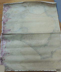
Document - Chart, Admiralty Office, Port Phillip, 1899
Accurate charts were imperative for sea farers to sail their vessels safely from one side of the world to another. The British Admiralty published many charts and updated them frequently. Specialists were employed to gather information such as depth soundings to give the navigator as many helps as possible. At regular intervals the charts had to be updated with the amount of adjustment needed to a compass to allow for magnetic variation.This chart is significant for its association with incoming and outgoin ships for trade and passengers in the late 19th century.Admiralty Chart of Port Phillip, Victoria, South Coast of Australia. It shows navigation buoys, lighthouses, tides and money other details. It was surveyed by Commander Henry L. Cox R.N. in 1864. Published by Admiralty August 19th 1865. Corrections were made by Staff Commander E.J. Stanley R.N. in 1874. The West Channel was surveyed b J.B. Mason , Engineer, in 1899. Published and cartographed in Admiralty, London, England in 1897, supervised by Capt G H Richards R N Hydrographer. Chart was updated in 1899. Sold by W D Potter Agent for Admiralty Charts 145 minorities.Printed: "Port Phillip" "Australia - South Coast, Victoria"flagstaff hill, warrnambool, maritime-museum, flagstaff hill maritime museum & village, shipwreck coast, chart, australia, south coast, port phillip, admiralty, 1899, navigation, cartography, cartographer -
 Bendigo Military Museum
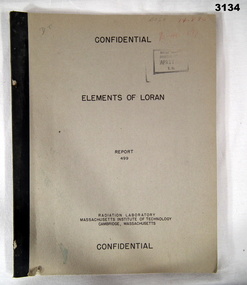
Manual - RADIO NAVIGATION, Radiator Laboratory, Massachusetts Institute of Technology, Elements of LORAN, Report 499, 1944
LORAN is a radio navigation system.Marked Confidential. Khaki coloured soft cover book with black print. Illustrated with drawings, charts, mathematics, 45 pages.Some random numbers written on front top right.books reference/military/manuals, radio -
Glenelg Shire Council Cultural Collection
Functional object - Lamp - Navigational, c. 1983
ex-'Tarragal', tug boat, Port of Portland|Port of Portland Authority CollectionFront: Seahorse/ G. B./ 59676 (on lid) PORT Back: (no inscriptions)port of portland archives -
 Ringwood and District Historical Society
Newspaper - Newspaper Cutting, City of Ringwood, Victoria - opening of Wonga Road Tip by the council - 1973
Newspaper cutting from "The Mail" Wednesday July 25 1973 announcing the opening of Wonga Road Tip by the council. A.W. Hall, Town Clerk. (Accompanying map lacks readable navigation reference points/street names.) -
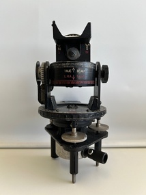 Moorabbin Air Museum
Instrument (item) - Astro Compass A.M (Air Ministry) MKII 6.A/1174
A.M Astro Compass MKII 6.A/1174 2 x -
 Bendigo Military Museum
Accessory - INSTRUMENT - NAVIGATIONAL AID
Navigational aid used during WW11Instrument for altitudes & air speed corrections. Notebook with spiral binding attached inside.Scratched on inside of stainless steel surface of cover: A G Culvenor 46 Station St. Nunawading instruments, military history - airforce, aviation, mechanics