Showing 937 items matching " reservoir"
-
 Eltham District Historical Society Inc
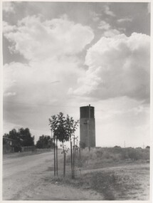
Photograph - Digital Photograph, Alan King, Maroondah Aqueduct Siphon Bridge over the Plenty River, 26 January 2008
Opened in 1891, the bridge formed part of the Maroondah Aqueduct carrying water from Watts River near Healesville to the reservoir at Preston where it joined Melbourne's metropolitan water system. Covered under Heritage Overlay, Nillumbik Planning Scheme. Published: Nillumbik Now and Then / Marguerite Marshall 2008; photographs Alan King with Marguerite Marshall.; p99 Built to supply thirsty Melbourne in the late 19th century, the siphon bridge spanning the Plenty River off Leischa Court, Greensborough, was part of an engineering masterpiece. Opened in 1891, the bridge formed part of the Maroondah Aqueduct carrying water from the Watts River near Healesville to the reservoir at Preston where it joined the metropolitan distribution system. A major link in Melbourne’s water supply, it also had a huge impact on communities, which mushroomed along its route. Named after the Aboriginal word for the area around the Maroondah Reservoir, the Maroondah Aqueduct was fully operational until the 1970s. Since the 1980s the land along parts of the aqueduct have been used for walking and bicycle riding, shaded in places by Monterey Pine trees planted to stabilise the surrounding ground. From 1857 the Yan Yean Reservoir supplied Melbourne’s water but the growing city needed additional catchments.1 In 1886 work began on a weir on the Watts River to enable the aqueduct to carry most of the river water 41 miles (66km) to Melbourne. The aqueduct, built by the Board of Works, is the oldest remaining aqueduct near Melbourne and was probably the first built with concrete.2 Although the aqueduct is now only used between the Maroondah and Sugarloaf Reservoirs, it can still be traced across the Shire. It extends from the Maroondah Reservoir through Christmas Hills, Kangaroo Ground, Research, Eltham, St Helena and then previously wound west through Greensborough to Reservoir.3 Built by horse and manpower the aqueduct gravity fed 25 million gallons (113.6ML) of water a day to Melbourne along a gradient of one foot to the mile. It included 25 miles (41km) of open concrete and brick channel, six miles (10km) of tunnels, and nine miles (15km) of 14 inverted siphons of riveted wrought-iron across creeks. Bricks for the aqueduct were made from clay found near the sites and remains of several kilns can still be found between Kangaroo Ground and Christmas Hills. Building the aqueduct transformed local communities. An abattoir was established at Christmas Hills. Grog shanties and labourers’ camps sprang up and local courts dealt with cases of ‘petty pilfering and boisterous behaviour’.4 The Kangaroo Ground school population jumped to 91, crammed into a room with one teacher. Miners who built the tunnels camped just north of Churinga in Greensborough – then called Tunnel Hill Camp – and adjacent to the Evelyn Arms Hotel. The miners’ high spirits were sometimes quenched in horse troughs or by a ‘welt under the ear and kick on the behind’ as the local constable calmed them down rather than lock them up.5 But the growing city of Melbourne needed more water, so the O’Shannassy catchment, east of Warburton, was added to the system in 1914. In 1920 work began on the present concrete Maroondah Dam one mile (1.6km) from the weir on the Watts River. The aqueduct capacity was thus doubled to 50 million gallons (227ML) a day.6 Intense land development threatened to pollute the open water supply, so channel sections were replaced with large pipes. In the late 1960s a large water main was built from the tunnel outlet at Research and extended through St Helena and Greensborough, so this section of the aqueduct was taken out of use. Long sections of the unused open channels in Greensborough and Bundoora were destroyed, but the old channel in Research and Eltham North remained largely intact. In the 1970s, the Sugarloaf Reservoir was constructed, inundating 445 hectares of land in Christmas Hills. Sugarloaf was officially opened in 1980 and serves as a water storage and treatment plant supplying Melbourne. In the early 1980s pipes replaced the section from Sugarloaf Reservoir to the tunnel entrance at Kangaroo Ground. The Research-Kangaroo Ground tunnel operates as part of the pipeline system.This collection of almost 130 photos about places and people within the Shire of Nillumbik, an urban and rural municipality in Melbourne's north, contributes to an understanding of the history of the Shire. Published in 2008 immediately prior to the Black Saturday bushfires of February 7, 2009, it documents sites that were impacted, and in some cases destroyed by the fires. It includes photographs taken especially for the publication, creating a unique time capsule representing the Shire in the early 21st century. It remains the most recent comprehenesive publication devoted to the Shire's history connecting local residents to the past. nillumbik now and then (marshall-king) collection, maroondah aqueduct, pipe bridge, siphon bridge -
 Greensborough Historical Society
Map, Melbourne and Metropolitan Board of Works. Survey Division, MMBW, Yarra 2500 / 15.24. Diamond Creek, Grassy Flat Road, 1978_02
Melbourne and Metropolitan Board of Works. Yarra 2500 [base map] 15.24. Diamond Creek, Grassy Flat Road. Parish of Nillumbik 3310. Municipality of Diamond Valley 257. Prominent streets include: Everleigh Drive, Broad Gully Road and Clyde Street. Features include the Diamond Creek, Nillumbik Park and Diamond Creek Reservoir.MMBW Map in 1:2500 [scale] series. Cream parchment with green tape reinforcing on edges and punched holes on left edge.mmbw, melbourne and metropolitan board of works, diamond creek - maps, shire of diamond valley -
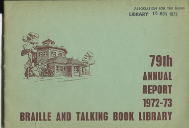 Vision Australia
Administrative record (item) - Text, National Information Library Service, 79th Annual Report 1972-73 Braille and Talking Book Library, 1973
Annual report of the Braille & Talking Book Library including Minutes of the AGM, Board of Director's Report, President's report and financial statements. Items also included are: the name change from the Braille Library of Victoria, the passing of Neil Westh and Mary Mitchell, the retirement of Miss Anderson and funds raised by the Sixty Niners, Reservoir and Altona auxiliaries.corporation records, braille and talking book library -
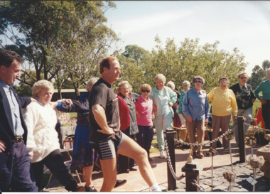 Melbourne Legacy
Photograph, Widows activities, 1995
Photograph of an outing for Legacy widows, with an instructor demonstrating gentle exercises in a garden. It was published in the June 1995 edition of The Answer with the details: "Preston/Reservoir Legacy Widows' Club. Members enjoyed a session of gentle exercise, a healthy meal and a beautiful day - all that was needed for a wonderful event at Bundoora Park last month. Sponsored by Veterans Promotions Department."A record of one of the many activities arranged by the Widows Clubs.Colour photo of a widows' outing in 1995.widows, exercise classes, activities, answer -
 Bendigo Historical Society Inc.
Photograph - Nell Gwynne Gold Mine site, 1934
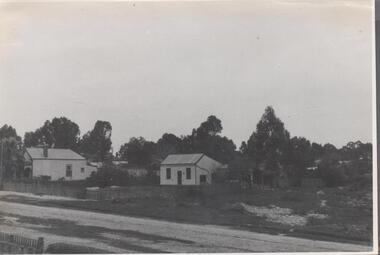
The Nell Gwynne mine site was within the Spring Gully Water Reserve, north west of the reservoir near Diamond Hill Road. An abridged prospectus for the Nell Gwynne (B.M.L.) No Liability, was published in the Sun News Pictorial on 7th June 1934, page 26 (Advertising).https://trove.nla.gov.au/newspaper/article/277316940?searchTerm=napoleon%20bmlSignificant to mining history of Bendigo.Black and white photograph of two weatherboard houses in bush setting. Gravel road in foreground. Written in pencil on back of photograph in pencil: 'Nell Gwynne 25.9.34'nell gwynne gold mine -
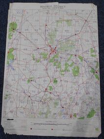 Bendigo Historical Society Inc.
Map - Bush Fire Control Map Bendigo District
A Bush Fire Control map is a valuable tool used by emergency services and communities to respond to respond to bushfires.Cream coloured parchment map showing roads, railway lines, telephone lines, rivers, creeks and water courses. Also marked are houses, Post Offices, Police stations, bush fire brigades, water channels, swamps, marshes, dense, medium and scattered timber, aqueducts and reservoirs. Villages, districts and Towns are clearly marked. Printed in red, green, black and blue. Very clear and easy to read. Undated.bush fires, bendigo area map -
 Bendigo Historical Society Inc.
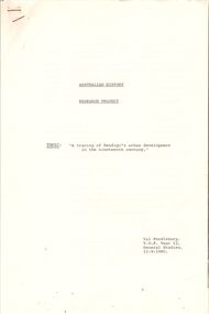
Document - RESEARCH PROJECT: A TRACING OF BENDIGO'S URBAN DEVELOPMENT IN THE 19TH CENTURY, 12/09/1980
(''A tracing of Bendigo's urban development in the 19th century'') - a 9 paged Research Project; Australian History; T.O.P. Year 12 General Studies; author - Val Pendlebury; 12/9/1980. Reference to: Henry Carey Bennett; Howards Coaches; Camp Street; Auction Street; Captain Andrew Clarke; Theatre Royal; William Larritt; Municipal Council; Bendigo Water Works Company; Big Hill reservoir; Vahland. Bibliography.Val Pendleburybendigo, history, 19th century bendigo, henry carey bennett, howards coaches, camp street, austion street, theatre royal, municipal council, bendigo water works. big hill reservior, vahland. william larritt. -
 Bendigo Historical Society Inc.
Map - HARCOURT : COUNTY OF BENDIGO, December 1951
Map. Harcourt, County of Bendigo, County of Talbot, Ravenswood. Sutton Grange, Walmer, Castlemaine, Faraday, Calder Highway, Northern Railway, Town of Harcourt, Barkers Creek, Victorian Water Supply Res., in connection with Barkers Creek Reservoir. By authority J.J. Gourley, Government Printer, Melbourne .Drawn and reproduced at the Department of Lands and Survey, Melbourne. December 1951. Price 2/- per sheet. (number 96 in map cupboard 1)J.J. Gourley, Government Printer, Melbourne.map, bendigo, harcourt -
 Bendigo Historical Society Inc.
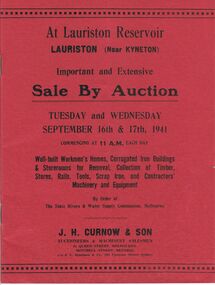
Document - MCCOLL, RANKIN AND STANISTREET COLLECTION: LAURISTON RESERVOIR AUCTION, September 16th/17th 1941
Catalogue of Sale By Auction of buildings, timber, stores, rails, tools, scrap iron, and contractors machinery and equipment. Auction to be held Tuesday and Wednesday September 16th and 17th , 1941. By order of the State Rivers and Water Supply Commission, Melbourne. J. H. Curnow & Son, Auctioneers & Machinery Salesmen, 31 Queen Street, Melbourne 3000 and Mitchell Street Bendigo Victoria 3550. To be held at Lauriston reservoir, Lauriston (near Kyneton).J.H. Curnow & Son, 31 Queen Street Melbourne.government, state, lauriston reservoir -
 Eltham District Historical Society Inc
Slide, Maroondah Aqueduct, Research, Victoria, 22 Mar. 1981
An inspection tour of the Maroondah Aqueduct was undertaken by the Shire of Eltham Historical Society on Sunday, March 22nd, 1981, commening where the aqueduct crosses Main Rd., Research, just below Eltham College. The Maroondah Aqueduct was part of Melbourne’s water supply system. It carried water over the 66 km from the Maroondah Reservoir on the Watts River at Healesville to the Preston Reservoir. Of this length, 41 km were open channel, 10 km, tunnel through hills and 15 km in 14 inverted siphons across stream valleys. The route of the aqueduct is north of Tarrawarra and Yarra Glen, along the Yarra escarpment south of Christmas Hills and crossing Watsons Creek into the present Shire of Eltham near Henley Rd. The eastern part of the route lies entirely within the former boundaries of the shire. The aqueduct passes south of Kangaroo Ground to Research and crosses the Diamond Creek by siphon at Allendale Rd., Eltham North. It then extends to Reservoir via St. Helena, Greensborough North and Bundoora. Water first flowed through the aqueduct in February 1891 when it was fed by a diversion weir on the Watts River. Records of the building of the aqueduct indicate that it was a significant construction achievement. The present Maroondah Reservoir was completed in 1927 and the aqueduct was enlarged at that time to take increased flows. About 1971 the section of the aqueduct through and north of Research was replaced by a large pipe and that section of the channel is now unused. The channel has remained largely intact (unlike sections at Greensborough and Bundoora where long lengths of the disused aqueduct have been demolished or filled in). The M.M.B.W. relinquished control of the disused aqueduct reserve which is crown land and the Shire of Eltham took control of this section of the reserve as a linear park. The Maroondah Aqueduct is considered to be an important historic structure, not just to the local area but to the metropolitan area generally. It is considered important to preserve substantially intact long lengths of the disused aqueduct, together with its bridges and other associated structures. 35 mm colour positive transparency (1 of 5) Mount - Agfachrome Agfa CS System black 8 dotsactivities, heritage excursion, maroondah aqueduct, research (vic.), shire of eltham historical society -
 Greensborough Historical Society
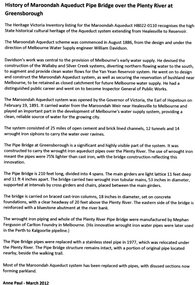
Article, Anne Paul, History of Maroondah Aqueduct Pipe Bridge over the Plenty River at Greensborough, by Anne Paul, 2012_03
The Maroondah Aqueduct pipe bridge, opened in 1891, was an important part of the system carrying water from the Maroondah Reservoir near Healesville to Melbourne. Most of the original system has been replaced by stainless steel pipes, the Greensborough section now running under the Plenty River since 1977. The original pipe bridge can still be seen over the Plenty River at Greensborough.2 p. typescriptaqueduct pipe bridge greensborough, maroondah aqueduct, melbourne water supply, anne paul -
 Rutherglen Historical Society
Images, 1960s
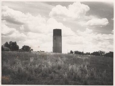
One of a collection of photographs from the Iggsten Estate. The water tower in the background is located in Hunter Street and was built in 1899-1900 to serve as the town's water supply. A new reservoir was built in 1945 with water being pumped from the Murray. A steel mesh structure, to make it look like a wine bottle, was added to the top in 1969 with funds from the Rutherglen Wine Festival.Black and white photograph, taken from the bottom on a hill, showing a water tower against the sky.water tower, wine bottle, tourism -
 Rutherglen Historical Society
Images, 1960s
One of a collection of photographs from the Iggsten Estate. The water tower in the background is located in Hunter Street and was built in 1899-1900 to serve as the town's water supply. A new reservoir was built in 1945 with water being pumped from the Murray. A steel mesh structure, to make it look like a wine bottle, was added to the top in 1969 with funds from the Rutherglen Wine Festival.Black and white photograph of a water tower, at the top of a hill, silhouetted against the sky.water tower, wine bottle, tourism -
 Rutherglen Historical Society
Images, 1960s
One of a collection of photographs from the Iggsten Estate. The water tower in the background is located in Hunter Street and was built in 1899-1900 to serve as the town's water supply. A new reservoir was built in 1945 with water being pumped from the Murray. A steel mesh structure, to make it look like a wine bottle, was added to the top in 1969 with funds from the Rutherglen Wine Festival.Black and white photograph, taken from the bottom on a hill, showing a water tower against the sky.water tower, wine bottle, tourism -
 Vision Australia
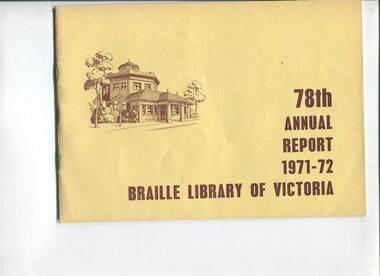
Administrative record - Text, 78th annual report 1971 - 1972 Braille Library of Victoria, 1972
Articles include the addition of a talking book service to the library, 50 years of service celebrations for Alice McClelland, a talking book funds sub-committee has been convened, a planning sub-committee has also been created to evaluate the future needs of the Library in the next 5-10 years, and the Reservoir, Altona, Sixty-Niners and Benalla Auxiliaries continue to raise funds.25 pages of text with drawingsbraille library of victoria, corporation records -
 Bendigo Historical Society Inc.
Document - BROCHURE 'STEAM-O-MATIC' PACKAGED BOILERS
Orange, green and white two page brochure: on front ' packaged power perfection with George & George Pty Ltd., ' Steam-o-matic' packaged boilers. Bottom right hand corner '25 Plateau Road, Reservoir, Vic. Phone JM 2570-2571' Photo of steam boiler on front and back of brochure. Annotated photo on back e.g. copper balancing tank ensures feed water tank remains full at all times'organisation, commerce, george & george pty ltd. -
 Federation University Historical Collection
Postcard - Images, Views of Ballarat, c1920
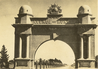
Six small black and white postcards depicting views of Ballarat. .1) Sturt Street Gardens Ballarat, c1920 .2) Gong Gong Reservoir, Ballarat, c1920 .3) Sturt Street, Ballarat, c1920 .4) Sturt Street, Ballarat, c1920 .5) Sturt Street Looking Towards Mount Warrenheip, Ballarat, c1920 .6) Ballarat Arch of Victory, Ballarat, c1920. This view shows newly planted trees in the Ballarat Avenue of Hunour. ballarat, sturt street, sturt street gardens, mt warrenheip, trams, gong gong reservoir, ballarat arch of victory, gallaway memorial, galloway fountain, ballarat avenue of honour, harry davies, arch of victory, harry davies and co, ballaarat mechanics' institute, st andrew's kirk -
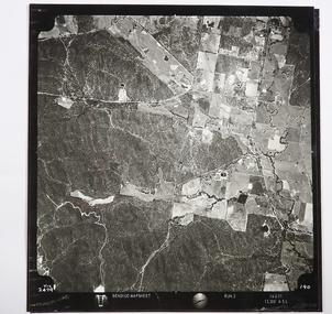 Bendigo Historical Society Inc.
Map - CAMPBELL COLLECTION: BENDIGO AND DISTRICT MAPS
Map. Two aerial photographs of Kangaroo Flat and Lockwood (part). Crusoe Reservoir bottom right corner on Crusoe Road, shows Merindah Road running between Lockwood and Crusoe Roads. Map Name : Bendigo Mapsheet Run 2. 14-2-71, 13,200 A.S.L.. Map shown with NORTH at bottom of page, VIC 2479 at corner. Map 2 continues to the west. A joined copy of both photographs is also included.map, bendigo, agricultural lands -
 Bendigo Historical Society Inc.
Slide - HORWOOD COLLECTION: CHEWTON WATER WHEEL, c1965
The Garfield water wheel was the largest ever constructed in Victoria, standing 22 metres tall. Water was brought via a race from the Expedition Pass Reservoir and passed through the water wheel to power a 23 head stamping battery. This was all part of the Garfield Mining Company established in 1882. The wheel was in operation from 1887 to 1903 and was dismantled in 1904, leaving the stone supports still standing.Horwood Collection - Chewton Water Wheel. The support for the water wheel at Chewton. Markings; Water Wheel - Chewton DEC65MKodakmine, gold, chewton water wheel, horwood collection - chewton water wheel. the support for the water wheel at chewton -
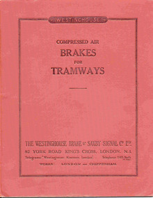 Ballarat Tramway Museum
Book, Westinghouse Brake & Saxby Signal Co. Ltd, "Compressed Air Brakes for Tramways", May. 1929
Forty One page book with dark red cover titled "Compressed Air Brakes for Tramways", published by Westinghouse Brake and Saxby Signal Co. May 1929. Cover - cloth texture laminated paper cover, dark red on outside, with embossed title and publishing details and Westinghouse logo embossed on rear cover. Forty printed pages sewn at three points into cover with page 41, tipped onto right hand edge of page 40, with a blind perforated strip to enable the sheet to be used as an Enquiry form to obtain a price regarding tram brake equipment. Covers compressed air brake systems in general for tramways, including layout drawings, straight air brake, braking ratio, brake cylinder sizing, reservoirs, air compressor type E13, DH16, E13, Governors ES16, Brake Valve No. 13, 9, brake cylinder, sand ejectors, reservoirs drain cocks, with an appendix describing the automatic brake system for use with trailers. Manual No. DP12."Colin Rutledge" stamped on top of page 1.trams, tramways, westinghouse, tramcar brakes, compressors, governors, equipment -
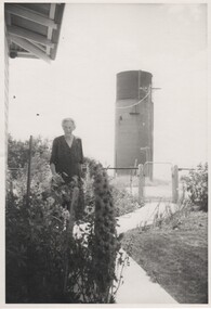 Rutherglen Historical Society
Images, 1960s
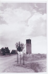
One of a collection of photographs from the Iggsten Estate. The water tower in the background is located in Hunter Street and was built in 1899-1900 to serve as the town's water supply. A new reservoir was built in 1945 with water being pumped from the Murray. A steel mesh structure, to make it look like a wine bottle, was added to the top in 1969 with funds from the Rutherglen Wine Festival. The woman in the photograph may be Florence Iggsten. Black and white photograph of a woman standing in a front garden, with a view of a water tower in the background.florence iggsten, water tower, wine bottle, tourism -
 Bendigo Historical Society Inc.
Map - LONG GULLY HISTORY GROUP COLLECTION: MAP OF REEFS AND MINES
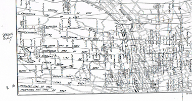
BHS CollectionTwo pages with lines of reef and mines from Spring Gully Reservoir to north of the Eaglehawk Railway Station. Shown on the map are the lines of reef, the Thistle, Carshalton, Napoleon, British & Foreign, Nell Gwynne, New Chum, Sheepshead, Deborah, Garden Gully, Paddy's Gully, Derby, Miller's, Hustlers, Lightning Hill, Myers Flat, Lancashire, Cook's, Maiden Gully, Johnson's and Millers. Also shown are the Golden Square, Bendigo and Eaglehawk Railway Stations as well as the hills.bendigo, history, long gully history group, the long gully history group - map of reefs and mines, spring gully reservoir, thistle, carshalton, napoleon, british & foreign, nell gwynne, new chum, sheepshead, deborah, garden gully, paddy's gully, derby, miller's, hustlers, lightning hill, myers flat, lancashire, cook's, maiden gully, johnson's, millers, golden square railway station, bendigo railway station, eaglehawk railway station -
 Bendigo Historical Society Inc.
Document - STATE RIVERS AND WATER SUPPLY COMMISSION : GENERAL DESCRIPTION AND PARTICULARS OF EPPALOCK PROJECT, 1/08/1961
State Rivers and Water Supply Commission. Seven-page typed document titled 'General description and particulars of the Eppalock Project.' Subheadings: General, Administration and Works Installation, Field laboratory, Construction programme, Design statistics, Major items of plant in use on the project, Progress to 1st August 1961, Eppalock Reservoir Locality Plan (diagram), Eppalock project works area & arrangement plan (diagram), Eppalock Project cross section of dam along? tunnel (diagram).state infrastructure, water supply, coliban system, state rivers and water supply commission. coliban system. eppalock. -
 Bendigo Historical Society Inc.
Document - KANGAROO FLAT GOLD MINE COLLECTION: FILE NOTE WESTERN MINING CORPORATION ON CENTRAL DEBORAH MINE
Four page file note written by J.O. Reynolds, WMC, on 5th September, 1980, re meetings held by J Reynolds, H.Hooker and F.B. Taylor with Roger Wright at his drilling operations at Wilson Hill and Spring Gully reservoir. They also met with Daryl McClure, MLA Bendigo and Doug Cahill, solicitor, at WMC's Bendigo exploration office. The Central Deborah Tourist Mine development with the Bendigo Trust and Bendigo Mining NL interest in the development of the mine as a producing mine was discussed.bendigo, gold mining, central deborah gold mine, bendigo, goldfield, gold mining, j.o reynolds, tourism, bendigo trust, western mining corporation -
Bendigo Historical Society Inc.
Map - HARCOURT : COUNTY OF BENDIGO, 23-3-10
Map. County of Bendigo, County of Talbot, Sutton Grange, Ravenswood, Walmer, Faraday, Castlemaine, Axe Creek, Barkers Creek, Melbourne to Echuca Railway, Victorian Water Supply in Connection with Barkers Creek Reservoir. Victorian Water Supply Reserve, Mt. Alexander State Forest. Three areas reserved for Sericulture (Silkworms). Photo-Lithographed at the Dept. of Lands and Survey, Melbourne by T.F. McGauran 23-3-10. Price 1/-. (number 101 in map cupboard 1)T.F. McGauranmap, bendigo, harcourt -
 Bendigo Historical Society Inc.
Photograph - Historical Society Field Trip to the Springs at Sedgwick, Abt 2009
The Phil Wilkin Collection contains a series of 11 Items. The related items can be found by clicking on the reference link below. The following history of the Young family and their descendants who lived at the Springs is provided by Phil Wilkin. His Great Grandparents were Frances Young and August Wirth. Phil has also provided notes on the Wilkin Family and some history of the gold mining in Sedgwick. Frances Young's parents Joseph and Margaret Young owned the property called "The Old Place, Preston Vale or Wellington Flat" at Sedgwick near the Springs. Joseph Young owned and Managed the Standard Brewery which was located at Campbells Creek during the late 1800’s early 1900’s. Joseph and Margaret are buried in the Harcourt cemetery. In 1880 August Wirth lived at Mosquito Creek (Lake Eppalock, Victoria) when he married Frances Young. In 1902 they moved to part of Joseph Young's property. They milked cows and sold cattle for a living. One of their children Charles Wirth (Phil Wilkin's Grandfather) bought the land in 1935 after his parents had died. Charles Wirth was a councillor and also was president of the Shire of Strathfieldsaye. The "Old Place" was part of the property owned by members of the family. The old house at the Springs was burnt out by bushfire in January 1944 and much of the stonework was later vandalized by campers. The original Coliban Water Works were designed in 1863 by the Irish engineer Joseph Brady. The system included 70 kilometres of open water channels, aqueducts, syphons and tunnels to carry water (by gravity) from the Coliban River at Malmsbury, north to Castlemaine and Bendigo. Sedgwick is a locality in Central Victoria, Australia. It is located in the City of Greater Bendigo. Facilities include a public hall that opened in 1958 and CFA Rural fire station. It was named Upper Emu Creek until 1901 when it was renamed as Sedgwick after British geologist Adam Sedgwick.Twenty nine photos taken on a field trip by the Bendigo Historical Society to "The Springs" on the main Coliban water channel from Malmsbury to the Sandhurst Reservoir in Bendigo. The water race descends through a concrete chute, and continues sharply around the contour of the hills. Once it descended into a syphon across the gully. The are 182 photos in this series and can be found at 8683.1 to 8683.11. The series also includes photos of the surrounding farming land and the remains of an old house. There are also some notes on the pioneers of the district.history, bendigo, coliban water, joseph brady, irrigation, the springs, sedgwick -
 Bendigo Historical Society Inc.
Photograph - Historical Society Field Trip to the Springs at Sedgwick, Abt 2009
The Phil Wilkin Collection contains a series of 11 Items. The related items can be found by clicking on the reference link below. The following history of the Young family and their descendants who lived at the Springs is provided by Phil Wilkin. His Great Grandparents were Frances Young and August Wirth. Phil has also provided notes on the Wilkin Family and some history of the gold mining in Sedgwick. Frances Young's parents Joseph and Margaret Young owned the property called "The Old Place, Preston Vale or Wellington Flat" at Sedgwick near the Springs. Joseph Young owned and Managed the Standard Brewery which was located at Campbells Creek during the late 1800’s early 1900’s. Joseph and Margaret are buried in the Harcourt cemetery. In 1880 August Wirth lived at Mosquito Creek (Lake Eppalock, Victoria) when he married Frances Young. In 1902 they moved to part of Joseph Young's property. They milked cows and sold cattle for a living. One of their children Charles Wirth (Phil Wilkin's Grandfather) bought the land in 1935 after his parents had died. Charles Wirth was a councillor and also was president of the Shire of Strathfieldsaye. The "Old Place" was part of the property owned by members of the family. The old house at the Springs was burnt out by bushfire in January 1944 and much of the stonework was later vandalized by campers. The original Coliban Water Works were designed in 1863 by the Irish engineer Joseph Brady. The system included 70 kilometres of open water channels, aqueducts, syphons and tunnels to carry water (by gravity) from the Coliban River at Malmsbury, north to Castlemaine and Bendigo. Sedgwick is a locality in Central Victoria, Australia. It is located in the City of Greater Bendigo. Facilities include a public hall that opened in 1958 and CFA Rural fire station. It was named Upper Emu Creek until 1901 when it was renamed as Sedgwick after British geologist Adam Sedgwick.Twenty five photos taken on a field trip by the Bendigo Historical Society to "The Springs" on the main Coliban water channel from Malmsbury to the Sandhurst Reservoir in Bendigo. The water race descends through a concrete chute, and continues sharply around the contour of the hills. Once it descended into a syphon across the gully. The are 182 photos in this series and can be found at 8683.1 to 8683.11. The series also includes photos of the surrounding farming land and the remains of an old house. There are also some notes on the pioneers of the district.history, bendigo, coliban water, joseph brady, irrigation, the springs, sedgwick