Showing 885 items
matching road crossing
-
 Eltham District Historical Society Inc
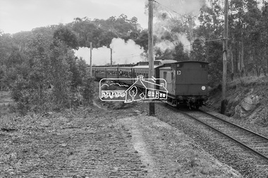
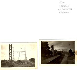
Photograph, George Coop, Vintage train excursion hauled by steam locomotive K-190 en route to Hurstbridge near the level crossing at Allendale Road, Eltham, 3 July 1983, 1983
... route to Hurstbridge near the level crossing at Allendale Road...allendale road, k-190, level crossing, red rattler, steam... melbourne allendale road, k-190, level crossing, red rattler, steam ...Digital TIFF file Scan of 35mm Ilford FP4 black and white transparencyallendale road, k-190, level crossing, red rattler, steam engine, tait train -
 Eltham District Historical Society Inc
Photograph, Looking east from the northern side of Lower Plenty Road (opposite Bannockburn Road) as it crosses the Watsonia Drain, Viewbank, c.1965, 1965c
Transmission power lines visible in distance behind the Lower Plenty Hotel (in centre upper) and parts of Heidelberg Golf Club. In the foreground a bulldozer can be seen commencing roadworks for the re-alignment of Lower Plenty Road for the new Lower Plenty Bridge crossing.Medium format 120 6x6 black and white negative film, 1 frameheidelberg golf club, lower plenty, lower plenty hotel, road construction, viewbank, watsonia drain -
 Eltham District Historical Society Inc
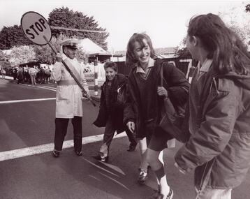
Photograph, Fred Mitchell, Dalton Street School Crossing sign on Main Road, Eltham, 1966, 1966
... Dalton Street School Crossing sign on Main Road, Eltham... Crossing sign on Main Road, Eltham, 1966 Photograph Fred Mitchell ...Digital copy of colour photographfred mitchell collection, 1966, dalton street, eltham, main road -
 Eltham District Historical Society Inc
Photograph, Wattletree Road Bridge over the Diamond Creek, Eltham, February 1990
Just prior to redecking the bridge in February 1990Roll of 35mm colour negative film, 4 stripsFuji 100crossings, diamond creek, eltham, eltham north, wattletree road, bridges -
 Glen Eira Historical Society
Newspaper - GLENHUNTLY
... ) about the beautification of the Koornang Road Shopping Centre... Hardware Hardware Stores Liberal Party Railway Crossings North Road ...This file contains one item pertaining to Glenhuntly: 1/A copy of the 11/1981, Vol. 1, No. 1 edition (that is, the first edition) of the Glenhuntly News, a local newspaper. Each of its 8 pages except pages 6 and 8 contain material of relevance to Glen Eira. Page 1 features 3 items: an article about the action taken in the wake of a fire occurring at Glenhuntly Primary School on 29/10/1981, a short article about Caulfield resident’s misuse of rubbish bins, and an article (continued on page 7) about the beautification of the Koornang Road Shopping Centre. Page 2 features 2 items: an advertisement for Homestead Handyman Hardware, and an article in which the Liberal candidate for the seat of Glenhuntly, Peter Norman, comments on the State Government’s decision not to extend trading hours for large retailer. Page 3 features 4 items: 2 advertisements for volunteer work for the regional branch of the Liberal Party, an article about the many difficulties people face using an underpass at a railway crossing in North Road, and an article describing the aims of the newly-established newspaper itself. Pages 4 and 5 feature 1 item: an article about Peter Norman; his life, work and opinions. Page 6 features 1 item: an article(continued on page 7) by three American children – Anita, Fabos and Adrian (surnames unspecified) – detailing their visit to Melbourne. There does not appear to be anything of relevance to Glen Eira. Page 7 features 5 items: the continuations of the articles from pages 1 and 6, an advertisement for a pool party for young Caulfield/Glenhuntly Liberals, an advertisement for an antiques sale, and an article about the establishment of a technical school on the site of former Holmesglen Construction Factory in Malvern (not relevant to Glen Eira). Page 8 features 2 items: an article about the three certificates the Royal Life Saving Society of Australia offers children for swimming competency, and an advertisement for an automobile called the Gemini Sandpiper II. Neither is relevant to Glen Eira). Numerous black and white photographs throughout the newspaper illustrate the subjects at hand.‘glenhuntly news’, glenhuntly primary school, primary schools, fires, dolphin bill, st anthony’s school, dalton des, caulfield south primary school, gardenvale central primary school, norman peter, rubbish bins, koornang road shopping centre, carnegie neighbourhood study, car parks, caulfield city council, homestead handyman hardware, hardware stores, liberal party, railway crossings, north road, ormond railway station, strong chris mr., kendall press, norman carol, ormond east primary school, norman stuart, norman cameron, estrella kindergarten, solway primary school, higgins electorate committee, higgins area finance committee, national stationers and office suppliers association, oakleigh chamber of commerce, anti-c3 action group (actag), haywood don, ireland jim, ramsay jim, gardner barry, sessler kurt, thompson lindsay, booran holden, glenhuntly road, caulfield -
Glen Eira Historical Society
Article - MCKINNON
Brief typed history of McKinnon settlement taken from Moorabbin A Pictorial History 1862-1994 by John Cribben. Includes photocopied pages of railway gates, five land estate flyers and an article from the McKinnon Progress, undated.mckinnon, cribben john, crop production, markets, farmers, elster creek, mcmillan archibald, thomas street, centre road, wheatley road, vineyards, south road, ormond, brighton, moorabbin, irish, immigrants, bentleigh, priests, hanrahan pierce, hanrahan johanna, caroll michael, caroll catherine, howes eliza, howes john, howes edward, shanahan denis, shanahan ellen, gould james, gould catherine, howes george, bignell road, jasper road, tucker road, mcguiness family, quinn family, halinan family, malane family, inns, the gardeners arms, mckinnon hotel, bent james, bent thomas, tickets of leave, murray road, were nicholas, sargood family, ripponlea, mansions, elsternwick, st. stephens’ common school, church of england, school houses, evelyn street, st. john’s anglican church, telegraph offices, post offices, state schools, manchester road, north road, nicholls buildings, rivers frank, rivers ray, shops, pridgeon mr., elm grove, sobrin mr., clark misses, greaves bakery, armitage mrs., rout mr., tunnicliffe mrs., lance’s milk bar, johnson’s hardware shop, stiringer mrs., white horrie, robinson’s, mcinnerney’s flower shop, jean darling’s cakes, wyles jim, mckinnon progress association, glen orme avenue, ormond theatre, theatres, lester harry, the plaza, railway crossing, railway gates, wright street, nichols l., builders, pine grove, halls, st. elmo estate, patterson station estate, patterson road, brewer road, purton road, clee hill estate, railway park, hawthorn grove, wattle grove, elm grove, learys estate, manchester road, selkirk avenue, masters estate, lancaster street, moylan street, moorabbin railway crossing -
 Glen Eira Historical Society
Document - Theobald, Augustus ‘Gus’
This file contains three items about Theobald, Augustus Gus. One page type-written document title CAULFIELD IDENTITIES on the history of Gus Thoebald. The summary of it is published in the nineteenth newsletter (April 1982) of Caulfield Historical Society. Original newspaper cutting from THE AGE dated 20/08/1990, a sports article remembering Augustus Gus Theobald at the V.A.A. mens cross-country championship held on 18/08/1990. He was killed in a road accident at 93. Two original black and white photographs of Gus Theobald as a school-crossing supervisor at O’Neil campus in Garden Vale, undated.caulfield, glen huntly, theobald gus, theobald augustus albert, glen huntly road, royal avenua, electrical business, glen huntly athletic club, medals, sport, sports people, school crossing supervisor, death and dying, castella nick de, ryan gerard, lubofsky jon, deveson glen, hoyle adam, theobald augustus gus, ramadge col. -
 Glen Eira Historical Society
Photograph - Glen Huntly Railway Station
... Mermosa Road Railway Crossings Railway Lines Public Transport ...This file contains one item. 1. Eleven Photographs of Glen Huntly Railway Station, five in black and white, and six in colour. They date from the earlier part of the 20th century as well as into the 1980’s. One black and white photograph has ‘first electric train?’ handwritten on the back. Another has been taken from an advertisement for the auction of Madden Estate featured in the Prahran Telegraph dated 20/09/1913.glen huntly station, glenhuntly station, railway stations, railways, railway gates, trains, glen huntly road, catherine road, mernda road, mermosa road, railway crossings, railway lines, public transport, madden estate, land sales -
 Federation University Historical Collection
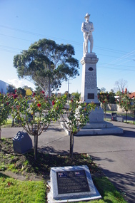
Photograph - Photograph - Colour, Alan Scarlett, Morwell War Memorial, 2015, 2015
... June 1921. The Memorial was originally the level crossing.... The Memorial was originally the level crossing between Commercial Road ...The Morwell War Memorial Morwell War was unveiled on 06 June 1921. The Memorial was originally the level crossing between Commercial Road and Station Street (later Princes Highway). It was later moved to its present position on the Princes Highway opposite Hoyle Street. (http://www.morwellhistoricalsociety.org.au/warmemorial.htm) Names Inscribed on War Memorial – World War 1 *Killed in action * Allis G. Francis J. Pettit H. Amiet C. Graur R. L. Pryor W. * Amiet F. D. Hall J. A. Pryke R. Anderson C. Hall S. D. Rowell F. Billingsley A. H. Hare Bert Rowe C. Butters C. * Handler P. Ronald A. Q Butters R. Hogan E. J. Rintoull W. G. (D.C.M.) Brown H. H. Kleine F. W. Saddler J. Brinsmead F. S. Whitelaw A. Smith C. Collins W. Whitelaw D. Symons H. Collins J. S. F. Keegan F. Thomas L. G. Cooper H. S. Little K. Thomas R. W. Capon W. V. Lock E. * Thomson R. H. Davey R. R. Lyons C. * Tulloch J. Davey E. W. Lyons R. P. Vunell C. R. E. Davey W. R. Miller F. Vinall H. V. Davey C. E. Maher A. Wood A. Duncanson J. Maher L. Wilkins F. Dusting C. * McIntosh A. Warnett J. * Dusting H. Neal A. E. Warnetyt W. H. Derham H. * O’Donnell T. Young J. A. World War 2 – Killed in action Allen H. A. Eason L. W. McDonald D. Angus C. P. Evans H. T. Muncaster J. Bolitho H. Ferguson R. W. Murray A. M. Bolton C. R. A. Gair N. Peter T. Bowden N. J. Green D. I. A. Read L. H. M. Brudge W. G. Hewat G, A, Roy E. W. Catterick J. H. Horsefall L. Sillcock R. R. Deanne A. Johnson F. Stagg J. L. Deering C. J. King L. S. Templer R. C. Doolan W. T. Lawrence F. E. Tienery R. Dickson L. H. McArthur D. Turner R. H. Williams R. K. Vietnam War – Killed in action Adrian RichColour photograph of a life sized Australian soldier wearing a slouch hat, on top of a large raised platform. A commemorative plaque is depicted in the foreground. The front inscription of the memorial reads: "This plaque was erected in memory of those who paid the Supreme Sacrifice in the Boer War [Names] Erected by the residents of Morwell riding as a tribute to the men resident in the riding who enlisted and in memory of those who made the Supreme Sacrifice in the Great War 1914-19 [Names] This plaque is erected in memory of those who paid the Supreme Sacrifice in World War II and Korea [Names] In affectionate remembrance of A. Rich R.A.R killed in action Vietnam 1962-72"The plaque in the foreground reads" "Centenary Commemoration Plaque This plaque commemorates 100 years since the first World War commended in 1914 and Australian and New Zealand (ANZAC) troops landed at Gallipoli on 25th April, 1915. Members of the Morwell RSL Sub-Branch will always remember the sacrifices made by service personal to give us the freedom we enjoy the this day. They Shall grow not old, as we that are left grow old Age shall not weary them, nor the years condemn At the going down of the sun and in the morning We will remember them Lest We Forget."morwell, morwell war memorial, world war one, anzac centenary, gippsland -
 Federation University Historical Collection
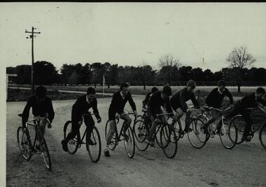
Photograph - Black and white photograph, Bike Ride - Ballarat Technical School students - 1950s
... "Ballarat 3" (miles). Second sign is train crossing sign for private... 3" (miles). Second sign is train crossing sign for private ....1 Black and white photograph of on bicycles. Sign on LHS "Ballarat 3" (miles). Second sign is train crossing sign for private road. .2 Riding on made road with channel dug beside. Farming area..1 "Ilford"; 1746 stamped. Hand written 9 .2 "Ilford"; 1748 stamped. Hand written 10bicycle, cyclist, ballarat junior technical school -
 Flagstaff Hill Maritime Museum and Village
Mast Collar, c. 1886
The husband of the donor of this mast collar chanced to be staying a night at a motel in Peterborough, along the Great Ocean Road in Victoria. He had a keen interest in maritime items and recognise the mast collar at the motel’s back fence line. The motel owner told his guest the story of a customer, a doctor, who had organised and paid for divers to raise the mast collar from a local shipwreck, the Falls of Halladale. Shortly afterwards the doctor passed away, so the mast collar had remained at the motel site. The owner was leaving the motel the following week and wasn’t at all interested in the artefact. He was very happy for his guest to remove it. It took five men to load the mast collar up for the trip to the new owner’s two storey shed in Ballarat. It stayed there undercover, in the company of his collection of 5 buggies, for the next 40 or so years until the property was for sale. A friend, who realised the significance of the mast collar, suggested that it be donated to Flagstaff Hill Maritime Village where other artefacts from the Falls of Halladale, such as the slate tiles, were on display. This mast collar, or masthead, from the Falls of Halladale would have been used to join two sections of one of the tall masts. As sailing ships became larger there was a need for taller masts or spars, which became difficult or impossible to find. To overcome this problem mast was divided into sections; lower and top or upper mast (on some of the ‘tall ships’ a mast could be divided into three or even four sections). The Falls of Halladale was a four-masted British barque built-in 1886. On what turned out to be her fatal journey, she had left New York for Melbourne in late 1908. She ran aground on a reef close to the shore west of Peterborough, South West Victoria, on November 14th. All 29 crew eventually landed safely onshore. The wrecked ship stayed on the reef for several months as locals watched the sails slowly deteriorate. The salvaged cargo included slate tiles, as mentioned above, and many of these have been used on the roof of buildings at the Flagstaff Hill Maritime Village. The iron-hulled, four-masted barque, the Falls of Halladale, was a bulk carrier of general cargo. She left New York in August 1908 on her way to Melbourne and Sydney. In her hold, along with 56,763 tiles of unusual beautiful green American slates (roofing tiles), 5,673 coils of barbed wire, 600 stoves, 500 sewing machines, 6500 gallons of oil, 14400 gallons of benzene, and many other manufactured items, were 117 cases of crockery and glassware. Three months later and close to her destination, a navigational error caused the Falls of Halladale to be wrecked on a reef off the Peterborough headland at 3 am on the morning of the 15th of November, 1908. The captain and 29 crew members all survived, but her valuable cargo was largely lost, despite two salvage attempts in 1908-09 and 1910. ABOUT THE ‘FALLS OF HALLADALE’ (1886 - 1908) Built: in1886 by Russell & Co., Greenock shipyards, River Clyde, Scotland, UK. The company was founded in 1870 (or 1873) as a partnership between Joseph Russell (1834-1917), Anderson Rodger and William Todd Lithgow. During the period 1882-92 Russell & Co., standardised designs, which sped up their building process so much that they were able to build 271 ships over that time. In 1886 they introduced a 3000 ton class of sailing vessel with auxiliary engines and brace halyard winches. In 1890 they broke the world output record. Owner: Falls Line, Wright, Breakenridge & Co, 111 Union Street, Glasgow, Scotland. Configuration: Four masted sailing ship; iron-hulled barque; iron masts, wire rigging, fore & aft lifting bridges. Size: Length 83.87m x Breadth 12.6m x Depth 7.23m, Gross tonnage 2085 ton Wrecked: the night of 14th November 1908, Curdies Inlet, Peterborough south west Victoria Crew: 29 The Falls of Halladale was a four-masted sailing ship built-in 1886 in Glasgow, Scotland, for the long-distance cargo trade and was mostly used for Pacific grain trade. She was owned by Wright, Breakenridge & Co of Glasgow and was one of several Falls Line ships, all of which were named after waterfalls in Scotland. The lines flag was of red, blue and white vertical stripes. The Falls of Halladale had a sturdy construction built to carry maximum cargo and able to maintain full sail in heavy gales, one of the last of the ‘windjammers’ that sailed the Trade Route. She and her sister ship, the Falls of Garry, were the first ships in the world to include fore and aft lifting bridges. Previous to this, heavily loaded vessels could have heavy seas break along the full length of the deck, causing serious injury or even death to those on deck. The new, raised catwalk-type decking allowed the crew to move above the deck stormy conditions. This idea is still used today on the most modern tankers and cargo vessels and has proved to be an important step forward in the safety of men at sea. On 4th August 1908, with new sails, 29 crew, and 2800 tons of cargo, the Falls of Halladale left New York, bound for Melbourne and Sydney via the Cape of Good Hope. The cargo on board was valued at £35,000 and included 56,763 tiles of American slate roofing tiles (roof slates), 5,673 coils of barbed wire, 600 stoves, 500 sewing machines, 6,500 gallons of oil, 14,400 gallons of benzene, plumbing iron, 117 cases of crockery and glassware and many other manufactured items. The Falls of Halladale had been at sail for 102 days when, at 3 am on the night of 14th November 1908, under full sail in calm seas with a six knots breeze behind and misleading fog along the coast, the great vessel rose upon an ocean swell and settled on top of a submerged reef near Peterborough on the south-west Victoria’s coast. The ship was jammed on the rocks and began filling with water. The crew launched the two lifeboats and all 29 crew landed safely on the beach over 4 miles away at the Bay of Islands. The postmistress at Peterborough, who kept a watch for vessels in distress, saw the stranding and sent out an alert to the local people. A rescue party went to the aid of the sailors and the Port Campbell rocket crew was dispatched, but the crew had all managed to reach shore safely by the time help arrived. The ship stayed in full sail on the rocky shelf for nearly two months, attracting hundreds of sightseers who watched her slowly disintegrate until the pounding seas and dynamiting by salvagers finally broke her back, and her remains disappeared back into deeper water. The valuable cargo was largely lost, despite two salvage attempts in 1908-09 and 1910. Further salvage operations were made from 1974-1986, during which time 22,000 slate tiles were recovered with the help of 14 oil drums to float them, plus personal artefacts, ship fittings, reams of paper and other items. The Court of Marine Inquiry in Melbourne ruled that the foundering of the ship was entirely due to Captain David Wood Thomson’s navigational error, not too technical failure of the Clyde-built ship. The shipwreck is a popular site for divers, about 300m offshore and in 3 – 15m of water. Some of the original cargo can be seen at the site, including pieces of roof slate and coils of barbed wire. This mast collar is significant due to its association with the ship FALLS OF HALLADALE, which is listed on the Victorian Heritage Register, VHR S255 The Falls of Halladale shipwreck is listed on the Victorian Heritage Register (No. S255). She was one of the last ships to sail the Trade Routes. She is one of the first vessels to have fore and aft lifting bridges. She is an example of the remains of an International Cargo Ship and also represents aspects of Victoria’s shipping industry. The wreck is protected as a Historic Shipwreck under the Commonwealth Historic Shipwrecks Act (1976). Mast collar, steel, salvaged from the shipwreck FALLS OF HALLADALE, wrecked off the coast of Peterborough, South West Victoria. Oval shaped a band of metal with a straight band of same heights attached between the long sides. Two metal loops are attached to the outside of the oval shape, next to the crossing band. flagstaff hill, warrnambool, shipwrecked coast, flagstaff hill maritime museum, maritime museum, shipwreck coast, flagstaff hill maritime village, great ocean road, falls of halladale, shipwreck peterborough vic, sailing ship mast collar, masthead of sailing ship, falls of halladale mast collar, masthead, mast collar, ship rigging 1908, russell & co. -
 Glenelg Shire Council Cultural Collection
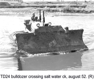
Photograph - Photograph - TD 24 Bulldozer crossing Salt Water Creek, 1962
Port of Portland Authority archivesFront: (no inscriptions) Back: P.H.T./ Print No. 15/2 Neg. No P18/ Date taken August 1962./ SUBJECT./ "TD 24" Bulldozer/ crossing Salt Water Creek (Ink stamp with blue pen and pencil additions, lower right) equ90 (pencil, center left) 15/2 (pen upper left)port of portland -
 Kinglake Historical Society
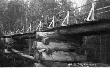
Log Bridge Kinglake
post card depicting horse and cart crossing log bridge at Kinglakeearly post card of Kinglake area including bridge and transportpost card of log bridge Kinglakekinglake, post card, log bridge, horse cart -
 Ringwood and District Historical Society
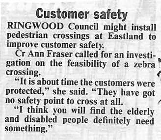
Newspaper, Scrapbook Clipping, Library Collection, Ringwood, Victoria, `
``Newspaper clipping from The Mail, 13-07-93 Customer safetyRingwood Council might install pedestrian crossings at Eastland to improve customer safety. Cr Ann Fraser called for an investigation on the feasibility of a zebra crossing.` -
 City of Moorabbin Historical Society (Operating the Box Cottage Museum)
Photograph, Black & White Postcard, Cheltenham Railway Station c1920, c1920
Although the Railway line had been planned for some time Sir Thomas Bent MP was responsible for making it happen in order to revitalize the fortunes of the Moorabbin Shire that he had represented for so long. The train line opened in 1881with 8 Stations between Caulfield and Mordialloc.The first Steam engine carried dignitaries and local residents. Bent also ensured that the Station houses in his constituency were built in a distinctive decorative cottage style. Bent faced severe criticism for diverting the rail line through his local area and for the expenditure on the Stations. Local residents established and cared for Gardens at the Stations and Cheltenham was awarded Best Garden c1910. The arrival of the Railway Line saw the traders move from Point Nepean Rd to Charman Rd and by 1910 various shops and business were present. 2016 - current has seen large protest rallies against the destruction of Mentone Station and Cheltenham Station as the Victorian State Government proceeds to remove Railway Level Crossings. A compromise to retain the Station buildings whilst placing the Rail Line underground is desired.Cheltenham Railway Station is one of the original cottage style stations ordered by Sir Thomas Bent when the rail line was extended from Caulfield to Mordialloc 1881Photograph Black & White Postcard showing the entrance to Cheltenham Railway Station c1920Valentine &Sons Pub Co Ltd Melb railways, cheltenham station, mentone station, south brighton station, railway level crossing removal 2016 -19, smith j l; smith mary ann, stanley helen, smith vic, smith harry redvers, chaff cutter, horse drawn carts, toll gates brighton, motor cars 1900, steam engines, early settlers, bentleigh, parish of moorabbin, city of moorabbin, county of bourke, moorabbin roads board, shire of moorabbin, henry dendy's special survey 1841, were j.b.; bent thomas, o'shannassy john, king richard, charman s, highett william, ormond francis, maynard dennis, market gardeners, vineyards, orchards -
 Bendigo Historical Society Inc.
Document - MALONE COLLECTION: GREETING CARDS
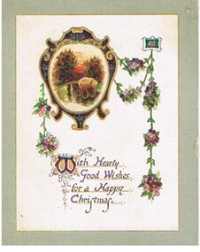
White card with 10mm grey border. Gold line between the grey & white. In the top left half is a maroon shape with gold edges and purple flowers on it. Inside the shape is a coloured scene of a man with a wagon load of hay crossing a stream. Two trees in the backgrou;nd at the sides of the road. A green stem with purple & mauve flowers hang from the left of the frame. On the right are two flower stems which meet at a small rectangle with a flower in it and a long stem with flowers hangs down to the bottom. Between the flowrs is printed inblack & purple with gold highlights & underline: With Hearty Good Wishes for a Happy Christmas. Gold printing inside.Raphael Tuck & Sonsperson, greeting cards, malone collection, malone collection, greeting cards -
Port Melbourne Historical & Preservation Society
Newspaper - Newspaper re South Melbourne and Port Melbourne, 1856
Copy of South Melbourne newspaper(?) cut off on right hand side. Items recorded include : Ferrars St: Sandridge Rd: York St: Crossing places at the lagoon: sub inspector of nuisances: slaughtering: candle manufactory: Sandridge Road toll: Mechanics Institute: Holy Trinityindustry - manufacturing, local government, kitchen, cr ross, cr service, cr gardiner, cr palk, mrs powell, joshua kenworthy, frederick goss, samuel dodds, south melbourne -
Port Melbourne Historical & Preservation Society
Photograph - Bridge Street, Then and Now series, David Thompson, 1996
Taken 1996 by David Thompson for "Then and Now""Bridge St - Then and Now" series. Bridge street, taken from near the tram crossing, looking towards Bay Street. Shows Station Hotel building, which had been converted into a private residence. (no 587 from series)built environment - commercial, built environment - domestic, engineering - roads streets lanes and footpaths, david thompson, bridge street, station hotel -
Port Melbourne Historical & Preservation Society
Plan - Proposed crossing, Rouse Street at Nott Street, George Kelly, Borough Surveyor, 27 Oct 1864
Place of Proposed Crossing in Rouse Street (Corner Nott Street) PlanGeo. Kelly, Cr.(?), Borough Surveyor, Sandridge, 27-10-1864engineering - roads streets lanes and footpaths, george kelly -
Port Melbourne Historical & Preservation Society
Photograph - Aerial view showing route of Lower Yarra Crossing Project (West Gate Bridge), Apr 1966
Black and white aerial photomap showing the proposed route of the Lower Yarra Crossing Project, later to become the West Gate Bridge and Freeway. April 1966'Lower Yarra Crossing Project' '296769'west gate bridge, transport - roads, engineering - bridges -
Port Melbourne Historical & Preservation Society
Document - Short Road Ferry ticket, c.1974
From the collection of Warren DOUBLEDAY. The short Road ferry ran between the end of Williamstown Road in Port Melbourne across the narrowest section of the Yarra River to the bottom of the Strand in Williamstown. The name came from it being the 'short road' between the two places. There was a type of ferry service in operation from around 1873 which was modernised in the 20th century to take cars and trucks across the river. It was operated by two heavy chains which sank to the river bed to allow ships to pass.A single trip 15 cent ticket for crossing the Yarra River from Williamstown on the Short Road Ferry. The off white ticket has two diagonal blue stripes and the number F 048261 printed on the side. transport - ferries, short road ferry, williamstown, transport - motor vehicles -
Port Melbourne Historical & Preservation Society
Document - Short Road Ferry ticket, c.1974
From the collection of Warren DOUBLEDAY. The Short Road ferry ran between the end of Williamstown Road in Port Melbourne across the narrowest section of the Yarra River to the bottom of the Strand in Williamstown. The name came from it being the 'short road' between the two places. There was a type of ferry service in operation from around 1873 which was modernised in the 20th century to take cars and trucks across the river. It was operated by two heavy chains which sank to the river bed to allow ships to pass.A single trip 15 cent ticket for crossing the Yarra River from Williamstown on the Short Road Ferry. The off white ticket has two diagonal blue stripes and the number P016322 printed on the side. transport - ferries, short road ferry, williamstown, transport - motor vehicles -
Port Melbourne Historical & Preservation Society
Document - Short Road Ferry ticket 1974, 7 Jan1974
From the collection of Warren DOUBLEDAY. The Short Road ferry ran between the end of Williamstown Road in Port Melbourne across the narrowest section of the Yarra River to the bottom of the Strand in Williamstown. The name came from it being the 'short road' between the two places. There was a type of ferry service in operation from around 1873 which was modernised in the 20th century to take cars and trucks across the river. It was operated by two heavy chains which sank to the river bed to allow ships to pass.A single trip 20 cent ticket for crossing the Yarra River from Williamstown on the Short Road Ferry. The off white ticket has two diagonal blue stripes and the number C049655 printed on the side. On reverse side of ticket -" 8.25 pm trip. 7-1-74 (last East bound for day'"transport - ferries, short road ferry, williamstown, transport - motor vehicles -
 Monbulk RSL Sub Branch
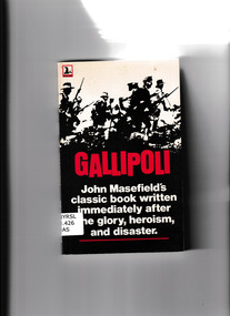
Book, John Masefield, Gallipoli, 1978
The Gallipoli campaign began one fateful Sunday morning in April 1915. It was to be Australia's test of nationhood. The Allied soldiers landed in the dark, crossing beaches tangled with barbed wire, passing mines and scaled the precipitous cliffs under machine-gun fire. An intense five-month campaign ensued, the lines so close that there was no respite from battle. With access to military documents, the poet John Masefield published this moving account of the Allied efforts in the Dardanelles less than a year after the defeat. The book was a huge success, as it gave glory to the bravery and determination of the young men who endured heat, toil, thirst, disease and pestilence but were always ready and willing to die in exultation for their cause.. Moving account of the Allied efforts in Dardanelles after the defeat.Ill, map, p.183non-fictionThe Gallipoli campaign began one fateful Sunday morning in April 1915. It was to be Australia's test of nationhood. The Allied soldiers landed in the dark, crossing beaches tangled with barbed wire, passing mines and scaled the precipitous cliffs under machine-gun fire. An intense five-month campaign ensued, the lines so close that there was no respite from battle. With access to military documents, the poet John Masefield published this moving account of the Allied efforts in the Dardanelles less than a year after the defeat. The book was a huge success, as it gave glory to the bravery and determination of the young men who endured heat, toil, thirst, disease and pestilence but were always ready and willing to die in exultation for their cause.. Moving account of the Allied efforts in Dardanelles after the defeat. world war 1914-1918 - campaigns - gallipoli, anzac corps -
 Monbulk RSL Sub Branch
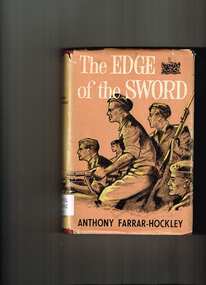
Book, Readers Book Club, The edge of the sword, 1954
In April 1951, at the height of the Korean War, Chinese troops advanced south of the 38th parallel towards a strategic crossing-point of the Imjin River on the invasion route to the South Korean capital of Seoul. The stand of the 1st Battalion, the Gloucestershire Regiment, against the overwhelming numbers of invading troops has since passed into British military history. In The Edge of the Sword General Sir Anthony Farrar-Hockley, then Adjutant of the Glosters, has painted a vivid and accurate picture of the battle as seen by the officers and soldiers caught up in the middle of it. The book does not, however, end there. Like the majority of those who survived, the author became a prisoner-of-war, and the book continues with a remarkable account of his experiences in and out of Chinese prison camps. This book is not an attempt at a personal hero-story, and it is certainly not a piece of political propaganda. It is, above all, an amazing story of human fortitude and high adventure.Ill, p.286non-fictionIn April 1951, at the height of the Korean War, Chinese troops advanced south of the 38th parallel towards a strategic crossing-point of the Imjin River on the invasion route to the South Korean capital of Seoul. The stand of the 1st Battalion, the Gloucestershire Regiment, against the overwhelming numbers of invading troops has since passed into British military history. In The Edge of the Sword General Sir Anthony Farrar-Hockley, then Adjutant of the Glosters, has painted a vivid and accurate picture of the battle as seen by the officers and soldiers caught up in the middle of it. The book does not, however, end there. Like the majority of those who survived, the author became a prisoner-of-war, and the book continues with a remarkable account of his experiences in and out of Chinese prison camps. This book is not an attempt at a personal hero-story, and it is certainly not a piece of political propaganda. It is, above all, an amazing story of human fortitude and high adventure. korean war 1950-1953 - history, korean war - campaigns - gloucestershire regiment -
 Bendigo Historical Society Inc.
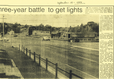
Newspaper - LONG GULLY HISTORY GROUP COLLECTION: INSTALLATION OF TRAFFIC LIGHTS EAGLEHAWK RD/CREETH ST
Copy of a newspaper article titled three-year battle to get lights printed on yellow paper. Date written at the top is September 19 - 1984.Photo shows Eaglehawk Rd with a man crossing the street and a car going past. A tractor is on the corner. The accompanying article mentions that residents have been campaigning to get the lights for over three years.bendigo, history, long gully history group, the long gully history group - installation of traffic lights eaglehawk rd/creeth st, long gully primary school, the road construction authority, ted coleman, bendigo city council, rite-way -
 Bendigo Historical Society Inc.
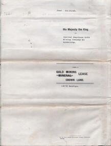
Document - MCCOLL, RANKIN AND STANISTREET COLLECTION: CENTRAL NAPOLEON GOLD MINING CO. N.L, 15th August 1950
... and crossing Empire and Sparrowhawk Roads and running a good distance... the minerunning between Harvey & Inglis Streets and crossing Empire ...Document: Gold Mining Lease Crown Land No 11272 Bendigo, entered in the register book Vol 331 Fol 36450, embossed seals of Central Napoleon Gold Mining Co N.L & King George VI, Map: No 11272 Mining District of Bendigo, Parish of Sandhurst, County of Bendigo, shows the minerunning between Harvey & Inglis Streets and crossing Empire and Sparrowhawk Roads and running a good distance beyond Sparrowhawk Rd.organization, business, industrial - mining, mccoll rankin & stanistreet, mining, gold mining, central napoleon -
 Monbulk RSL Sub Branch
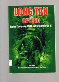
Book, Cobbs Crossing Publication, Long Tan and beyond : Alpha Company 6 RAR in Vietnam 1966-67, 2006
Here for the first time is included the story about the relief force - the men who turned defeat into victory. More than that, it is a story told by soldiers about soldiers. You will laugh and cry with them.Index, ill, maps, p.478.non-fictionHere for the first time is included the story about the relief force - the men who turned defeat into victory. More than that, it is a story told by soldiers about soldiers. You will laugh and cry with them.battle of long tan, vietnam conflict - australian involvement -
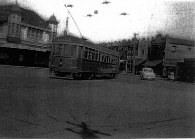 St Kilda Historical Society
Photograph, Railway Tram, c. 1950s?
... Railway Tram crossing Glenhuntly Road into Ormond Road... Carlisle Street St Kilda melbourne Railway Tram crossing Glenhuntly ...black and white photograph laminatedRailway Tram crossing Glenhuntly Road into Ormond Road -
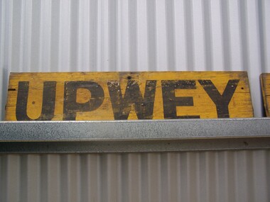 Puffing Billy Railway
Station Sign - Upwey
Upwey Station Sign; Upwey Railway Station is located on the Belgrave line in Victoria, Australia. This railway serves the Eastern region of Melbourne. Upwey Railway Station opened on the 3rd of June 1901. Upwey Railway Station has a crossing loop in the middle of a six kilometre section of single railway track between Ferntree Gully Railway Station and Belgrave Railway Station. The station was originally on the Upper Ferntree Gully to Gembrook narrow gauge line. The Upper Ferntree Gully to Gembrook Narrow Gauge railway line officially closed on the 30th of April 1954. It saw further use between 1955 and early 1958, when trains were operated by the Puffing Billy Preservation Society in co-operation with the Victorian Railways. The Upper Ferntree Gully to Belgrave section was converted to Broad Guage and re-opened on the 19th of February 1962. This station sign shown here was one of a number used on the Upwey Railway Station while it was Narrow Gauge. Historic - Victorian Railways Station sign used at Upwey StationUpwey wooden rectangle Station name sign pained yellow background with black font.Upweypuffing billy, station sign, upwey station, victorian railways