Showing 2376 items
matching 42
-
 Marysville & District Historical Society
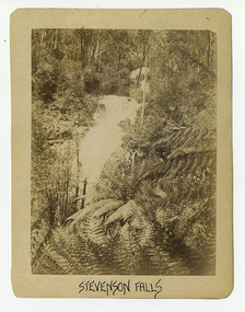
Photograph (Item) - Black and white photograph, Stevenson Falls, c1900
An early black and white photograph of Steavenson Falls in Marysville in Victoria.An early black and white photograph of Steavenson Falls in Marysville in Victoria. The Steavenson Falls is named after the Victorian Assistant Commissioner of Roads and Bridges, John Steavenson who arrived in Victoria in the early 1860s.ARMSTRONG COLLECTION 42 STATION STREET/ SANDRINGHAM 3191/ TEL. (03) 9521 5442/ IAN M.L. ARMSTRONG OAMstevenson falls, steavenson falls, marysville, victoria, john steavenson -
 Marysville & District Historical Society
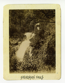
Photograph (Item) - Black and white photograph, Stevenson Falls, c1900
An early black and white photograph of Steavenson Falls in Marysville in Victoria.An early black and white photograph of Steavenson Falls in Marysville in Victoria. The Steavenson Falls is named after the Victorian Assistant Commissioner of Roads and Bridges, John Steavenson who arrived in Victoria in the early 1860s.ARMSTRONG COLLECTION 42 STATION STREET/ SANDRINGHAM 3191/ TEL. (03) 9521 5442/ IAN M.L. ARMSTRONG OAMstevenson falls, steavenson falls, marysville, victoria, john steavenson -
 Marysville & District Historical Society
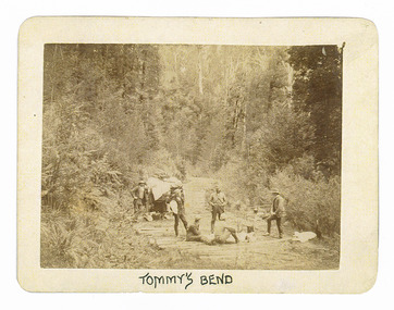
Photograph (Item) - Black and white photograph, Tommy's Bend, c1900
An early black and white photograph taken at Tommy's Bend near Marysville in Victoria.An early black and white photograph taken at Tommy's Bend near Marysville in Victoria. Tommy's Bend is a stretch of road 10 kilometres from Marysville on the Woods Point Road up to Lake Mountain. This road was originally constructed as a corduroy road (or log road) is a type of road or timber trackway made by placing logs, perpendicular to the direction of the road over a low or swampy area. The result is an improvement over impassable mud or dirt roads, yet rough in the best of conditions and a hazard to horses due to shifting loose logs.ARMSTRONG COLLECTION 42 STATION STREET/ SANDRINGHAM 3191/ TEL. (03) 9521 5442/ IAN M.L. ARMSTRONG OAMtommy's bend, marysville, victoria, marysville-wood's point road, corduroy road -
 Marysville & District Historical Society
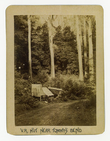
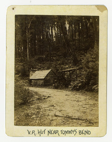
Photograph (Item) - Black and white photograph, V.R. Hut near Tommy's Bend, c1900
An early black and white photograph of a Victoria Roads worker's hut near Tommy's Bend near Marysville in Victoria. An early black and white photograph of a Victoria Roads worker's hut near Tommy's Bend near Marysville in Victoria. Tommy's Bend is a stretch of road 10 kilometres from Marysville on the Woods Point Road up to Lake Mountain.ARMSTRONG COLLECTION 42 STATION STREET/ SANDRINGHAM 3191/ TEL. (03) 9521 5442/ IAN M.L. ARMSTRONG OAMtommy's bend, marysville, victoria, marysville-wood's point road -
 Marysville & District Historical Society
Photograph (Item) - Black and white photograph, Beech Forest Beyond Tommy's Bend, c1900
An early black and white photograph of The Beeches, which is known as the Beech Grove, near Tommy's Bend near Marysville in Victoria.An early black and white photograph of The Beeches, which is known as the Beech Grove, near Tommy's Bend near Marysville in Victoria. Tommy's Bend is a stretch of road 10 kilometres from Marysville on the Wood's Point Road up to Lake Mountain. The Beeches Rainforest Walk is a loop that starts at Taggerty Cascades before winding through Myrtle Beech and Mountain Ash woodland and is one of the many walking tracks in and around Marysville. It is accessible from Lady Talbot Drive which is a 24 kilometer scenic rainforest car journey which passes a number of walks and waterfalls in the Yarra Ranges National Park. Lady Talbot Drive is named after Lady Sarah Elizabeth, the wife of Sir Reginald Talbot, who was the Governor of Victoria from 25th April, 1904 to 6th July 1908.ARMSTRONG COLLECTION 42 STATION STREET/ SANDRINGHAM 3191/ TEL. (03) 9521 5442/ IAN M.L. ARMSTRONG OAMtommy's bend, marysville, victoria, marysville-wood's point road, beech grove, wood's point road, lake mountain, beeches rainforest walk, taggerty cascades, myrtle beech, mountain ash, lady talbot drive, lady talbot forest drive, lady sarah elizabeth talbot, sir reginald talbot -
 Marysville & District Historical Society
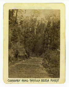
Photograph (Item) - Black and white photograph, Corduroy Road Through Beech Forest, c1900
An early black and white photograph of a corduroy road running through the forest near Marysville in Victoria.An early black and white photograph of a corduroy road running through the forest near Marysville in Victoria. A corduroy road (or log road) is a type of road or timber trackway made by placing logs, perpendicular to the direction of the road over a low or swampy area. The result is an improvement over impassable mud or dirt roads, yet rough in the best of conditions and a hazard to horses due to shifting loose logs.ARMSTRONG COLLECTION 42 STATION STREET/ SANDRINGHAM 3191/ TEL. (03) 9521 5442/ IAN M.L. ARMSTRONG OAMcorduroy road, marysville, victoria, beech forest -
 Marysville & District Historical Society
Photograph (Item) - Black and white photograph, Bridge Over The Cumberland, c1900
An early black and white photograph of a bridge over the Cumberland Creek near Marysville in Victoria.An early black and white photograph of a bridge over the Cumberland Creek near Marysville in Victoria. The Cumberland Creek is in the Cumberland Valley near Cambarville which was a timber town near Marysville. Cambarville is notable for its giant mountain ash (Eucalyptus regnans) trees within the Cumberland Memorial Scenic Reserve, and relics from former sawmills and gold mining. The Big Culvert is located nearby on the Marysville - Woods Point Road, which was historically part of the Yarra Track. Cambarville was established as a timber mill town in the 1940s. Timber mill owners A Cameron and FJ Barton named Cambarville. They established the mill to salvage timber from trees destroyed in the 1939 bushfires. Cambarville was impacted by the 2009 Black Saturday bushfires and any remaining structures were destroyed.ARMSTRONG COLLECTION 42 STATION STREET/ SANDRINGHAM 3191/ TEL. (03) 9521 5442/ IAN M.L. ARMSTRONG OAMcumberland creek, marysville, victoria, cumberland valley, cambarville, mountain ash, eucalyptus regnans, cumberland memorial reserve, the big culvert, marysville-wood's point road, yarra track, a cameron, fj barton, 2009 black saturday bushfires -
 Marysville & District Historical Society
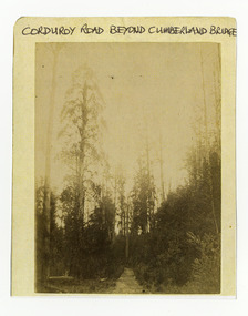
Photograph (Item) - Black and white photograph, Corduroy Road Beyond Cumberland Bridge, c1900
An early black and white photograph of a corduroy road running through the forest near Marysville in Victoria.An early black and white photograph of a corduroy road running through the forest near Marysville in Victoria. A corduroy road (or log road) is a type of road or timber trackway made by placing logs, perpendicular to the direction of the road over a low or swampy area. The result is an improvement over impassable mud or dirt roads, yet rough in the best of conditions and a hazard to horses due to shifting loose logs.ARMSTRONG COLLECTION 42 STATION STREET/ SANDRINGHAM 3191/ TEL. (03) 9521 5442/ IAN M.L. ARMSTRONG OAMcorduroy road, marysville, victoria -
 Marysville & District Historical Society
Photograph (Item) - Black and white photograph, Way to Cumberland Falls, c1900
An early black and white photograph of the forest near the Cumberland Falls in Victoria.An early black and white photograph of the forest near the Cumberland Falls in Victoria. The falls are located on the Marysville-Wood's Point Road. Cambarville is notable for its giant mountain ash (Eucalyptus regnans) trees within the Cumberland Memorial Scenic Reserve, and relics from former sawmills and gold mining. The Big Culvert is located nearby on the Marysville - Woods Point Road, which was historically part of the Yarra Track. Cambarville was established as a timber mill town in the 1940s. Timber mill owners A Cameron and FJ Barton named Cambarville. They established the mill to salvage timber from trees destroyed in the 1939 bushfires. Cambarville was impacted by the 2009 Black Saturday bushfires and any remaining structures were destroyed.ARMSTRONG COLLECTION 42 STATION STREET/ SANDRINGHAM 3191/ TEL. (03) 9521 5442/ IAN M.L. ARMSTRONG OAMcumberland falls, cambarville, marysville, victoria, waterfalls, postcard, souvenir, mountain ash, mining, timber mills, big culvert, yarra track, a cameron, fj barton, black saturday bushfires, 1939 bushfires, eucalyptus regnans -
 Marysville & District Historical Society
Photograph (Item) - Black and white photograph, Cumberland Falls, c1900
An early black and white photograph of Cumberland Falls near Marysville in Victoria.An early black and white photograph of Cumberland Falls near Marysville in Victoria. These falls are located on the Marysville-Wood's Point Road. Cambarville is notable for its giant mountain ash (Eucalyptus regnans) trees within the Cumberland Memorial Scenic Reserve, and relics from former sawmills and gold mining. The Big Culvert is located nearby on the Marysville - Woods Point Road, which was historically part of the Yarra Track. Cambarville was established as a timber mill town in the 1940s. Timber mill owners A Cameron and FJ Barton named Cambarville. They established the mill to salvage timber from trees destroyed in the 1939 bushfires. Cambarville was impacted by the 2009 Black Saturday bushfires and any remaining structures were destroyed.ARMSTRONG COLLECTION 42 STATION STREET/ SANDRINGHAM 3191/ TEL. (03) 9521 5442/ IAN M.L. ARMSTRONG OAMcumberland falls, cambarville, marysville, victoria, waterfalls, postcard, souvenir, mountain ash, mining, timber mills, big culvert, yarra track, a cameron, fj barton, black saturday bushfires, 1939 bushfires, eucalyptus regnans -
 Marysville & District Historical Society
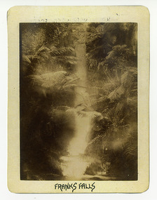
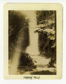
Photograph (Item) - Black and white photograph, Franks' Falls, c1900
An early black and white photograph of Franks' Falls.An early black and white photograph of Franks' Falls. Unable to ascertain location of these falls.ARMSTRONG COLLECTION 42 STATION STREET/ SANDRINGHAM 3191/ TEL. (03) 9521 5442/ IAN M.L. ARMSTRONG OAMfranks' falls -
 Marysville & District Historical Society
Photograph (Item) - Black and white photograph, Yarra Track Hotel, c1900
An early black and white photograph of a hotel along the Yarra Track.An early black and white photograph of a hotel along the Yarra Track. The Yarra Track is the former name of the gold fields road from Healesville to the Woods Point and Jordan Goldfields, in Victoria, Australia. A direct route via the Yarra River and the Great Divide was discovered by Rieck in September 1862 and became known as the Yarra Track. Early in 1863, the Victorian Government decided to construct a 193-kilometre (120 mile) road along the route. Its original width varied between 4 and 6 metres (12 and 20 feet), and was designed to accommodate horse-drawn vehicles. The Track involved the climbing of the Black Spur, descent into the Acheron Valley, and then through Marysville to the Cumberland where it followed the existing route. Unable to ascertain both the location and name of hotel.ARMSTRONG COLLECTION 42 STATION STREET/ SANDRINGHAM 3191/ TEL. (03) 9521 5442/ IAN M.L. ARMSTRONG OAMyarra track, healesville, wood's point, jordan goldfields, victoria, yarra river, great divide, reick, black spur, acheron valley, marysville, cumberland creek -
 Marysville & District Historical Society
Photograph (Item) - Black and white photograph, The "Scandinavians' - (Deserted), c1900
An early black and white photograph of The Scandinavian's Hotel and Boarding House along the Yarra Track.An early black and white photograph of The Scandinavian's Hotel and Boarding House along the Yarra Track. The Yarra Track is the former name of the gold fields road from Healesville to the Woods Point and Jordan Goldfields, in Victoria, Australia. A direct route via the Yarra River and the Great Divide was discovered by Rieck in September 1862 and became known as the Yarra Track. Early in 1863, the Victorian Government decided to construct a 193-kilometre (120 mile) road along the route. Its original width varied between 4 and 6 metres (12 and 20 feet), and was designed to accommodate horse-drawn vehicles. The Track involved the climbing of the Black Spur, descent into the Acheron Valley, and then through Marysville to the Cumberland where it followed the existing route.ARMSTRONG COLLECTION 42 STATION STREET/ SANDRINGHAM 3191/ TEL. (03) 9521 5442/ IAN M.L. ARMSTRONG OAMthe scandinavians', yarra track, healesville, wood's point, jordan goldfields, victoria, yarra river, great divide, reick, black spur, acheron valley, marysville, cumberland creek -
 Marysville & District Historical Society
Photograph (Item) - Black and white photograph, Camp Opposite The "Scandinavians', c1900
An early black and white photograph of a camp which was opposite The Scandinavian's Hotel and Boarding House along the Yarra Track.An early black and white photograph of a camp which was opposite The Scandinavian's Hotel and Boarding House along the Yarra Track. The Yarra Track is the former name of the gold fields road from Healesville to the Woods Point and Jordan Goldfields, in Victoria, Australia. A direct route via the Yarra River and the Great Divide was discovered by Rieck in September 1862 and became known as the Yarra Track. Early in 1863, the Victorian Government decided to construct a 193-kilometre (120 mile) road along the route. Its original width varied between 4 and 6 metres (12 and 20 feet), and was designed to accommodate horse-drawn vehicles. The Track involved the climbing of the Black Spur, descent into the Acheron Valley, and then through Marysville to the Cumberland where it followed the existing route.ARMSTRONG COLLECTION 42 STATION STREET/ SANDRINGHAM 3191/ TEL. (03) 9521 5442/ IAN M.L. ARMSTRONG OAMthe scandinavians', yarra track, healesville, wood's point, jordan goldfields, victoria, yarra river, great divide, reick, black spur, acheron valley, marysville, cumberland creek -
 Rutherglen Historical Society
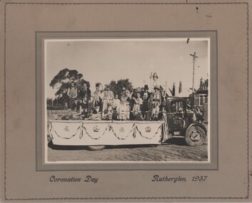
Photograph - Image, Coronation Day Rutherglen 1937, 1937
Children on the truck appear to be dressed in costumes representing individual nations of the Commonwealth.Black and white photograph, mounted on cardboard, of a group of children in costume on the back of a decorated truck.Printed at bottom of mount: "Coronation Day Rutherglen, 1937" Printed on truck door: "E. Hendy, Rutherglen, Phone 42"parade floats, commonwealth, coronation, children, e hendy -
 Kew RSL
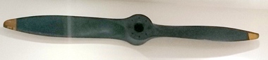
aircraft propeller, probably 1942
Avro Anson twin engine aeroplane was used by the RAAF in Australia prior & during WW2 as a trainerwooden propeller, metal leading edges, paintDRG No. LA 613c1 CHEETAH X; L.H.T.; d.7.33' p.6.96'; H.R. 1293 7; 2/42 -
 Ballarat Tramway Museum
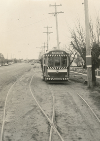
Photograph - Black & White Photograph/s - set of 3, Charles Craig, Aug. 1971
Yields information about tram operations in Albert St Sebastopol and the Grey St crossing loop.Set of three Black and white photograph of trams crossing at the Grey St Loop, Albert St Sebastopol .1 - 39 in the loop with destination of Sebastopol. .2 - 41 (Special) and 37 (Lydiard St Loop) at the loop - No. 41 has two Johnnie Walker roof advertisements. .3 - 42 and a single trucker in the loop with many people milling around. No. 42 running a special. Photo by Charles Craig, at the time of the first closure of the Ballarat system, 23/8/1971 when the Victoria St line closed.trams, tramways, albert st, grey st loop, sebastopol, tram 39, tram 41, tram 37, tram 42 -
 Warrnambool and District Historical Society Inc.
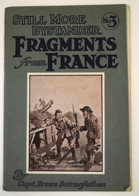
Book, Still More Bystander Fragments From France No. 3, c.1916
World War One Comic SketchesThis is a book of 42 pages with a green cover with a sepia-coloured photograph and printing on the front cover and an advertisement on the back cover. The pages contain sketches in sepia and blue tones. The pages have been bound with staples but the staples are missing.fictionWorld War One Comic Sketchesworld war one, captain bruce bairnsfather, fragments from france -
 Bendigo Historical Society Inc.
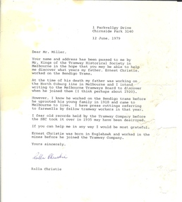
Document - BASIL MILLER COLLECTION: TRAMS - LETTER REQUESTING RESEARCH
Letter to Basil Miller from Ralla Christie requesting information about her Father Ernest Christie during the time he worked for the Bendigo Tramway, pre 1918. Reverse: written in blue ink 42 2637.person, individual, basil miller -
 Port Melbourne Historical & Preservation Society
Photograph - Swallow & Ariell Busy Bee Baby Garment Stall, 1914 - 1920
One of 44 black and white photos recording the work and contribution by Swallow & Ariell's "Busy Bee" for the First World War in Europe .42 - Swallow & Ariell's "Busy Bee" Baby Garment Stall created as a giant pram.built environment - industrial, business and traders, war - world war i, social activities, busy bee, swallow & ariell ltd, red cross -
 Port Melbourne Historical & Preservation Society
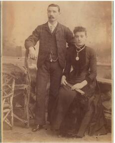
Photograph - John & Louisa Park, 1900
2 portrait black and white photos .01 John and Louisa (?) Park in studio pose .02 Louisa Park in studio pose Both were associated with Coggin Fruiterer and Green Grocer shop at 42 Ingles St.domestic life, families, john park, louisa park, louisa coggin -
 Bendigo Historical Society Inc.
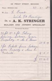
Document - L. PROUT COLLECTION: A. K. STRINGER INVOICE
Invoice dated 25/08/1959 from A. K. Stringer - Builder and Joinery Specialist - 42 Prout Street, Bendigo to Miss L. Prout, Quick Street, Bendigo for 25 pounds 16 shillings and 9 pence.business, retail, a. k. stringer -
 Bendigo Historical Society Inc.
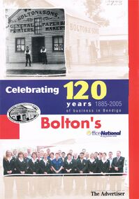
Document - BOOKLET: CELEBRATING 120 YEARS OF BUSINESS IN BENDIGO: BOLTON'S
Booklet - Celebrating 120 years of business (1885-2005) in Bendigo: Bolton's (Office National) 42 pp.with family/firm history along with advertising and product information. Benjamin Bolton, William Bolton, Arthur Bolton. Location:The Advertiserbendigo, business, bolton & sons, bolton & sons, bolton bros printers, william bolton, arthur bolton, benjamin bolton. bolton's -
 Bendigo Historical Society Inc.
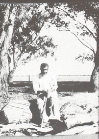
Photograph - HARRY BIGGS COLLECTION: UNKNOWN MALE
Photograph ( proof 42) of an unknown man in casual clothes. He is seated on a log and is holding what appears to be a walking stick He is of Aboriginal descent. Two trees and a fence line and cleared paddock can be seen in the backgroundperson, individual, aboriginal, koori, log, individual -
![View of the Township of Mt. Blackwood / [by] Nicholas Caire, circa 1876](/media/collectors/550653872162f11fb04854aa/items/57830cfbd0cdd1176c424e00/item-media/57830d7ad0cdd1176c428423/item-fit-380x285.jpg) Kew Historical Society Inc
Kew Historical Society IncPhotograph, Anglo-Australasian Photographic Company, View of the Township of Mt. Blackwood, c. 1876
Nicholas Caire was born on Guernsey in the Channel Islands in 1837. He arrived in Adelaide with his parents in about 1860. In 1867, following photographic journeys in Gippsland, he opened a studio in Adelaide. From 1870 to 1876 he lived and worked in Talbot in Central Victoria. In 1876 he purchased T. F. Chuck's studios in the Royal Arcade Melbourne. In 1885, following the introduction of dry plate photography, he began a series of landscape series, which were commercially successful. As a photographer, he travelled extensively through Victoria, photographing places few of his contemporaries had previously seen. He died in 1918. Reference: Jack Cato, 'Caire, Nicholas John (1837–1918)', Australian Dictionary of Biography.An original, rare photograph from the series 'Views of Victoria: General Series' by the photographer, Nicholas Caire (1837-1918). The series of 60 photographs that comprise the series was issued c. 1876 and reinforced a neo-Romantic view of the Australian landscape to which a growing nationalist movement would respond. Nicholas Caire was active as a photographer in Australia from 1858 until his death in 1918. His vision of the Australian bush and pioneer life had a counterpart in the works of Henry Lawson and other nationalist poets, authors and painters.‘View of the Township of Mt. Blackwood’ : Views of Victoria (General Series) No.42 : Albumen silver photograph | Photo on card with Title and Description on reverse | Mounted 24 x 30 cm; Photo 12 x 17 cm.On Reverse: ‘The locality which this illustration represents was formerly known as the Blackwood Forest, and has been the scene of considerable mining activity. The shallow alluvial diggings of the early days have given place to the deep sinking in search of reefs. This scene is characteristic of the wild appearance which many of the inland townships of Victoria represent.’nicholas caire (1837-1918), blackwood (vic), mount blackwood, landscape photography - victoria