Showing 2592 items matching "76"
-
 Bendigo Military Museum
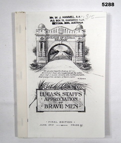
Book - BOOK - facsimile, Facsimile of book - final edition of original book created June 1919, "Lucas's Staffs Appreciation of Brave Men", June 1919
From Title Page - "The/Avenue of Honour/ Ballarat/ A Living Monument to all Loyal Citizens/ of Ballarat who volunteered for Active Service/ Abroad.".Soft cover book - facsimile. Cover - light cardboard, black print front and back. Illustrated - front -. Memorial Arch Illustration, back soldier. Cloth tape binding. 108 pages - paper, cut, plain, white. Facsimile. Illustrated - black print copy on white paper, photograph and illustrations. Front cover top - owner's stamp and handwritten mark.Front cover top - owner's stamp, black ink "MR W. J. HAMMILL, A.A.I.M./ P.O. Box 76, Kangaroo Flat/ VICTORIA, 3555, AUSTRALIA" Handwritten in gray lead pencil "$15-".books, history, ww1 -
 Bendigo Historical Society Inc.
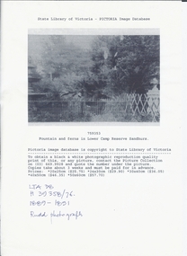
Photograph - LOWER CAMP RESERVE, SANDHURST, 1889 ?
Black and white photocopy of fountain and ferns in Lower Camp Reserve Sandhurst. It shows a garden with ferns, trees, fences an urn at right and a fountain at left. Copy of photograph held by state library. On front at top ' State Library of Victoria - pictoria image. Database '/759353/ ' Fountain and ferns in Lower Camp Reserve, Sandhurst. 'Handwritten ' LTA 38/H39358/76' Rudd Photograph.Ruddplace, landscape view, lower camp reserve sandhurst, photographs, sandhurst, garden, reserve, bendigo, photography, fountains, ferns -
 Bendigo Historical Society Inc.
Book - The Australian Scouts' First Book
The Australian Scouts' First Book was produced in the following editions:- (1) Jan 1931, (2) Sept. 1931, (3) Jan 1933, (4) June 1934, (5) Sept 1935, (6) Sept 1938, (7) Nov 1939 and (8) Jan 1941.Joan Filbey Collection: The Australian scouts' first book : complete tenderfoot and second class test instruction - Pages 5 to 76 are intact - Cover and a few pages are missing. The book is a rule and guide book for boy scouts, for example, how to tie knots, how to wear the correct uniform, tests for tenderfoots, signalling, first-aid, Morse code and tests to be undertaken.history, bendigo, scouts, the australian scouts' first book, joan filbey collection -
 Bendigo Historical Society Inc.
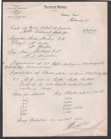
Document - BILL ASHMAN COLLECTION: CORRESPONDENCE
Notes written on paper with printed letterhead of Scott's Hotel, Collins Street, Melbourne, C.1., dated 31/3/44. Notes mention an experiment where a Scalebuoy was put in a lathe and the Electro Static Volts were measured at 46, 76, 131, 235 and 600 Revs per Minute. Tests were at the Radio School of Science, Melb. Technical College.sciences, instruments - general, scalebuoy, bill ashman collection - correspondence, scott's hotel melbourne, radio school of science, melb technical college, squadron leader mackay, burton, mackenzie -
 Bendigo Historical Society Inc.
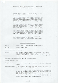
Document - LYDIA CHANCELLOR COLLECTION; 3BO LADIES TENNIS ASSOCIATION CORRESPONDENCE
A folder containing correspondence relating to the activites of the 3BO Ladies' Tennis Association dated from 5-5-39 to 12-11-1941. Much of the correspondence is addressed to 'Chance' ie Lydia Chancellor who had that radio name on 3BO and who used to give a radio report every week on 3BO. Formerly Folder 76. Removed to Box 801 on 8.11.2022Lydia Chancellororganization, club / society, 3bo ladies' tennis association, lydia chancellor collection, collection, 3bo ladies' tennis association, tennis, sport, women, clubs, societies, radio, wireless -
 Ballarat Tramway Museum
Document - Photocopy, Signalling Record Society of Victoria, "Safeworking on the Ballarat Electric Tramway System", Jul. 1988
Copy of an article by Peter Barry on the location of loops and operations of the Ballarat Tramway system. From pages 76 to 79 of the July 1988 issue of Somersault. Cover page, page 61 included. Covers running times, loop sections on Sebastopol, Lydiard St and Eastern Routes, Weekdays and Sats. and Suns., View Point, Signalling system, points where trams reversed in the section.trams, tramways, signals, crossing loop, secv, operations -
 Bacchus Marsh & District Historical Society
Map, Coimadai Parish Map, County of Bourke. Circa 1890s-1900s
The cadastral Parish of Coimadai, a subdivision of the County of Bourke, lies directly north of the township of Bacchus Marsh. The date of this map is uncertain. T.F. McGauran the person who made a photo-lithographic copy of the map was in charge of photo-lithography at the Victorian Department of Lands and Survey in the late 19th century until about 1910.A single page paper map showing the map for the Parish of Coimadai in the County of Bourke. A cadastral map showing parish boundaries and land ownership. A rectangle shaped area is missing from the centre of the map due to a tear or deliberate excision. The map is pasted into a bound volume containing 76 maps or plans in total. High resolution digital image stored on BMDHS computer network. Photo-lithographed at the Department of Lands and Survey, Melbourne by T.F. McGauran 26.8.[??] NOTE. Photo litho from L.P showing temporary surveys and occupation of land prepared for departmental use onlybacchus marsh region parish plans, coimadai parish maps, coimadai parish plan -
 Bendigo Historical Society Inc.
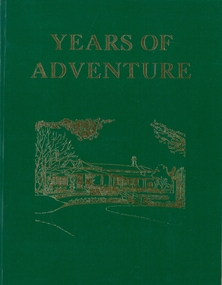
Book - YEARS OF ADVENTURE
Years Of Adventure, fifty years of service by the Country Women's Association of Victoria 1928-1978, printed by Hedges & Bell Pty Ltd Maryborough Victoria, green soft cover with gold lettering, 76 pages with black and white photographs. Presented to the Royal Victorian Historical Society Bendigo Branch by Audrey L Drechsler, Bendigo Northern Group President 9-7-1981.On front page in blue pen: Presented to the Royal Victorian Historical Society, Bendigo branch by (Mrs. Wm. J.) Audrey l. Dreschler, Bendigo Northern Group President 9/7/1981.clubs, social, country womens association -
 Bacchus Marsh & District Historical Society
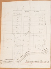
Map, Langmann's Estate Bacchus Marsh
The date of this map has not been determined. It bears the signature of D.A. Little upon of a portion of the map. Little was Bacchus Marsh Shire Secretary and Engineer between 1886 and 1914 which dates the map to some time between 1886 and 1914.A single page paper map showing a portions of land in part of Bacchus Marsh.The area shown is described as Langmann's Estate. The area is bounded by the Werribee River, Fisken Street, Waddle Street(sic.) (Waddell) and Lord Street. The map is pasted into a bound volume containing 76 maps or plans in total. High resolution digital image stored on BMDHS computer network. bacchus marsh victoria maps -
 Creswick Campus Historical Collection - University of Melbourne
Still Image, 1956
Subject: Ballarat-Creswick Plantations Block A . 9 brown envelopes marked Run 3 No. 84 - 92 of c.76 prints total. 1 brown envelopes marked Run 4 No. 127-136 of 9 prints total. 1956. Marked up with red pen. Stored in a brown cardboard file box marked Ballarat-Cres.Plantation Block A. Run 3.Aerial Photographs -
 Upper Yarra Museum
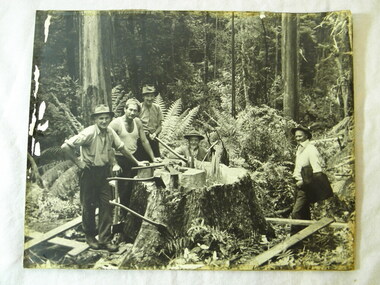
PH Timber Fellers, Fallers in Powelltown bush including George Potter
Mr George Potter Manager of the Victorian Hardwood Company mill at Powelltown is sitting in centre of photograph Image of three fallers with axes and two others around stump of large tree. Black and white photograph A3 mounted on cardboardrear of photo, writen description; central figure is Mr George Potter Manager VHC Powelltown Died c1949 presented by Mrs A G Potter daughter in-law of above 76 Bluff Rd Black Rock axe, ferns, powelltown, timber, fallers, george potter, victorian hardwood company -
 Bendigo Military Museum
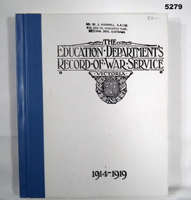
Book - BOOK, BIOGRAPHY - Facsimile, The Education Department, Victoria, "The Education Department's Record of War Service Victoria 1914-1919", c1921
Book - Facsimile - Hard cover, cloth tape binding. Cover - cardboard, front black print on white background. Blue cloth tape binding. 304 pages - paper, cut, plain, white. Illustrated - black and white copies of photographs and illustrations. Handwritten marking top front cover> Owners stamp top front cover.Front cover - top, handwritten, grey lead pencil "50-" Front cover - Owners stamp, black ink. "Mr. W.J. HAMMILL, A.A.I.M./PO Box 76, Kangaroo Flat/ Victoria, 3555, Australia"books, history, war service, ww1, biography -
Moorabbin Air Museum
Manual (Item) - Hawker Siddeley HS 748 Manual 4/6, HS748 (TRN) Aircraft Illustrated Parts Breakdown
Description: SUPERSEDES AAP 7211.004-4-1 to AAP 7211.004-4-6. 500 pages. Published by RAAF. Published 19/8/1980. AAP 7211.004-4B3. Section V (Ch.53 to Ch.57 and Chapters 61, 71, 73, 76, 77, 78, 80, 82, 83) of HS748 TRN Aircraft Illustrated Parts Breakdown. Level of Importance: World. -
 Bendigo Historical Society Inc.
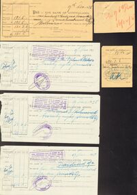
Document - COHN BROTHERS COLLECTION: PAYMENT SLIPS
Five pinned Bank payment slips dated 17th Dec 1925 with covering a. handwritten note 're 76 th Divi 16/12/25'. .b Francis Investment Co. c. Francis Investment Co. d. Mrs E M wilmott Watson. .e Mrs Harriet E Richmond. .f Dividend Account Cohn Bros Brewery £5,156/5/00.bendigo, industry, cohn bros brewery, e m wilmott watson. mrs harriet e richmond. cohns 69th dividend -
 Stanley Athenaeum & Public Room
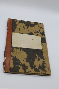
Cash Book, North Eastern District Fruit Growers Association
Local families, orchards, expenditure includes rent paid by Stanley Athenaeum CommitteeCardboard ledger covered in a black moire pattern with red leather spine. Type written red label attached to front cover stating purpose of information therein - titled 'North Eastern District Fruit Growers Association, Cash book. Inside title page handwritten description of contents including start date - from 17/9/42. Final entry 8/12/76.north eastern district fruit growers association, stanley, myrtleford -
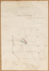
![Map, [Plan for road to give J. Allan access to permanent water at Coimadai] circa 1870s](/media/collectors/5e461d8021ea67224c82f2a1/items/67735190d671e67dd573a84c/item-media/6773533dd671e67dd573cd90/item-fit-380x285.jpg) Bacchus Marsh & District Historical Society
Bacchus Marsh & District Historical SocietyMap, [Plan for road to give J. Allan access to permanent water at Coimadai] circa 1870s
The date of this map or plan is uncertain but it appears to be from the early to mid 1870s. One of the landholders identified on the plan, James Allan of Coimadai died suddenly on the 9th July, 1874 (see Bacchus Marsh Express, 11 July, 1874, page. 3). There are mentions of an Allans Road at Coimadai in the Bacchus Marsh Express between 1887 and 1942.Single page map showing an excision of land belonging to Charles Ross which was selected to construct a road to give another landholder, J. Allan access to permanent water. Scale 1 chain to 1 inch. Part of a set of maps which are pasted into a bound volume containing 76 maps or plans in total. High resolution digital image stored on BMDHS computer network. Plan showing Excisions from Ross's selection and 1 chain road thro' the said selection in Coimadai to give J. Allan access to permanent water. Alistair ?? Shire Eng? 6?/5/7?coimadai victoria maps, coimadai roads and streets -
 Bacchus Marsh & District Historical Society
Map, Rough plan showing proposed deviation of road through McKenzie's Flat
The date of this map or plan is uncertain. McKenzie's Flat is a bushland picnic area on the Lerderderg River in the Lerderderg State Park close to Bacchus Marsh. Single page map showing a proposed deviation of the road near the McKenzie's Flat area close to Bacchus Marsh. The proposed deviation is shaded in pink, The existing road section to be replaced is shaded in blue. No scale is indicated. Part of a set of maps which are pasted into a bound volume containing 76 maps or plans in total. High resolution digital image stored on BMDHS computer network. mckenzies flat bacchus marsh, bacchus marsh roads and streets -
 Bendigo Historical Society Inc.
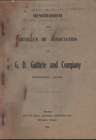
Document - CURNOW COLLECTION: BOOKLET MEMORANDUM AND ARTICLES OF ASSOCIATION OF G D GUTHRIE, 1912
BOOKLET - MEMORANDUM AND ARTICLES OF ASSOCIATION OF G D GUTHRIE AND COMPANY PROPRIETARY LIMITED. 37 pages (pp 3 - 8 memorandum & pp 9 - 37 articles) Printer: Bolton Bros. Handwritten in pencil (indistinct) on cover: Sec. 51 for increase of capital; Sec. 76 &77 for definition of resolutions; see also page 16, No. 41; Sec.4 for person registered; Sec. 108 re Director.person, individual, curnow collection -
 Bendigo Historical Society Inc.
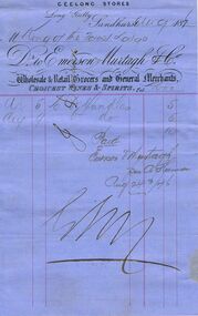
Document - ANCIENT ORDER OF FORESTERS NO 3770 COLLECTION: ACCOUNT/RECEIPT
Account/Receipt written on blue printed paper and dated August 1876. Printed on paper is: Geelong Stores Long Gully Sandhurst Dr to Emerson Murtagh & Co., Wholesale Retail Grocers and General Merchants. Choicest Wines & Spirits. Au 5 to b Candles 5/- and Au 9 b candles 5/- Total 10/-. Paid Emerson Murtagh per A Heemon? Aug 24th/76.societies, aof, correspondence, ancient order of foresters no 3770 collection - account/receipt, king of the forest, emerson murtagh & co., a heemon, j davidson -
 Canterbury Primary School
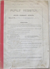
Pupils Register
Pupils register covering enrollment years 1976 - 1978. Register numbers 76/174 - 78/145. Columns include :- Reg.No., Name, DOB, Date of Enrollment, Name of Parent or Guardian, Residence of Parent or Guardian, Occupation of Parent or Guardian, School Last Attended, Date of Last Attendance at former School, Date of obtaining Qualifying Certificate, Date of obtaining Merit Certificate, Date of Last Attendance, Destination.PUPIL'S REGISTER/STATE PRIMARY SCHOOL/School No 3572, Canterburypupils, school, canterbury, register -
 Bacchus Marsh & District Historical Society
Map, Plan of land purchased by the Bacchus Marsh Shire Council from Mr. T. Low for a deviation of the Melbourne to Ballarat main road. 1877
The date of this plan is 1877 and the land indicted on it required for a road deviation is shaded in blue. It adjoins the Korkuperrimul Creek on one side which indicates the land is located just a few kilometers to the west of Bacchus Marsh. Single page map showing a portion of land purchased by the Bacchus Marsh Shire from Mr Thomas Low for the purpose of a road deviation. Land held by David Robertson is also shown on the map. Scale: 2 chains to 1 inch. Part of a set of maps which are pasted into a bound volume containing 76 maps or plans in total. High resolution digital image stored on BMDHS computer network. Surveyed by W. E. Standfield, Shire Engineer, Bacchus Marsh, 12/4/77bacchus marsh roads and streets, melbourne to ballarat road -
 Bacchus Marsh & District Historical Society
Map, Gaynor Street Area Land Sales, Maddingley, 1888
This map was produced for a major sale of land in the Maddingley area of Bacchus Marsh in 1888. The sale was conducted by two firms from Melbourne, Carney and Kelly 12 Swanston Street Melbourne. and 'Richardson, Kerr & Co. 40 Flinders Lane Melbourne. 136 blocks were for sale.A single page paper map showing land allotments for sale in the Maddingley area of Bacchus Marsh. Locations shown include Gaynor Street, Maddingley Road South, Parwan Road, Mitchem Street, Typpynge Street, Finn Street and East Maddingley Road. . The map is pasted into a bound volume containing 76 maps or plans in total. High resolution digital image stored on BMDHS computer network. bacchus marsh victoria maps, maddingley victoria maps, land use, maddingley victoria history, land sales bacchus marsh, land sales maddingley -
 Bacchus Marsh & District Historical Society
Map, Gaynor Street Land Sales, Maddingley, circa 1880s-1890s
This map was produced for a major sale of land in the Maddingley area of Bacchus Marsh. The precise date of the sale has not been determined. Features present on the map such as the Bacchus Marsh Railway Station indicate the land sale must have taken place some time after 1887 when the Railway Station opened. A single page paper map showing land allotments for sale in the Maddingley area of Bacchus Marsh. Locations shown include Gaynor Street, Maddingley Road South, Parwan Road, Mitchem Street, Typpynge Street, Finn Street and East Maddingley Road. . The map is pasted into a bound volume containing 76 maps or plans in total. High resolution digital image stored on BMDHS computer network. bacchus marsh victoria maps, maddingley victoria maps, land use, maddingley victoria history, land sales bacchus marsh, land sales maddingley -
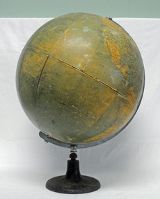 Orbost & District Historical Society
globe, C1958
This desk globe was owned by Evelyn Bessie Travaskis and used when teaching at State School Wairewa where she taught from 2-2-1945 until her retirement on 29-6-1956. She retired from the Education Department temporary staff, aged 76. ( More info.from Newsletter November 2015 by John Phillips). The Philips' Challenge Globe was commonly used in Australian schools in the teaching of geography. This item is associated with the history of education in East Gippsland. It is also associated with Evelyn Trevaskis.A large globe mounted on a round metal stand which has three holes for securing to a flat surface - a desk or tabletop. It sits in a half meridian.C 1958 Philips' Challenge Globetrevaskis-evelyn globe education-equipment-geography wairewa-school -
 Stawell Historical Society Inc
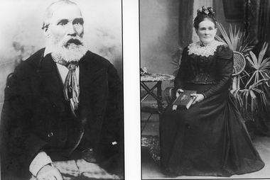
Photograph, Mr George & Eliza Hemley nee Chandler
Hemley George & Eliza nee Chandler. Eliza was born in 1838 in Bedfordshire England and died in 1914 aged 76. Liza Chandler married George Hemley on 4th Jan. 1854 in Shoreditch Middlesex. George was born in 1818 in Bedfordshire, England and died in 1887 aged 69 and buried in Stawell Cemetery. Photo taken by G. Woods Main St, Stawell. Additional detailed information also with photos and in Hemley file.One Black & White photo of separate images of George & Eliza Hemley. The print of George shows George seated close to the camera and the image of Eliza is of her seated on a cane chair in a dress with a lace collar and holding a book.stawell portrait -
 Eltham District Historical Society Inc
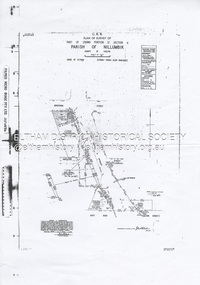
Document - Survey Plan, Country Roads Board et al, SP 12272A, Eltham-Yarra Glen Road; Brougham St to Dalton St, 1970-1976
1970 C.R.B. Plan of Survey of Part of Crown Portion 12 Section 4 Parish of Nillumbik, County of Evelyn Eltham-Yarra Glen Road, Shire of Eltham Shows Surveyor field notes, property ownership and building type and construction. John L. Roberts, Licensed Surveyor as noted 4 June 1970 Amendments in black by John L. Roberts, L.S. 20-12-76 See also EDHS_05783 (1958)eltham-yarra glen road, 1970, 1976, a.f. munday, brougham street, dalton street, eltham, eltham clinic, g.t. & e.a. donnelly, jarrold cottage, l.m. jarrold, m.s.m. skipper, main road eltham, map, maria street, matcham skipper, mobil service centre (eltham), mobil service station, napoleon street, survey plan, white cloud cottage, country roads board -
 Melbourne Tram Museum
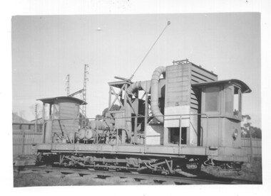
Photograph - Black and white - Track cleaner No. 6, 1940s
Photograph of MMTB Track cleaner - dust vacuum car No 6 at Preston Workshops. Reference page 76 of Destination City says the tram was built in 1915 by the Prahran and Malvern Tramways Trust as a general works car and rail flusher and further modified by the MMTB adding the vacuum equipment to try to control dust. Became known as No. 6 in 1934. Was out of use from the early 1940s and scrapped in 1948. Photo possibly early to mid 1940s.Yields information about track cleaner No. 6Black and white photograph on paper.trams, tramways, tram 6, track cleaner, preston workshops -
Beechworth Honey Archive
Map- Albury
Map centred on Albury, showing Wodonga, Beechworth, Yackandandah and Chiltern. Topographic survey scale 1:100,000. Map is colour, printed on paper. Produced by Department of Minerals and EnergySheet 8225 (ed.1) series R. 652 Notes written on side regarding brigade boundaries, constructed access roads and fire trails, dams suitable for quick fill pump and areas 'fuel reduction burns Autumn 76'.map, albury, wodonga, beechworth, yackandandah, chiltern, paper, topographic, beechworth honey -
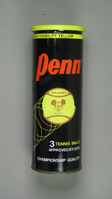 Tennis Australia
Ball container, Circa 1975
An unsealed Penn 'X-76 Extra Duty High Visibility' tennis ball can. Missing metal ring-pull seal lid and balls. Has Disney-branded plastic reclosure lid and a paper label on side of can stating:MADE ESPECIALLY FOR/WALT DISNEY PRODUCTIONS' above a graphical image of Mickey Mouse. Contains three Disney-branded tennis balls. Materials: Metal, Ink, Plastic, Rubber, Synthetic materialtennis -
 Bacchus Marsh & District Historical Society
Map, Subdivision of the Manor House Property Bacchus Marsh c.1908
This land sales plan shows allotments of land offered for sale in the inner township area of Bacchus Marsh in 1908. The land put up for sale was from the estate of the late Mr and Mrs J.E. Crook. That being James Elijah Crook and his wife Harriet, (nee Athorn). The Crooks had been resident in Bacchus Marsh since the 1840s and were prominent members of the community. They were prominent in the business, social and civic affairs of the town and district. In the 1850s the Crooks acquired the Manor House and nearby land once owned by the Bacchus family. James Crook died in 1889. When Harriet Crook died in February 1908 their estate was offered for sale. This included the large stone home known as the Manor House and various parcels of land including around 50 allotments of land near the Manor House, bounded by Young, Lerderderg, Crook and Main Streets. Most of these allotments of land were sold in October 1908. The Manor House itself was passed in at the sale and continued to be owned by the Crook family for several decades after 1908.A single page map on a single page of a bound volume of maps. The map shows portions of land for sale from the subdivision of the Manor House property in Bacchus Marsh in 1908. The names of most of the buyers of the portions of land have been hand-written into the various allotments they purchased. The maps are pasted into a bound volume containing 76 maps or plans in total. High resolution digital image stored on BMDHS computer network. bacchus marsh victoria maps, land sales bacchus marsh, manor house bacchus marsh, crook family bacchus marsh