Showing 608 items
matching boundary road
-
 Whitehorse Historical Society Inc.
Article, Reins to city, 1995
Whitehorse Council's Chief Executive Office, Dr Shirley Randall and Chief Commissioner, Geoff Oscar inspect the new boundary signs.Whitehorse Council's Chief Executive Office, Dr Shirley Randall and Chief Commissioner, Geoff Oscar inspect the new boundary signs.Whitehorse Council's Chief Executive Office, Dr Shirley Randall and Chief Commissioner, Geoff Oscar inspect the new boundary signs.city of whitehorse, logos, randell, shirley, oscar, geoff -
Whitehorse Historical Society Inc.
Article, Five wards for Whitehorse, 1996
Whitehorse City will be broken into five wards with two councillors in each ward, Whitehorse Council announced yesterday.Whitehorse City will be broken into five wards with two councillors in each ward, Whitehorse Council announced yesterday.Whitehorse City will be broken into five wards with two councillors in each ward, Whitehorse Council announced yesterday.city of whitehorse, electoral boundaries -
Whitehorse Historical Society Inc.
Document, Statement of accounts, 1933
Shire of Blackburn and Mitcham - Statement of accounts and balance sheet together with schedule of contracts for the year ended 30 Sep 1933.Shire of Blackburn and Mitcham - Statement of accounts and balance sheet together with schedule of contracts for the year ended 30 Sep 1933. Includes figures for the proposal to change boundaries of ridings within the shire.Shire of Blackburn and Mitcham - Statement of accounts and balance sheet together with schedule of contracts for the year ended 30 Sep 1933. local government, shire of blackburn and mitcham, financial documents -
Whitehorse Historical Society Inc.
Map, Nunawading, 1966
Nunawading's boundaries, schools, topography and railwaysNunawading's boundaries, schools, topography and railwaysNunawading's boundaries, schools, topography and railwaysmaps, city of nunawading, schools -
Whitehorse Historical Society Inc.
Article, Attack on 'emotional blackmail', 1994
Emotive claims that Box Hill faced a takeover by Nunawading if the City of Whitehorse did not go ahead have outraged Nunawading Mayor, Kevin Abbott.Emotive claims that Box Hill faced a takeover by Nunawading if the City of Whitehorse did not go ahead have outraged Nunawading Mayor, Kevin Abbott. Cr Abbott said Box Hill was publicly distancing itself from Nunawading yet privately it has considered extending its boundary to divide Nunawading at Blackburn Road.Emotive claims that Box Hill faced a takeover by Nunawading if the City of Whitehorse did not go ahead have outraged Nunawading Mayor, Kevin Abbott. local government, city of nunawading, city of box hill, abbott, kevin, amalgamations -
Whitehorse Historical Society Inc.
Map, Bruce, 1989
... Whitehorse Historical Society Inc. 2-10 Deep Creek Road ...Map of the Commonwealth Electoral Division of BruceMap of the Commonwealth Electoral Division of BruceMap of the Commonwealth Electoral Division of Bruceelectoral boundaries, bruce (commonwealth electoral division) -
Whitehorse Historical Society Inc.
Map, Chisholm, 1989
... Whitehorse Historical Society Inc. 2-10 Deep Creek Road ...Map of the Commonwealth Electoral Division of Chisholm. Scale 1:25,000.Map of the Commonwealth Electoral Division of Chisholm. Scale 1:25,000.Map of the Commonwealth Electoral Division of Chisholm. Scale 1:25,000.electoral boundaries, chisholm (commonwealth electoral division) -
Whitehorse Historical Society Inc.
Map, Deakin, 1989
... Whitehorse Historical Society Inc. 2-10 Deep Creek Road ...Map of the Commonwealth Electoral Division of Deakin. Scale 1:25000.Map of the Commonwealth Electoral Division of Deakin. Scale 1:25000.Map of the Commonwealth Electoral Division of Deakin. Scale 1:25000.electoral boundaries, deakin (commonwealth electoral division) -
Whitehorse Historical Society Inc.
Map, Deakin, 1977
... Whitehorse Historical Society Inc. 2-10 Deep Creek Road ...Map of the Commonwealth Electoral Division of Deakin. Scale 1: 25,000.Map of the Commonwealth Electoral Division of Deakin. Scale 1: 25,000.Map of the Commonwealth Electoral Division of Deakin. Scale 1: 25,000.electoral boundaries, deakin (commonwealth electoral division), australia. parliament -
Whitehorse Historical Society Inc.
Map, Proposed suburb names, 1999
Whitehorse City Council: proposed suburb names and boundaries. Version 3.1Whitehorse City Council: proposed suburb names and boundaries. Version 3.1Whitehorse City Council: proposed suburb names and boundaries. Version 3.1city of whitehorse, suburb names -
Whitehorse Historical Society Inc.
Map, Legislative Council - Electoral Provinces, 1991
... Whitehorse Historical Society Inc. 2-10 Deep Creek Road ...State of Victoria. Legislative Council Electoral Provinces. Sheet 3 Metropolitan Map. 1990 - 1991 redivision.State of Victoria. Legislative Council Electoral Provinces. Sheet 3 Metropolitan Map. 1990 - 1991 redivision.State of Victoria. Legislative Council Electoral Provinces. Sheet 3 Metropolitan Map. 1990 - 1991 redivision.electoral boundaries, victoria. parliament. legislative council -
Whitehorse Historical Society Inc.
Map, State Electoral Districts, 1978
... Whitehorse Historical Society Inc. 2-10 Deep Creek Road ...State Electoral Districts [Melbourne] 1975. Redivision (1977 subdivisions0. Scale 1: 90,000State Electoral Districts [Melbourne] 1975. Redivision (1977 subdivisions0. Scale 1: 90,000State Electoral Districts [Melbourne] 1975. Redivision (1977 subdivisions0. Scale 1: 90,000electoral boundaries, victoria. parliament. legislative assembly -
Whitehorse Historical Society Inc.
Map, State Electoral Provinces, 1978
State Electoral Provinces 1975 redivision (1977 subdivisions) Scale 1:90,0000State Electoral Provinces 1975 redivision (1977 subdivisions) Scale 1:90,0000State Electoral Provinces 1975 redivision (1977 subdivisions) Scale 1:90,0000victoria. parliament. legislative council, electoral boundaries -
Whitehorse Historical Society Inc.
Map, Legislative Assembly, 1984
State of Victoria Legislative Assembly electoral districts 1983 - 1984 redivision (Melbourne Metropolitan area) Scale 1:50,000State of Victoria Legislative Assembly electoral districts 1983 - 1984 redivision (Melbourne Metropolitan area) Scale 1:50,000State of Victoria Legislative Assembly electoral districts 1983 - 1984 redivision (Melbourne Metropolitan area) Scale 1:50,000victoria. parliament. legislative assembly, electoral boundaries -
Whitehorse Historical Society Inc.
Map, Aerial maps, 2/04/1966 12:00:00 AM
Melbourne 1966 project, runs 10A and 11A, lens 122 151.75 mm 9,800. Photo nos 77, 107, 109, 161, 163, 165.Melbourne 1966 project, runs 10A and 11A, lens 122 151.75 mm 9,800. Photo nos 77, 107, 109, 161, 163, 165. Areas and boundaries: Map no 77 W. Park and Cook Roads; E. Dubon Rd; N Oban Rd; S Reilly St. Map No 107. W. Indra Rd and Pakenham St; E. Rooks Rd & McLares Rd; N. Maroondah Hwy; S. Hawthorn Rd & Eley Rd. Map No 109 W. Elgar Rd. E. Blackburn Rd & McKean St; S. Eley Rd & Burwood Hwy. Map No 161. W. Elgar Rd & Huntingdale Rd; E. Blackburn Rd; N. Burwood Hwy; S. Waverley Rd. Map No 163. W. Blackburn Rd; S. Springvale Rd; N. Eley Rd & Hawthorn Rd; S. Glen Waverley Railway Line. Map No 165. W. Stanley Rd, Vermont South; E. Cathies Lane, Wantirna South; N. North of Burwood Hwy; S. High Street. Melbourne 1966 project, runs 10A and 11A, lens 122 151.75 mm 9,800. Photo nos 77, 107, 109, 161, 163, 165. aerial photographs, blackburn, blackburn south, forest hill, nunawading, box hill, burwood, burwood east, donvale, mount waverley, glen waverley, wantirna, vermont south, mitcham, ringwood north, ringwood -
 Whitehorse Historical Society Inc.
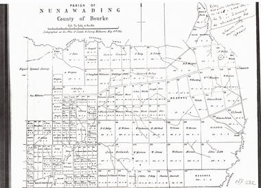
Document, Plan of Parish of Nunawading, 01/05/1864
Copy of plan of Parish of NunawadingCopy of plan of Parish of Nunawading, County of Bourke, lithographed at the Office of Lands and Survey, Melbourne, 13th May, 1864 showing boundaries of Koonung, Mullum Mullum and Dandenong Creeks.Copy of plan of Parish of Nunawadingland subdivision, parish of nunawading, county of bourke, elgars special survey, koonung creek, mullum mullum creek, dandenong creek -
Whitehorse Historical Society Inc.
Map, Aston, 1989
... Whitehorse Historical Society Inc. 2-10 Deep Creek Road ...Map of the Commonwealth Electoral Division of Aston. Scale 1:25,000Map of the Commonwealth Electoral Division of Aston. Scale 1:25,000Map of the Commonwealth Electoral Division of Aston. Scale 1:25,000electoral boundaries, aston (commonwealth electoral division) -
Whitehorse Historical Society Inc.
Map, State Electoral Districts, 1937
Map showing [Victorian] State Electoral Districts, Metropolitan, 1937.Map showing [Victorian] State Electoral Districts, Metropolitan, 1937. Scale: 40 chains to the inch.Map showing [Victorian] State Electoral Districts, Metropolitan, 1937.electoral boundaries, melbourne, elections -
 Whitehorse Historical Society Inc.
Article, Council votes 'no' to triennial elections, 1990
Council decisions not to switch to triennial elections was influenced by August '89 electionCouncil decisions not to switch to triennial elections was influenced by August '89 election in which all councillors forced reelection due to boundary changes. Council received $30,000 as local government grant.Council decisions not to switch to triennial elections was influenced by August '89 electioncity of nunawading, elections. -
Whitehorse Historical Society Inc.
Map, Dandenong Ranges area. Sheet 7, c1957
Detailed map covering area from Mitcham and Vermont to Ringwood and Heathmont.Detailed map covering area from Mitcham and Vermont to Ringwood and Heathmont. Shows streets, block boundaries, buildings, railway and creeks. Note says prepared from State Aerial Survey, April 1954 and Cadastrial Survey information July 1956.Detailed map covering area from Mitcham and Vermont to Ringwood and Heathmont. maps, mitcham, vermont, ringwood, heathmont -
Whitehorse Historical Society Inc.
Pamphlet, Your City 1971, 1971
Brief compendium of information about the city with names of councilors, ward boundaries etcBrief compendium of information about the city with names of councilors, ward boundaries etcBrief compendium of information about the city with names of councilors, ward boundaries etccity of nunawading, ward boundaries -
Whitehorse Historical Society Inc.
Article, School to fight brothel
Blackburn Primary School want City of Nunawading to 'stand up' against the Alfred Street brothel application.Blackburn Primary School want City of Nunawading to 'stand up' against the Alfred Street brothel application. The school strongly supports the principle of the private members bill moved in the Parliament by the Nunawading Province member, Mrs Rosemary Varty. It aims to give Councils the right to veto brothel applications within their boundaries.Blackburn Primary School want City of Nunawading to 'stand up' against the Alfred Street brothel application. brothels, blackburn primary school, no. 2923, city of nunawading, victoria. planning appeals board, varty, rosemary, alfred street, blackburn -
Whitehorse Historical Society Inc.
Map, State Electoral Map, 1926
State Electoral Map for 1926.State Electoral Map: Metropolitan and country areas, showing changes to electoral districts legislated in the Redistribution of Seats Bill 1926State Electoral Map for 1926.victoria, electoral boundaries -
Whitehorse Historical Society Inc.
Map, Melbourne Geological Map, 1937
Geological Map of Melbourne & Suburbs.Geological Map of Melbourne & Suburbs. Scale: 40 chains to 1 inch with inset 10 miles to 1 inch. Includes Municipal and Parish boundaries, railways and stations, electric tramways, cable tramways, Post Offices and State schools. Area bounded by Braybrook, Preston, Blackburn & Brighton. Printed on linen.Geological Map of Melbourne & Suburbs. melbourne, maps -
Whitehorse Historical Society Inc.
Document, Mitcham Letter Delivery, 1926
Delivery of Mitcham letters within prescribed boundaries.Delivery of Mitcham letters within prescribed boundaries.Delivery of Mitcham letters within prescribed boundaries.postal services, mitcham -
 Whitehorse Historical Society Inc.
Document, Landscape Submission, c 1976
A landscape submission written for the National Trust of Australia (Victoria) for Blackburn Lake and the Bell Bird Streets.A landscape submission written for the National Trust of Australia (Victoria) for Blackburn Lake and the Bell Bird Streets. Definitions given of boundaries of the Lake area, ownership, housing and gardens. Photographs and map.A landscape submission written for the National Trust of Australia (Victoria) for Blackburn Lake and the Bell Bird Streets.blackburn lake sanctuary, waratah crescent, blackburn, jeffery street, hill street, boongarry avenue, linum street, laurel grove, acacia avenue, city of nunawading, melbourne and metropolitan board of works, furness park, camberwell grammar school -
Whitehorse Historical Society Inc.
Document, Healesville Freeway Reservation Renewal Project, 2012
Agenda of meeting between VicRoads and Whitehorse Historical Society 1 Feb 2012.Agenda of meeting between VicRoads and Whitehorse Historical Society 1 Feb 2012, with supplementary documentation of boundaries, project purpose, and current land useAgenda of meeting between VicRoads and Whitehorse Historical Society 1 Feb 2012.forest hill, vermont, vermont south, healesville freeway reservation, vicroads -
Whitehorse Historical Society Inc.
Document, Municipal boundaries, 2010
... Whitehorse Historical Society Inc. 2-10 Deep Creek Road ...Talk given to Whitehorse Historical Society on changes to municipal boundaries in Victoria 1842-1995 on 13 February 2010.Talk given to Whitehorse Historical Society on changes to municipal boundaries in Victoria 1842-1995 on 13 February 2010.Talk given to Whitehorse Historical Society on changes to municipal boundaries in Victoria 1842-1995 on 13 February 2010.municipal boundaries, local government, cities and towns -
Whitehorse Historical Society Inc.
Map, City of Nunawading, c. 1960
Map showing boundaries of the City of Nunawading Scale: 1:36,000Map showing boundaries of the City of Nunawading Scale: 1:36,000Map showing boundaries of the City of Nunawading Scale: 1:36,000mitcham, nunawading, blackburn, blackburn north, blackburn south, burwood east, vermont south, forest hill, vermont -
Whitehorse Historical Society Inc.
Map, VR Box Hill - Blackburn, 1953
Maps of proposed station at Laburnum on Box Hill to Blackburn railway lines, by Victorian Railways, showing boundaries of Victorian Railways land and the proposed boundaries for Laburnum Station.Maps of proposed station at Laburnum on Box Hill to Blackburn railway lines, by Victorian Railways, showing boundaries of Victorian Railways land and the proposed boundaries for Laburnum Station.Maps of proposed station at Laburnum on Box Hill to Blackburn railway lines, by Victorian Railways, showing boundaries of Victorian Railways land and the proposed boundaries for Laburnum Station.laburnum railway station, laburnum street, blackburn, victorian railways