Showing 51254 items matching "c-p-l-c"
-
 Moorabbin Air Museum
Document (item) - CAC Collection - Technical Information - ATAR 09 C Turbojet Engine
Operating Time And Service Limits ATAR 09 C -
 Stawell Historical Society Inc
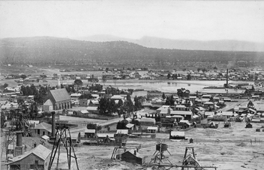
Photograph, Panorama of Stawell with St. Patrick’s Church on left & Poppet Heads in foreground. c 1878
Panorama of Stawell St. Patrick’s Church on left, T. Hogan & Co Tea Wine Spirits Merchants, St Georges Crushing mill on right of photo. Amalgamated Scotchmans mine on left.Panorama of Stawell with St. Patrick’s Church on left poppet Heads in foreground. St Georges Crushing mill on right of photo. Amalgamated Scotchmans mine on left.Victorian Views. C. Herbert, Photo. Stawell 1878stawell mining -
 Ringwood and District Historical Society
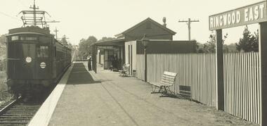
Photograph, Ringwood East Railway Station c.1926-30
Black and white photographs (2 copies, 1 large and 1 small)Ringwood East Railway Station c.1926-30 -
 Linton and District Historical Society Inc
Photograph, Associate Professor Edward Byam Brown, c.1950
Edward Byam Brown (1880-1966) was Associate Professor in Electrical Engineering at the University of Melbourne. He married Dr Vera Scantlebury in 1926.Black and white photograph showing a man wearing jacket, vest and tie, sitting surrounded by engineering equipment."Assoc. Prof. Edward Byam / Brown / c.1950".associate professor edward byam brown -
Glenelg Shire Council Cultural Collection
Photograph - Photograph - Department of Repatriation, c. 1920
Sourced from Casterton Town Hall (former Shire of Glenelg) D. JenningsBlack and white photo of large group of people, the Department of Repatriation, War Pension Section, taken outside building. Photo is glued to buff-coloured card.Front: 'Department of Repatriation WAR PENSION SECTION 1920' in white on bottom right of photograph 'C. J. Frazer PHOTO. MELBOURNE' - bottom right of mount -
 University of Melbourne, Burnley Campus Archives
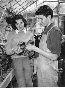
Photograph - Black and white and colour prints, Publicity Branch Victorian Department of Agriculture, Students Inside Glasshouse, c. 1960
Appears as an illustration in, "Green Grows Our Garden," A.P. Winzenried p 105.Black and white photograph. 2 copies. Thea Rimmer and Peter Trudgeon examining a potted Cyclamen. The other copy is a smaller colour photograph of the b/w one.On reverse of b/w copy, "Photograph by Publicity Branch Victorian Department Of Agriculture Ref. No. c.1695P." and, "c.1960."thea rimmer, peter trudgeon, cyclamen, green grows our garden, a.p. winzenried, glasshouse, students working outside -
 Ringwood and District Historical Society
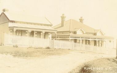
Photograph, Station Street Ringwood c.1910-1913 and later photograph of Dr Langley's then former residence in 1963
Two photographs taken approx. 50 years apart at Station Street looking towards Dr. Langley's residence on the right in the early photograph at the Kendall Street corner c.1910-1913. (Ref. p.176 Ringwood - Place of Many Eagles). The later photograph shows Dr Langley's then former residence in 1963.Typed below photograph, "Station St. cnr. Kendall St. Dr. Langleys residence on right, later became the site of Christian Scientists". -
RMIT GSBL Justice Smith Collection
Book, Rustomjee, Noshir C. J, The Rent Act : No. 7 of 1972 : being an exposition of the act, 1972
Includes fold out Dedication on second page: "To my very dear friend and colleague, Tim Smith, with my compliments Noshir C. J. Rustomjee 26th June 1986"rent control -- sri lanka, landlord and tenant -- sri lanka -
 Marysville & District Historical Society
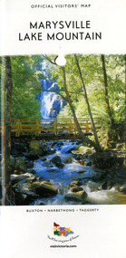
Map (Item) - Tourist map, Mystic Mountains Tourism, OFFICIAL VISITORS' MAP MARYSVILLE LAKE MOUNTAIN, Unknown
A visitors' map of Marysville and Lake Mountain produced by Mystic Mountains Tourism for Visit Victoria.A visitors' map of Marysville and Lake Mountain produced by Mystic Mountains Tourism for Visit Victoria.The Marysville and Lake Mountain Visitor Map and Touring Guide has been compiled and/ published by Mystic Mountains Tourism Inc. Copyright./ Production and artwork Graph Attack P/Lmarysville, lake mountain, victoria, australia, visitor's map, official visitors' map marysville lake mountain, buxton, narbethong, taggerty, visit victoria, mystic mountains tourism inc, graph attack p/l, mystic mountains, marysville triangle, marysville visitor information centre, marylands country house, black spur, steavenson falls, lady talbot drive, cambarville, cathedral ranges, wirreanda festival, lake mountain summit walk, summit walk loop, leadbeaters loop, day loop walk, buxton hotel, igloo roadhouse, karmann waters, silverstream b&b cottages, buxton trout and salmon farm, the niche wine bar, buxton post office & general store, choppers buxton roadhouse, woodlands rainforest bungalows, chestnut glade, black spur inn, wombat cottage, abbey lake luxury b&b spa cottages, mystic mountain ski hire & outdoors, pnl 4wdriving, blue views holiday units & ski hire, marapana agistment park & farm stay b&b, danico design, things of sand & stone, mantirri blueberry farm, allawah country cottages, amberview cottages, ashlar cottage b&b, black spur motel & caravan park, blackwood deluxe cottages, blackwood courtyard b&b, dalrymples guest cottages, delderfield, el kanah guest house, fruit salad farm, kerami guest house, keppels hotel, lake mountain-snow gum lodge, lomatia lodge, lyell guest cottages, magnolia house, keppel waters, lyrebird apartments, marysville caravan park, all view spa apartments, riverside cottages, maryton park b&b country cottages, melina cottage, mountain lodge, mystic mountains holiday cottages, nanda binya lodge, rendezvous luxury cottages, scenic b&b motel, the cumberland, south cathedral farm, tower motel, willowbank at taggerty, woodlands rainforest retreat, marysville & district country club inc, mystic mountains ski hire & outdoors, rubicon valley horse riding, marysville trout and salmon ponds, gallipoli park, keppels lookout, cambarville-yarra ranges national park, lake mountain-yarra ranges national park, lady talbot drive-yarra ranges national park, cathedral range state park, steavenson river, taggerty river, acheron river, lake mountain alpine resort, bruno's art and sculpture garden, manical mechanicals, uncle fred & aunty val's old style lolly shop, carmyle farm boutique, crossways historic country inn, fraga's, gilberts restaurant, heights licensed bistro, the old woolshed cafe, cathedral view natural therapies, crystal journey -
 Marysville & District Historical Society
Map (Item) - Tourist map, Mystic Mountains Tourism, OFFICIAL VISITORS' MAP MARYSVILLE LAKE MOUNTAIN, Unknown
A visitors' map of Marysville and Lake Mountain produced by Mystic Mountains Tourism for Visit Victoria.A visitors' map of Marysville and Lake Mountain produced by Mystic Mountains Tourism for Visit Victoria.The Marysville and Lake Mountain Visitor Map and Touring Guide has been compiled and/ published by Mystic Mountains Tourism Inc. Copyright./ Production and artwork Graph Attack P/Lmarysville, lake mountain, victoria, australia, visitor's map, official visitors' map marysville lake mountain, buxton, narbethong, taggerty, visit victoria, mystic mountains tourism inc, graph attack p/l, mystic mountains, marysville triangle, marysville visitor information centre, marylands country house, black spur, steavenson falls, lady talbot drive, cambarville, cathedral ranges, wirreanda festival, lake mountain summit walk, summit walk loop, leadbeaters loop, day loop walk, buxton hotel, igloo roadhouse, karmann waters, silverstream b&b cottages, buxton trout and salmon farm, the niche wine bar, buxton post office & general store, choppers buxton roadhouse, woodlands rainforest bungalows, chestnut glade, black spur inn, wombat cottage, abbey lake luxury b&b spa cottages, mystic mountain ski hire & outdoors, pnl 4wdriving, blue views holiday units & ski hire, marapana agistment park & farm stay b&b, danico design, things of sand & stone, mantirri blueberry farm, allawah country cottages, amberview cottages, ashlar cottage b&b, black spur motel & caravan park, blackwood deluxe cottages, blackwood courtyard b&b, dalrymples guest cottages, delderfield, el kanah guest house, fruit salad farm, kerami guest house, keppels hotel, lake mountain-snow gum lodge, lomatia lodge, lyell guest cottages, magnolia house, keppel waters, lyrebird apartments, marysville caravan park, all view spa apartments, riverside cottages, maryton park b&b country cottages, melina cottage, mountain lodge, mystic mountains holiday cottages, nanda binya lodge, rendezvous luxury cottages, scenic b&b motel, the cumberland, south cathedral farm, tower motel, willowbank at taggerty, woodlands rainforest retreat, marysville & district country club inc, mystic mountains ski hire & outdoors, rubicon valley horse riding, marysville trout and salmon ponds, gallipoli park, keppels lookout, cambarville-yarra ranges national park, lake mountain-yarra ranges national park, lady talbot drive-yarra ranges national park, cathedral range state park, steavenson river, taggerty river, acheron river, lake mountain alpine resort, bruno's art and sculpture garden, manical mechanicals, uncle fred & aunty val's old style lolly shop, carmyle farm boutique, crossways historic country inn, fraga's, gilberts restaurant, heights licensed bistro, the old woolshed cafe, cathedral view natural therapies, crystal journey -
 Charlton Golden Grains Museum Inc
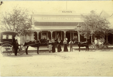
Photograph, Clarke Bros Photographers, Klug's East Charlton Hotel c. 1892, c.1892
East Charlton Hotel High St Charlton c. 1892. Proprietor C. Klug. Established by John Flug who built Charlton's first commercial building in 1875 - a slab and bark inn 100 metres to the rear of this building. Photo taken by Clark Bros, Windsor, MelbourneBlack & white photo, mounted, postcard size. Signage Klug's on top of the building, East Charlton Hotel below that. Four men standing on footpath, four women and a man holding a dog standing on the road. On the left is a horse and covered buggy with a man standing in front of the buggy. There is a boy sitting in the buggy holding the reins. On the right is an open gig with a man and two women in it.c. klug, john flug, clark bros, east charlton hotel, business, industry -
 Bialik College
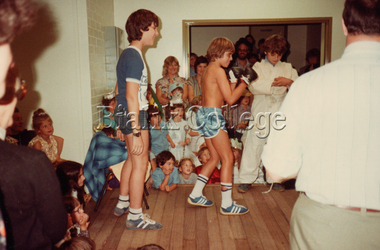
Photograph, Purim activity, c. 1980s, c. 1980s
Students, including Wayne Krongold (centre), enjoying a Purim activity, c. 1980s.purim, 1980s -
 Charlton Golden Grains Museum Inc
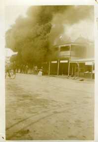
Photograph, Petrol bowser fire c.1930, c.1930
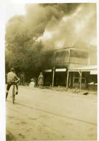
Petrol bowser fire c. 1930 cnr High & Armstrong St CharltonSmall black & white snapshot of petrol bowser fire. Thick black smoke behind tree. Boy on a bicycle, small crowd of onlookers, two men carrying a table. fire, charlton -
 Charlton Golden Grains Museum Inc
Photograph, Petrol bowser fire c.1930, c. 1930
Petrol bowser fire c. 1930 at garage cnr High & Armstrong StsSmall black & white snapshot of a petrol bowser fire. Boy on a bicycle and a man watching from the road. Bicycle propped in gutter.fire, charlton, business, industry -
 Stawell Historical Society Inc
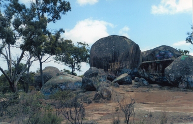
Photograph, Sister Rocks 2011-- Coloured photograph looking South
Colour Photograph Taken c 2011 Sister Rocks Stawell This photo is of a well known land mark along the Western Highway. They take their name from 3 sisters named Levy, who camped there with their parents during the early days of Stawell.Colour Photograph of Sister Rocks looking South c 2011South Taken c 2011stawell tourism -
 Emerald Museum & Nobelius Heritage Park
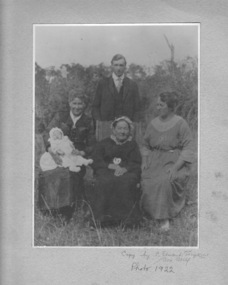
Photograph, Nightingale/Thompson Collection, 1922
Elderly woman possibly Emma Nightingale's mother Albertina Auguste Sophia Thompson (nee Metzenthin d. 1932) or Emma Nightingale (1859 - 1949) Black and white photograph in cream folder of 3 women (one holding a baby) and standing young man in the backgroundinscription on cream card: copy by C Stuart Tompkins Box Hill 1922thompson collection, nightingale -
![Cr. H.F. Mogg, Mayor [of Kew] 1939-40](/media/collectors/550653872162f11fb04854aa/items/5922bdded0cde3131ca24883/item-media/5c1ec47321eabe0988e12091/item-fit-380x285.jpg) Kew Historical Society Inc
Kew Historical Society IncPhotograph, C Stuart Tompkins ARPS, Cr. H.F. Mogg, Mayor [of Kew] 1939-40, 1939
Kew achieved independence from the Boroondara Roads Board in 1860. As a new municipality, its first three leaders were designated as chairmen. On becoming a borough in 1863, its leaders were identified as mayors. The earliest photographs date from ca.1906, when the Town of Kew commissioned the noted local photographer Josiah E Barnes to produce standardised portraits of former mayors to be displayed in the Mayoral Chamber of the Town Hall. The collection also includes photographs by other well-known photographic studios such as Burlington Studios, Melba – Melbourne, Stuart Tompkins, Spencer Shier and Talma & Co. The majority of mounts identify the photographer. Eighty photographs are housed in their original frames.This portrait is one of a series of mounted and framed photographic portraits of mayors and town clerks of the former Borough, Town and City of Kew. The portraits were transferred by the City of Kew to the Kew Historical Society in March 1989. A Significance Assessment in 2018, funded by the National Library of Australia confirmed the historic, and often artistic significance of the series.Unframed portrait of Cr. Cr. H.F. Mogg, Mayor of Kew 1939-40. The photograph follows a typical layout or style in that it is laid down on an inscribed board. The inscription identifies the name of the mayor and the year/s that he/she served.Cr. H.F. Mogg / Mayor 1939-40 C Stuart Tompkins ARPSmayors of kew (vic), australian photographers - c. stuart tompkins a.r.p.s. - camberwell (vic), cr. h.f. mogg, kew (vic.) — municipal collection -
 Montmorency–Eltham RSL Sub Branch
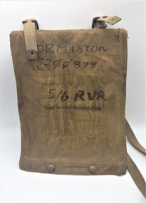
Equipment - Map Case No. 2, 1942
This 1942-dated Map Case was still in use post-1982 when it was used by a member of the 5/6 Royal Victoria Regiment. This new Melbourne-based battalion was created on the 17 August 1982. Open-sided with a khaki canvas flap attached to a resin-impregnated board.. Hinged to the top edge is a celluloid cover. Four clips holds the cover (and any map) to the backing board. The flap is secured by a pair of Carr Australia press studs on the back. The underside of the flap has four loops for chinagraph pencils and a wider pocket and loop for a Protractor. Two brass buckles are provided for a web shoulder sling. C. G. Hartley & Co. 1942 ORMISTON 3200879 5/6 RVR -
 City of Moorabbin Historical Society (Operating the Box Cottage Museum)
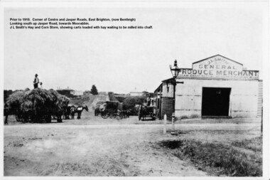
Photograph - Photograph Hay & Corn Store, Before 1910, Smith's Hay & Corn Store, Cnr. Centre and Jasper Roads, Bentleigh, Late 19th to early 20th Century
The first photograph was taken prior to 1910. The location is at the corner of Centre and Jasper Roads, East Brighton, (now known as Bentleigh). It is an early view of John L. and "Minnie" Smith's Hay and Corn Store, situated on the South West corner of those two roads. The first photo was taken prior to the introduction of electricity in the area. A gas lamp and horse "hitching post" can be seen "in shot". There are several loaded wagons waiting in line to have their hay milled to chaff. Farmers came from places as distant as Carrum to have their loads of hay milled into chaff. John Smith was born in 1860 in Point Nepean Road, Brighton, and Minnie was born in Patterson Road, Moorabbin, in a wattle and daub cottage with earthen floor and butter muslin over the windows. The couple married in 1884, Minnie was a devout Methodist and the family became very involved in the development of the local Methodist church. The couple had four children and during the 1890s Depression their first child died, they lost all their possessions, and John's family struggled to survive. Finally in the late 1890s JL Smith was able to rent a shed from Mr Henry Box on the corner of Centre and Jasper Roads, and he later purchased that property. With the gradual improvement in the economy, and the development of the successful market gardening industry in the Shire of Moorabbin, JL Smith's produce store became quite prosperous. Over some years the little "shed" developed into a thriving Hay and Corn Store. JL Smith went on to become Moorabbin Shire President in 1914. He and his wife were active in assisting soldiers returning injured from the 1st WW, in the local Methodist Church and other early community projects. Smith was a typical example of the majority of the early settlers in the Shire of Moorabbin, being god-fearing and devoted to the idea of service to the community. The photographs demonstrate the primitive conditions and early development of what is now a bustling and well-recognised area of Bentleigh, (known as east Brighton before 1907). The photo shows a gas lamp in use before the introduction of electricity in 1916. The Smith's story is representative of the many early pioneering traders, who elected to "set up shop", who suffered the adversity of the 1890s depression, but who survived and made their living in the largely undeveloped area of East Brighton ( now Bentleigh) district. Two black and white early photographs both of the same location. The photos are of the corner of Centre and Jasper Roads, Bentleigh. (Prior to 1907 this area was known as East Brighton.) Both photos show J.L Smith's General Merchant Produce store. "Steam Chaff Cutting and Corn Crushing Mills" and the surrounding area at differing stages. In the first photo taken prior to 1910, we can see there are several horse-drawn carts loaded with hay waiting to be milled, a gas lamp and a horse "hitching post". The store is just a single unadorned, shed. The later, second photo of the same area, shows improvements and the further development of that site. On the back of the photo "Hay and Corn Store -/ not later than 1910."/"Photographer /Victor C Smith,/ Phone Number XL1472"/hitching post, methodist church, smith minnie, moorabbin shire president, gas lamp, east brighton district, 1890s depression, wattle and daub cottage, centre road, jasper road, box henry, smith john l -
 The 5th/6th Battalion Royal Victoria Regiment Historical Collection
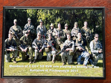
Photograph - Photo of C Coy soldiers, C Coy soldiers role paying as enemy party
Photo contains 15 soldiers holding weapons posing who are members of C Coy RVR role playing as enemy for the Battalion at Puckapunyal 2011rainf, infantry, enemy party, c coy, 5/6 -
 The 5th/6th Battalion Royal Victoria Regiment Historical Collection
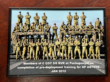
Photograph - Photo, Photo of C Coy 5/6 RVR on completion of pre-deployment training
Photographic of members of C Coy 5/6 RVR at Puckapunyal on completion of pre-deployment training for OP Astute January 2012 in a wooden frame -
 Stawell Historical Society Inc
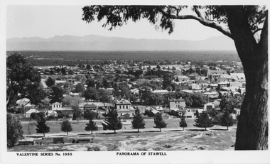
Photograph, Panorama of Stawell from Big Hill c 1920's with the Court House and Town Hall
Valentine Series No. 1085. Panorama of Stawell. c1930 Tree on Right of photo taken from Big Hill. Businesses in Patrick Street Visible. Town Hall does not have Clock Tower. One postcard & one enlargement. Black & White Panorama of Stawell from Big Hill with 9 evenly spaced trees in foreground & large tree to the right, c 1920's.Valentine Series No. 1085 Panorama of Stawell.stawell, panorama, streetscape -
 Mrs Aeneas Gunn Memorial Library
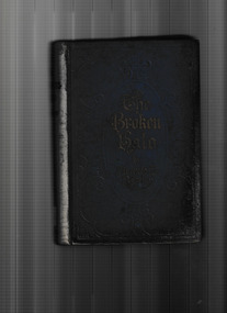
Book, Florence L. Barclay, The broken halo, 1913
A romantic novelp.408.fictionA romantic novel england - fiction, romantic fiction -
 Bialik College
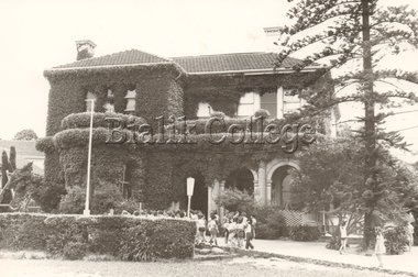
Photograph, Shakespeare Grove, c. 1960s, c. 1960s
Shakespeare Grove, c. 1960s. Please contact [email protected] to request access to this record.shakespeare grove, 1960s, building, campus -
 Bialik College
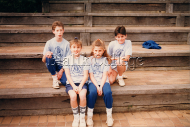
Photograph, Sports team, c. 1990s, c. 1990s
Sports team, c. 1990s. Please contact [email protected] to request access to this record. -
 Bialik College
Photograph, Netball team, c. 1990s, c. 1990s
Netball team, c. 1990s. Please contact [email protected] to request access to this record.sport -
 Wonga Park Community Cottage History Group
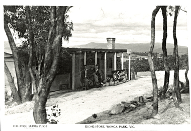
Photograph (Item) - Black and White, Wonga Park Kiosk Store c 1948, c. 1931
Wonga Park Kiosk Store c 1948, erected and run by Arthur and Teddy DavisPhoto is named 14880024.jpg on CD -
 Charlton Golden Grains Museum Inc
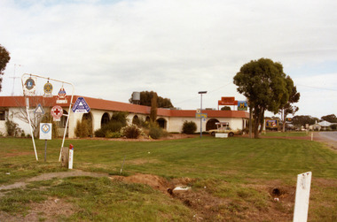
Photograph, Charlton Shire, Charlton Motel c. 1987, c.1987
The motel was built in the 1960s. Photo is part of a Charlton Shire streetscape series c.1987.Colour photograph of the Charlton Motel taken looking south east. The Motel is a white brick, single-storey building with a red trimmed roof. The verandah and some front windows are arches. There is a large garden bed with shrubs in front of the verandah. On the left are signs for various community organisations - Lions, Rotary, Apex, Young Farmers, Red Cross, and Amity. A cream coloured car is parked in the drive way business, charlton, motel -
 Charlton Golden Grains Museum Inc
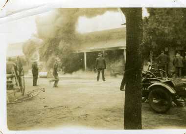
Photograph, Petrol bowser fire c.1930, c.1930
Spectators at petrol bowser fire, cnr of High & Armstrong Sts Charlton c. 1930Small black & white snapshot of petrol bowser fire. three men on the road, several men under tree, There is also a wagon, bicycle and motorbike with sidecar.fire, charlton, armstrong street -
 Charlton Golden Grains Museum Inc
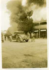
Photograph, Petrol bowser fire c.1930, c.1930
Petrol bowser fire c. 1930 at garage cnr High & Armstrong St CharltonSmall balck & white snapshot of petrol bowser fire. a crowd of onlookers including a boy on a bicycle and a car on the road.fire, charlton, armstrong street