Showing 1689 items
matching canterbury road
-
 Canterbury History Group
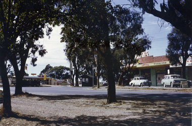
Photograph - Legg's Old Fruit Shop, c1960
... Canterbury Road...Old timber shop at 259 Canterbury Road occupied by grocers...Canterbury History Group 142 Canterbury Road Canterbury ...Old timber shop at 259 Canterbury Road occupied by grocers from c1893 - 1913. Bought by James Phelp in 1913 became a green grocer. Later by Fred Legg and his sons until c1960. Became an electrical goods and radio repair shop until gutted by fire in the late 1960's.canterbury, canterbury road, legg> fred, phelp> james, petrol pumps, shops -
Canterbury History Group
Document - School project: A Pioneer's Story, Thomas, Aubrey and Bean, Victor, 1922
... Canterbury Road... by J.B.Maling, Maling Road and Canterbury Road. photocopied...Canterbury History Group 142 Canterbury Road Canterbury ...An interview with John Butler Maling on his experiences as a pioneer in Canterbury conducted by Victor Bean and Aubrey Thomas , pupils at Cantrbury Primary School for a school project in 1922. Hand written and illustrated with photographs of Canterbury Primary School, Canterbury Library, Canterbury Gardens , Maling house in Balwyn Road on site of the original house built by J.B.Maling, Maling Road and Canterbury Road. photocopiedcanterbury, maling> john butler, canterbury primary school, canterbury gardens, canterbury library, maling road, canterbury road, bean> victor, thomas> aubrey, pioneers -
Whitehorse Historical Society Inc.
Map, City of Nunawading, 1973
... covered from Canterbury Road to Burwood Road and Terrara Road... School. Area covered from Canterbury Road to Burwood Road... Canterbury Road to Burwood Road and Terrara Road to Morack Road ...Map showing streets, plot numbers, schools, open space and land usage.Map showing streets, plot numbers, schools, open space and land usage. A project by A Gray, student at Vermont High School. Area covered from Canterbury Road to Burwood Road and Terrara Road to Morack Road. Scale: 800 ft: 1 inchMap showing streets, plot numbers, schools, open space and land usage.vermont south, vermont, vermont high school, parks and reserves -
Canterbury History Group
Booklet, Kelly, Robin, True tales of an antique dealer, July 2019
... 245 Canterbury Road, Canterbury, Victoria, Australia... in Canterbury Road, Canterbury. A5 32 page booklet; colour photographs ...History and story of Robin Hood and her antique dealership in Canterbury Road, Canterbury.A5 32 page booklet; colour photographsnon-fictionHistory and story of Robin Hood and her antique dealership in Canterbury Road, Canterbury. antique shops, canterbury antiques, canterbury shopping centre -
 Whitehorse Historical Society Inc.
Document, Certificate of Title, 19/07/1918
... canterbury road mitcham... for 43 acres Fronting on Canterbury Road near Mitcham Road, being... on Canterbury Road near Mitcham Road, being part of Crown Portion 124 ...Photocopy of Certificate of Title Vol. 4156 Folio 831198 for 43 acres Fronting on Canterbury Road near Mitcham Road, being part of Crown Portion 124, Parish of Nunawading, County of Bourke in the name of James Harley Malcolm, 19/7/1918. Last subdivision dated 22/5/1926- current site of Glenburnie Roadland subdivision, malcolm, james harley, mitcham road mitcham, glenburnie road mitcham, canterbury road mitcham, various surnames -
 Surrey Hills Historical Society Collection
Photograph, Centenary Movie Snap, Frederick John (Fred) Ambler
... 362 canterbury road... Sunbury Crescent; 1914-1950): 362 Canterbury Road (residence... Sunbury Crescent; 1914-1950): 362 Canterbury Road (residence ...Frederick John Ambler was an upholsterer. Married Beatrice Annie Martin in 1897. Fred was born in Essex, UK in 1873. The Amblers has a large family: Gordon Frederick William (1898-1910); Malcolm George (1900-1965); Daisy May (1904-1904); Leon Verde (1904-1904); Garnet Leslie (1904-1904); Ruby Isobel (1906-2004); Hector Leon (1909-1994); Sylvia Beatrice (1912 - ); Daisy May (1914-2009); Ronald Edward (1915-1990); Jean Mavis (1918-2001) plus Dorothy (dates not known). Residence: 1900-1914: 59 Sunbury Crescent; 1914-1950): 362 Canterbury Road (residence and workshop) in the Hansen's Terrace. Fred died at home (362 Canterbury Road) on 27 December 1947. He is buried in Box Hill Cemetery - M-201-0035 along with his wife. Beatrice's parents lived at 18 Lorne Parade, Surrey Hills. Black and white formal portrait of Fred Ambler in a dark suit."MRS. D. CARLSON / 1/80 WATTS ST/ BOX HILL NTH / 898 3621" Separately "FRED AMBLER" Also stamped with the photographer's details.frederick john ambler, 362 canterbury road, 59 sunbury crescent, mrs beatrice annie ambler, miss beatrice annie martin, fred ambler, box hill cemetery -
 Surrey Hills Historical Society Collection
Photograph, Alpha Photo Services, Frederick John (Fred) Ambler and his wife Beatrice Annie (nee Martin)
... 362 canterbury road... Sunbury Crescent; 1914-1950): 362 Canterbury Road (residence...: 59 Sunbury Crescent; 1914-1950): 362 Canterbury Road ...Frederick John Ambler was an upholsterer. Married Beatrice Annie Martin in 1897. Fred was born in Essex, UK in 1873. The Amblers has a large family: Gordon Frederick William (1898-1910); Malcolm George (1900-1965); Daisy May (1904-1904); Leon Verde (1904-1904); Garnet Leslie (1904-1904); Ruby Isobel (1906-2004); Hector Leon (1909-1994); Sylvia Beatrice (1912 - ); Daisy May (1914-2009); Ronald Edward (1915-1990); Jean Mavis (1918-2001) plus Dorothy (dates not known). Residence: 1900-1914: 59 Sunbury Crescent; 1914-1950): 362 Canterbury Road (residence and workshop) in the Hansen's Terrace. Fred died at home (362 Canterbury Road) on 27 December 1947. He is buried in Box Hill Cemetery - M-201-0035 along with his wife. Beatrice's parents lived at 18 Lorne Parade, Surrey Hills. Small black and white square portrait of Fred and Annie Ambler against a paling fence."ANNIE & FRED/ AMBLER/ D. CARLSON / 1/80 WATTS ST/ BOX HILL NTH / 898 3621" Also stamped with "2241" plus "ALPHA / PHOTO SERVICES/ BOX HILL"frederick john ambler, 362 canterbury road, 59 sunbury crescent, mrs beatrice annie ambler, miss beatrice annie martin, fred ambler, box hill cemetery -
Canterbury History Group
Photograph - Bowling Green, Canterbury, c1900
... Canterbury Road... house, looking towards Canterbury and Balwyn Roads. [c1900]...Canterbury History Group 142 Canterbury Road Canterbury ...Black & white photograph of the bowling green and club house, looking towards Canterbury and Balwyn Roads. [c1900]canterbury, balwyn road, baptist church, hazeldene, canterbury road, goldings hall -
 Whitehorse Historical Society Inc.
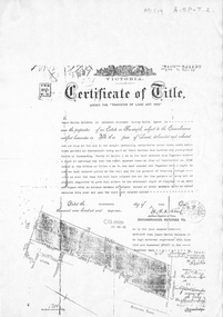
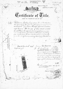
Document, Certificate of Title, 1/06/1908
... canterbury road... acres fronting on Canterbury Road, including Scott Street being... on Canterbury Road, including Scott Street being part of Crown Portion ...Photocopy of Certificate of Title Vol 3271 Fol 654003, 50 acres fronting on Canterbury Road, including Scott Street being part of Crown Portion 124, Parish of Nunawading, County of Bourke, in the name of William Scott, 20 June 1908; transfers to 8 October 1936 with notes of previous owners of parts of lot 124 from November 1858.scott street, mitcham, scott, william, polak, nelson, land subdivision, canterbury road, vermont, mitcham road, isaak, johnson, miller frederick, james, becker, lydia malvina, huffey, harry, graham, annie bella, langford, william allan, emily mary, caplin, ethel grace, armstrong, mary, cook, joseph allan, isabella, isaac william, mettzke, frederick oscar, whitmore, doris margaret, elizabeth, thomas, stephen, beach, william griffin, brown, hosking, bonnel, alphonse, saul, martin, richards, twose, richard frederick, charles, george, ham, cornelius job, sprigg, shaw, gavin, william barker, jane, mcclelland, david goodwin, thomas robert -
Whitehorse Historical Society Inc.
Document, Robert Collier Land, 1903
... Canterbury Road Blackburn...50 acres and house in Canterbury Road Blackburn to I.N... Tunstall. 50 acres and house in Canterbury Road Blackburn to I.N ...50 acres and house in Canterbury Road Blackburn to I.N. Cuttle for (pounds)590Papers relating to land dealings by Robert Collier of Springvale Road Tunstall. 50 acres and house in Canterbury Road Blackburn to I.N. Cuttle for (pounds)590collier, robert, t.r.b morton & coghill, maddock & jamison, canterbury road blackburn, freehold investment company of australia ltd -
Canterbury History Group
Photograph - Canterbury Mansions, Jan Pigot, 1993
... Canterbury Road... corner of Wattle Valley Road and Canterbury Road, Canterbury... Club Hotel Hotels Canterbury Post Office Wattle Valley Road ...Coloured photograph of Canterbury Mansions on the western corner of Wattle Valley Road and Canterbury Road, Canterbury. Built in 1889 for William Malone whose family owned it until the 1920s (known as Malone's Hotel and later Canterbury Club Hotel). Several other licensees until the local option poll of 1920 resulted in its closure as a licensed hotel. Continued as a guest house or private accommodation until its sale and redevelopment in the 1990s as professional suites.canterbury, canterbury mansions, malones hotel, canterbury club hotel, hotels, canterbury post office, wattle valley road, canterbury road, maling road, telegraph and light poles -
Whitehorse Historical Society Inc.
Document, History Of The Kindergarten
... canterbury road... of Canterbury and Terrara Roads, Vermont.... and Terrara Roads, Vermont. preschools vermont preschool canterbury ...Student Research on Vermont Pre-School, corner of Canterbury and Terrara Roads, Vermont.Student Research on Vermont Pre-School, corner of Canterbury and Terrara Roads, Vermont.Student Research on Vermont Pre-School, corner of Canterbury and Terrara Roads, Vermont.preschools, vermont preschool, canterbury road, vermont, terrara road -
 Whitehorse Historical Society Inc.
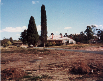
Photograph, Pioneer's House, S.W. Corner of Canterbury and Heatherdale Roads, 1987-88
... canterbury road mitcham.... Corner of Canterbury and Heatherdale Roads..... Corner of Canterbury and Heatherdale Roads. Pioneer's House ...Pioneer's House on Subdivision - Homestead Rise: S.W. Corner of Canterbury and Heatherdale Roads.pioneer's house, homestead rise subdivision, canterbury road mitcham, heatherdale road mitcham -
Canterbury History Group
Photograph - Old Timber House in Maling Road, Jan Pigot, 1992
... Maling Road, Canterbury, Victoria, Australia... way for new shops and car park. Canterbury Maling Road Timber ...Part of a set of 8 coloured photographs taken by Jan Pigot to record the demolition of some buildings in Maling Road to make way for new shops and car park.Old timber house on corner of Scott Street and Maling Road 1992. canterbury, maling road, timber house, scott street, shopping centres -
Canterbury History Group
Photograph - MMBW plan of station area c1910, c1910
... Canterbury Road...Copy of the MMBW plan of the Canterbury Station area...Canterbury History Group 142 Canterbury Road Canterbury ...Copy of the MMBW plan of the Canterbury Station area, shows a triangular section bounded by Canterbury and Maling Roadscanterbury, canterbury road, maling road, canterbury station, mmbw -
Whitehorse Historical Society Inc.
Document, Forest Hill, c2004
... of Springvale and Canterbury Roads and lived across the road. Forest... operated a general store on the corner of Springvale and Canterbury... on the corner of Springvale and Canterbury Roads and lived across ...Manuscript and typescript copy of description of life in Forest Hill in the 1940's and early 1950's.Manuscript and typescript copy of description of life in Forest Hill in the 1940's and early 1950's. The author's family operated a general store on the corner of Springvale and Canterbury Roads and lived across the road. Forest Hill was just ending its period as a rural community. Ref:: NP2401, NP2402, NP2403.Manuscript and typescript copy of description of life in Forest Hill in the 1940's and early 1950's. forest hill, richards, chris -
Whitehorse Historical Society Inc.
Map, Nunawading Shire, 1892
... (Mitcham) Bulleen to south of Canterbury Road; 3rd map Whitehorse... to Highbury Road, 2nd map (Mitcham) Bulleen to south of Canterbury... (Mitcham) Bulleen to south of Canterbury Road; 3rd map Whitehorse ...Photocopy of an enlargement of map of Shire of Nunawading showing landowners in 1892.Photocopy of an enlargement of map of Shire of Nunawading showing landowners in 1892. Covers Middleborough Road to Ringwood boundary. One map (Blackburn) from north of Whitehorse Road to Highbury Road, 2nd map (Mitcham) Bulleen to south of Canterbury Road; 3rd map Whitehorse Road to Highbury Road.Photocopy of an enlargement of map of Shire of Nunawading showing landowners in 1892. maps, shire of nunawading, blackburn, blackburn south, nunawading, forest hill, vermont, mitcham, vermont south -
Whitehorse Historical Society Inc.
Pamphlet, Stonestown, c. 1959
... Canterbury Road... corner of Canterbury and Springvale Roads Forest Hill... Hill Canterbury Road Forest Hill Stonestown Brochure ...Brochure on a proposed shopping centre on the southwest corner of Canterbury and Springvale Roads Forest Hill.Brochure on a proposed shopping centre on the southwest corner of Canterbury and Springvale Roads Forest HillBrochure on a proposed shopping centre on the southwest corner of Canterbury and Springvale Roads Forest Hill.shopping centres, springvale road, forest hill, canterbury road, forest hill, stonestown -
 Whitehorse Historical Society Inc.
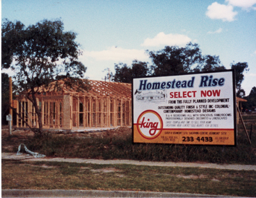
Photograph, Homestead Rise Sub-Division, 1987-88
... canterbury road mitcham.... corner of Canterbury and Heatherdale Roads..... corner of Canterbury and Heatherdale Roads. homestead rise ...Coloured photo of Homestead Rise Sub-Division on S.W. corner of Canterbury and Heatherdale Roads.homestead rise subdivision, canterbury road mitcham, heatherdale road mitcham -
Whitehorse Historical Society Inc.
Document, Kaufmans Road, 1896
... Canterbury Road Blackburn... by Kaufmans, Canterbury and Bakers Roads Blackburn, 1896.... and Bakers Roads Blackburn, 1896. Canterbury Road Blackburn Bakers ...Documents and contracts about the sale of land bounded by Kaufmans, Canterbury and Bakers Roads Blackburn, 1896.Documents and contracts about the sale of land bounded by Kaufmans, Canterbury and Bakers Roads Blackburn, 1896.Documents and contracts about the sale of land bounded by Kaufmans, Canterbury and Bakers Roads Blackburn, 1896.canterbury road blackburn, bakers road blackburn, schwab, henri samuel, morton, thomas richards burrowes, land sales, kaufmans road blackburn -
Whitehorse Historical Society Inc.
Map, Husband Road, Forest Hill, 1972
... Canterbury Road...Enlarged aerial photo of area between Canterbury... aerial photo of area between Canterbury and Husband Roads Forest ...Enlarged aerial photo of area between Canterbury and Husband Roads Forest Hill. Melbourne, 1972Enlarged aerial photo of area between Canterbury and Husband Roads Forest Hill. Melbourne, 1972Enlarged aerial photo of area between Canterbury and Husband Roads Forest Hill. Melbourne, 1972canterbury road, forest hill, husband road, forest hill, hylton crescent, forest hill, sapphire street, forest hill, opal street, forest hill, amber street, forest hill, willurah street, forest hill, nunawading swimming pool, aerial photographs -
 Whitehorse Historical Society Inc.
Photograph, Display House
... Canterbury Road...Black and white photo of Display House, Cnr Canterbury... and white photo of Display House, Cnr Canterbury & Deans Wood Road ...Black and white photo of Display House, Cnr Canterbury & Deans Wood Road, Forest Hill.display home, canterbury road, deans wood road, forest hill -
 Whitehorse Historical Society Inc.
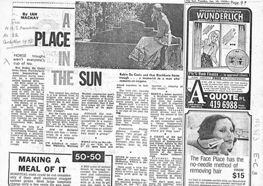
Newspaper - Article, Horse troughs, 10/01/1978
... canterbury road... and Canterbury Roads, bequested by George Bills to Australian horse... Costa at the corner of Blackburn and Canterbury Roads, bequested ...Article in 'The Sun' 1978 about the Blackburn horse trough found by Robin Da Costa at the corner of Blackburn and Canterbury Roads, bequested by George Bills to Australian horse owners. Bill came from Britain to Australia in 1859 and made a fortune. When he died in 1927 he left a large sum of money to prevent cruelty to animals. Robin is producing a pictorial history of Blackburn with the help of a grant from Nunawading Council.horse troughs, bills, george, blackburn road, blackburn, canterbury road, da costa, robin -
 Surrey Hills Historical Society Collection
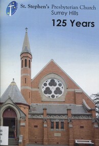
Book, St Stephen's Presbyterian Church Surrey Hills 125 years
... canterbury road..., Surrey Hills, on the corner of Canterbury and Warrigal Roads..., Surrey Hills, on the corner of Canterbury and Warrigal Roads..., on the corner of Canterbury and Warrigal Roads, Surrey Hills, dates back ...This brief description of St. Stephen's Presbyterian church, Surrey Hills, on the corner of Canterbury and Warrigal Roads, Surrey Hills, dates back to 1887 when Surrey Hills was a settled emerging community. It documents the changes from then, including the land and buildings, their ministry, hymn books and bibles, church camps, mission work, PMWU, men's activities, outreach groups, multi-cultural groups until 2012.This brief description of St. Stephen's Presbyterian church, Surrey Hills, on the corner of Canterbury and Warrigal Roads, Surrey Hills, dates back to 1887 when Surrey Hills was a settled emerging community. It documents the changes from then, including the land and buildings, their ministry, hymn books and bibles, church camps, mission work, PMWU, men's activities, outreach groups, multi-cultural groups until 2012.(mr) j. k. blogg, 1887, surrey hills, (mr) (rev) john ewing, (mr) (rev) alexander mcdonald, (mr) (rev) frederick darling, surrey college, kleppers orchard, balmoral crescent, st. stephen's presbyterian church, uniting church, (mr) (rev.) david innes, (rev) w. howden, (mr) (rev) david bradshaw, churches, canterbury road, warrigal road -
 Whitehorse Historical Society Inc.
Document, Map of Vermont & Mitcham
... canterbury road... bounded by Whitehorse , Mitcham, Canterbury and Heatherdale roads.... by Whitehorse , Mitcham, Canterbury and Heatherdale roads. land ...Copy of map showing land in Mitcham and Vermont areasCopy of map showing land in Mitcham and Vermont areas bounded by Whitehorse , Mitcham, Canterbury and Heatherdale roads.Copy of map showing land in Mitcham and Vermont areasland subdivision, whitehorse road, mitcham, heatherdale road, canterbury road, vermont, mitcham road -
 Whitehorse Historical Society Inc.
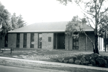
Photograph, Pioneer's House, S.W. corner of Canterbury and Heatherdale Roads, Mitcham, C.1987-88
... canterbury road mitcham... Rise, S.W. corner of Canterbury and Heatherdale Roads, Mitcham..... corner of Canterbury and Heatherdale Roads, Mitcham. Coloured ...Coloured photo of Pioneer's House. Subdivision: Homestead Rise, S.W. corner of Canterbury and Heatherdale Roads, Mitcham.pioneer's house, homestead rise subdivision, canterbury road mitcham, heatherdale road mitcham -
 Whitehorse Historical Society Inc.
Pamphlet, Artist's Camp, 1987
... of Canterbury Road, between the present sites of Bowater Scott and Box... property on Gardiners Creek, south of Canterbury Road, between... of Canterbury Road, between the present sites of Bowater Scott and Box ...Pamphlet on Box Hill Artists CampPamphlet on Box Hill Artists Camp and the move to Eaglemont, near Heidelberg when the term Heidelberg School began to be used, in 1988. The Box Hill Camp was made on David Houston's property on Gardiners Creek, south of Canterbury Road, between the present sites of Bowater Scott and Box Hill Golf Club.Pamphlet on Box Hill Artists Camp artists camps, roberts, tom, mccubbin, frederick, streeton, arthur, conder, charles, abrahams, louis, houston, david, gardiners creek -
 Whitehorse Historical Society Inc.
Photograph, Vermont Shops C.1967, C.1967
... canterbury road...Coloured photo of Vermont Shops on corner of Canterbury.... canterbury road vermont boronia road shambrook tim ...Part of Tim Shambrook's Collection for 'This is Vermont'. Not used.Coloured photo of Vermont Shops on corner of Canterbury and Boronia Roads, Vermont, in 1967. Looking south to Boronia Road.canterbury road, vermont, boronia road, shambrook, tim -
Whitehorse Historical Society Inc.
Document, History of Vermont State School, 1969
... canterbury road... of Delaney's Road and McGhee's Road, now Canterbury and Mitcham Roads.... on corner of Delaney's Road and McGhee's Road, now Canterbury ...The History of Vermont State School, a committee was formed early 1869 and the School opened July, 1869.The History of Vermont State School, a committee was formed early 1869 and the School opened July, 1869. First Headmaster was 18 year old John Brown. The School was situated on corner of Delaney's Road and McGhee's Road, now Canterbury and Mitcham Roads.The History of Vermont State School, a committee was formed early 1869 and the School opened July, 1869. primary schools, vermont state school, no. 1022, brown, john, jane elizabeth, cooney, joseph, drummond, miss, rooks, abraham, smith, william, mcghees road, mitcham, delaney's road, mitcham road, vermont, canterbury road, boyle, david, mcsporran, mcclare -
 Surrey Hills Historical Society Collection
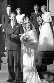
Work on paper - Photograph, Margaret Black's wedding 1st May 1948, 1948
... Canterbury Road, Surrey Hills, Victoria, Australia ...Margaret Johnson was born and raised in the country. She came to Melbourne to attend secondary school at age eleven. She stayed with the family of her uncle, Dr Carrington, in their home / surgery still located at 174 Union Road, the Surrey Hills Medical Centre. Later, whilst waiting to commence her kindergarten training course, she met Jessie Black and they became firm friends and it was through Jessie that Margaret met Jessie’s brother and her future husband, Thorby Black. The Black family had been residents of Mont Albert for many years and Thorby was in the air force at the time. Margaret and Thorby were married at St Stephens Presbyterian Church in Surrey Hills on 1 May 1948. Her wedding dress was bought at Canns on the corner of Elizabeth Street & Flinders Lane. It was one in an exhibition held as part of a Surrey Hills Festival in the early 2000's. Like others in the exhibition, it no longer had its train and the sleeves have been shortened. Margaret recalled that after her wedding she wore it as an evening dress. Her bridesmaids’ dresses were a little unusual for the time, as they too were white and their flowers were subdued pink and blue. According to Margaret, the popular fashion was for brightly coloured dresses and bright flowers for the bridesmaids. The positioning of the garlands of flowers in their hair was also unusual. They were placed at the back so that the congregation could see them during the ceremony. Housing was in very short supply in the years following the war, so after they were married, Margaret and Thorby moved into a small flat created at Dr Carrington’s surgery. They later moved to a house built in 1926 in Black Street, Mont Albert, which continued to be Margaret’s home until her death. weddings, mrs margaret black, miss margaret johnson, mr thorby black, st stephens presbyterian church, bridal wear