Showing 1854 items
matching connected
-
 Geoffrey Kaye Museum of Anaesthetic History
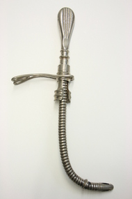
Equipment - Tube, Endotracheal, Kuhn, Circa 1900
The evolution of endotracheal intubation for anaesthesia was a slow process. Franz Kuhn (1806-1929), a head and neck surgeon working in Kassel, Germany, between 1902 and 1911, is said to have done more than any other to obtain general recognition for endotracheal anaesthesia. Kuhn's tube, is a flexible metal one inserted on a stilette which was then withdrawn. The tube was then secured with an elastic neck strap and connected by a rubber tube to a Trendelenburg cone. The glottis was packed with oiled gauze. Metal spiral tube with elaborate handle at one end and rounded at the other. There is a metal clasp at the base of the handle which all forms part of the endotracheal tube. Inside the tube is a curved metal piece that functions as an introducer.kuhn, endotracheal, airway, intubation -
 Warrnambool and District Historical Society Inc.
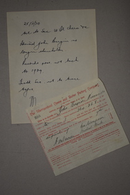
Documents, 1 1909 .2 1970
These items are connected to the Warrnambool Cheese and Butter Factory. One is a share certificate from the company issued in 1909 to John Bergin of Nirranda and the other is a 1970 handwritten note, possibly from the Tait legal firm in Warrnambool indicating that John Bergin was no longer a shareholder. He may have been deceased or the shares may have been sold previously. The Warrnambool Cheese and Butter factory in Allansford is the oldest surviving dairy company in Australia. It was established in 1888 and is now operated by the Canadian firm Saputo. These items are of minor interest as mementoes of the early share certificates of the Warrnambool Cheese and Butter Factory, a major dairying business in the Warrnambool district for over 100 years. .1 This is a certificate extracted from a booklet of similar certificates. The printing is red with handwritten material inserted in black ink. There is a seal on the right side of the certificate. .2 This is a sheet of white paper with a handwritten note regarding the certificate described above. John Bergin Nirrandawarrnambool cheese and butter factory company -
 Federation University Historical Collection
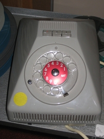
Modum, Ericovox Loud Speaking Telephone, c1959
Ericsson had designed its first speakerphone in the 1930s, it was in 1959 that the company made a major breakthrough with the development of the Ericovox, according to the website EricssonHistory.com. Until then, speakerphones experienced problems with ambient noise and echoes. The pyramid-shaped Ericovox featured an amplification system that addressed the background noise problems by automatically amplifying the audio in the direction of the speaker, decreasing it in other directions. The Ericovox did not have a handset or a ringer, but could be connected with a telephone, such as the Ericofon. 9http://www.ehow.com/info_12141155_ericsson-phones-1950s.html) Grey plastic loud speaking telephone with dial, three buttons, and a plug to connect to the telephone system. The phone is an Ericovox 1/DBe1225/1 A18 7516telephone, ericovox -
 Hume City Civic Collection
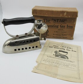
Domestic object - Self-Generating Gas Iron, The "STAR" Self-Generating Gas Iron
This iron was given to Isobel and Stan Campbell by another woman in Boort Victoria pre 1999 as per the letter attached with the Donation form. These irons were manufactured in Australia as per the printing on the cardboard box and instruction sheet. These self-generating gas irons used methylated spirits in the small tank at the back of the iron. The irons would have been used prior to electricity being available to be connected to a house and used for ironing clothes and other woven material items used by the members of the household.Brown cardboard box with separate lid with black printing on the front and back of box and lid. A heavy silver iron with 13 holes along each side there is a black handle screwed to top of iron and a small round container attached to the back. An instruction sheet. Box front and back - The "STAR"/Self-Generating Gas iron/(Registered)/Is Made In Australia!/By Australian Workers!/From Australian Material!/ Instruction sheet - MADE IN AUSTRALIA/.../The "STAR' is the most economical Iron ever put on the Market , and/being manufactured of the best materials only, will last a life-time./...social history, domestic appliance, irons, george evans collection, isobel campbell, 1990s -
 Unions Ballarat
The Assault on Reason, Gore, Al, 2007/2008
From the publisher: "A visionary analysis of how the politics of fear, secrecy, cronyism, and blind faith has combined with the degradation of the public sphere to create an environment dangerously hostile to reason." The book strongly critique of the Bush administration. Contents: Introduction -- 1: Politics of fear -- 2: Blinding the faithful -- 3: Politics of wealth -- 4: Convenient untruths -- 5: Assault on the individual -- 6: National insecurity -- 7: Carbon crisis -- 8: Democracy in the balance -- 9: Well-connected citizenry -- Conclusion: Rebirth of democracyRelevance to politics in the United States, Iraq War, events around 9/11 and the George W. Bush government (2000-2008).Paper; book. Front cover: coloured image of the US flag (background); blue, white and red lettering.Front cover: author's name and book title.btlc, ballarat trades hall, ballarat trades and labour council, united states of america, bush, george, iraq war, 9/11, national security - usa, politics, government, democracy, citizenship -
 Sunbury Family History and Heritage Society Inc.
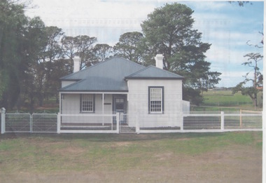
Photograph, Former Engineer's Cottage
The building was the residence of the engineer who was responsible of managing the early electric supply that was installed in Sunbury in 1909. The town's power supply put an end to gas lighting that had been used and homes had the benefit of having electricity connected to their homes. In 1926 the State Electricity Commission took over supplying electrical power to Sunbury. The cottage is now a private home and the power house building has been demolished. he complex occupied land on the corner of Jackson and Shields Street.At the time the electric supply was installed in Sunbury in 1909, few small country towns had electric power connected.A non-digital scanned coloured photograph with a narrow white border of a small double fronted wooden cottage with a corrugated iron roof with trees growing behind the building.electricity, engineer's corrage, jackson street, shields street, power supplies -
 Orbost & District Historical Society
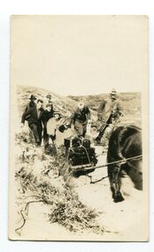
black and white photograph, first half 20th century
Access to the cottages at the lighthouse was difficult and the horse-drawn sled was in use until the 1940s. It was used to haul personal goods as wel as those needing medical attention at far-off Orbost. This photograph could be connected with the Gledhills in the 1930s when a medical emergency necessitated a removal to Orbost. Dr Nettleton was the doctor at Orbost at that time. (there could be a link through donor) Point Hicks is claimed to be Captain James Cook’s first sighting of mainland Australia. The lighthouse was built on the point during 1887 and 1888 and commenced operation in 1890, built from concrete and with timber keepers quarters. It was connected to mains electricity in 1965, and then to solar power recently. Originally access to Point Hicks was by sea. In 1920 a return trip, by land to Cann River, 47 kilometres away from the light station, took two days. By 1946 the journey had been reduced to 36 hours by a combination of horse and jeep. During the early 1950s it was still a 12-hour ordeal. The light no longer works, it was turned off 21 years ago and the Point Hicks lighthouse is now powered by a much smaller, more modern light. the lightkeepers' cottages are used for tourist accommodation.This photograph is associated with Point Hicks, a historically important lightstation in East Gippsland.A small black / white photograph of a horse dragging a sled with suitcases on it. There are seven people walking behind, one holding the reins. They are waalking through a sand dune.on label on back - "Bring Out to Light House keeper from Point Hicks"point-hicks-lighthouse -
 Bendigo Military Museum
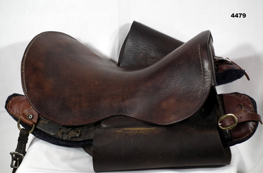
Equipment - SADDLE, 1916
British military saddle as used in WW1. The saddles were designed to have interchangeable parts, making them easy to repair.Military steel arch brown leather saddle. Tree is made of wood with thick blue felt pads and leather attachments. Neither is original. Various brass rings located on the saddle for attaching sundry equipment. Brown leather strap with silver coloured metal buckle attached to the rear right hand side of the tree. No stirrups, stirrup leathers or girth attached. The leather seat covers the frame of the saddle between the front and rear arches and is connected to them by khaki webbing and leather laces. Leather sweat flaps on each side. Leather straps and brass buckles on the front of each pad.Stamped on the front of the seat: '1916, 13'. Stamped on each sweat flap: '1916, 13'.military equipment, saddle, horse equipment, transport -
 Ballarat Tramway Museum
Newspaper, The Courier Ballarat, "A growing, young ambition to pull a tram", 26/05/2003 12:00:00 AM
Newspaper cutting from page 2 of The Courier, Ballarat, 26 May 2003, titled "A growing, young ambition to pull a tram", reporting on the event at Lake Wendouree the previous day. Photograph features Anna Howley from the University of Ballarat pulling on the rope connected to the tram on the west side of Gardens Loop. Tram has the "Power 103.1 FM" banner on the front. Photo by Ian Wilson of the Ballarat Courier and report by Catherine Best. Quotes Allister Morrison of the Young Ambition and that they raised $8,000 for Pinarc Support Services. See also Reg. Item 2451 for event programme.date of newspaper cutting and page number in pencil and bottom of sheet.young ambition, tram pull, btm, rotary ballarat -
Maldon Vintage Machinery Museum Inc
Steam Engine, 1877
Restored by Maldon Flywheelers Association. Originally owned and used by Zemster Brothers of "Brook Mount" Shellbourne.Known as "Aunty Jack"Large 4 wheeled 9 HP single cylinder (horizontal) steam engine, designed to be towed. Front wheels smaller than rear. Folding smoke stack with spark arrestor. Fire box and smoke stack painted black, boiler and steam cylinder green, wheels grey. In working order but engine is connected to an independent steam/air source to be operated for display purposes. 150 cm flywheel on LHS looking forward toward the front. Timber front turntable and back brake pad assembly. Brass water drain tap on firebox. Also other brass fittings on firebox.On brass ring near top of firebox:- "Serial No. 5672, Marshal Sons & Co. / Limited / Engineers / Gainsborough England". Metal plate on front turntable:- "Restoration of the Front Undercarriage / and retubing of the boiler by / Castlemaine Technical School / 1979". Cast in relief on wheel hubs:- "Marshal Sons & Co. Gainsborough".machinery - engines - steam -
 Melbourne Tram Museum
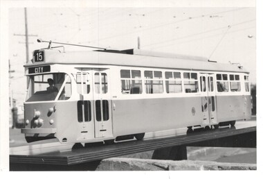
Photograph - Set of 4 Black & White Photograph/s, c1973
Set of four Black and White photographs of the model of prototype 1041 at Preston Workshops. .1 - photographed in the open area within Preston Workshops to give the impression that it was connected to the overhead. Showing Route 15, City - 110H x 165W .2 - Similar photograph but without the driver. Showing Route 88, East Preston - 166H x 217W (not imaged) .3 - Similar photograph, showing Route 64, E. Brighton - 110H x 165W .4 - Similar photograph, possibly different colour, appears to be darker, showing Mont Albert Route 42 - 124H x 203W.trams, tramways, 1041, preston workshops, models, tram 1041 -
 Geoffrey Kaye Museum of Anaesthetic History
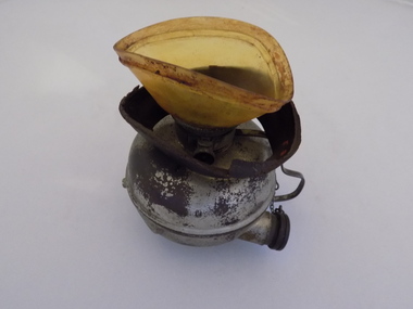
Equipment - Inhaler, Hewitt, George Barth & Co. Ltd, c. 1895
Sir Frederic W. Hewitt (1857-1916), an accomplished and well respected English anesthesiologist, was an expert in the function and use of the Clover Ether Inhaler. In 1901, Hewitt described his modification of the Clover Inhaler. Often referred to as the Hewitt Wide-Bore Inhaler, Dr. Hewitt introduced changes in order to make it easier to breathe through the device and improve the ventilation of oxygen and carbon dioxide. In 1901, Hewitt was recruited to anesthetize King Edward VII for emergency abdominal surgery. This was just a day or so before the new King was to be coronated. He recovered well, and Hewitt became the first anesthesiologist ever to be knighted. (Source: Wood Library Museum)Tall black round topped box with brass hooks at the sides and brass hinges at rear. There is a brown fabric handle on the top. The box has red padding inside the lid and red lining inside the base and sides. There is a round section in the base of the box for holding the round clear glass bottle for ether. There is also a ellipse-shaped metal inhaler on small metal base with a thin metal handle and pipe with bakelite plug attached via a small metal chain. A brown mask is made of brown leather and celluloid which is connected to the inhaler. There is a metal ether measure for pouring the ether.On notecard in box: (B) HEWITT'S INHALER 1895, MADE BY GEO. BARTH & CO LTD., ADVERTISED AS THE SOLE MAKERS OF THE INHALER AND RECOGNISED BY HEWITT IN HIS TEXT BOOK - ANAESTHETICS AND THEIR ADMINISTRATION - AS THE MAKER OF HIS INHALER. / GIVEN BY DR. E.S. HOLLOWAY IN 1951, WHO ACQUIRED MUCH OF HOWARD JONES' EQUIPMENT AFTER THE LATTER'S DEATH. Stamped on underside of glass bottle in a circle: WUBW [illegible] Blue sticker on inhaler: O.2.13. Printed on inhaler under handle: Geo Barth [illegible] / SOL [illegible] Printed on body of inhaler: Full Printed on body of inhaler: 1/2 Printed on inside of leather mask: F35hewitt, sir frederic, jones, howard, inhaler, geo. barth & co. ltd., ether -
 Robin Boyd Foundation
Document - Script, Robin Boyd, The Flying Dogtor. Episode 51 The Well, 1963
A sea serpent or lake monster had been frightening people in the Snowy Mountains area. The Flying Dogtor discovered that it was only Crafty Carson Carpetbag, the sneaky snake in disguise. But Crafty and Old Man Redback caught the Dogtor, and held him in a cave where there was a dark, cold well of water so deep that they said it connected with the bottom of the ocean. And the Dogtor, helplessly bound up with ropes, fell into this well. It seemed to the ministry, that the Dogtor had been swallowed by the serpent, and they were to organise a glorious state funeral.The Flying Dogtor" series was broadcast on Australian Television Network (later becoming the Seven Network) between February and April 1964 (see item D254 for schedule).Typewritten, carbon copy, foolscap, 2 pagesHandwritten pencil edits and additions.the flying dogtor, robin boyd, crawford productions, manuscript -
 Melbourne Legacy
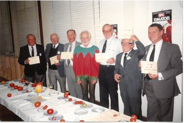
Photograph - Photo, Legatee function, c.1989
Photos of Legatees at an event that appears connected to SPC and examining different types of tomatoes. One man is dressed in a tomato costume. Names and date unknown. It could be a fundraising opportunity in conjunction with SPC. See also 00340 which are competition headings such as Best Cluster, Grand Champion Tomato, Biggest Tomato, Littlest Tomato, Best Decorated Tomato, Squarest Tomato, Supreme Champion Non Tomato, Most Peculiar Shaped Tomato. Legatee Chas Wilks is in one photo so it may be when he is President in 1989.A record of a social gathering with possible fundraising aspects.Colour photo x 3 of a Legatee function with a focus on tomatoes.legatee event, function -
 Kew Historical Society Inc
Plan - Subdivision Plan, Riversdale Estate, 1939
The Kew Historical Society collection includes almost 100 subdivision plans pertaining to suburbs of the City of Melbourne. Most of these are of Kew, Kew East or Studley Park, although a smaller number are plans of Camberwell, Deepdene, Balwyn and Hawthorn. It is believed that the majority of the plans were gifted to the Society by persons connected with the real estate firm - J. R. Mathers and McMillan, 136 Cotham Road, Kew. The Plans in the collection are rarely in pristine form, being working plans on which the agent would write notes and record lots sold and the prices of these. The subdivision plans are historically significant examples of the growth of urban Melbourne from the beginning of the 20th Century up until the 1980s. A number of the plans are double-sided and often include a photograph on the reverse. A number of the latter are by noted photographers such as J.E. Barnes.The Riversdale Estate in Hawthorn created a subdivision of 20 allotments bordering on Riversdale Road and Riversdale Court (which was created by the subdivision). The Locality Plan at right lists the major public buildings in the area: Burnely Horticultural Gardens, Hawthorn Tram Depot and Railway Station, Scotch College and the River Yarra and The Boulevard.subdivision plans - hawthorn, riversdale estate -
 Kew Historical Society Inc
Plan - Subdivision Plan, Corsewall Estate, Hawthorn, 1938
The Kew Historical Society collection includes almost 100 subdivision plans pertaining to suburbs of the City of Melbourne. Most of these are of Kew, Kew East or Studley Park, although a smaller number are plans of Camberwell, Deepdene, Balwyn and Hawthorn. It is believed that the majority of the plans were gifted to the Society by persons connected with the real estate firm - J. R. Mathers and McMillan, 136 Cotham Road, Kew. The Plans in the collection are rarely in pristine form, being working plans on which the agent would write notes and record lots sold and the prices of these. The subdivision plans are historically significant examples of the growth of urban Melbourne from the beginning of the 20th Century up until the 1980s. A number of the plans are double-sided and often include a photograph on the reverse. A number of the latter are by noted photographers such as J.E. Barnes.This is a second, more complete version of the Corsewall Estate subdivision that is held by the Society. The Coreswall Estate was a subdivision, bordering on Barkers Road and Auburn Road, which created Corsewall Close. This relatively late subdivision included 29 allotments. The subdivision plan includes the dimensions of each lot as well as the width of the existing and projected roads and turning circles. The Corsewall Close Precinct is now listed on the Victorian Heritage Database (HO147) and is noted for its ‘consistent flat-type development over the entire street, which has been cleverly designed to make multi-unit dwellings appear as single buildings’. In this second version of the plan, the rarity of this late subdivision is emphasised by the auctioneers. The original plan must have contained a photograph, which is unfortunately truncated here.subdivision plans - hawthorn, corsewall estate -
 Kew Historical Society Inc
Plan - Subdivision Plan, Mount Ida Estate, 1925
The Kew Historical Society collection includes almost 100 subdivision plans pertaining to suburbs of the City of Melbourne. Most of these are of Kew, Kew East or Studley Park, although a smaller number are plans of Camberwell, Deepdene, Balwyn and Hawthorn. It is believed that the majority of the plans were gifted to the Society by persons connected with the real estate firm - J. R. Mathers and McMillan, 136 Cotham Road, Kew. The Plans in the collection are rarely in pristine form, being working plans on which the agent would write notes and record lots sold and the prices of these. The subdivision plans are historically significant examples of the growth of urban Melbourne from the beginning of the 20th Century up until the 1980s. A number of the plans are double-sided and often include a photograph on the reverse. A number of the latter are by noted photographers such as J.E. Barnes.The Mount Ida Estate was a subdivision of fifty-two residential allotments bordering Tooronga Road, Leura Grove, Constance Street, and Mount Ida Avenue in Hawthorn East. The report of the sale of the Estate in The Argus (21 September) claimed that over 1,000 people attended the auction and that all allotments were sold on the day. On the other side of Constance Street, the plan identifies the ‘Eastern Recreation Reserve’ (now Anderson Park).subdivision plans - hawthorn -
 Kew Historical Society Inc
Plan - Subdivision Plan, Jaques Estate, 1927
The Kew Historical Society collection includes almost 100 subdivision plans pertaining to suburbs of the City of Melbourne. Most of these are of Kew, Kew East or Studley Park, although a smaller number are plans of Camberwell, Deepdene, Balwyn and Hawthorn. It is believed that the majority of the plans were gifted to the Society by persons connected with the real estate firm - J. R. Mathers and McMillan, 136 Cotham Road, Kew. The Plans in the collection are rarely in pristine form, being working plans on which the agent would write notes and record lots sold and the prices of these. The subdivision plans are historically significant examples of the growth of urban Melbourne from the beginning of the 20th Century up until the 1980s. A number of the plans are double-sided and often include a photograph on the reverse. A number of the latter are by noted photographers such as J.E. Barnes.The Jaques Estate was a small subdivision of eight residential allotments bordering Jaques Street and Barkers Road in what is now Hawthorn East. Advertised in The Argus as being in ‘Upper Hawthorn’ the subdivision was claimed to include: ‘charming villa sites in excellent situations, with every convenience available, and with superior homes surrounding’.subdivision plans - hawthorn, jaques estate -
 Kew Historical Society Inc
Plan - Subdivision Plan, Houghton Street & Buchanan Avenue, Balwyn North, ca. 1906
The Kew Historical Society collection includes almost 100 subdivision plans pertaining to suburbs of the City of Melbourne. Most of these are of Kew, Kew East or Studley Park, although a smaller number are plans of Camberwell, Deepdene, Balwyn and Hawthorn. It is believed that the majority of the plans were gifted to the Society by persons connected with the real estate firm - J. R. Mathers and McMillan, 136 Cotham Road, Kew. The Plans in the collection are rarely in pristine form, being working plans on which the agent would write notes and record lots sold and the prices of these. The subdivision plans are historically significant examples of the growth of urban Melbourne from the beginning of the 20th Century up until the 1980s. A number of the plans are double-sided and often include a photograph on the reverse. A number of the latter are by noted photographers such as J.E. Barnes.A hand-drawn subdivision plan listing six blocks bounded by Houghton Street, Doncaster Road, Buchanan Avenue and Maud Street, North Balwyn. Written on the plan of subdivision are the lot numbers, the dimensions of the blocks and the price at which two lots were for sale or had been sold for.subdivision plans - balwyn -
 Kew Historical Society Inc
Plan - Subdivision Plan, Doona Estate, Toorak, 1929
The Kew Historical Society collection includes almost 100 subdivision plans pertaining to suburbs of the City of Melbourne. Most of these are of Kew, Kew East or Studley Park, although a smaller number are plans of Camberwell, Deepdene, Balwyn and Hawthorn. It is believed that the majority of the plans were gifted to the Society by persons connected with the real estate firm - J. R. Mathers and McMillan, 136 Cotham Road, Kew. The Plans in the collection are rarely in pristine form, being working plans on which the agent would write notes and record lots sold and the prices of these. The subdivision plans are historically significant examples of the growth of urban Melbourne from the beginning of the 20th Century up until the 1980s. A number of the plans are double-sided and often include a photograph on the reverse. A number of the latter are by noted photographers such as J.E. Barnes.The Doona Estate subdivision of 1929 created 11 new allotments bordered by Glenferrie Road, Stonnington Place, Cross and Church Streets. On the right of the plan, the location of ‘State Govt. House’ is noted. Stonnington was to be maintained as Victoria’s Government House until 1931, two years after the Doona Estate subdivision was released.subdivision plans - toorak, doona estate -
 Kew Historical Society Inc
Plan - Subdivision Plan, Auburn Heights Estate, 1921
The Kew Historical Society collection includes almost 100 subdivision plans pertaining to suburbs of the City of Melbourne. Most of these are of Kew, Kew East or Studley Park, although a smaller number are plans of Camberwell, Deepdene, Balwyn and Hawthorn. It is believed that the majority of the plans were gifted to the Society by persons connected with the real estate firm - J. R. Mathers and McMillan, 136 Cotham Road, Kew. The Plans in the collection are rarely in pristine form, being working plans on which the agent would write notes and record lots sold and the prices of these. The subdivision plans are historically significant examples of the growth of urban Melbourne from the beginning of the 20th Century up until the 1980s. A number of the plans are double-sided and often include a photograph on the reverse. A number of the latter are by noted photographers such as J.E. Barnes.The name ‘Auburn Heights Estate’, was handwritten on the subdivision plan, and included 23 lots in Auburn Road and Wright and View Streets, Hawthorn. Most of the houses built on the lots that were sold still exist. The house built on number 8 View Street is a contemporary exception. The subdivision included an existing home at number 17 View Street.subdivision plans - hawthorn, auburn heights estate -
 Kew Historical Society Inc
Plan - Subdivision Plan, Corsewall Estate, 1938
The Kew Historical Society collection includes almost 100 subdivision plans pertaining to suburbs of the City of Melbourne. Most of these are of Kew, Kew East or Studley Park, although a smaller number are plans of Camberwell, Deepdene, Balwyn and Hawthorn. It is believed that the majority of the plans were gifted to the Society by persons connected with the real estate firm - J. R. Mathers and McMillan, 136 Cotham Road, Kew. The Plans in the collection are rarely in pristine form, being working plans on which the agent would write notes and record lots sold and the prices of these. The subdivision plans are historically significant examples of the growth of urban Melbourne from the beginning of the 20th Century up until the 1980s. A number of the plans are double-sided and often include a photograph on the reverse. A number of the latter are by noted photographers such as J.E. Barnes.The Corsewall Estate was a subdivision, bordering on Barkers Road and Auburn Road, which created Corsewall Close. This relatively late subdivision included 29 allotments. The subdivision plan includes the dimensions of each lot as well as the width of the existing and projected roads and turning circles. The Corsewall Close Precinct is now listed on the Victorian Heritage Database (HO147) and is noted for its ‘consistent flat-type development over the entire street, which has been cleverly designed to make multi-unit dwellings appear as single buildings’.subdivision plans - hawthorn, corsewall estate -- hawthorn (vic.) -
 Kew Historical Society Inc
Plan - Subdivision Plan, Pointed Firs Estate, 1936
The Kew Historical Society collection includes almost 100 subdivision plans pertaining to suburbs of the City of Melbourne. Most of these are of Kew, Kew East or Studley Park, although a smaller number are plans of Camberwell, Deepdene, Balwyn and Hawthorn. It is believed that the majority of the plans were gifted to the Society by persons connected with the real estate firm - J. R. Mathers and McMillan, 136 Cotham Road, Kew. The Plans in the collection are rarely in pristine form, being working plans on which the agent would write notes and record lots sold and the prices of these. The subdivision plans are historically significant examples of the growth of urban Melbourne from the beginning of the 20th Century up until the 1980s. A number of the plans are double-sided and often include a photograph on the reverse. A number of the latter are by noted photographers such as J.E. Barnes.An almost identical plan of the ‘Pointed Firs Estate’ is in the State Library of Victoria. The plan unusually uses a photograph to show the panoramic views from the Estate. A prospective purchaser could expect to look across the Yarra Valley to Eaglemont and Heidelberg. The 36 lots advertised for sale faced Doncaster Road, Houghton Street, Maud Street and Thackray Street in Balwyn North.subdivision plans - balwyn, pointed firs estate -
 Kew Historical Society Inc
Plan - Subdivision Plan, Lodged Plan No.6518, 1920-1940
The Kew Historical Society collection includes almost 100 subdivision plans pertaining to suburbs of the City of Melbourne. Most of these are of Kew, Kew East or Studley Park, although a smaller number are plans of Camberwell, Deepdene, Balwyn and Hawthorn. It is believed that the majority of the plans were gifted to the Society by persons connected with the real estate firm - J. R. Mathers and McMillan, 136 Cotham Road, Kew. The Plans in the collection are rarely in pristine form, being working plans on which the agent would write notes and record lots sold and the prices of these. The subdivision plans are historically significant examples of the growth of urban Melbourne from the beginning of the 20th Century up until the 1980s. A number of the plans are double-sided and often include a photograph on the reverse. Reconciling this hand-drawn subdivision plan with a modern map of the area is initially a challenge due to a change of street names. Argyle Road in the centre of the subdivision was to be renamed Deepdene Road, and the street named Deepdene Road on the plan was to become Deepdene Place. Of interest is the nursery on the corner of Argyle and Whitehorse Roads. During this period there were a number of nurseries servicing the Kew and Balwyn areas. The subdivision was essentially of the land formerly occupied by the house 'Deepdene'.subdivision plans - balwyn, deepdene, whitehorse road -- deepdene (vic.), deepdene road -- deepdene (vic.), burke road -- deepdene (vic.) -
 Royal Australian and New Zealand College of Obstetricians & Gynaecologists (RANZCOG)
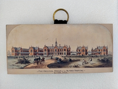
Print - Colour print, Charles Webb, Original design of the Alfred Hospital, c. 1870
"The Alfred Hospital was founded in 1869 as a result of the work of a number of Melbourne doctors who fought a long and internecine battle for an additional general hospital treating its first patient in 1871. Prahran Council donated a parcel of low lying land for the provision of a Hospital. In 1870, the Melbourne architect, Charles Webb, won the competition to design The Alfred Hospital with his revolutionary design. Webb incorporated the "Nightingale" design principles by designing large light filled pavilions as wards connected by covered corridors or walkways." (Alfred Health)Small colour print mounted on a wood block. Print depicts a series of five red brick buildings at centre, with a dirt road snaking up from the left foreground to the front of the central building. A man is driving a two horse buggy along the dirt road towards the buildings. The landscape on either side of the road consists of grassland and low vegetation, as well as four shallow circular pits (two on either side) which contain vegetation. There are two figures in the right foreground cutting grass with scythes. A flock of birds is visible in the sky in the central background, above the main hospital building. Text printed below image reads 'THE ORIGINAL DESIGN OF THE ALFRED HOSPITAL/By C.Webb, Arckitect (sic)'. The back of the wooden block to which the print is affixes is painted black, and a circular hook has been attached to the centre back of the block for hanging the artwork. The hook is gold coloured, and attached using two gold coloured pins and a small strap. Handwriting at bottom right of the back of the object reads 'ANN TAVELL''THE ORIGINAL DESIGN OF THE ALFRED HOSPITAL/By C.Webb, Arckitect (sic)' -
 Stawell Historical Society Inc
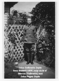
Photograph, Doyle Family Photos with Indentifying names -- 7 Photos
Doyle Family Group photographs plus others. Think a mistake in photograph of soldier in WW1 uniform (photo 2) as more likely Peter Pagan Doyle as John born 1909. Photo 1. Portrait of "John Galbraith Doyle born Stawell 1909, only child of Marion (Galbraith) and John Pagan Doyle". Photo 2. of soldier & portrait photo. "John Galbraith Doyle born Stawell 1909 only child of Marion (Galbraith) and John Pagan Doyle". Photo 3. of wedding group "Origin unknown. At the right is Marion Galbraith, b1881 in Stawell, dau. of Peter Galbraith. The man to her right is thought to be John Pagan Doyle". Photo 4. of house. "Home of Peter Galbraith and family, possibly Patrick Street Stawell. with family members arrayed" Photo 5. family group "Galbraith family at Stawell. Mr. Peter Galbraith, his wife Margaret (Cameron), and 4 children -L-R Norman, Marion, Afton and (in front) Harold. Photo 6. of 8 men. "Source unknown, but possible connected with Stawell of Mines or may be part of Peter Galbraith's assay business. People second from left, back row and second from left, front row appears to be sons of Peter Galbraith". Photo 7. "Marion (Galbraith) Doyle and John Galbraith Doyle (b. Stawell 1909)". Marion only daughter of Peter & Margaret Galbraith nee Cameron born Stawell 1881. Marion married John Pagan Doyle who was Science Director of School of Mines, Stawell 1909. Eight black and white photographs of Galbraith Doyle and Pagan Doyle Family. Two photographs of a soldier in WW1 uniform. (Think a mistake as possible Peter Pagan Doyle). Third photo is of a group of 13 people at a wedding. Fourth photo of a weather board house with a veranda and garden and people on veranda and in garden. Fifth photo Family group. Sixth photo 8 men holding equipment associated with mining but formally dressed. Eight photo of a woman and child holding a cat. Note a mistake on 2 photos, the captions state John Galbraith Doyle was born 1909 at Stawell but he is shown in a WW1 uniform which cannot be him. The soldier must be his father John Pagan Doyle who enlisted 1915 at Stawell. Photo 1. of "John Galbraith Doyle born Stawell 1909, only child of Marion (Galbraith) and John Pagan Doyle". Photo 2. of soldier & portrait photo. "John Galbraith Doyle born Stawell 1909 only child of Marion (Galbraith) and John Pagan Doyle". Photo 3. of wedding group "Origin unknown. At the right is Marion Galbraith, b1881 in Stawell, dau. of Peter Galbraith. The man to her right is thought to be John Pagan Doyle". Photo 4. of house. "Home of Peter Galbraith and family, possibly Patrick Street Stawell. with family members arrayed" Photo 5. family group "Galbraith family at Stawell. Mr. Peter Galbraith, his wife Margaret (Cameron), and 4 children -L-R Norman, Marion, Afton and (in front) Harold. Photo 6. of 8 men. "Source unknown, but possible connected with Stawell of Mines or may be part of Peter Galbraith's assay business. People second from left, back row and second from left, front row appears to be sons of Peter Galbraith". Photo 7. "Marion (Galbraith) Doyle and John Galbraith Doyle (b. Stawell 1909)".stawell -
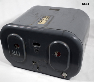 Bendigo Military Museum
Magazine - MAGAZINE, FILM, Williamson Manufacturing Co Ltd
This photographic magazine attaches to the gear box universal ( see cat 4531). As an assembly, the type F22 aerial camera came into RAF and RAAF service c1942. It was used by the RAF over Europe and by the RAAF extensively through the Sth. West Pacific area of operations, during WW2. This type of camera was used through the Vietnam war up to the early 1980's. The F22 camera assembly when mounted in the reliable Canberra aircraft, did aerial survey work in PNG, Indonesia, Malaysia and Sumatra and the Australian mainland. This type of camera was used in Spitfires, Mosquitos, Avro Lincolns and Canberra aircraft.This is a heavy metal container painted in a grey colour. The label is on the top. One side has two enlarged oval sections. in those two ovals is one hole of 22 mm diameter. In those holes is a disc painted half red and half white. Below the ovals are two levers connected to the internal mechanism. Bottom RHS has a disc with 2 pins, red dots are printed on it. Nearly level with the top of ovals is a kidney shaped hole. In that hole is a rotating disc with graduations and numbers. the action side of magazine has a rectangular opening size 83/4" x 7/16". It is covered with a black soft material.Top has “serv 18-10-73” The number '20' has been stenciled on two surfaces.aerial photography, magazine, ww2, raaf -
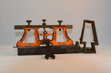 Kiewa Valley Historical Society
Sharpener Saw Raker/Jointer, early 1900s
This raker/jointer/guage set is a sharpening tool for cross cut logging saws. The logging saws used in the early 1900's for the clearing of forests required constant sharpening of their "cutting teeth". The logging of forested areas during these times was very much a "hands on" method of either one or two men by the use of saw or hand axe. Chain saws, chain and ball(clearing) and bulldozing methods came in the mid 1900's.This particular saw sharpening method was used by surveyors laying down boundaries for the S.E.C. Victoria Hydro Electricity Scheme (1920's). This item was given to a local Kiewa Valley lad who accompanied the initial surveyors. The lad was responsible for the tendering and feeding of the surveyors "pack horses". Surveys during this period and in the dense mountainous terrain of the Victorian Alps was both exhausting and hazardous. Overnight accommodation at various log cabins was not always possible and swag/tent alternative was the "fall back" This raker/jointer saw sharpener was made in the USA (DISSTON) from cast and flat iron. The main body has been painted in orange. It has three adjustment screws on the top horizontal bar and one bolt on(adjusting) leveling platform on the bottom. The small size and weight of this saw sharpener was ideal for the travelling/mobile logger or surveyor(as in this case). The main frame resembles two towers connected by two horizontal bars and the top of the towers has a horizontal bar with adjustment screws. See KVHS 0090 (B) for setting stake wedge adjusting the rake and cutting angle and KVHS 0090 (C) for a small spanner (for adjustments).On one inner supports is stamped "DISSTON" and on the other "U.S.A."hand tool, saw, sharpening method, tree felling. -
 Federation University Historical Collection
Book, Railway Practice: a collection of working plans and practical details of construction in the public works of the most celebrated engineers, 1847 (exact)
A green cloth hard cover book. Title and author's name are engraved in gold on spine. This is the 3rd edition, first series with black and white illustrations. It describes the engineering practices of the early days of British railroads. The book includes (series 1 to 4)and it contains, roads, tramroads and railroads, bridges, aqueducts, viaducts, wharfs, warehouses, roofs, and sheds, canals, locks, sluices, & the various works on rivers, streams, etc., harbours, docks, piers and jetties, tunnels, cuttings and embankments, the several works connected with the drainage of marshes, marine sands, and the irrigation of land, water-works, gas-works, water-wheels, mills, engines.civil engineering, railway practice, rail constructions, s c brees, western railway great britain, public works, railroads, canals, s.c. brees, samuel brees, samuel charles brees -
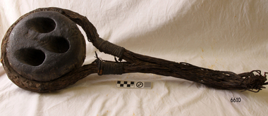 Flagstaff Hill Maritime Museum and Village
Deadeye, circa 1873
This example of a sailing ship’s ‘dead-eye’ is from the wreck of the LOCH ARD, which sank near Port Campbell in 1878. The vessel was an iron hulled clipper ship constructed for the Loch Line in 1873. It was part of a fleet of similar merchant ships owned by that company, which specialised in bringing passengers and goods from London via the Great Circle route to Melbourne, and returning to Britain via Cape Horn with the colony’s wool clip. Deadeyes were a common feature of sailing ship technology in the nineteenth century. They were a simple, cheap, and hard-wearing device that, in conjunction with another deadeye, provided an effective means of levering, or tightening, attached ropes and stays. Lower deadeyes were fixed to the sides of the ship by an encircling metal collar (inset in a flattish groove chiselled around the outer circumference of the disc), which was bolted to iron bars attached to the hull (called chain-plates). Upper deadeyes were looped by a strong hemp or wire rope (inset in a rounded groove carved around the outer circumference of the disc), which was joined to the bottom ends of the rigging which reached up to secure the masts into position (called shrouds or stays). Connecting a Lower deadeye to its corresponding Upper deadeye was a rope (called a lanyard) which looped up and down through the three “eyes” of each disc, to form a pulley system. The hitching of the two deadeyes with a looped lanyard provided the means of tightening, or loosening, the tension on the mast rigging ― essentially by pulling against the chain-plates bolted to the outside of the hull. It was a procedure that could be performed by sailors at sea and in emergencies. For example, after a gale the stays may have stretched and the masts worked loose, requiring retightening. Or, in the extreme circumstance of shipwreck, the lanyards might need to be released on the weather side, so that the masts fall away from the stricken vessel. The shipwreck of the LOCH ARD is of State significance. Victorian Heritage Register S417.A well-preserved ship’s deadeye with wire loop rope still attached. The original tar coating for water-proofing still remains, colouring the entire artefact black. It is wrapped in hessian cloth and hemp cord and is currently in storage under secure and stable conditions. This deadeye was recovered from the wreck of the LOCH ARD. The artefact is a typical deadeye, comprising a thick round wooden disc, pierced by 3 similarly sized and shaped holes from one flat side through to the other, in a triangle formation. The survival of the wire cable loop-rope suggests it was an Upper Deadeye, connected to the shrouds (mast rigging). Previous number PWO 2388.flagstaff hill, warrnambool, shipwrecked-coast, flagstaff-hill, flagstaff-hill-maritime-museum, maritime-museum, shipwreck-coast, flagstaff-hill-maritime-village, deadeye, loch ard, rigging