Showing 940 items
matching construction works
-
 Eltham District Historical Society Inc
Negative - Photograph, J.A. McDonald, Sherbourne Road, Montmorency, c. July 1962
... Reconstruction works Road construction shire of eltham Medium format 120 ...View looking west across Sherbourne Road to intersection of Rattray Road from present-day forecourt entrance to 7-Eleven Eltham service station The BP Service Station is now an Ampol Service Station (2022) Google Street View Apr.. 2022 https://goo.gl/maps/LM4APKCwj1ohBDPv5Record of various Shire of Eltham infrastructure works undertaken during the period of 1952-1962 involving bridge and road reconstruction projects, sometimes with Eltham Shire Council Project Reference numbers quoted. It was during this period that a number of significant improvements were made to roads and new bridges constructed within the shire that remain in place as of present day (2022). In many situations, the photos provide a tangible visible record of infrastructure that existed throughout the early days of the Shire. The album was put together by or under the direction of the Shire Engineer, J.A. McDonald.1962-07, ampol service station, bp service station, montmorency, rattray road, service station, sherbourne road, infrastructure, reconstruction works, road construction, shire of eltham -
 Eltham District Historical Society Inc
Album - Photograph Album, Alan Gardiner, M.M.B.W Braeside Sewage Treatment Plant Construction, 1939
In April 1928 the MMBW had the land and the plans for what they were to construct but the timing of the actual building did not proceed as planned. Before the construction could commence the Great Depression of the 1930s intervened forcing the shelving of its plans. The new owners then offered the land for lease resulting in Frederick Werrett taking the opportunity to take up the land he formerly owned to continue his market gardening activities of growing potatoes, onions and other crops. The land and improvements made by Syme were leased in 1929 to Harry Telford a trainer from New South Wales. Phar Lap grazed there for a short time. [9] However the population of Melbourne continued to grow and the need for a sewerage treatment plant did not go away. In 1939 when the effects of the Depression had dissipated work on the Sewerage Effluent Treatment Plant commenced and the following year in October the Premier of the State, Albert Dunstan, officially commissioned it. The Sewerage Effluent Treatment Plant at Braeside served the communities of south-east Melbourne for thirty five years until 1975. In that year all the sewers that entered the Braeside plant were diverted to the South Eastern Trunk Sewer complex at Carrum.[10] In 1982 the chairman of the MMBW at that time, Alan Croxford, announced that a substantial part of the property at Braeside would be administered by the Parks and Gardens section of MMBW as a public park. Subsequently the responsibilities were transferred to Parks Victoria, the situation that exists today. It is known as “Braeside Park” now. [Source: Sewerage Treatment Plant at Braeside, Kingston Local History, https://localhistory.kingston.vic.gov.au/articles/407]alan gardiner collection, 1939, braeside sewage treatment plant, construction, melbourne metropolitan board of works, mmbw -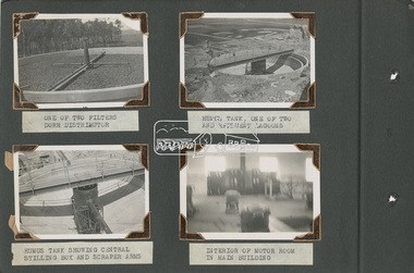
 Eltham District Historical Society Inc
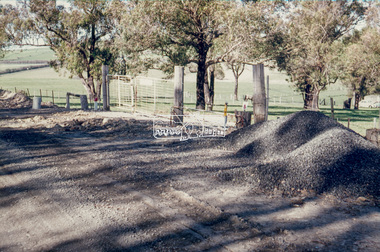
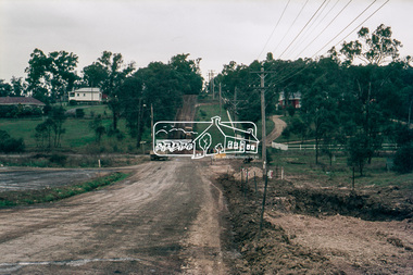
Slide - Photograph, Eltham Shire Council, Unidentified road; Infrastructure works, roads, footpaths and drainage, Shire of Eltham, c.1972
35mm colour positive transparency blue Agfacolour Service plastic mount1972, footpaths and gutters, infrastructure, road construction, road drainage, roadworks, shire of eltham, unidentified -
 Eltham District Historical Society Inc
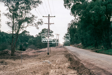
Slide - Photograph, Eltham Shire Council, Unidentified road, possibly Kangaroo Ground; Infrastructure works, roads, footpaths and drainage, Shire of Eltham, c.1972
35mm colour positive transparency blue Agfacolour Service plastic mount1972, footpaths and gutters, infrastructure, road construction, road drainage, roadworks, shire of eltham, unidentified, kangaroo ground -
 Eltham District Historical Society Inc
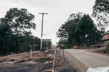
Slide - Photograph, Eltham Shire Council, Unidentified road, possibly Kangaroo Ground; Infrastructure works, roads, footpaths and drainage, Shire of Eltham, c.1972
35mm colour positive transparency blue Agfacolour Service plastic mount1972, footpaths and gutters, infrastructure, road construction, road drainage, roadworks, shire of eltham, unidentified, kangaroo ground -
 Eltham District Historical Society Inc
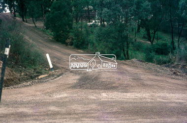
Slide - Photograph, Eltham Shire Council, Unidentified road; Infrastructure works, roads, footpaths and drainage, Shire of Eltham, c.1972
35mm colour positive transparency blue Agfacolour Service plastic mount1972, footpaths and gutters, infrastructure, road construction, road drainage, roadworks, shire of eltham, unidentified -
 Eltham District Historical Society Inc
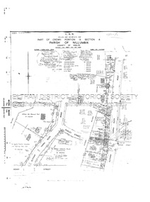
Document - Survey Plan, Country Roads Board, SP 6801, Eltham-Yarra Glen Road; Brougham St to Bridge St, 1958
1958 C.R.B. Plan of Survey of Part of Crown Portion 12 Section 4 Parish of Nillumbik, County of Evelyn Eltham-Yarra Glen Road, Shire of Eltham Shows Surveyor field notes, property ownership and building type and construction.a.j. collis, a.s. & c.g.h. fitzpatrick, board of land & works, bridge street, brougham steet, commonwealth bank of australia, country roads board, eltham, eltham rsl sub-branch, f.h. collis, f.m. smith, f.n. & e.j. burgoyne, franklin street, h.c. & r.e. burgoyne, j. jorgenson, j.f. & j.e. morris, j.n. & h.c. burgoyne, j.s. blow, john street, main road, p.e. smith, pitt street, r.j. dripps, s.j. taylor, survey plan, trustees of the eltham methodist church, 1958, eltham-yarra glen road, neil webster collection -
 Eltham District Historical Society Inc
Document - Survey Plan, Country Roads Board, SP 6313, Eltham-Yarra Glen Road; Luck St to Henry St, 1956
1956 C.R.B. Plan of Survey of Part of Crown Portion 13 Section 4 Parish of Nillumbik, County of Evelyn Eltham-Yarra Glen Road, Shire of Eltham Shows Surveyor field notes, property ownership and building type and construction.eltham-yarra glen road, country roads board, eltham, main road, survey plan, 1956, a.l. lyon, a.w. brinkkotter, arthur street, c.r. burkett, dudley street, e.n. staff, eltham war memorial trust, henry street, luck street, pryor street, the board of land & works, the equity trustees executors and agency coy ltd, the roman catholic trusts corporation, victorian railways commision, neil webster collection -
 Eltham District Historical Society Inc
Document - Survey Plan, Country Roads Board, SP 6559-6560, Eltham-Yarra Glen Road; Elsa Ct to Luck St, 1957
1957 C.R.B. Plan of Survey of Part of Crown Portion 13 Section 4 and Crown Allotment 1 Section 1 Parish of Nillumbik, County of Evelyn Eltham-Yarra Glen Road, Shire of Eltham Shows Surveyor field notes, property ownership and building type and construction.eltham-yarra glen road, country roads board, eltham, main road, survey plan, 1957, a.m. & a.a. iowerson, a.mcg. hepburn, cecil street, coffee lounge, diamond street, e.g. murrell, elsa court, h.b. woodhead, j.c. & s.i. harding, la ronde, luck street, r.m. & v.m. white, r.n. mowatt, the board of land & works, w.g. hains, neil webster collection -
 Eltham District Historical Society Inc
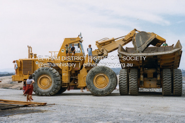
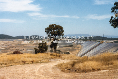
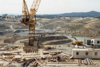
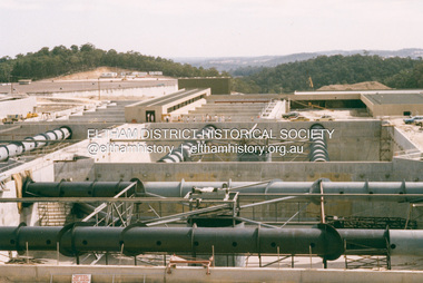
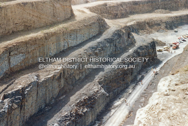
Photograph - Colour Print, Lewis Tulk, Construction Winneke Reservoir and treatment plant / Melbourne and Metropolitan Board of Works, c.1981
Sugarloaf Reservoir is situated on former farmland. This large water storage was completed in 1982 and serves Melbourne's northern suburbs. Within the visitor areas are two picnic grounds and other recreational facilities. Below its massive rock embankment is located the Winnecke Treatment Plan designed to purify its water before being piped into Melbourne. The dam partly inundated the old firing ranges of the former Christmas Hills Rifle Club. Source: Christmas Hills Now and then: Yarra Glen & District Historical Society, 2004.lewis tulk collection, construction, sugarloaf reservoir, winnecke dam -
 Eltham District Historical Society Inc
Photograph, Doug Orford, Eltham Courthouse, 730 Main Road, Eltham, 1985, 1985
This building is a fine example of a very early small brick country court house which retains its furnishings and has important associations with the early history of the Eltham township. It was used for Eltham Road Board meetings in the 1860s and later to provide additional school accommodation. It is the oldest public building remaining in Eltham and forms an important group in historic and streetscape terms with the adjoining former police residence. The survival of the furnishings (of unknown origins) is of particular significance given the building's age. This building, and the former police residence beside it, were constructed as a result of a petition by five Eltham residents in 1857. The nearest police were at Heidelberg eight miles away or at the Caledonia Diggings 21 miles away. After the construction of the Court of Petty Sessions at Eltham in 1859-60 (which was designed by the Public Works Department and built by a Mr Duncan for a cost of 536 pounds), it was used for a variety of purposes. Eltham Road Board meetings were held there until 1868 when the board was transferred to Kangaroo Ground and as the Road Board Secretary's office, until this was transferred to Wingrove Cottage in 1867. It was used as an overflow for the Dalton Street School in 1875. According to National Trust records, the Eltham Court House is a relatively rare building type. There are only six other known examples of similar small brick country court houses in the state which have small projecting entry porches and a gabled form. Roll of 35mm colour negative film, 7 stripsFuji 100Neltham, eltham courthouse, main road -
 Eltham District Historical Society Inc
Negative - Photograph, Main Road, Eltham, c.Dec. 1983
Road sign advising of proposed reconstruction works of Main Road to install a roundabout at Mount Pleasant Road. Traffic to Lower Plenty and Templestowe to be diverted down Bridge Street (and Bolton Street) effective January 1984. The proposed roundabout did not proceed. Instead traffic islands on Mount Pleasant Road were installed in place of temporary blocked out islands.Film - Kodak CM 400 5079 7 strips, 26 framesinfrastructure, roads, road construction, roundabout, road sign, main road, mount pleasant road -
 Eltham District Historical Society Inc
Photograph, Kerb and channeling works, Beard Street and Main Road, Eltham, 3 Sep 1981
Roll of film taken by Eltham Shire Council officers of roads and houses in the Eltham East area, 3 September 1981 prior to construction of new water main; including views of existing damage to footpaths and gutters and general views of Beard Street. These images provide a perspective of housing estate developments and changes in housing styles and road development which began sweeping in from the mid 1970s with increasing urbanisation of what was once more outlying suburbs and regions.35mm colour positive transparency (1 of 28) Mount - Kodak Kodachrome Cardbeard street, eltham, footpaths and gutters, infrastructure, roads, main road -
 Eltham District Historical Society Inc
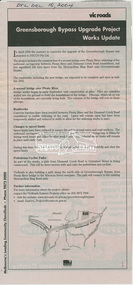
News Clipping, Advertisiing; Greensborough Bypass Upgrade Project Works Update, VicRoads, Diamond Valley Leader, 15 December 2004, 2004
Addition of second stage bridge over Plenty River and extension of ring road connectionNewsprintgreensborough bypass, road construction, vicroads -
 Eltham District Historical Society Inc
Article - Newspaper Clipping, Diamond Valley Leader, Advertisement: Greensborough Bypass Upgrade, Works Update; Vic Roads, Diamond Valley Leader, 15 June 2005, p24, 15/06/2005
Public advice regarding works undertaken for the Greensborough ByPassNewspaper clipping bridge construction, greensborough bypass, road construction -
 Eltham District Historical Society Inc
Photograph, Peter Pidgeon, Birch Cottage, Eltham-Yarra Glen Road, Christmas Hills, 27 September 2018, 2018
Originally built by John Hill, a shoemaker at Kangaroo Ground around 1878. In the late 1970s when our Society was the Shire of Eltham Historical Society, an offer was made to the Society regarding use of an old cottage at Christmas Hills. The cottage sat beside Watsons Creek just outside the then Shire of Eltham but following municipal restructuring it now lies within the Shire of Nillumbik. For various reasons the offer ultimately lapsed. At that time some research on the cottage was carried out for the Society by Keith Chappel as part of a larger research project that he was doing. Keith’s notes were taken from Lands Department records and showed that the property was the subject of a permissive occupancy of Crown land comprising the creek reserve. In 1903 a Miner’s Right of one acre in area was granted to Edwin Samuel Birch. In 1907 Birch applied to purchase this land but was unable to because it was part of the creek reserve. The documents show that the cottage existed at that time. Upon Birch’s death in 1932, his daughter, Honor Mary Birch was granted a permit to occupy the residence. Honor Mary Birch, known as Nora, was born 1900, the daughter of Edwin Samuel Birch and Honor (nee Young). In 1939 she married George Henry Williams (aka Henry). Honor died 8 July 1976. Her siblings were Margaret Martin (dec), Bert Birch and Brigidene Brinkkotter. In her will she gave and bequeathed “all the improvements on the land held by me at Christmas Hills under Permissive Occupancy from the Department of Land and Survey consisting of the house property thereon and all the contents of the said house to my nephew Brian Joseph Martin of Christmas Hills aforesaid farmer”. The will described the property as a four room, five square house, about 100 years old with enclosed verandah, including kitchen, combined lounge dining room, bedroom and store room; built of ‘bush slabs’ with a corrugated iron roof. A dairy had been erected in 1935. After her death, the property was acquired by the Melbourne Metropolitan Board of Works in 1978. The property is listed on the Victorian Heritage Database HO200-Hill, later Birch farm complex, 945 Eltham-Yarra Glen Road, Watsons Creek and described as: The house has a steep but simply gabled roof form clad with corrugated iron, vertical adzed hardwood slab front wall construction, split palings to the gable ends; rubble freestone chimney at one end (with added gsi flue), pole-framed Graeme Butler & Associates, 2006: 101 Shire of Nillurnbik Planning Scheme Amendment C13 Heritage Assessments verandah (rebuilt?); six-pane double-hung sash windows; T&G bead-edge boarded ledged & braced door; and paling clad rooms added at verandah ends. A slab-clad large fireplace is at the north corner of the house, with a gsi upper cladding added and an internal lining of rubble stone. The rear facade is different construction, being drop-slab, and sits beneath a rear skillion addition to the main gabled form: this may be more recent construction. The house appears to have been once set up for public display and may have been recreated in part for that purpose. Outbuildings are reached by a track along the east side of the house, including what may have been a creamery (typical standard inter-war design clad with corrugated iron and lined with 1938 Lysaght Queens Head Australia galvanised sheet iron) and a paling clad gabled out-house. Timber outbuildings of differing eras are to the north-west of the house, with pole framing and paling infill construction and Redcliffe brand corrugated iron. Post and rail (front) and split paling (rear) fence remnants line the front boundary. Pepper trees part of house yard landscape49 born digital images (includes one panoramic stitch and nine frames from drone video)birch cottage, christmas hills, early settlers, edwin samuel birch, honor mary birch, john hill, watsons creek -
 Eltham District Historical Society Inc
Slide, Possibly looking east along Rosehill Road, Lower Plenty towards Bolton Street intersection, 18 July 1972, 1972
Reconstruction works by Eltham Shire Council, Bolton Street, Eltham, 18 July 197235 mm colour positive transparency Mount - Agfacolor Service (Blue)bolton steet, eltham, eltham shire council, infrastructure, lower plenty, road construction, rosehill road -
 Eltham District Historical Society Inc
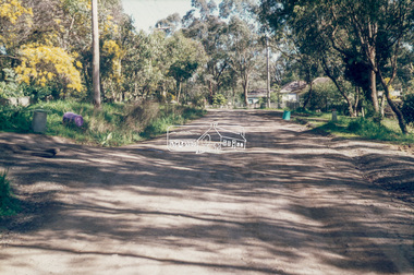
Slide, Looking south along Bolton Street towards intersection with Rosehill Road, Lower Plenty, 18 July 1972, 1972
Reconstruction works by Eltham Shire Council, Bolton Street, Eltham, 18 July 197235 mm colour positive transparency Mount - Agfacolor Service (Blue)bolton steet, eltham, eltham shire council, infrastructure, lower plenty, road construction, rosehill road -
 Eltham District Historical Society Inc
Slide, Drainage under driveway near No. 10 Bolton Street, Lower Plenty, 18 July 1972, 1972
Reconstruction works by Eltham Shire Council, Bolton Street, Eltham, 18 July 197235 mm colour positive transparency Mount - Agfacolor Service (Blue)bolton steet, eltham, eltham shire council, infrastructure, lower plenty, road construction, rosehill road -
 Eltham District Historical Society Inc
Slide, Looking south along Bolton Street to intersection with Main Road, 18 July 1972, 1972
Reconstruction works by Eltham Shire Council, Bolton Street, Eltham, 18 July 197235 mm colour positive transparency Mount - Agfacolor Service (Blue)bolton steet, bolton street shops, eltham, eltham shire council, infrastructure, main road, road construction -
 Eltham District Historical Society Inc
Slide, Looking north along Bolton Street towards intersection with Baxter Street, Eltham, 18 July 1972, 1972
Reconstruction works by Eltham Shire Council, Bolton Street, Eltham, 18 July 197235 mm colour positive transparency Mount - Agfacolor Service (Blue)baxter street, bolton steet, bolton street shops, eltham, eltham shire council, infrastructure, main road, road construction -
 Eltham District Historical Society Inc
Slide, Looking north along Bolton Street at intersection with Baxter Street, Eltham, 18 July 1972, 1972
Reconstruction works by Eltham Shire Council, Bolton Street, Eltham, 18 July 1972 No. 154 Bolton Street on right35 mm colour positive transparency Mount - Agfacolor Service (Blue)baxter street, bolton steet, bolton street shops, eltham, eltham shire council, infrastructure, main road, road construction -
 Eltham District Historical Society Inc
Slide, Looking east up Baxter Street from Bolton Street, Eltham, 18 July 1972, 1972
Reconstruction works by Eltham Shire Council, Bolton Street, Eltham, 18 July 1972 35 mm colour positive transparency Mount - Agfacolor Service (Blue)baxter street, bolton steet, bolton street shops, eltham, eltham shire council, infrastructure, main road, road construction