Showing 787 items matching "crop"
-
 Flagstaff Hill Maritime Museum and Village
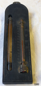
Thermometer, Early 20th Century
A Storm Glass and Thermometer such as this one would be used in predicting or forecasting the weather. Farmers used predictions they read from their Storm Glass to prepare for stormy weather or for choosing a good time for planting or harvesting their crops. This could mean to them the difference between a good year and a year without income. This design has been in use since the early 1800’s. According to Admiral Fitzroy (who studied the storm glass and wrote instructions on its use) the liquid in the glass changes composition and appearance according to the direction of the air moving around it. He advised the user to disturb the contents once or twice a year by tipping it upside down and shaking it gently. Item is a good example of a barometer/thermometer that would have been in most homes and farms from the late 19th century and early 20th century. This item would have been massed produced at the time therefore easily available and quite cheap to purchase making this particular item not very significant as not associated with a historic person or property or with a known manufacturer or date.Storm Glass and Thermometer, commonly called a 'Cottage Barometer', mounted on a rectangular dark rectangle of wood, top corners rounded. The Storm Glass (or weather glass, or chemical weather glass) is suspended in a long oval shaped hole in the wood on left side, held in place at top and at bottom with 2 metal bands secured by nails. The glass of this gauge is hand blown, sealed at the top with another layer of glass. The watery fluid in the storm glass is opaque brownish colour with dark particles floating in it. (Storm glasses were usually filled with a variation of a mix of camphor, distilled water, ethyl alcohol and silver nitrate.) The alcohol thermometer is mounted on the right side of the wood, bulb resting in a hollow, attached at top and near base by 2 thin metal strips, with clover-leaf shaped ends, nailed into place. Over the bulb is nailed a metal guard with 3 ventilation slits cut into it. On left of thermometer is a scale, stamped into wood, 30 below zero to 130 above zero, in 2 degree intervals. A border of 2 thin parallel lines, with remnants of light coloured paint, is around the block of wood. On the reverse side, a metal plate is nailed to the top with a mounting hole in it. Impressed sideways along edge of barometer is "STORMY" "CHANGE" "FAIR". Across the top of the thermometer is a fleur de leis in the wood, and above this it is stamped "FAHRENHEIT". On right of the thermometer, stamped into the wood, is "BLOOD/HEAT", "SUMR/HEAT", "TEMPE/RATE", "FREEZ/ING". On the back of the wood, at the base, are remnants of a white sticker with "...111.73". Carved into the wood is "HOLLAND / AV". flagstaff hill, warrnambool, shipwrecked coast, flagstaff hill maritime museum, maritime museum, shipwreck coast, flagstaff hill maritime village, great ocean road, barometer, cottage barometer, storm glass, thermometer, chemical weather glass -
 Otway Districts Historical Society
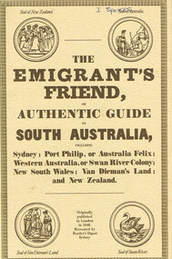
Book, Reader's Digest Services Pty Limited, The emigrant's friend, or authentic guide to South Australia, 1974
This book is a replica of a booklet printed in the United Kingdom. In 1848, when it was published in London as a guide to prospective emigrants, 23,904 people left the United Kingdom for the Australian colonies and New Zealand. In 1847, with the failure of potato crops threatening famine in Ireland and growing political unrest at home, the British Government had once again encouraged emigration by offering free passage to candidates of 'good character'. Immigration, particularly by the labouring classes, was intended to relieve both the overburdened Mother Country and the colonies which had acute labour shortages. The booklet gives some history of each colony as well as the sale of lands, mines and mining, produce, the price of living, wages and, generally, the situation. The emigrant's friend, or authentic guide to South Australia including Sydney: Port Phillip, or Australia Felix: Western Australia, or Swan River Colony: New South Wales: Van Dieman's Land: and New Zealand. Reprint. Reader's Digest Services Pty Limited; Surrey Hills (NSW); 1974. 40 p. Soft cover. australia; colonies; settlement; nsw; port phillip; western australia; south australia; van dieman's land; new zealand; emigration; immigration; -
 Wodonga & District Historical Society Inc
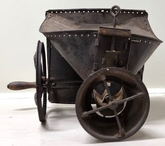
Functional object - Hand operated seed broadcaster
Seed broadcaster were used to distribute seed across a small area or to fill in patches where seeding has been missed. This method does not ensure a uniform distribution of seeds unless the person using the machine walks at a very measured pace. It also requires a lot of time and manual labour if used in larger areas. It was most used for planting cover crops, grains, grasses and similar plants that do not need to be in neat rows. The hand-crank broadcast seed spreader was invented in 1868 by Samuel S. Speicher (aka. Spyker) in Indiana, USA. By 1955 new developments included the invention of a seed broadcaster on wheels and these smaller spreaders started to disappear.This item is representative of agricultural machinery used on a local, national and international level in the late 19th and early 20th century.A metal hand seed broadcaster. A hopper at the top was the receptacle for seed. The wheel with a handle on the side when turned drives the cogs attached to an axle. This action rotates the attached spindle with blades to propel seed out the front of the broadcaster. The broadcaster would have had a shoulder strap and a bag of seed would have been added to the hopper and secured with twine through the holes around the top.agricultural tools, farm machinery -
 Ballarat Tramway Museum
Photograph - Black & White Photograph/s, Sutcliffe Pty Ltd, c1931
Black and white photograph of W3 655 - 3/4 side on view - background has been taken out. Tram fitted with windshield instead of driver's doors on both sides of drivers cabin but no route number boxes. Showing "SPECIAL". Probably taken soon after built in 1931. Photo taken by Sutcliffe Pty Ltd. Photo has "Sutcliffe PHONE MELBOURNE" embossed into the photograph in the bottom right hand corner.On rear in pencil "W3 wide entrance 33" wheel with motor car springing", "Change Transportation wed A.M.", "return to Shennan" with arrow pointing to "Gordon & Gotch (Aus/Asia) Ltd Sydney" and an arrow between cropping marks with notation "6" wide between marks only" and "1HT D/E 120s/c D/E as layout attached" - indicating used in a printed paper or magazine.trams, tramways, mmtb, w3 class, tram 655 -
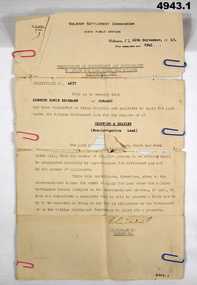 Bendigo Military Museum
Certificate, Certificate of eligibility and suitability for soldier settlement
1. Foolscap size sheet (see condition) Letterhead is for the soldier Settlement Commission. State Public Offices. Tel F 0234. Dated Melb 16 Sep 1947. Letter No 8945. In the text is Cert No. 4677 for Kenneth Edwin Beckman of Cowangi. The purpose of the land is for cropping and grazing (non irrigation land) 2. Letter quarto size paper. Letterhead of Australian Mil Forces. Tel No. M 45966 Ext 30. Victoria Echelon and records 291 Lonsdale St Melbourne dated 2 Nov 1945. In the text is printed EX V64354 K E Beckman. Cert of Discharge 294425. RAS Badge No. A 99448. Will (AAF A.131) One..admin record, ww2 -
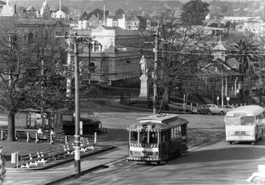 Ballarat Tramway Museum
Photograph - Black & White Photograph/s, The Courier Ballarat, Jul. 1971
Yields information about the place - Tramway Centre or City Centre - with trams prior to closure and their bus replacement, how they fitted with their streetscape.Black and White copy photograph of a newspaper photograph taken by The Courier - published - 28/7/1971 of No. 12 & bus at Sturt & Lydiard St corner, showing the approaching end of the tramway era. Follows the first route conversion. Photo taken from the Town Hall, of the intersection of Sturt and Lydiard Streets, with statute of Robert Burns, Titanic Bandstand, Post Office and other buildings in the photograph. See Reg Item 2182 for the Courier Newspaper clipping - heavily cropped. Collected by Alan Bradley from the Ballarat Courier early 1980's. See Excel file "Record of Ballarat Courier Photos SEC era" (Archive Documents) for source of details.On rear stamped "Copyright, The Ballarat Courier Proprietary Limited."tramways, trams, sturt st, tramway centre, bus replacement, robert burns, statues, tram 12 -
 University of Melbourne, Burnley Campus Archives
Film - Black and white 16mm film reels, Publicity Branch Victorian Department of Agriculture, Shell Film Unit, Commonwealth of Australia, Department of Information, Department of Agriculture Film Reels, 1945-1960
13 X 16mm film reels. * Publicity Department, Department of Agriculture. # State Film Centre.(1) Not labelled. (2) "Canning the Victory Crop"*#. (3) Freezing. Fruits and Vegetables" #. (4) "Don't be a Carrier" *. (5) "Mineral Defficiencies BI" Wool Board Production *. (6) "Apple Aphis" Shell Film Unit 3.1.55. (7) "A.I.F. Magazine No.2." "PRAC" Commonwealth of Australia Department of Information Film #. (8) "Greenhouse White Fly" "Scottish Sha?" #. (9) "Fruit Tree Pruning July.2.1960" # (10) "Brussels Sprouts" *#. (11) "Codling Moth" Shell Film Unit 3.1.55.# (12) "Report on Molybdenum" *#. (13) "Operation Grasshopper" *# publicity department, department of agriculture victoria, state film centre, crops, freezing, fruits, vegetables, mineral defficiencies, wool board production, apples, aphis, greenhouses white fly, fruit trees, pruning, brussels sprouts, grasshopper -
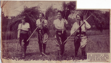 University of Melbourne, Burnley Campus Archives
Newspaper - Newspaper Cutting, The Herald, Making Girl Gardeners, 1931
Newspaper cuttings of an article and accompanying photo in "The Herald" December 9, 1931. The photo is of four students carrying pitchforks of oats, with the caption: "Girl harvesters at Burnley Horticultural School see plenty of the practical side of farming. They are carrying the last sheaves of an oats crop stacked yesterday." The accompanying article, "Burnley's Long Career," describes the students activities and the history of the school. It discusses the changes in the girls' uniforms over the years and the types of girls who take the course: those wanting a career as gardeners, those wishing to make 'pin money' from part-time gardening and those who regard gardening as a domestic hobby. Research and writing are also mentioned as potential careers.the herald, students, burnley horticultural college, students working outside, oats, careers, uniforms -
 Eltham District Historical Society Inc
Photograph, From left: Unknown, Mario Fabbro and possibly Helen Skipper, Bell Street, Eltham
At Bell Street, Fabbro Farm, Eltham; From left: Unknown, Mario Fabbro and possibly Helen Skipper, standing in the middle of a vegetable crop. The site of the Fabbro farm (Diamond Creek side land) is now called Barrack Bushlands. It is doubtful that Fabbro's farm holding was ever called Barrak Park, This title is fairly recent after the Shire of Eltham purchased the land, including the last section in 1993/94. About this time the area on the west side of Falkiner Street was purchased by a private developer and developed as housing. The area in Bell Street opposite the Eltham High School was purchased by the State Government is recent years and is called Fabbro Fields. The Fabbro Family operated their farm in Bell Street, Eltham. 1 black and white photographfabbro's farm, bell street, eltham, maurice fabbro, farming, helen skipper, vegetables -
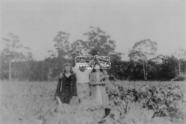
 Eltham District Historical Society Inc
Photograph, Fabbro's farm, Bell Street, Eltham, c.1990s
Fabbro's farm and house, Bell Street, Eltham, c.1990s. A crop of artichokes were planted on the farm at this time. The site of the Fabbro farm (Diamond Creek side land) is now called Barrack Bushlands. It is doubtful that Fabbro's farm holding was ever called Barrak Park, This title is fairly recent after the Shire of Eltham purchased the land, including the last section in 1993/94. About this time the area on the west side of Falkiner Street was purchased by a private developer and developed as housing. The area in Bell Street opposite the Eltham High School was purchased by the State Government is recent years and is called Fabbro Fields. The Fabbro Family operated their farm in Bell Street, Eltham. 1 colour photograph printed with white borderfabbro's farm, bell street, eltham, artichokes, barak farm -
 Eltham District Historical Society Inc
Photograph, Artichokes growing at Bell Street, Eltham, c.1990s
Fabbro's farm and house, Bell Street, Eltham, c.1990s. A crop of artichokes were planted on the farm at this time. The site of the Fabbro farm (Diamond Creek side land) is now called Barrack Bushlands. It is doubtful that Fabbro's farm holding was ever called Barrak Park, This title is fairly recent after the Shire of Eltham purchased the land, including the last section in 1993/94. About this time the area on the west side of Falkiner Street was purchased by a private developer and developed as housing. The area in Bell Street opposite the Eltham High School was purchased by the State Government is recent years and is called Fabbro Fields. The Fabbro Family operated their farm in Bell Street, Eltham. 1 colour photograph printed with white borderfabbro's farm, bell street, eltham, artichokes, barak farm -
 Eltham District Historical Society Inc
Photograph, Maurice Fabbro with artichokes growing at Bell Street, Eltham, c.1990s. Maurie is in his 70s
Fabbro's farm and house, Bell Street, Eltham, c.1990s. A crop of artichokes were planted on the farm at this time. The site of the Fabbro farm (Diamond Creek side land) is now called Barrack Bushlands. It is doubtful that Fabbro's farm holding was ever called Barrak Park, This title is fairly recent after the Shire of Eltham purchased the land, including the last section in 1993/94. About this time the area on the west side of Falkiner Street was purchased by a private developer and developed as housing. The area in Bell Street opposite the Eltham High School was purchased by the State Government is recent years and is called Fabbro Fields. The Fabbro Family operated their farm in Bell Street, Eltham. 1 colour photograph printed with white borderfabbro's farm, bell street, eltham, artichokes, barak farm, maurice fabbro -
 Kew Historical Society Inc
Photograph, Wade's Farm, Kilby Road, Nineteenth Century
""The public trial of reaping machines, under the auspices of the Port Phillip Farmers' Society, advertised to take place on Friday, last, but postponed on account of the weather, came off December 27. The place selected (Mr. Wade's farm, Belford, near Kew) is undulating ground, with a remarkably heavy crop of wheat upon it. This, taken in connection with, the state of the ground, still soft from the recent rains, made the trial an uncommonly severe one. ..."(South Australian Advertiser, 15 January 1859) Some bricks used in Kew buildings came from the brickworks on Wade's Farm at the end of Belford Road near the Yarra River (now part of the Kew Golf Club). (History of RSL by John Torpey)Wade's Farm, Kilby Road, Kew.wade's farm, farming (kew), kilby road, north kew, belford road, kew, kew golf club -
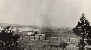
 Ringwood and District Historical Society
Negative, Photographic negatives from Archie and Ruby Harker Collection - Early 1950's to Mid 1960's, B&W and Colour
Archir Harker was married to Ruby Wilson and mentioned in the "Wielands of Heathmont "book. From Greg Coker: In August 2023, RDHS asked Greg Coker to scan a set of negatives. He was able to work out, through various notes, that the pictures were taken by J A Harker of 9 Grange St, Mont Albert in the mid 50s to the mid 60s. Most of the film was 9cm X 6cm B&W negatives. All pictures have been cropped and where appropriate, put through a light filter. They have been scanned at 1600ppi resulting in ~3meg B&W shots (~5meg for the half dozen colour shots). The Harkers certainly liked their hiking – they were ahead of their time. Images scanned from Kodakl packet of negatives, undated. After scanning in 2023 by Greg Coker, the negatives and packet were. Some photos may be duplicated in other VC Harker/Weiland family records if the original prints were donated. Greg's comments: Early 50s to Mid 60s – Original colour & B&W negatives Largest packet of negatives with multiple sets clearly combined in this one envelop These were made up of: - 8 colour 9X6cm negatives – late 60s - ~40 B&W 9X6cm negatives – Early - late 50s - 3 large B&W 12x9cm negatives – Mid 50s Most of the pictures in this set are portraits pictures of Mr or Mrs Harker. Many in the front and back yards of 9 Grange street, Mont Albert. A few negatives of Phillip Island here also (Identified the Nobbies). Kodacolor Prints. -
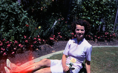
 Ringwood and District Historical Society
Negative, Photographic negatives from Archie and Ruby Harker Collection - Early 1960's Seaside holiday and mountain views
Archir Harker was married to Ruby Wilson and mentioned in the "Wielands of Heathmont "book. From Greg Coker: In August 2023, RDHS asked Greg Coker to scan a set of negatives. He was able to work out, through various notes, that the pictures were taken by J A Harker of 9 Grange St, Mont Albert in the mid 50s to the mid 60s. Most of the film was 9cm X 6cm B&W negatives. All pictures have been cropped and where appropriate, put through a light filter. They have been scanned at 1600ppi resulting in ~3meg B&W shots (~5meg for the half dozen colour shots). The Harkers certainly liked their hiking – they were ahead of their time. Images scanned from R&K Developing and Printing Services packet of negatives, undated. After scanning in 2023 by Greg Coker, the negatives were disposed and just the packet retained. Some photos may be duplicated in other VC Harker/Weiland family records if the original prints were donated. Greg's comments: Early 60s – Original Negatives. Sea side holiday and valley views The date is best guess. Mrs Harker looks around the same age as the 1958 set. There is a prominent lighthouse in shot – that may help identify where the holiday was. I suspect the valley may be near it. Reverse of packet includes Printing and Developing Price List -
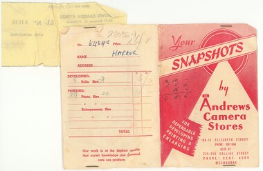 Ringwood and District Historical Society
Negative, Photographic negatives from Archie and Ruby Harker Collection April 1958
Archir Harker was married to Ruby Wilson and mentioned in the "Wielands of Heathmont "book. From Greg Coker: In August 2023, RDHS asked Greg Coker to scan a set of negatives. He was able to work out, through various notes, that the pictures were taken by J A Harker of 9 Grange St, Mont Albert in the mid 50s to the mid 60s. Most of the film was 9cm X 6cm B&W negatives. All pictures have been cropped and where appropriate, put through a light filter. They have been scanned at 1600ppi resulting in ~3meg B&W shots (~5meg for the half dozen colour shots). The Harkers certainly liked their hiking – they were ahead of their time. Images scanned from packet of negatives with name of Harker, and receipt dated April 1958. From Andrews Camera Store. (1 copy of each negative ordered) After scanning in 2023 by Greg Coker, the negatives were disposed and just the packet retained. Some photos may be duplciated in other VC Harker/Weiland family records if the original prints were donated. Greg's comments: 1958 – Original Negatives. Marysville Holiday. April 58 was when these were developed, as there was a note on the packet. There is a picture at the top of Woods Point that identifies Marysville.Your Snapshots, by Andrews Camera Stores, 69-71 Elizabeth St, Melbourne. For Dependable Developing Printing and Enlarging. -
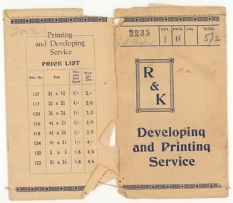
 Ringwood and District Historical Society
Negative, Photographic negatives from Archie and Ruby Harker Collection - Mid 1950's Mountains - possibly Grampians
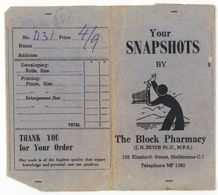
Archir Harker was married to Ruby Wilson and mentioned in the "Wielands of Heathmont "book. From Greg Coker: In August 2023, RDHS asked Greg Coker to scan a set of negatives. He was able to work out, through various notes, that the pictures were taken by J A Harker of 9 Grange St, Mont Albert in the mid 50s to the mid 60s. Most of the film was 9cm X 6cm B&W negatives. All pictures have been cropped and where appropriate, put through a light filter. They have been scanned at 1600ppi resulting in ~3meg B&W shots (~5meg for the half dozen colour shots). The Harkers certainly liked their hiking – they were ahead of their time. Images scanned from The Block Pharmacy packet of negatives, undated. After scanning in 2023 by Greg Coker, the negatives were disposed and just the packet retained. Some photos may be duplicated in other VC Harker/Weiland family records if the original prints were donated. Greg's comments: Mid 50s – Original B&W negatives; Seems to be a set of holiday snaps in mountain country – the Grampians I think. Your Snapshots by The Block Pharmacy (J.H. Beyer Ph.C, M.P.S.), 102 Elizabeth Street, Melbourne C1. Telephone MF 1380 -
 Ringwood and District Historical Society
Negative, Photographic negatives from Archie and Ruby Harker Collection - Early 1960's
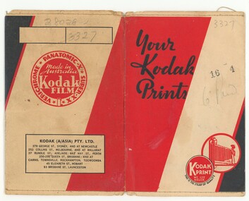
Archir Harker was married to Ruby Wilson and mentioned in the "Wielands of Heathmont "book. From Greg Coker: In August 2023, RDHS asked Greg Coker to scan a set of negatives. He was able to work out, through various notes, that the pictures were taken by J A Harker of 9 Grange St, Mont Albert in the mid 50s to the mid 60s. Most of the film was 9cm X 6cm B&W negatives. All pictures have been cropped and where appropriate, put through a light filter. They have been scanned at 1600ppi resulting in ~3meg B&W shots (~5meg for the half dozen colour shots). The Harkers certainly liked their hiking – they were ahead of their time. Images scanned from Kodak Print packet of negatives, undated. After scanning in 2023 by Greg Coker, the negatives were disposed and just the packet retained. Some photos may be duplicated in other VC Harker/Weiland family records if the original prints were donated. Greg's comments: Early 60s – Original Negatives. Best guess in terms of the date – Mrs Harker looks a touch older. Pictures of Mrs Harker at home with their cat and some mountain ranges, perhaps the other side of the Dandenong’s. Your Kodak Prints -
 Port Melbourne Historical & Preservation Society
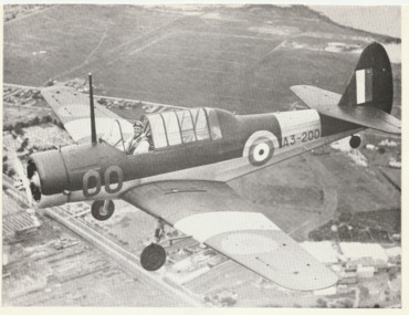
Photograph, Commonwealth Aircraft Corporation, Wackett Trainer, 22 Apr 1942
From a box of photographs in Nancy U'REN's papers used during research for her thesis, The Early Growth and Development of Sandridge (1976) and/or her book with Noel TURNBULL, A History of Port Melbourne (1983). The Wackett Trainer was designed in Australia and manufactured at the Commonwealth Aircraft Corporation factory on Fisherman's Bend. This is a cropped version of image AC0154 in the Australian War Museum. Wackett Trainer A3-200. Last of a batch of 200 built, flown by Mr J.O. CARTER, civilian production test pilot. Photographed by John HARRISON, from a Wirraway A20-584 flown by Mr K.M. FREWIN. [The AWM identifies the location as Fisherman's Bend but the coastline, particularly in the original AWM version, is clearly not Fisherman's Bend].Black and white photograph from the Commonwealth Aircraft Corporation showing the Wackett Trainer A3-200 airplane in flight. Last of a batch of 200 built, flown by Mr J.O. CARTER, civilian production test pilot. Photographed by John HARRISON, from a Wirraway A20-584 flown by Mr K.M. FREWIN.commonwealth aircraft corporation, wackett trainer, transport - aviation and aerodrome, nancy u'ren nee morris, j o carter -
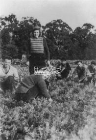
 Eltham District Historical Society Inc
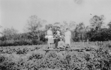
Photograph, At Bell Street, Eltham; from left: Helen Skipper, Matcham Skipper, Sonia Skipper and possibly Myra Skipper
At Bell Street, Fabbro Farm, Eltham; From left: Helen Skipper, Matcham Skipper, Sonia Skipper and possibly Myra Skipper, standing in the middle of a vegetable crop. The site of the Fabbro farm (Diamond Creek side land) is now called Barrack Bushlands. It is doubtful that Fabbro's farm holding was ever called Barrak Park, This title is fairly recent after the Shire of Eltham purchased the land, including the last section in 1993/94. About this time the area on the west side of Falkiner Street was purchased by a private developer and developed as housing. The area in Bell Street opposite the Eltham High School was purchased by the State Government is recent years and is called Fabbro Fields. The Fabbro Family operated their farm in Bell Street, Eltham. 1 black and white photographfabbro's farm, bell street, eltham, farming, helen skipper, vegetables, matchcam skipper, myra skipper, sonia skipper -
 Mt Dandenong & District Historical Society Inc.
Photograph, Clint Rowse and Staff
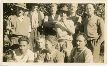
John Lundy-Clarke grew up in the Kalorama/Mt Dandenong area and later in life (1972-74) began to write a comprehensive history of the area working from an original settlement map in an effort to cover all areas. John Lundy-Clarke has identified the photograph as being of Clint Rowse and Staff at Olinda Creek Valley in 1939. The workmen are: Back row from right: Bob Daly, Dud Page, Harry Dyson, Bill Cavell, Len Child, Ken Williams. Front row from right: Clint Rowse, Jack Clarke, Bernie Page, Jack Johnson (with dog). The Rowse family had extensive raspberry crops but later changed to flowers. Daisy Rowse married Hubert Jeeves. Black and white photograph showing a group of 10 workmen, one holding a dog.The names Lenny Child, Dyson, Page, Bob Daly, Jackie Johnston, J Clarke, Clint Rowse are handwritten on the back by John Lundy-Clarkelen child, bob daly, clint rowse, jack johnston, bill cavell, ken williams, jack clarke, dud page, bernie page -
 Mt Dandenong & District Historical Society Inc.
Photograph
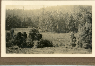
The photograph is from the album of Ivy Child and shows a shows an area of Kalorama that has been cleared to grow crops. Ivy May Child (1910 – 1989) was the daughter of Arthur Edward (Ted) Child (1878 – 1964) and Ethel May Madden (1888 – 1970). Ted Child was the son of Matthew Francis Child (1839 – 1933) and Martha Jeeves (1857 – 1926). He was the grandson of one of the early pioneers Francis Child. Ivy grew up on the family property on Childs Road and took many photographs. Most of these are glued into her photo album. The album covered the years from c1927 – 1932. Ivy married Henry William Burgess (1906 – 1968) in 1944. The photographs remain in their original state in the album with individual copies made. Black and white photograph with bushes in the foreground, a cleared area in the centre and thick trees behind.ivy child, kalorama, crops -
 Warrnambool and District Historical Society Inc.
Footwear - Child's boot, 1940s
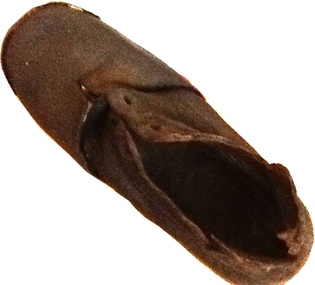
This small shoe (or boot) was found at Rosebrook, a small settlement between Warrnambool and Port Fairy, after the 1946 Western District floods. These floods are regarded as the worst in the history of European settlement in the Western District. At least five lives were lost, many small settlements and towns were isolated resulting in food shortages, onion and potato crops were ruined, 20 bridges were destroyed or damaged, roads were swept away, hundreds of farm animals perished and road and rail services were disrupted. The floods were the result of a very high rainfall in five successive days (658 points of rain in one 24 hours) and there was more flooding a week after the first major impact of the rains. A link to a major weather event in the South west.This is a small child’s brown shoe made of leather with a lace-up upper part (no laces) and a leather sole. The sides of the upper part of the shoe have broken away at the edges. As the shoe has been water-logged (it was found after the 1946 Western District floods) it has become hard and brittle. warrnambool, rosebrook western district floods, 1946, 1940's shoe -
 Ballarat Tramway Museum
Postcard, Sturt St. in the mid 1940's
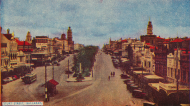
Printed colour postcard of photograph of Sturt St. in the mid 1940's looking from the top of a building in Grenville St. towards the West. Has a number of parked vehicles in kerbs, two people riding horses, a Vacuum Oil Co. truck in the bottom right hand corner and an SEC tram travelling west, just past the City Loop points. See Reg Item 675 for the same photograph - slightly cropped. Victorian Railways photograph. On rear the card has been ruled for address, stamp and titled postcard. Along the bottom edge is the publication details "ANSCOL - Australian Natural Scenic Colour - Thomas Tennant, 14 Jaques St., Chatswood N.S.W." trams, tramways, sturt st, postcards, sec, grenville st, tram 4 -
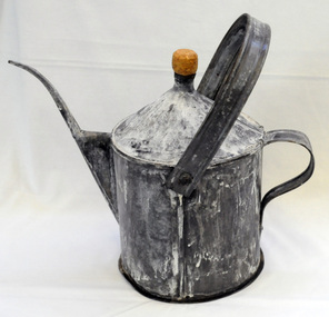 Orbost & District Historical Society
poison pot, Smith, R. & E, 1940's
This item was used on P.C. Toby Nixon and Grace Nixon's farm, "Rolling Downs" at Bete Bolong. During WW11 the farm grew carrots, red beet, cabbages, beans and maize. Because of labour shortages the government built a Prisoner of War Camp on Russell's Hill. The manager, Dick Northrope, used three Italian prisoners to frill ring small trees and shrubs between crop harvesting. The introduction of ‘frill ringing’ and poisoning with arsenical tree killers in the 1940's and 1950's helped reduce the amount of labour required and trees on more country were treated. This enabled the hill country at Bete Bolong to become more productive. The dead trees and shrubs were later cleared by Erle Broome's D7 caterpillar bulldozer. This was the first big area of 230 acres to be cleared in the Orbost district. Soon after entering World War 11 Australia was asked by Britain to accept and guard large numbers of 'enemy aliens' and prisoners of war. The British government felt that it could not afford to feed large numbers of prisoners and it was believed that once in Australia the internees would have no chance of escape. Eager to show solidarity with Britain's cause, Australia readily agreed and decided to place the prisoners in a number of different camps scattered around the country and guard them with reservists and soldiers too unfit to serve overseas. There was an internment camp at Bete Bolong, Orbost. This item is an example of an item used by the Italian P.O.W.'s residing there. It is also an example of an agricultural tool not commonly used today.A galvanized iron watering can which has been used to hold poison for ring barking trees (possibly arsenic). It has a narrow spout. There is a handle at the back and a folding handle on the top. The top is conical with an opening for a cork. agriculture prisoner-of-war-camp tree-removal land-clearing -
 Eltham District Historical Society Inc
Photograph, At Bell Street; from left: Maurie Fabbro, Myra Skipper, Unknown, Arthur Munday, Ian Robertson. Helen Comprione in front
At Bell Street, Fabbro Farm, Eltham; from left: Maurie Fabbro, Myra Skipper, Unknown, Arthur Munday, Ian Robertson. Helen Comprione in front - probably helping to pick a crop. The site of the Fabbro farm (Diamond Creek side land) is now called Barrack Bushlands. It is doubtful that Fabbro's farm holding was ever called Barrak Park, This title is fairly recent after the Shire of Eltham purchased the land, including the last section in 1993/94. About this time the area on the west side of Falkiner Street was purchased by a private developer and developed as housing. The area in Bell Street opposite the Eltham High School was purchased by the State Government is recent years and is called Fabbro Fields. The Fabbro Family operated their farm in Bell Street, Eltham. 1 black and white photographfabbro's farm, guido fabbro, bell street, arhur munday, eltham, helen comprione, ian robertson, maurice fabbro, myra skipper, picking, farming -
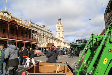
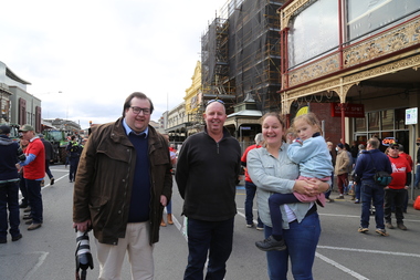 Victorian Farmers Federation
Photograph - Digital Photograph, Stop Ausnet Rally Ballarat - Katherine Myers, Scott Young, Charles Everist, 15 July 2022
VFF is seeking an appropriate framework to ensure farmers do not bear the cost of infrastructure on their farms. Overhead powerlines are proposed through the rich volcanic soils around Ballarat. This land supports 1200 jobs in processing in Ballarat. The towers would impact on the ability to irrigate crops, to use tractors around them, on biosecurity and on ability to use emergency equipment near them. VFF wants assurances that the managing entry to farm policy position will be adhered to and that a statewide strategic plan for renewable energy is prepared. https://www.vff.org.au/wp-content/uploads/2021/09/PS210901LG-Managing-Entry-to-Farms-adopted.pdf https://www.vff.org.au/wp-content/uploads/2021/09/VFF-Renewable-Energy-and-Energy-Efficiency-Policy-Statement-Meeting-172-June-2021.pdfadvocacy, renewable energy, farmers, protest, rally, managing entry to farm, victorian farmers federation, ballarat -
 Victorian Farmers Federation
Photograph - Digital Photograph, Stop Ausnet Rally Ballarat - post event scenes, 15 July 2022
VFF is seeking an appropriate framework to ensure farmers do not bear the cost of infrastructure on their farms. Overhead powerlines are proposed through the rich volcanic soils around Ballarat. This land supports 1200 jobs in processing in Ballarat. The towers would impact on the ability to irrigate crops, to use tractors around them, on biosecurity and on ability to use emergency equipment near them. VFF wants assurances that the managing entry to farm policy position will be adhered to and that a statewide strategic plan for renewable energy is prepared. https://www.vff.org.au/wp-content/uploads/2021/09/PS210901LG-Managing-Entry-to-Farms-adopted.pdf https://www.vff.org.au/wp-content/uploads/2021/09/VFF-Renewable-Energy-and-Energy-Efficiency-Policy-Statement-Meeting-172-June-2021.pdfadvocacy, renewable energy, farmers, protest, rally, managing entry to farm, victorian farmers federation, ballarat -
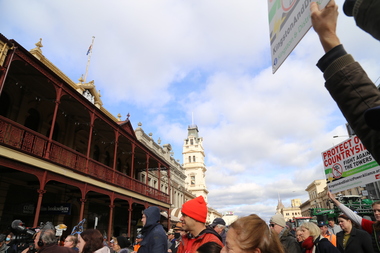 Victorian Farmers Federation
Photograph - Digital Photograph, Stop Ausnet Rally Ballarat, 15 July 2022
VFF is seeking an appropriate framework to ensure farmers do not bear the cost of infrastructure on their farms. Overhead powerlines are proposed through the rich volcanic soils around Ballarat. This land supports 1200 jobs in processing in Ballarat. The towers would impact on the ability to irrigate crops, to use tractors around them, on biosecurity and on ability to use emergency equipment near them. VFF wants assurances that the managing entry to farm policy position will be adhered to and that a statewide strategic plan for renewable energy is prepared. https://www.vff.org.au/wp-content/uploads/2021/09/PS210901LG-Managing-Entry-to-Farms-adopted.pdf https://www.vff.org.au/wp-content/uploads/2021/09/VFF-Renewable-Energy-and-Energy-Efficiency-Policy-Statement-Meeting-172-June-2021.pdfadvocacy, renewable energy, farmers, protest, rally, managing entry to farm, victorian farmers federation, ballarat