Showing 5918 items
matching east road
-
 Glen Eira Historical Society
Article - Stephen Family
... Orrong Road Glen Eira Road East St. Kilda Mansion Whittingham Geo ...This file has five items. Printed family tree from 1733 to 1856. Printed family tree from 1770 to 1939. Hand drawn family tree specific section from Mennell page 434. Four pages of handwritten notes from rate books, and a small amount of family research included as well. Newspaper article from The Age, 17/02/1973, mentioning author Virginia Woolt relation to James Stephen family tree. Handwritten notes from RHSV pioneer register. Handwritten notes on the Stephen family. Photocopy of entry on J.W. Stephen from Australian Dictionary of Biography 1851 – 1890.stephen james wilberforce., stephen mary anne sibella., stephen hart mary, stephen hart john, stephen hart susannah., stephen hart henrietta, stephen hart katherine., stephen hart thomas, stephen hart george, stephen hart edith, avoca grove, stephen george, orrong road, glen eira road, east st. kilda, mansion, whittingham geo, stephen anne atkinson., stephen james, stephen george milner elmslic., kooyong road, glen huntly road, glenhuntly road, gladstone parade, camden town, stephen francis john sydney., bureel, buxton mrs, shoobra, stephen sir george, caulfield, st. mary’s church, helenslea, riddell mrs, stephen william ravenscroft. -
 City of Moorabbin Historical Society (Operating the Box Cottage Museum)
Newsletter, City of Moorabbin Historical Society Jun 2010 pdf, June 2010
... jasper road east brighton... of moorabbin box william jasper road east brighton melbourne city ...The City of Moorabbin Historical Society was formed c 1960 by a group of Moorabbin residents who were concerned that the history of the area should be preserved. A good response to a call for items related to the historical area of Moorabbin Shire brought donations of a wide variety of artefacts which are now preserved by the current members of CMHS at Box Cottage Museum . Helen Stanley, Secretary of CMHS, began producing a Newsletter for members in April 2007 to provide current information and well researched items of historical interest. Helen Stanley has produced a bi-monthly Newsletter, 2007 - 2013, for the members of the City of Moorabbin Historical Society that contains well researched interesting historical items, notification of upcoming events, current advice from Royal Australian Historical Society , Museums Australia Victoria and activities of Local Historical Societies. The Newsletter is an important record of the activities of the CMHS. Photocopied Plan of ‘Two Acre Village c1853’ and notes about the Colonial City Morgue Melbourne c1888 7 x A4 paper printed on 1 side Issue 17 of the bi-monthly, City of Moorabbin Historical Society Newsletter produced by Society member and Secretary, Mrs Helen Stanley in June 2010. Notice of meeting June 17th and recent death of Mrs May Curtis,CMHS member. June 5th , Robina Naughton, CMHS, represented Box Cottage at the 'Fun4over50s' expo at Moorabbin Town Hall. Mr Laurie Lewis donated the 'original water pump' from the first Box Cottage and has provided a list of the commercial properties around Box Cottage c 1900, as he remembers. An application to Glen Eira City Council for a Public Toilet at Box Cottage for visitors and volunteers. A volunteer has joined CMHS following our enrolment with 'Volunteering Glen Eira'. State Library of Victoria has approved CMHS for the 'Vicnet' program where Box Cottage Museum can be promoted. Helen provides a précis, of 4 A4 pages, describing ‘The City Morgue in Colonial Melbourne’ printed in Provenance Journal No3 November 2004.CITY of MOORABBIN HISTORICAL SOCIETY / JUNE 2010 NEWSLETTERcity of moorabbin historical society, stanley helen, curtis may, graham street mckinnon, curtis geoff, moorabbin town hall, lewis laurie, lewis grace, lewis timber pty. ltd., melbourne, moorabbin, brighton, cheltenham, ormond, bentleigh, market gardeners, pioneers, early settlers, moorabbin shire, box cottage museum, water pump, elster creek, volunteering glen eira, state library of victoria, vicnet, dendy henry, dendy’s special survey 1841, mclean n, box henry, joyce park ormond, city of moorabbin, box william, jasper road east brighton, melbourne city morgue, cooke simon, brown mwy andrew -
City of Moorabbin Historical Society (Operating the Box Cottage Museum)
Education kit - School Writing Slate early 20thC, 20thC
... st stephens c of e school tucker road east brighton... stephens c of e school tucker road east brighton A writing slate ...School children learned to write using a slate From 1880’s to mid 1950’s in most schools, very young children first learned to write their letters in sand trays using their fingers or a stick. When about 6, they progressed onto writing on slates . The board was made from a piece of quarry slate set in a wooden frame. A slate pencil (not chalk) was used to form the letters. This slate pencil was often sharpened on the school wall. The advantage of slates over paper was that they could be wiped clean and used again and again. Until the mid 20thC paper was expensive . After the pupil wrote on the Slate, the work was checked by the teacher and then erased for a new task Children had to bring a dampened cloth or sponge to school so that they could clean the slate and start again. The pioneer settlers in the Moorabbin Shire area valued education and established schools for their children in Cheltenham and East Brighton c1860's This writing slate is typical of the type used up to the mid 20th Century in preparatory classes.A writing slate in a wood frame used by school children from c1880s to c1950sschools, education, writing equipment, slate writing boards, victoria melbourne, market gardeners, pioneer, settlers, cheltenham state school no. 84., bentleigh east state school no. 2083, st stephens c of e school tucker road east brighton -
City of Moorabbin Historical Society (Operating the Box Cottage Museum)
Education kit - Wood shaft writing pens and nibs, Steel Nib Manufacturer, mid 20thC
... st stephens c of e school tucker road east brighton... st stephens c of e school tucker road east brighton pen steel ...A dip pen usually consists of a metal nib with capillary channels like those of fountain pen nibs, mounted in a handle or holder, often made of wood. Dip pens have no ink reservoir, so the user must recharge the ink from an ink bowl or bottle to continue drawing or writing. Dip pens emerged in the early 19th century, when they replaced quill pens and were generally used before the development of fountain pens in the later 19th centuryThe pioneer settlers in the Moorabbin Shire area valued education and established schools for their children in Cheltenham and East Brighton c1860's These wood shaft pens and steel nibs are typical of the type used up to the mid 20th Century in school classes.3 wood shaft writing dip pens with steel nibs schools, education, writing equipment, victoria melbourne, market gardeners, pioneer, settlers, cheltenham state school no. 84., bentleigh east state school no. 2083, st stephens c of e school tucker road east brighton, pen steel nibs -
 City of Moorabbin Historical Society (Operating the Box Cottage Museum)
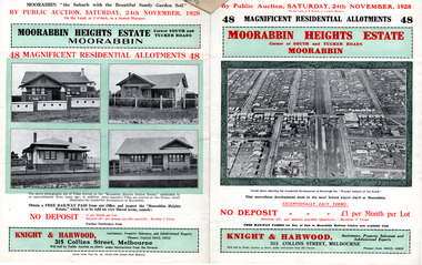
Flyer - Moorabbin Heights Estate, Moorabbin, 1928
... Cottage Museum) Joyce Park Jasper Road Ormond melbourne The train ...The train line from the city to Frankston was electrified which intensified the sale in the municipality of Moorabbin, particularly land which was in the vicinity of the railway stations.Example of the progress of the Municipality of MoorabbinAdvertising flyer for auction of real estate sales - plan of building blocks for saleMoorabbin Heights Estate, Moorabbin - 48 residential allotments - Auction Saturday 24 November 1928moorabbin, bentleigh, east bentleigh, south road, tucker road, hinkler avenue, real estate, auction -
Whitehorse Historical Society Inc.
Document, William James Moffatt, 2013
... Mitcham melbourne Moffatt William James Mahoneys Road Burwood East ...Biographical notes about William James Moffatt, orchardist in Blackburn.Biographical notes about William James Moffatt, orchardist in Blackburn.Biographical notes about William James Moffatt, orchardist in Blackburn.moffatt, william james, mahoneys road, burwood east, orchardists, bakers road blackburn -
 Whitehorse Historical Society Inc.
Photograph, Burwood Heights Uniting Church
... Cnr Burwood Hwy & Blackburn Road East Burwood... & Blackburn Road East Burwood Burwood Heights Uniting Church East ...Burwood Heights Uniting Church East Burwood.burwood heights uniting church, cnr burwood hwy & blackburn road east burwood -
 Whitehorse Historical Society Inc.
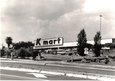
Photograph - First K mart store in Australia, Kmart
... Cnr Burwood Hwy & Blackburn Road East Burwood... . Situated on the corner of Blackburn Road and Burwood Hwy East...Whitehorse Historical Society Inc. 2-10 Deep Creek Road ...Black and white photograph of the first Kmart in Australia . Situated on the corner of Blackburn Road and Burwood Hwy East Burwood.kmart, store, cnr burwood hwy & blackburn road east burwood -
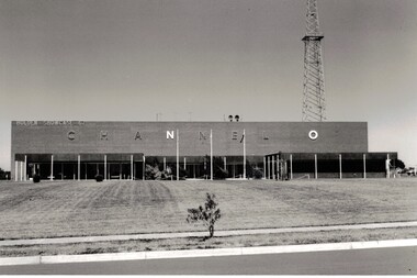 Whitehorse Historical Society Inc.
Photograph - Channel O Television Studio, Channel O Television Studio
... Hawthorn Road East burwood.... Channel 0 TV Studios Hawthorn Road East burwood TV Studio Black ...Black and white photograph of Channel O in 1964 . Opened by Reg Ansett and changed to ATV10 in January 1980.Black and white photograph of Channel O in 1964 . Opened by Reg Ansett and changed to ATV10 in January 1980.channel 0 tv studios, hawthorn road east burwood, tv studio -
 City of Ballarat Libraries
Photograph, View south west along Barkly Street from Ballarat Fire Station Tower, Ballarat East
... street east ballarat main road len t frazer reserve View south ...An image from the Herbert Richmond collection, gifted in 1982 to the Ballarat Library. The collection contains approximately 200 photographs of Ballarat and district in the 1940s, 50s and 60s, as well as photo albums, glass negatives and other memorabilia. Herb Richmond was a keen photographer, a foundation member and a life member of the Ballarat Camera Club, and a photographer with the Ballarat Courier during the 1940s. The Ballarat Camera Club named an annual award after him. Mr Richmond died in 1981 aged 79. These images were digitally re-photographed by members of the Ballarat Camera Club in September 2006.barkly street, east ballarat, main road, len t frazer reserve -
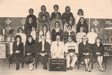 Bialik College
Photograph, Staff, Hawthorn East, 1981, 1981
... Bialik College 429 Auburn Road Hawthorn East 3123 melbourne ...Hawthorn East campus staff, 1981. Please contact [email protected] to request access to this record.hawthorn east campus, auburn road, 1980s -
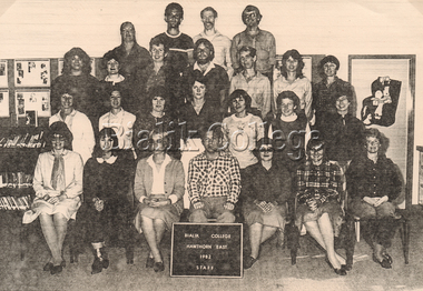 Bialik College
Photograph, Staff, Hawthorn East, 1982, 1982
... Bialik College 429 Auburn Road Hawthorn East 3123 melbourne ...Staff, Hawthorn East campus, 1982. Please contact [email protected] to request access to this record.hawthorn east campus, auburn road, 1980s -
 Bialik College
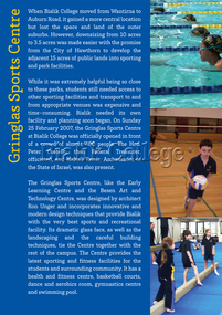
Exhibition Panel, 70th Anniversary: Gringlas Sports Centre, 2012
... Bialik College 429 Auburn Road Hawthorn East 3123 melbourne ...Panel from the exhibition held to celebrate the College's 70th anniversary in 2012. Please contact [email protected] to request access to this record.sport, hawthorn east campus, auburn road, history, 2000s -
 Ballarat Tramway Museum
Photograph - Digital image, Dick Jones, W3 661 outbound in St Kilda Road, Dec. 1964
... Kilda Road East Brighton tram 661 Digital Image of MMTB tram W3 ...Demonstrates one of the Museum's trams in service in Melbourne.Digital Image of MMTB tram W3 661 outbound in St Kilda Road, approaching Doman Junction. Tram has destination of East Brighton, Route 64 and an advertisement for Proofkote (rain wear protection?) BP House in the background. Photo December 1964. Photo reference from Dick Jones - 661_StKildaRd_DickJones_6412MIns.23.04trams, tramways, w3 class, st kilda road, east brighton, tram 661 -
Kew Historical Society Inc
Plan - Burke Road Junction Estate, East Kew, 1940
... Burke Road Junction Estate, East Kew... this is an example. Subdivisions -- Kew East (Vic.) Burke Road Junction ...Subdivision plans and real estate flyers/brochures reveal a number of aspects of urban development and history. The Kew Historical Society's collection of these plans, as well as advertisements extracted from magazines, cover key aspects of community development and architectural history of Kew and Kew Eat as well as surrounding suburbs. While most of the plans in the collection were gifted to the Society by the former City of Kew, a number of other plans and advertisements have been donated by individuals, of which this is an example.Original 4-page bifold brochure advertising the Burke Road Junction Estate in Kew East. Advertised for sale in 1940, the estate comprised 16 'Central Allotments' fronting High Street, Kilby Road, and Glass Street. Pages 1 & 4, the front and back covers, includes a panoramic photograph of the junction which features a number of shops still extant, but also with buildings long demolished and redeveloped. These include the petrol station and the dairy on the southeast and southwest corners of Burke Road and High Street/Doncaster Road. The dairy includes a statue of a cow on its roof. Pages 2 & 3 include a detailed plan of the estate. subdivisions -- kew east (vic.), burke road junction estate -
 Kew Historical Society Inc
Plan - Subdivision Plan, Goldthorns Hill Estate, 1925
... Argyle Road -- Kew East (Vic.)... -- Kew East (Vic.) Argyle Road -- Kew East (Vic.) Lady Brassey ...Pru Sanderson, in her groundbreaking ‘City of Kew Urban Conservation Study : Volume 2 - Development History’ (1988), summarised the periods of urban development and subdivisions of land in Kew. The periods that she identified included 1845-1880, 1880-1893, 1893-1921, 1921-1933, 1933-1943, and Post-War Development. These periods were selected as they represented periods of rapid growth or decline in urban development. An obvious starting point for Sanderson’s groupings involved population growth and the associated economic cycles. These cycles also highlighted urban expansion onto land that was predominantly rural, although in other cases it represented the decline and breakup of large estates. A number of the plans in the Kew Historical Society’s collection can also be found in other collections, such as those of the State Library of Victoria and the Boroondara Library Service. A number are however unique to the collection.The Kew Historical Society collection includes almost 100 subdivision plans pertaining to suburbs of the City of Melbourne. Most of these are of Kew, Kew East or Studley Park, although a smaller number are plans of Camberwell, Deepdene, Balwyn and Hawthorn. It is believed that the majority of the plans were gifted to the Society by persons connected with the real estate firm - J. R. Mathers and McMillan, 136 Cotham Road, Kew. The Plans in the collection are rarely in pristine form, being working plans on which the agent would write notes and record lots sold and the prices of these. The subdivision plans are historically significant examples of the growth of urban Melbourne from the beginning of the 20th Century up until the 1980s. A number of the plans are double-sided and often include a photograph on the reverse. The Goldthorns Hill Estate subdivision was first put up for auction in 1925. The subdivision took its name from the mansion ‘Goldthorns’, shown on the plan between Normanby Road and Lady Loch’s Drive. Contemporary advertisements describe forty-three home sites being fro sale, yet only forty-one appear on this plan. Buyers were lured by the prospect of the proposed extension of the Burke Road tram to High Street. Discerning buyers were advised that only one house could be built per allotment, and that houses needed to be constructed of brick, stone or concrete and have a slate or tiled roof.goldthorns avenue -- kew east (vic.), lady loch drive -- kew east (vic.), argyle road -- kew east (vic.), lady brassey drive -- kew east (vic.), campbell street -- kew east (vic.), goldthorns -- kew (vic.), subdivisions -- kew east (viv.), goldthorns hill estate -
University of Melbourne, Burnley Campus Archives
Photograph - Black and white print, Aerial View of Burnley Campus, 1977
... in the bend of the Yarra River, Glenferrie Road to the East Swan... river glenferrie road east swan street aerial view Framed ...Framed enlargements. (A) Burnley College and surrounding suburbs showing the nearly constructed Freeway, the College in the bend of the Yarra River, Glenferrie Road to the East Swan Street to the North. (B) Enlargement of (A) showing detail of Burnley College.burnley college, suburbs, freeway, yarra river, glenferrie road, east swan street, aerial view -
Canterbury History Group
Photograph - East Camberwell Garage, c1920 - 1930
... melbourne Canterbury East Camberwell Canterbury Road Petrol Stations ...Black and white photograph of the T.J. Francis East Camberwell Motor Garage, 68 Canterbury Road Canterbury. At the front of the garage are eight cars and the staff.canterbury, east camberwell, canterbury road, petrol stations, garage workers, vintage cars, telegraph and light poles, t.j. francis, street trees -
Canterbury History Group
Photograph - East Camberwell Garage, c1920
... melbourne Canterbury East Camberwell Canterbury Road Petrol Stations ...Black and white photograph of the T.J.Francis, East Camberwell Garage with several cars outside and staffcanterbury, east camberwell, canterbury road, petrol stations, garage workers, vintage cars, t.j. francis, street trees -
Canterbury History Group
Photograph - A.J.C. Motors - East Camberwell Garage, C1930
... melbourne Canterbury East Camberwell Canterbury Road Petrol Stations ...Black and white photograph of A.J.C. Motors and East Camberwell Garage ( prop. A.J.Cowan). Eight vintage cars are at the front of the garage and 12 members of the staff c.1930.canterbury, east camberwell, canterbury road, petrol stations, petrol pumps, vintage cars, a.j.c. motors, east camberwell garage, cowan> a.j., t.j. francis, power and telegraph lines, garage workers -
 Melbourne Tram Museum
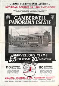
Ephemera - Real estate sale, Cranny Sambell & Co, "Camberwell Panorama Estate", Oct. 1923
... Panorama Estate East Camberwell Doncaster Road Bulleen Road tram 20 ...Pamphlet advertising the sale of land at the "Camberwell Panorama Estate" - Doncaster and Bulleen Road 13-10-1923. Gives terms of sale, photos showing the views and a nearby shopping centre. Has a large photo of MMTB No. 20 on the front cover. The tramcar is of the Hawthorn Tramways Trust four-door bogie type. MMTB No 20 was an ex-Prahran and Malvern single trucker or small tram A class. Gives details of the 110 lots to be sold, terms, location, and that the tram was proposed to be extended to the corner. This extension took place in 1937. The locality plan shows proposed plans for tram lines in Belmore Road and Burke Road north of Whitehorse Road. Demonstrates the style of land sale pamphlet including the availability of tram services to prospective purchasers.Pamphlet - folded - printed in two colours of cream coloured paper with photographs and plans.has pencil notes on the top of the front page.sale of land, trams, real estate, camberwell panorama estate, east camberwell, doncaster road, bulleen road, tram 20 -
 Melbourne Tram Museum
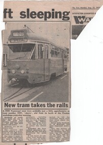
Newspaper, The Sun, "New Tram takes the rails", 27/08/1973 12:00:00 AM
... 1041 PCC class Plenty Road East Preston Newspaper Clipping ...Newspaper Clipping - from The Sun 27/8/1973 titled "New Tram takes the rails" about the launch of the prototype tram 1041 the previous day. Notes the launch with the Premier Mr. Hamer, the Transport Minister Mr Wilcox and quotes drive John Newland. Has a photograph of the tram showing Special.trams, tramways, prototype tramcar, launch, preston workshops, tram 1041, pcc class, plenty road, east preston -
 Melbourne Tram Museum
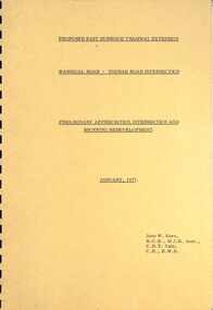
Document - Report, John Knee, "Warragul Road - Toorak Road Intersection", Jan. 1977
... Report - "proposed East Burwood Tramway Extension - Warragul Road ...Report - "proposed East Burwood Tramway Extension - Warragul Road - Toorak Road Intersection - Preliminary Appreciation intersection and shopping redevelopment - Jan. 1977". Prepared by John W Knee for the MMTB and others. Looks at the intersection, how the shopping centre could be accessed, possible Mall development, residential issues, passenger facilities and pedestrian capacity. Includes a number of possible access routes for the area. None were applied when the tram line was extended.Yields information about a consideration for the extension of the Toorak Road line to East Burwood in 1977.Comb bound report with clear plastic covers, brown covers, 17 A4 pagesmmtb, east burwood, toorak road, warragul road, new tramways, john knee -
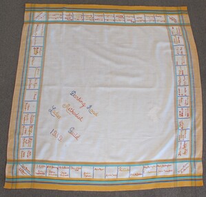 Uniting Church Archives - Synod of Victoria
Textile - Tablecloth
... Darling Road East Malvern Methodist Church...Methodist Ladies Guild Darling Road East Malvern Methodist ...Square tablecloth with text embroidered in squares around edges. The cloth has a yellow, blue, green and red border."Darling Road Methodist Ladies Guild 1939"methodist ladies guild, darling road east malvern methodist church -
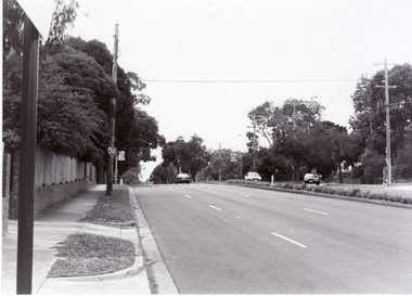
 Glen Eira Historical Society
Railways in Caulfield
... Photograph of Glen Huntly Road looking east... of Glen Huntly Road looking east Railways in Caulfield ...Photograph of Glen Huntly Road looking eastglen huntly, glen huntly road -
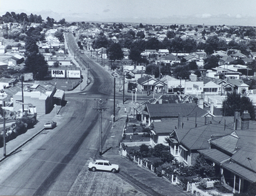
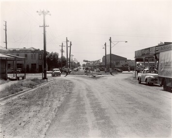 City of Kingston
Photograph - Black and white, c. 1956
... and East Boundary roads, Bentleigh East. Several cars are visible... of the intersection of Centre and East Boundary roads, Bentleigh East. Several ...Strip shopping and ample parking were features of suburbs in the middle of the twentieth centuries. Cars were still considered a luxury, although that would soon change, and local, independent shops serviced local areas.During the post-war years, the municipality of Moorabbin experienced a population boom. The 'newcomers' were predominantly returnees from the war who were marrying and establishing families; those from the old inner-suburban areas who were moving away from rented premises to establish their own homes on cheap land. The 1950s were a time of immense growth for the area now known as City of Kingston.Black and white photograph of the intersection of Centre and East Boundary roads, Bentleigh East. Several cars are visible both in the foreground and background, and the intersection includes a roundabout. The street is lined with poles to carry electricity cables, and the roundabout is dotted with four poles for electric street lights.Handwritten in blue ink: 56 - 230 Handwritten in red ink: 82% Handwritten in black ink: Ch. 6shopping strip, cars, suburbs -
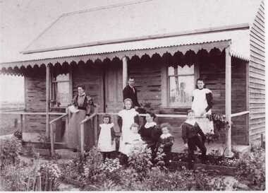 Clunes Museum
Photograph, ROGER PURCELL, BALLARAT
... . TOURELLO ROAD EAST.1898... PHOTOGRAPH [COPY] OF FAMILY AT ROSE COTTAGE. TOURELLO ROAD EAST.1898 ...ORIGINAL PHOTOGRAPH OWNED BY MRS. LENA COOK OF CASTLEMAINE RD. CRESWICKBLACK AND WHITE PHOTOGRAPH [COPY] OF FAMILY AT ROSE COTTAGE. TOURELLO ROAD EAST.1898local history, photography, photographs, roberts family. -
Whitehorse Historical Society Inc.
Map, City of Nunawading, 1980?
... of Burwood Highway and east of Springvale Road.... to south of Burwood Highway and east of Springvale Road. City ...Map of the City of Nunawading showing streets to south of Burwood Highway and east of Springvale Road.Map of the City of Nunawading showing streets to south of Burwood Highway and east of Springvale Road.Map of the City of Nunawading showing streets to south of Burwood Highway and east of Springvale Road.city of nunawading, historical -
 Whitehorse Historical Society Inc.
Photograph, Canterbury Road, Blackburn, 6/01/2001 12:00:00 AM
... looking east from Blackburn Road.... and white photograph of Canterbury Road Blackburn looking east from ...Black and white photograph of Canterbury Road Blackburn looking east from Blackburn Road.canterbury road, blackburn., blackburn road -
Whitehorse Historical Society Inc.
Book, Nubrik heritage value assessment, 1/12/1999 12:00:00 AM
... 78 Middleborough Road, Burwood East. Prep. for the owners..., 78 Middleborough Road, Burwood East. Prep. for the owners... Mitcham melbourne 78 Middleborough Road, Burwood East. Prep ...Heritage value assessment of the proposed H062 former Brick Industries Ltd / Brick and Pipe Industries Ltd (Nubrik) BrickworksHeritage value assessment of the proposed H062 former Brick Industries Ltd / Brick and Pipe Industries Ltd (Nubrik) Brickworks, 78 Middleborough Road, Burwood East. Prep. for the owners, Reading Entertainment Australia Pty Ltd [by] D.V. Bick. Abridged version.Heritage value assessment of the proposed H062 former Brick Industries Ltd / Brick and Pipe Industries Ltd (Nubrik) Brickworksbrick industries limited, middleborough road, burwood east, no. 78, brickworks, quarries, reading entertainment australia pty ltd