Showing 465 items matching "freeway"
-
 Whitehorse Historical Society Inc.
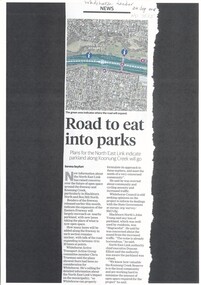
Article, Road to Eat Into Parks, 2018
Plans for the North East Link indicate parkland along Koonung Creek will go.Plans for the North East Link indicate parkland along Koonung Creek will go.Plans for the North East Link indicate parkland along Koonung Creek will go.north east link, koonung creek, blackburn north, eastern freeway, whitehorse active transport action group, city of whitehorse, bicycle paths -
 Whitehorse Historical Society Inc.
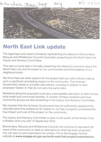
Article, North East Link Update, 2019
The alliance of Boroondara, Banyule and Whitehorse councils have been presenting concerns about option A to the North East Link Inquiry and Advisory Committee regarding the impact on the community.The alliance of Boroondara, Banyule and Whitehorse councils have been presenting concerns about option A to the North East Link Inquiry and Advisory Committee regarding the impact on the community.The alliance of Boroondara, Banyule and Whitehorse councils have been presenting concerns about option A to the North East Link Inquiry and Advisory Committee regarding the impact on the community.north east link, freeways -
 Rutherglen Historical Society
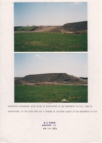
Image, W. H. Pleming, 13/10/1992
Two colour photographs printed on A4 paper with typed caption and a donor stamp. Date of photos in bottom right hand of each image.Date on images: "92-10-13" Caption below photos: "Asphelting aggregate stock piled at Springhurst at map reference 512-927, used at Springhurst on the Hume Free Way & crushed at Chiltern Quarry at map reference 671-969."hume freeway, chiltern quarry, road works -
 Ballarat Heritage Services
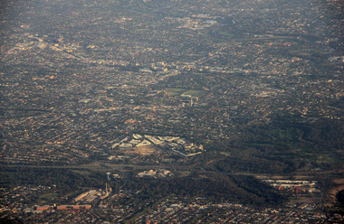
Photograph - Digital photographs, L.J. Gervasoni, Kew and Hawthorn from the air, c2017
Digital images of the Melbourne suburb od Kew and Hawthorn from the air.hawthorn, camberwell, kew junction, eastern freeway, camberwell junction, glenferrie, kew cottages, willsmere, melbourne, aerial, cityscape, landscape, kew, yarra river, aerial photograph -
 Whitehorse Historical Society Inc.
Photograph, EastLink
Series of coloured photos, commenced in 2005, of the EastLink project at the Deep Creek Road siteeastlink, thiess - john holland, deep creek road, mitcham, eastern freeway extension -
 Kew Historical Society Inc
Archive (Sub-series) - Subject File, Kew Historical Society, North East Link, 2019
Various partiesReference, Research, InformationSecondary Values (KHS Imposed Order)Subject file containing documents relating to the development and impact of of North East link in Melbourne.north-east link, transport infrastucure - kew (vic), roads - kew (vic), streets - kew (vic), freeways - kew (vic)north-east link, transport infrastucure - kew (vic), roads - kew (vic), streets - kew (vic), freeways - kew (vic) -
 Kew Historical Society Inc
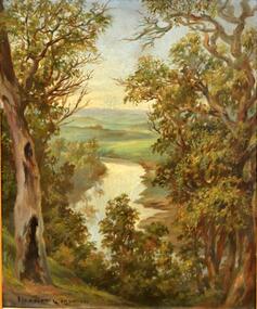
Painting, Herbert J Woodhouse, River Yarra Near Dights Falls, c.1892
Herbert James Woodhouse (1854-1937) was born in Essex and arrived in Australia with his family in 1857. A painter-lithographer like his father and three of his brothers, he was a prizewinner in the South Australian Society of Arts exhibition of 1885. He also received commendations in exhibitions at the Victorian Academy of Arts and the New South Wales Arts Society. At an exhibition of his paintings at Scott’s Hotel in Collins Street in 1892, the reviewer for Table Talk noted that the ‘artist paints almost solely in the open air, and his studies are generally carried out during the trips of the Victorian Sketching Club’. One of the paintings singled out for praise was: ‘A very effective river scene at Willsmere, aptly named A Midstream Mirror, ... a picture powerful in its effective reflection of sunlight in the river.’ Herbert Woodhouse died in Geelong in June 1937, aged 82, and was buried in the Eastern Cemetery. A number of his sketchbooks are held in the collection of the State Library of Victoria.Framed oil painting on board of the River Yarra at Studley Park, Kew, by Herbert James Woodhouse (1858-1937). The artist has framed the narrow painting with trees in the foreground and a view of the Yarra River and rolling hills in the background. Verso, written by artist: "River Yarra Near Dights Falls"australian art - 19th century, herbert james woodhouse (1854-1937), yarra river - studley park -
Kew Historical Society Inc
Journal, The Kewriosity Sheet Vol.2 No.2 : July 1980
What's doing in Kew for July / p1. The origins of Kew / Elizabeth Mackie p1. Yooralla Seminars / p1. Lyrebirds / p1. Printers err / p1. East Kew Baptist Church news / p2. Kew Elder Citizens Club fete / p2. National Boys' Choir [Foster Parents Care Centre] / p2. Portrait of Kew [Exhibition - Donald Cameron; Gwen Walker] / p2. "Teenagers" - a seminar for professional staff who work with teenagers / p2. Kew Garden Club / p2. Fashion Parade [Wellington Clothes; St David’s Uniting Church] / p2. Poets Corner / p2. Council News [Urgently required school crossing supervisors; Search for outstanding young Australians; After School Programme; C.R.B. - Route E6 Environmental effects [Eastern Freeway] / p2.The Kewriosity Sheet (1979-83) was first published in the City of Kew (Victoria) in June 1979 as a two-sided 'community newssheet'. It aimed to: 'share news about Kew happenings and Kew people, and to exchange ideas about living in Kew'. Later issues gradually evolved into a 4-page, quarto sized publication. The Kewriosity Sheet was superseded by the Kew Council publication 'Kewriosity' (1983-1994).non-fictionWhat's doing in Kew for July / p1. The origins of Kew / Elizabeth Mackie p1. Yooralla Seminars / p1. Lyrebirds / p1. Printers err / p1. East Kew Baptist Church news / p2. Kew Elder Citizens Club fete / p2. National Boys' Choir [Foster Parents Care Centre] / p2. Portrait of Kew [Exhibition - Donald Cameron; Gwen Walker] / p2. "Teenagers" - a seminar for professional staff who work with teenagers / p2. Kew Garden Club / p2. Fashion Parade [Wellington Clothes; St David’s Uniting Church] / p2. Poets Corner / p2. Council News [Urgently required school crossing supervisors; Search for outstanding young Australians; After School Programme; C.R.B. - Route E6 Environmental effects [Eastern Freeway] / p2.community publications --- kew (vic.), the kewriosity sheet, newsletters - kew (vic.) -
Kew Historical Society Inc
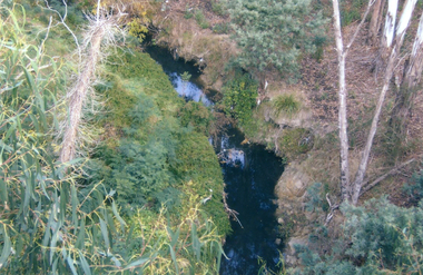
Collection, Floods in North Kew (Series), 1929–1934
Flooding of the Yarra Valley, including that section of the Yarra bordering Kew and Kew East in the north and west of the municipality, was a regular occurrence. Extreme flood events of the Yarra River are recorded to have occurred in 1891, 1901, 1916, 1923 and 1934. The Municipality of Kew's response to these floods was to enact planning decisions restricting residential development in flood prone areas following the floods of 1916, 1921 and 1934. While floods continued after the development of the Upper Yarra Reservoir (construction 1948-57), the regularity and extent of these inundations diminished. Natural disasters had an impact on the development and settlement of Melbourne and its suburbs. Flooding in the Melbourne region was a regular event in the nineteenth and for most of the twentieth centuries. Changes in the impact of natural disasters could occur due to a number of factors. This collection of small snapshots, mostly taken from Kellett Grove in North Kew, provide provenanced evidence of flooding in the area before the development of the unnatural flood barrier that is the Eastern Freeway.Collection of 16 monochrome photographs, annotated on verso by different hands, of the flooding of the River Yarra in North Kew in the third and fourth decades of the twentieth century [1920s & 1930s]. Individual photos include the dates of different floods. Many of the photos were taken from the rear of 8 Kellett Grove; a house still extant in 2023yarra river -- north kew, floods -- yarra valley, floods -- north kew, floods -- 1929, floods -- 1934, natural disasters -- kew -
 Kew Historical Society Inc
Photograph - View of the Yarra River from 8 Kellett Grove, North Kew, 1948
North Kew, now divided between Kew and Kew East, bordered the Yarra River. As such, it was a region subject to flooding in the Yarra Valley. Development beyond this point (ie Kellett Grove) was limited by the City of Kew's planning regulations. Prior to urban development, the area since European settlement and the first land sales in the district in the 1840s, had been used for dairy farming. The view from the rear of 8 Kellett Grove predates the construction of the Eastern Freeway so provides a rare view of the area before it was built.Small sepia snapshot taken from the back yard of a house at 8 Kellett Grove, in what was then known as North Kew. A tower of the Kew Asylum on the top left of the horizon assist the viewer to recognise that the land to the left of the river is in Kew and Studley Park.Verso: NORTH KEW 1948 / Stamped 51019yarra river -- north kew, kellett grove -- north kew -
 Eltham District Historical Society Inc
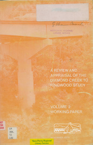
Book, A Review and Appraisal of the Diamond Creek to Ringwood Study, volume 2, working paper, by Loder and Bayly, 1979
Volume 2: Working papers. This report is a review and appraisal of the Outer Ring Road Study Diamond Creek to Ringwood prepared for The Road Planning Liaison Committee by the Joint Road Planning Group for the The City of Doncaster & Templestowe and The Shire of Eltham by Loder & Bayly Planning & Engineering Consultants. "This paper attempts to set a framework for an evaluation of the recommended road link between Diamond Creek and Ringwood." Various perspectives are examined. Includes fold out maps.91 p, maps, 27 cm.melbourne ring road, roads, freeways -
 Eltham District Historical Society Inc
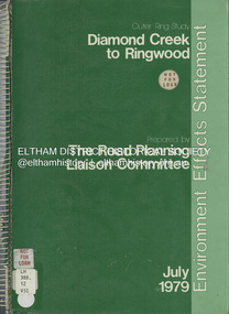
Book, The Road Planning Liaison Committee, Outer Ring Study, Diamond Creek to Ringwood: Environmental Effects Statement, July 1979
Prepared by The Road Planning Liaison Committee. The Outer Ring Study, Diamond Creek to Ringwood was a long term planning study carried out under the direction of the Road Planning Liaison Committee for the Government of Victoria. .. The basic aim of the .. Study was to determine the most appropriate future road system in the area between Diamond Creek and Ringwood, consistent with local and regional concerns and the environment of the area, with a view to seeking an emendment to the Metropolitan Planning Scheme to preserve the option to implement an appropriate road system some time in the future if this was considered necessary.non-fictionPrepared by The Road Planning Liaison Committee. The Outer Ring Study, Diamond Creek to Ringwood was a long term planning study carried out under the direction of the Road Planning Liaison Committee for the Government of Victoria. .. The basic aim of the .. Study was to determine the most appropriate future road system in the area between Diamond Creek and Ringwood, consistent with local and regional concerns and the environment of the area, with a view to seeking an emendment to the Metropolitan Planning Scheme to preserve the option to implement an appropriate road system some time in the future if this was considered necessary.roads, freeways, melbourne ring road -
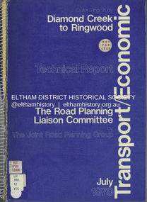 Eltham District Historical Society Inc
Book, The Joint Road Planning Group, Outer Ring Study, Diamond Creek to Ringwood: Technical Report Transport and Economic Evaluation, July 1979
Prepared for The Road Planning Liaison Committee by The Joint Road Planning Group. The Outer Ring Study, Diamond Creek to Ringwood was a long term planning study carried out under the direction of the Road Planning Liaison Committee for the Government of Victoria. .. The basic aim of the .. Study was to determine the most appropriate future road system in the area between Diamond Creek and Ringwood, consistent with local and regional concerns and the environment of the area, with a view to seeking an emendment to the Metropolitan Planning Scheme to preserve the option to implement an appropriate road system some time in the future if this was considered necessary. This technical report discusses, in detail, the transport and economic aspects of the investigation.. the techniques used take into account the long term implications of a range of possible travel cost policies and options and land use strategies.non-fictionPrepared for The Road Planning Liaison Committee by The Joint Road Planning Group. The Outer Ring Study, Diamond Creek to Ringwood was a long term planning study carried out under the direction of the Road Planning Liaison Committee for the Government of Victoria. .. The basic aim of the .. Study was to determine the most appropriate future road system in the area between Diamond Creek and Ringwood, consistent with local and regional concerns and the environment of the area, with a view to seeking an emendment to the Metropolitan Planning Scheme to preserve the option to implement an appropriate road system some time in the future if this was considered necessary. This technical report discusses, in detail, the transport and economic aspects of the investigation.. the techniques used take into account the long term implications of a range of possible travel cost policies and options and land use strategies.melbourne ring road, roads, freeways -
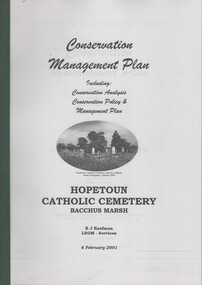 Bacchus Marsh & District Historical Society
Booklet, Conservation Management Plan Hopetoun Cemetery Bacchus Marsh
The Hopetoun Cemetery is located just a few kilometers east of Bacchus Marsh and is adjacent to the Western Freeway between Melton and Bacchus Marsh. This small cemetery is one of the oldest Catholic cemeteries in Victoria outside of Melbourne and has significant heritage significance. This conservation management plan was produced in 2001 by a team of professional heritage consultants with the support of the Hopetoun Catholic Cemetery Preservation Group. The report contains a site conservation analysis and a plan for the ongoing preservation and and management of the site.Printed foolscap booklet. 75 pages of text. 4 pages of maps, including 2 foldout maps. Appendices 8 pages. 210mm x 300mmThe Hopetoun Cemetery is located just a few kilometers east of Bacchus Marsh and is adjacent to the Western Freeway between Melton and Bacchus Marsh. This small cemetery is one of the oldest Catholic cemeteries in Victoria outside of Melbourne and has significant heritage significance. This conservation management plan was produced in 2001 by a team of professional heritage consultants with the support of the Hopetoun Catholic Cemetery Preservation Group. The report contains a site conservation analysis and a plan for the ongoing preservation and and management of the site.hopetoun catholic cemetery, cemeteries bacchus marsh -
Kew Historical Society Inc
Journal, Newsletter No.150, March 2025
Vanishing Living History [Ron Setford, Country Roads Board offices, Eastern Freeway, Kew City Hall] / Robert Baker p1. History News: 2025 Lectures, Members, Grants & Sponsors, Exhibitions, Donations to rhe Collection / p3. The Kew Reservoir: A whiet elephant? / Julie King pp4-5. John Hesketh: First chief electrical engineer to the Commonwealth of Australia / David Whie pp6-7. Typhoid Fever: a slice of life over the Summer of 1874–1875 / Suzanne McWha pp8-9&11. 38 Yarravale Road: growing up in the 1950s and 1960s / Gregor Evans pp10-11. Membership & Donations / p12.Published quarterly since 1977, the newsletters of the Kew Historical Society contain significant research by members exploring relevant aspects of the Victorian and Australian Framework of Historical Themes. Frequently, articles on people, places and artefacts are the only source of information about an aspect of Kew, and Melbourne’s history.non-fictionVanishing Living History [Ron Setford, Country Roads Board offices, Eastern Freeway, Kew City Hall] / Robert Baker p1. History News: 2025 Lectures, Members, Grants & Sponsors, Exhibitions, Donations to rhe Collection / p3. The Kew Reservoir: A whiet elephant? / Julie King pp4-5. John Hesketh: First chief electrical engineer to the Commonwealth of Australia / David Whie pp6-7. Typhoid Fever: a slice of life over the Summer of 1874–1875 / Suzanne McWha pp8-9&11. 38 Yarravale Road: growing up in the 1950s and 1960s / Gregor Evans pp10-11. Membership & Donations / p12.kew historical society (vic.) -- periodicals., kew historical society (vic.) -- newsletters, kew historical society (vic.) -- journals